Important Product and Safety Information (Multilingual)
Page 2
... provided in front of the unit's controls while navigating. Battery Warnings Your GPS unit uses user-replaceable batteries. Do not mount in front of an airbag field of deployment.... • When navigating, carefully compare information displayed on field of the batteries. See www.garmin..... • Contact your local waste disposal department to determine if your product's owner's manual to properly recycle/dispose of vision the vehicle is designed to avoid the following warnings also...
... provided in front of the unit's controls while navigating. Battery Warnings Your GPS unit uses user-replaceable batteries. Do not mount in front of an airbag field of deployment.... • When navigating, carefully compare information displayed on field of the batteries. See www.garmin..... • Contact your local waste disposal department to determine if your product's owner's manual to properly recycle/dispose of vision the vehicle is designed to avoid the following warnings also...

Owner's Manual
Page 31
...RTCM -receive differential corrections from a RTCM beacon. This profile is a copy of user-entered data or map data, such as street names. Using System Setup Touch Setup > System. Language-select the text language on the Oregon. Interface-set the Oregon serial interface: • Garmin Spanner-... the Oregon USB port with most NMEA 0183-compliant mapping programs by creating a virtual serial port. • Garmin Serial-Garmin proprietary format used to www.garmin.com/aboutGPS /waas.html. Customizing the Oregon Tones-turn audible tones On or Off. Oregon Series Owner's Manual 25...
...RTCM -receive differential corrections from a RTCM beacon. This profile is a copy of user-entered data or map data, such as street names. Using System Setup Touch Setup > System. Language-select the text language on the Oregon. Interface-set the Oregon serial interface: • Garmin Spanner-... the Oregon USB port with most NMEA 0183-compliant mapping programs by creating a virtual serial port. • Garmin Serial-Garmin proprietary format used to www.garmin.com/aboutGPS /waas.html. Customizing the Oregon Tones-turn audible tones On or Off. Oregon Series Owner's Manual 25...

Owner's Manual
Page 34
Customizing the Main Menu You can rearrange applications on the user setting. Touch . Calculate Routes for-select a transportation method to optimize your routes for calculating your route • Off Road-calculates point-topoint routes. • On .... Touch Setup > Main Menu. 2. Routing Setup Touch Setup > Routing. calculates on -road routes that are shorter in map position accuracy (requires routable maps). 28 Oregon Series Owner's Manual Touch the application you want to move it to drive. • On Road For Distance- Lock On Road-lock the current location marker on...
Customizing the Main Menu You can rearrange applications on the user setting. Touch . Calculate Routes for-select a transportation method to optimize your routes for calculating your route • Off Road-calculates point-topoint routes. • On .... Touch Setup > Main Menu. 2. Routing Setup Touch Setup > Routing. calculates on -road routes that are shorter in map position accuracy (requires routable maps). 28 Oregon Series Owner's Manual Touch the application you want to move it to drive. • On Road For Distance- Lock On Road-lock the current location marker on...
Owner's Manual
Page 37
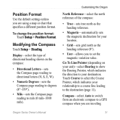
...the magnetic declination for your location. • Grid-sets grid north as the heading reference (0°). • User-allows you to set the magnetic variation value. Go To Line/Pointer (depending on the compass: • Directional ... Pointer, which indicates your destination. Touch Course to select the Course Pointer, which indicates the direction to a GPS compass when you are using a map or chart that specifies a different position format. Modifying the Compass Touch ...mils). Position Format Use the default settings unless you are traveling Oregon Series Owner's Manual 31
...the magnetic declination for your location. • Grid-sets grid north as the heading reference (0°). • User-allows you to set the magnetic variation value. Go To Line/Pointer (depending on the compass: • Directional ... Pointer, which indicates your destination. Touch Course to select the Course Pointer, which indicates the direction to a GPS compass when you are using a map or chart that specifies a different position format. Modifying the Compass Touch ...mils). Position Format Use the default settings unless you are traveling Oregon Series Owner's Manual 31

Owner's Manual
Page 42
...Interfaces: Garmin Proprietary serial, USB mass storage device, NMEA 0183 Data Storage Life: Indefinite; Using Demo Mode Demo mode turns the GPS receiver off for use indoors or for practice. no memory battery required Map Storage: Internal or microSD Card Performance Receiver: more...36 Oregon Series Owner's Manual to 30,000 ft. (from -2,000 ft. The unit does not track satellites in extreme Northern and Southern latitudes)* Resolution: 1 degree Altimeter: Accuracy: ± 10 ft. (± 3 m)* Resolution: 1 ft. (.3 m) Range: from -610 to 9144 m) *Subject to proper user calibration....
...Interfaces: Garmin Proprietary serial, USB mass storage device, NMEA 0183 Data Storage Life: Indefinite; Using Demo Mode Demo mode turns the GPS receiver off for use indoors or for practice. no memory battery required Map Storage: Internal or microSD Card Performance Receiver: more...36 Oregon Series Owner's Manual to 30,000 ft. (from -2,000 ft. The unit does not track satellites in extreme Northern and Southern latitudes)* Resolution: 1 degree Altimeter: Accuracy: ± 10 ft. (± 3 m)* Resolution: 1 ft. (.3 m) Range: from -610 to 9144 m) *Subject to proper user calibration....

