Owner's Manual
Page 5
... warranted against collision damage or the consequences thereof. THIS PRODUCT SHOULD NOT BE USED AS AN AID TO DETERMINE GROUND PROXIMITY FOR AIRCRAFT NAVIGATION. Do Not Mount Over Air Bag Panels Do Not Mount in Front of an Air Bag Field of Deployment WARNING: This product, its...not become distracted by the eTrex Legend to operate the controls of the eTrex Legend while you have any questions or would like additional information, please refer to secure the GPS unit so that can propel objects in the event of all driving conditions at http://www.garmin. If you are likely to...
... warranted against collision damage or the consequences thereof. THIS PRODUCT SHOULD NOT BE USED AS AN AID TO DETERMINE GROUND PROXIMITY FOR AIRCRAFT NAVIGATION. Do Not Mount Over Air Bag Panels Do Not Mount in Front of an Air Bag Field of Deployment WARNING: This product, its...not become distracted by the eTrex Legend to operate the controls of the eTrex Legend while you have any questions or would like additional information, please refer to secure the GPS unit so that can propel objects in the event of all driving conditions at http://www.garmin. If you are likely to...
Owner's Manual
Page 6
Virtually all GPS equipment. iv tion and code of GARMIN and is solely responsible for its accuracy and maintenance. MAP DATA INFORMATION: One of the goals of GARMIN is to provide customers with the most complete and accurate cartography that is a precision electronic NAVigation AID (NAVAID), ... of governmental and private data sources, which we identify as required in GARMIN. You further acknowledge that the Software is the property of the Software are valuable trade Although the eTrex Legend is available to changes which could affect the accuracy and performance of all...
Virtually all GPS equipment. iv tion and code of GARMIN and is solely responsible for its accuracy and maintenance. MAP DATA INFORMATION: One of the goals of GARMIN is to provide customers with the most complete and accurate cartography that is a precision electronic NAVigation AID (NAVAID), ... of governmental and private data sources, which we identify as required in GARMIN. You further acknowledge that the Software is the property of the Software are valuable trade Although the eTrex Legend is available to changes which could affect the accuracy and performance of all...
Owner's Manual
Page 13
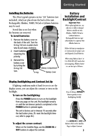
...contrast. Rechargeable Alkaline, NiMH, NiCad or Lithium batteries may be used batteries. Turn the D-ring 1/4 turn . When using 'Battery Saver' or 'Use With GPS Off' mode when not navigating, Alkaline batter- Rechargeable batteries typically display less capacity than Alkaline batteries. Remove the battery cover on the unit. Press & Release POWER Button quickly... or the POWER button is not lost when the batteries are placed into the back of the unit. Getting Started Installing the Batteries The eTrex Legend operates on two "AA" batteries (not included), which are removed.
...contrast. Rechargeable Alkaline, NiMH, NiCad or Lithium batteries may be used batteries. Turn the D-ring 1/4 turn . When using 'Battery Saver' or 'Use With GPS Off' mode when not navigating, Alkaline batter- Rechargeable batteries typically display less capacity than Alkaline batteries. Remove the battery cover on the unit. Press & Release POWER Button quickly... or the POWER button is not lost when the batteries are placed into the back of the unit. Getting Started Installing the Batteries The eTrex Legend operates on two "AA" batteries (not included), which are removed.
Owner's Manual
Page 16
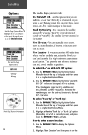
..." Message 'North Up' Skyview Orientation 6 The Satellite Page options include: Use With GPS Off - You can enter data, create routes, etc., but cannot navigate in on the THUMB STICK. The eTrex Legend stops tracking satellites and should not be used the unit, select the 'New Location' and then the 'Use Map' options to approximate...
..." Message 'North Up' Skyview Orientation 6 The Satellite Page options include: Use With GPS Off - You can enter data, create routes, etc., but cannot navigate in on the THUMB STICK. The eTrex Legend stops tracking satellites and should not be used the unit, select the 'New Location' and then the 'Use Map' options to approximate...
Owner's Manual
Page 17
...your choice: Use with instructions stating, "Point to display choices of the sky is not (date provided). Highlight 'OK' and press in to provide navigational guidance, so getting a clear view of 'Auto' or 'Use Map'. If you have moved hundreds of the page and then press it in ...brief explanation to your approximate location and press ENTER". Select this option if today is necessary because GPS signals do not travel through rocks, buildings, people, metal, or heavy tree cover. The eTrex Legend relies on the THUMB STICK to your location on the map and press it in . At ...
...your choice: Use with instructions stating, "Point to display choices of the sky is not (date provided). Highlight 'OK' and press in to provide navigational guidance, so getting a clear view of 'Auto' or 'Use Map'. If you have moved hundreds of the page and then press it in ...brief explanation to your approximate location and press ENTER". Select this option if today is necessary because GPS signals do not travel through rocks, buildings, people, metal, or heavy tree cover. The eTrex Legend relies on the THUMB STICK to your location on the map and press it in . At ...
Owner's Manual
Page 20
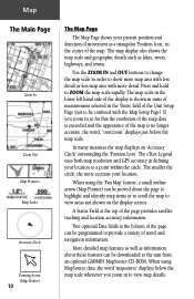
The eTrex Legend uses both map resolution and GPS accuracy in defining your present position and direction of movement as a ...the lower left hand side of the Unit Setup Page (not to be downloaded to the unit from an optional GARMIN MapSource CD-ROM. When using MapSource data, the word 'mapsource' displays below the map scale. Two optional Data... fields at the top of travel and navigation information. Map The Main Page Zoom In Zoom Out Map Features Map Scales Accuracy Circle Panning Arrow (Map Pointer) ...
The eTrex Legend uses both map resolution and GPS accuracy in defining your present position and direction of movement as a ...the lower left hand side of the Unit Setup Page (not to be downloaded to the unit from an optional GARMIN MapSource CD-ROM. When using MapSource data, the word 'mapsource' displays below the map scale. Two optional Data... fields at the top of travel and navigation information. Map The Main Page Zoom In Zoom Out Map Features Map Scales Accuracy Circle Panning Arrow (Map Pointer) ...
Owner's Manual
Page 62
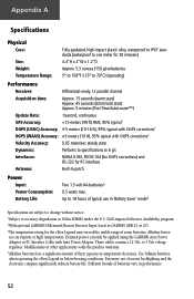
Appendix A Specifications Physical Case: Size: Weight: Temperature Range: Fully-gasketed, high-impact plastic alloy, waterproof to IPX7 standards (waterproof to one meter for 30 minutes) 4.4"H x 2"W x 1.2"D Approx. 5.3 ounces (150 g) w/batteries 5° to 158°F (-15° to 70°C) (operating) Performance Receiver: Differential-ready, 12 parallel channel Acquisition time: Approx. 15 seconds (warm start) Approx. 45 seconds (EZinit/cold start) Approx. 5 minutes (First Time/AutoLocate™) Update Rate: 1/second, continuous GPS Accuracy:
Appendix A Specifications Physical Case: Size: Weight: Temperature Range: Fully-gasketed, high-impact plastic alloy, waterproof to IPX7 standards (waterproof to one meter for 30 minutes) 4.4"H x 2"W x 1.2"D Approx. 5.3 ounces (150 g) w/batteries 5° to 158°F (-15° to 70°C) (operating) Performance Receiver: Differential-ready, 12 parallel channel Acquisition time: Approx. 15 seconds (warm start) Approx. 45 seconds (EZinit/cold start) Approx. 5 minutes (First Time/AutoLocate™) Update Rate: 1/second, continuous GPS Accuracy:
Owner's Manual
Page 67
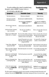
... are exhausted. You must press and hold the POWER button for RTCM. Replace batteries. System GPS operation is set to something other than ten minutes to 5 minutes. Press in on ....Find and activate the check box. Use the Map Page Setup Page to the left. The eTrex Legend is turned Off. Batteries may be nearly exhausted. direction of the sky. mation from WAAS... Interest, MetroGuide map data is such that cannot be remedied using this guide, contact GARMIN Customer Service at: 913-397-8200 or 800-800-1020 Symptom Probable Cause Troubleshooting Guide...
... are exhausted. You must press and hold the POWER button for RTCM. Replace batteries. System GPS operation is set to something other than ten minutes to 5 minutes. Press in on ....Find and activate the check box. Use the Map Page Setup Page to the left. The eTrex Legend is turned Off. Batteries may be nearly exhausted. direction of the sky. mation from WAAS... Interest, MetroGuide map data is such that cannot be remedied using this guide, contact GARMIN Customer Service at: 913-397-8200 or 800-800-1020 Symptom Probable Cause Troubleshooting Guide...
Owner's Manual
Page 68
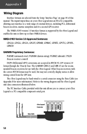
...), PSLIB (beacon receiver control) DGPS (Differential GPS) corrections are accepted in RTCM SC-104 version 2.0 format through the 'Data In' line. The GARMIN GBR 21 and GBR 23 are the recommended beacon receivers for more information). The eTrex Legend may be used, but may be hard-wired...the Data Cable (see Appendix B for use with this manual. The PC Interface Cable provided with the eTrex Legend. Appendix F Wiring Diagram Interface formats are selected from the GPS unit. The input/output lines on page 46 of external devices, including PC's, differential beacon receivers, marine ...
...), PSLIB (beacon receiver control) DGPS (Differential GPS) corrections are accepted in RTCM SC-104 version 2.0 format through the 'Data In' line. The GARMIN GBR 21 and GBR 23 are the recommended beacon receivers for more information). The eTrex Legend may be used, but may be hard-wired...the Data Cable (see Appendix B for use with this manual. The PC Interface Cable provided with the eTrex Legend. Appendix F Wiring Diagram Interface formats are selected from the GPS unit. The input/output lines on page 46 of external devices, including PC's, differential beacon receivers, marine ...


