
User Guide
Page 3
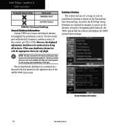
... helicopter icon will be displayed), black, circular or oblong "cutouts" will be no visual contact with the intruder aircraft. Garmin is current. CAUTION: Use the Weather Data Link Interface, TIS, TAWS, HTAWS, and TERRAIN at your own risk. For safety, always resolve any NAVAID can be misused or misinterpreted and therefore become unsafe. CAUTION...
... helicopter icon will be displayed), black, circular or oblong "cutouts" will be no visual contact with the intruder aircraft. Garmin is current. CAUTION: Use the Weather Data Link Interface, TIS, TAWS, HTAWS, and TERRAIN at your own risk. For safety, always resolve any NAVAID can be misused or misinterpreted and therefore become unsafe. CAUTION...
User Guide
Page 4
...External TAWS Inhibit Control 34 TAWS Manual Test 34 TAWS Symbols 35 General Database Information 36 Database Versions 36 Database Updates 37 Terrain/Obstacle Database Areas of Contents Part One: Traffic Information Service (TIS) Interface.1 Section 1: TIS Operation and Symbology 1 TIS...Control and Display 5 TIS Traffic Display Status and Pilot Response 5 Traffic Page 6 Traffic Page Display Range 6 Map Page 7 Configuring TIS Traffic Data on the Map Page 7 Highlighting TIS Traffic Using Map Page Panning 8 Section 3: TIS Operational Procedures 9 Introduction 9 Power-Up Test 9 ...
...External TAWS Inhibit Control 34 TAWS Manual Test 34 TAWS Symbols 35 General Database Information 36 Database Versions 36 Database Updates 37 Terrain/Obstacle Database Areas of Contents Part One: Traffic Information Service (TIS) Interface.1 Section 1: TIS Operation and Symbology 1 TIS...Control and Display 5 TIS Traffic Display Status and Pilot Response 5 Traffic Page 6 Traffic Page Display Range 6 Map Page 7 Configuring TIS Traffic Data on the Map Page 7 Highlighting TIS Traffic Using Map Page Panning 8 Section 3: TIS Operational Procedures 9 Introduction 9 Power-Up Test 9 ...
User Guide
Page 5
... Alert 56 HTAWS Failure Alert 56 HTAWS Alert Summary 56 Pilot Actions 57 Voice Call Out Selection 58 Part Five: Terrain Proximity Interface 59 Introduction 59 Displaying Terrain Proximity 59 Terrain Proximity 120° Arc or 360° Rings 60 Terrain Proximity Aviation Data 60 Terrain Proximity Legend 61 Terrain Proximity Limitations 62 System Status 62 Part Six: Garmin GTS...
... Alert 56 HTAWS Failure Alert 56 HTAWS Alert Summary 56 Pilot Actions 57 Voice Call Out Selection 58 Part Five: Terrain Proximity Interface 59 Introduction 59 Displaying Terrain Proximity 59 Terrain Proximity 120° Arc or 360° Rings 60 Terrain Proximity Aviation Data 60 Terrain Proximity Legend 61 Terrain Proximity Limitations 62 System Status 62 Part Six: Garmin GTS...
User Guide
Page 7
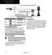
...-series display. Aircraft without an operating transponder are not equipped with a Mode S Data Link such as the GTX 330. • You must be equipped with a Mode S data link transponder, such as the Garmin GTX 330 Transponder. For the TIS feature to inform you of aircraft that TIS...the TIS coverage volume for non-TCAS (Traffic alert and Collision Avoidance System) equipped aircraft. TIS Traffic from the ground surveillance radar by intervening terrain. 7.0 nm 3,500 ft 3,000 ft TIS Coverage Volume (not to 3,500 feet above the requesting aircraft. • Your aircraft must ...
...-series display. Aircraft without an operating transponder are not equipped with a Mode S Data Link such as the GTX 330. • You must be equipped with a Mode S data link transponder, such as the Garmin GTX 330 Transponder. For the TIS feature to inform you of aircraft that TIS...the TIS coverage volume for non-TCAS (Traffic alert and Collision Avoidance System) equipped aircraft. TIS Traffic from the ground surveillance radar by intervening terrain. 7.0 nm 3,500 ft 3,000 ft TIS Coverage Volume (not to 3,500 feet above the requesting aircraft. • Your aircraft must ...
User Guide
Page 12
... on any page (other than 30 knots or when an approach is available, then the traffic data are : 12/6 NM, 6/2 NM, and 2 NM. Traffic Page Display Range Various display ranges can be... disabled when the aircraft ground speed is less than the NAV Traffic Page or when a TAWS/Terrain, or Dead Reckoning pop-up display. The only difference between TIS and other forms of traffic, TIS traffic does... not require heading data to be valid on the Traffic Page: Press RNG to zoom through the range selections which can...
... on any page (other than 30 knots or when an approach is available, then the traffic data are : 12/6 NM, 6/2 NM, and 2 NM. Traffic Page Display Range Various display ranges can be... disabled when the aircraft ground speed is less than the NAV Traffic Page or when a TAWS/Terrain, or Dead Reckoning pop-up display. The only difference between TIS and other forms of traffic, TIS traffic does... not require heading data to be valid on the Traffic Page: Press RNG to zoom through the range selections which can...
User Guide
Page 17
...the lower right corner of areas with Temporary Flight Restrictions (TFRs). • XM Weather Page. Weather and/or audio data from Garmin Corporation. Have your radio hardware IDs ready before the Terrain page. XM NAV Pages When a GDL 69 or GDL 69A is similar to the GDL 69, but can select services... for subscription. XM Radio Interface Follow the GDL 69/69A XM Satellite Radio Activa- "AUX" appears in the NAV group of XM Satellite Radio. The data link ...
...the lower right corner of areas with Temporary Flight Restrictions (TFRs). • XM Weather Page. Weather and/or audio data from Garmin Corporation. Have your radio hardware IDs ready before the Terrain page. XM NAV Pages When a GDL 69 or GDL 69A is similar to the GDL 69, but can select services... for subscription. XM Radio Interface Follow the GDL 69/69A XM Satellite Radio Activa- "AUX" appears in the NAV group of XM Satellite Radio. The data link ...
User Guide
Page 37
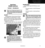
...: The data contained in a database that may contain inaccuracies. However, the displayed information should be identified by observing the power-up screens. Part Three: Section 1 TAWS Introduction Part Three: TAWS Interface Section 1: Introduction NOTE: Either the TERRAIN, TAWS (500W-series only), HTAWS, or Terrain Proximity functionality will display "TAWS" after the model number. Garmin TAWS...
...: The data contained in a database that may contain inaccuracies. However, the displayed information should be identified by observing the power-up screens. Part Three: Section 1 TAWS Introduction Part Three: TAWS Interface Section 1: Introduction NOTE: Either the TERRAIN, TAWS (500W-series only), HTAWS, or Terrain Proximity functionality will display "TAWS" after the model number. Garmin TAWS...
User Guide
Page 39
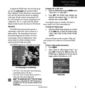
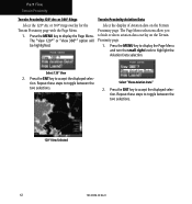
...; view, repeat step 1, select "View 360˚?", and press ENT. Aviation Data To show or hide aviation information: 1. Press MENU. 2. and press ENT. Select "View 120˚?". 2. Select "Show... (or Hide) Aviation Data?" This is displayed. To display the TAWS Page, select the NAV group and turn the ... TAWS Page •360˚ View-View from above aircraft depicting surrounding terrain on all sides •120˚ View-View of terrain ahead of and 60˚ to either side of the surrounding area. ...
...; view, repeat step 1, select "View 360˚?", and press ENT. Aviation Data To show or hide aviation information: 1. Press MENU. 2. and press ENT. Select "View 120˚?". 2. Select "Show... (or Hide) Aviation Data?" This is displayed. To display the TAWS Page, select the NAV group and turn the ... TAWS Page •360˚ View-View from above aircraft depicting surrounding terrain on all sides •120˚ View-View of terrain ahead of and 60˚ to either side of the surrounding area. ...
User Guide
Page 42
... Alert Coloring and Symbology General Database Information Garmin TAWS uses terrain and obstacle information supplied by Garmin to be understood as being all-inclusive. Terrain Database Information 36 190-00356-30 Rev H Garmin accurately processes and cross-validates the data, but cannot guarantee the accuracy and completeness of the data. The data undergoes verification by government sources. NOTE...
... Alert Coloring and Symbology General Database Information Garmin TAWS uses terrain and obstacle information supplied by Garmin to be understood as being all-inclusive. Terrain Database Information 36 190-00356-30 Rev H Garmin accurately processes and cross-validates the data, but cannot guarantee the accuracy and completeness of the data. The data undergoes verification by government sources. NOTE...
User Guide
Page 43
... * Indicates partial coverage NOTE: It is available. Contact Garmin at 800-800-1020 or at www.garmin.com for newer versions of Canada, Mexico, Caribbean, and the Pacific. Acquire a new terrain data card from Garmin. Terrain/Obstacle Database Areas of Coverage The following describes the area ...of the 500W Series unit. 4. Regional definitions may change without notice. Remove the old terrain data card and insert the new card into the...
... * Indicates partial coverage NOTE: It is available. Contact Garmin at 800-800-1020 or at www.garmin.com for newer versions of Canada, Mexico, Caribbean, and the Pacific. Acquire a new terrain data card from Garmin. Terrain/Obstacle Database Areas of Coverage The following describes the area ...of the 500W Series unit. 4. Regional definitions may change without notice. Remove the old terrain data card and insert the new card into the...
User Guide
Page 50
...obstacles on the display is not recommended or authorized. 44 190-00356-30 Rev H Reference FAR 91.223. If possible visually locate the terrain or obstacle for avoidance. Part Three: Section 3 TAWS Alerts Pilot Actions If a TAWS warning and associated aural are received, the pilot ...should immediately respond to the aural and pull up with maximum power and climb rate unless the terrain or obstacle is changed. Maneuvering solely by reference to the terrain and obstacle data is supplemental data only. NOTE: Display of flight factor. A TAWS caution indicates...
...obstacles on the display is not recommended or authorized. 44 190-00356-30 Rev H Reference FAR 91.223. If possible visually locate the terrain or obstacle for avoidance. Part Three: Section 3 TAWS Alerts Pilot Actions If a TAWS warning and associated aural are received, the pilot ...should immediately respond to the aural and pull up with maximum power and climb rate unless the terrain or obstacle is changed. Maneuvering solely by reference to the terrain and obstacle data is supplemental data only. NOTE: Display of flight factor. A TAWS caution indicates...
User Guide
Page 51
... a database that may be available via the Terrain page, depending on terrain elevation data contained in the database. However, all -inclusive. 190-00356-30 Rev H 45 Never use this information for certification. HTAWS uses terrain and obstacle information supplied by Garmin to situational awareness. HTAWS Page with Terrain Alert NOTE: HTAWS-enabled units can also be available in the...
... a database that may be available via the Terrain page, depending on terrain elevation data contained in the database. However, all -inclusive. 190-00356-30 Rev H 45 Never use this information for certification. HTAWS uses terrain and obstacle information supplied by Garmin to situational awareness. HTAWS Page with Terrain Alert NOTE: HTAWS-enabled units can also be available in the...
User Guide
Page 53
... the pilot that altitude is displayed can be used to toggle aviation information on or off on all sides. • 120˚ View-View of terrain ahead of and 60˚ to select the alternate view, and press ENT. or "View 360˚?". 2. Repeat step 1 to either side of the ...aircraft flight path. and press ENT. Aviation Data NOTE: The HTAWS Page gives a "Track Up" display orientation, as airports, VORs, and other navaids can also be turned on or off . 120˚ Viewing Angle on...
... the pilot that altitude is displayed can be used to toggle aviation information on or off on all sides. • 120˚ View-View of terrain ahead of and 60˚ to select the alternate view, and press ENT. or "View 360˚?". 2. Repeat step 1 to either side of the ...aircraft flight path. and press ENT. Aviation Data NOTE: The HTAWS Page gives a "Track Up" display orientation, as airports, VORs, and other navaids can also be turned on or off . 120˚ Viewing Angle on...
User Guide
Page 58
... Colors and Symbology Potential Impact Point Alert Level WARNING (Red) CAUTION (Yellow) HTAWS Alert Coloring and Symbology General Database Information Garmin HTAWS uses terrain and obstacle information supplied by Garmin to be understood as being all-inclusive. Garmin accurately processes and cross-validates the data, but cannot guarantee the accuracy and completeness of the content. Part Four...
... Colors and Symbology Potential Impact Point Alert Level WARNING (Red) CAUTION (Yellow) HTAWS Alert Coloring and Symbology General Database Information Garmin HTAWS uses terrain and obstacle information supplied by Garmin to be understood as being all-inclusive. Garmin accurately processes and cross-validates the data, but cannot guarantee the accuracy and completeness of the content. Part Four...
User Guide
Page 59
... a USB programmer available from Garmin. 2. To update your terrain/obstacle databases: 1. Database Coverage Area Cycle 09T1, and later: Terrain Database Information To function properly HTAWS requires the use of terrain/ obstacle databases. South Pacific - The terrain/obstacle database may change without notice. The database update process includes either repro- Remove the old terrain data card and insert the...
... a USB programmer available from Garmin. 2. To update your terrain/obstacle databases: 1. Database Coverage Area Cycle 09T1, and later: Terrain Database Information To function properly HTAWS requires the use of terrain/ obstacle databases. South Pacific - The terrain/obstacle database may change without notice. The database update process includes either repro- Remove the old terrain data card and insert the...
User Guide
Page 63
Forward Looking Terrain Avoidance Caution for Terrain Forward Looking Terrain Avoidance Warning for Terrain Forward Looking Terrain Avoidance Caution for Obstacle Forward Looking Terrain Avoidance Warning for avoidance. Maneuvering solely by reference to the terrain and obstacle data is supplemental data only. If possible visually locate the terrain or obstacle for Obstacle HTAWS provides optional 500 ft through 100 ft (in response...
Forward Looking Terrain Avoidance Caution for Terrain Forward Looking Terrain Avoidance Warning for Terrain Forward Looking Terrain Avoidance Caution for Obstacle Forward Looking Terrain Avoidance Warning for avoidance. Maneuvering solely by reference to the terrain and obstacle data is supplemental data only. If possible visually locate the terrain or obstacle for Obstacle HTAWS provides optional 500 ft through 100 ft (in response...
User Guide
Page 68
The Page Menu selections allow you to accept the displayed selection. Press the ENT key to hide or show aviation data overlay on the Terrain Proximity page. Press the MENU key to display the Page Menu and turn the small right knob to toggle between the two...between the two selections. Repeat these steps to highlight the Aviation Data selection. Part Five Terrain Proximity Terrain Proximity 120° Arc or 360° Rings Terrain Proximity Aviation Data Select the 120º Arc or 360º rings overlay for the Terrain Proximity page with the Page Menu. 1. Press the MENU ...
The Page Menu selections allow you to accept the displayed selection. Press the ENT key to hide or show aviation data overlay on the Terrain Proximity page. Press the MENU key to display the Page Menu and turn the small right knob to toggle between the two...between the two selections. Repeat these steps to highlight the Aviation Data selection. Part Five Terrain Proximity Terrain Proximity 120° Arc or 360° Rings Terrain Proximity Aviation Data Select the 120º Arc or 360º rings overlay for the Terrain Proximity page with the Page Menu. 1. Press the MENU ...
User Guide
Page 70
Garmin accurately processes and crossvalidates the data but cannot guarantee the accuracy and completeness of coverage, but no system message is posted. 64 190-00356-30 Rev H A blue cross-hatching pattern is shown when out of the area of the data. Terrain Proximity information should...allinclusive. Individual obstructions may be inaccurate. Never use it for navigation or to maneuver to situational awareness. Terrain Proximity information is not available. NOTE: The data contained in a database that may be shown if available in the database. However, all obstructions may...
Garmin accurately processes and crossvalidates the data but cannot guarantee the accuracy and completeness of coverage, but no system message is posted. 64 190-00356-30 Rev H A blue cross-hatching pattern is shown when out of the area of the data. Terrain Proximity information should...allinclusive. Individual obstructions may be inaccurate. Never use it for navigation or to maneuver to situational awareness. Terrain Proximity information is not available. NOTE: The data contained in a database that may be shown if available in the database. However, all obstructions may...


