User Guide
Page 2
... in operation may be used without the express permission of Garmin Ltd. TIS Traffic Display and Weather Data Link are available only when the 400W/500W units are trademarks of Garmin Ltd. Garmin® is a registered trademark, and GTX™ and GDL™ are configured with the GTX 330 Mode S Transponder and GDL 69/69A Data Link Transceiver, respectively. 190-00356-30 Rev H Foreward This Pilot's Guide Addendum is subject to change...
... in operation may be used without the express permission of Garmin Ltd. TIS Traffic Display and Weather Data Link are available only when the 400W/500W units are trademarks of Garmin Ltd. Garmin® is a registered trademark, and GTX™ and GDL™ are configured with the GTX 330 Mode S Transponder and GDL 69/69A Data Link Transceiver, respectively. 190-00356-30 Rev H Foreward This Pilot's Guide Addendum is subject to change...

User Guide
Page 3
... other aircraft. CAUTION: Use the Weather Data Link Interface, TIS, TAWS, HTAWS, and TERRAIN at your Flight Service Station for those locations. When in aircraft. The GPS altitude format calculated by pressure altimeters in actual use . Updates are not a replacement for navigation. Always confirm TFR data through official sources and contact your own risk. TIS should be fully understood to ensure proper use , carefully compare indications from altitude displayed by the Garmin 400W/500W Series units is...
... other aircraft. CAUTION: Use the Weather Data Link Interface, TIS, TAWS, HTAWS, and TERRAIN at your Flight Service Station for those locations. When in aircraft. The GPS altitude format calculated by pressure altimeters in actual use . Updates are not a replacement for navigation. Always confirm TFR data through official sources and contact your own risk. TIS should be fully understood to ensure proper use , carefully compare indications from altitude displayed by the Garmin 400W/500W Series units is...
User Guide
Page 4
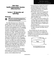
... Updates 37 Terrain/Obstacle Database Areas of Contents Part One: Traffic Information Service (TIS) Interface.1 Section 1: TIS Operation and Symbology 1 TIS Operation 1 How TIS differs from TCAS 2 TIS Limitations 2 Improving TIS 3 TIS Symbology 3 Section 2: Control and Display 5 TIS Traffic Display Status and Pilot Response 5 Traffic Page 6 Traffic Page Display Range 6 Map Page 7 Configuring TIS Traffic Data on the Map Page 7 Highlighting TIS Traffic Using Map Page Panning 8 Section 3: TIS Operational Procedures 9 Introduction 9 Power-Up Test 9 Manual Override 10 Flight...
... Updates 37 Terrain/Obstacle Database Areas of Contents Part One: Traffic Information Service (TIS) Interface.1 Section 1: TIS Operation and Symbology 1 TIS Operation 1 How TIS differs from TCAS 2 TIS Limitations 2 Improving TIS 3 TIS Symbology 3 Section 2: Control and Display 5 TIS Traffic Display Status and Pilot Response 5 Traffic Page 6 Traffic Page Display Range 6 Map Page 7 Configuring TIS Traffic Data on the Map Page 7 Highlighting TIS Traffic Using Map Page Panning 8 Section 3: TIS Operational Procedures 9 Introduction 9 Power-Up Test 9 Manual Override 10 Flight...
User Guide
Page 5
... 2: HTAWS Operation 46 HTAWS Alerting 46 Baro-Corrected Altitude 46 Power Up 46 HTAWS Page 46 Page Menu 47 Inhibit Mode 48 External HTAWS Inhibit Control 48 Reduced Protection Mode 48 Mute Active Caution 49 HTAWS Manual Test 50 HTAWS Legend 50 HTAWS Symbols 51 General Database Information 52 Database Versions 52 Database Updates 53 Terrain Database Areas of Coverage 53 Obstacle Database Areas of Coverage 54 Section 3: HTAWS Alerts 54 Forward Looking Terrain Avoidance 55 Voice Call Out Aural Alert 55 HTAWS...
... 2: HTAWS Operation 46 HTAWS Alerting 46 Baro-Corrected Altitude 46 Power Up 46 HTAWS Page 46 Page Menu 47 Inhibit Mode 48 External HTAWS Inhibit Control 48 Reduced Protection Mode 48 Mute Active Caution 49 HTAWS Manual Test 50 HTAWS Legend 50 HTAWS Symbols 51 General Database Information 52 Database Versions 52 Database Updates 53 Terrain Database Areas of Coverage 53 Obstacle Database Areas of Coverage 54 Section 3: HTAWS Alerts 54 Forward Looking Terrain Avoidance 55 Voice Call Out Aural Alert 55 HTAWS...
User Guide
Page 7
... service. Surveillance data includes all transponderequipped aircraft within the coverage volume. TIS is a groundbased service providing relative location of this Addendum assumes the user has experience operating the 400W/500W Series units and the Garmin GTX 330 Transponder. The TIS ground sensor uses real-time track reports to TIS. Part One: Section 1 TIS Operation and Symbology Part One: Traffic Information Service (TIS) Interface Section 1: TIS Operation and Symbology TIS Operation NOTE: Part One of all ATCRBS (Air Traffic Control Radar Beacon System) Mode A and Mode C transponder...
... service. Surveillance data includes all transponderequipped aircraft within the coverage volume. TIS is a groundbased service providing relative location of this Addendum assumes the user has experience operating the 400W/500W Series units and the Garmin GTX 330 Transponder. The TIS ground sensor uses real-time track reports to TIS. Part One: Section 1 TIS Operation and Symbology Part One: Traffic Information Service (TIS) Interface Section 1: TIS Operation and Symbology TIS Operation NOTE: Part One of all ATCRBS (Air Traffic Control Radar Beacon System) Mode A and Mode C transponder...
User Guide
Page 8
... data to extrapolate intruders to "see 2 190-00356-30 Rev H These errors primarily affect relative bearing information and traffic target track vector (it has some system limitations that provided to present the intruders in a "real time" position, the TIS ground station uses a "predictive algorithm" in the cockpit. While TIS is collected one -second update rate, while TIS uses the terminal Mode S ground interrogator and its tracking software. TIS information...
... data to extrapolate intruders to "see 2 190-00356-30 Rev H These errors primarily affect relative bearing information and traffic target track vector (it has some system limitations that provided to present the intruders in a "real time" position, the TIS ground station uses a "predictive algorithm" in the cockpit. While TIS is collected one -second update rate, while TIS uses the terminal Mode S ground interrogator and its tracking software. TIS information...
User Guide
Page 9
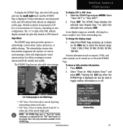
... configured for display in either aircraft abruptly changes course within ¼ NM, TIS may be useful information. A Traffic Advisory (TA) symbol appears as an open diamond. Part One: Section 1 TIS Operation and Symbology and avoid." These are displayed as a solid diamond, and other traffic is suggested that crosses the client aircraft course at FAA FSSs, General Aviation District Offices, Flight Standards District Offices, and General Aviation Fixed Based Operations...
... configured for display in either aircraft abruptly changes course within ¼ NM, TIS may be useful information. A Traffic Advisory (TA) symbol appears as an open diamond. Part One: Section 1 TIS Operation and Symbology and avoid." These are displayed as a solid diamond, and other traffic is suggested that crosses the client aircraft course at FAA FSSs, General Aviation District Offices, Flight Standards District Offices, and General Aviation Fixed Based Operations...
User Guide
Page 15
... visual data are being received from the 400W/500W display or on a course that will intercept (defined by system configuration at the time of installation, see illustration). The flight crew should not start evasive maneuvers using information from the GTX 330. If the flight crew cannot visually acquire the aircraft, they should be a threat (see your aircraft on a traffic advisory only. Part One: Section 3 TIS Operational Procedures Section 3: TIS Operational...
... visual data are being received from the 400W/500W display or on a course that will intercept (defined by system configuration at the time of installation, see illustration). The flight crew should not start evasive maneuvers using information from the GTX 330. If the flight crew cannot visually acquire the aircraft, they should be a threat (see your aircraft on a traffic advisory only. Part One: Section 3 TIS Operational Procedures Section 3: TIS Operational...
User Guide
Page 16
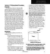
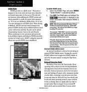
... hand corner of operation to manually override automatic operation. Flight Procedures Once the aircraft is announced, conduct a visual search for a description of installation) the system switches from operating mode to standby mode. Press ENT to confirm. NOTE: This may be manually overridden by system configuration at the time of pilot responses to TIS display messages. The 400W/500W Series unit displays OPER in a dual transponder installation where the GTX 330 with TIS is not the...
... hand corner of operation to manually override automatic operation. Flight Procedures Once the aircraft is announced, conduct a visual search for a description of installation) the system switches from operating mode to standby mode. Press ENT to confirm. NOTE: This may be manually overridden by system configuration at the time of pilot responses to TIS display messages. The 400W/500W Series unit displays OPER in a dual transponder installation where the GTX 330 with TIS is not the...
User Guide
Page 17
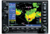
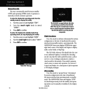
... the Terrain page. The IDs can be used, the unit tion Instructions (190-00355-04) enclosed with Temporary Flight Restrictions (TFRs). • XM Weather Page. The Map page (the second page in the activation process. This page is similar to locate the radio hardware IDs. The GDL 69A is like the map page, but also receives audio entertainment broadcasts from a data service of the screen. XM Radio Pages...
... the Terrain page. The IDs can be used, the unit tion Instructions (190-00355-04) enclosed with Temporary Flight Restrictions (TFRs). • XM Weather Page. The Map page (the second page in the activation process. This page is similar to locate the radio hardware IDs. The GDL 69A is like the map page, but also receives audio entertainment broadcasts from a data service of the screen. XM Radio Pages...
User Guide
Page 31
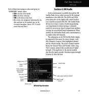
... series units serve as the display and control head for standard time on signal from satellites, coverage far exceeds land-based transmissions. Maximum signal strength is composed of four areas: the Active channel, available Channels, Category of the highlighted channel, and the Volume setting. Based on the Greenwich meridian: that the date and time are for your remotely mounted GDL 69A. When enabled, the XM Satellite Radio audio...
... series units serve as the display and control head for standard time on signal from satellites, coverage far exceeds land-based transmissions. Maximum signal strength is composed of four areas: the Active channel, available Channels, Category of the highlighted channel, and the Volume setting. Based on the Greenwich meridian: that the date and time are for your remotely mounted GDL 69A. When enabled, the XM Satellite Radio audio...
User Guide
Page 37
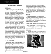
.... Terrain information should never be used as being all-inclusive. 190-00356-30 Rev H 31 Part Three: Section 1 TAWS Introduction Part Three: TAWS Interface Section 1: Introduction NOTE: Either the TERRAIN, TAWS (500W-series only), HTAWS, or Terrain Proximity functionality will display "TAWS" after the model number. Overview Garmin's Terrain Awareness Warning System (TAWS) is based on the installed hardware and configuration. Garmin TAWS satisfies TSO-C151b Class B requirements for Part 135 turbine aircraft operations...
.... Terrain information should never be used as being all-inclusive. 190-00356-30 Rev H 31 Part Three: Section 1 TAWS Introduction Part Three: TAWS Interface Section 1: Introduction NOTE: Either the TERRAIN, TAWS (500W-series only), HTAWS, or Terrain Proximity functionality will display "TAWS" after the model number. Overview Garmin's Terrain Awareness Warning System (TAWS) is based on the installed hardware and configuration. Garmin TAWS satisfies TSO-C151b Class B requirements for Part 135 turbine aircraft operations...
User Guide
Page 38
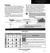
... Operation TAWS Alerting TAWS uses information provided from the GPS receiver to the surrounding terrain and obstacles. GPS-MSL altitude accuracy is affected by the International Standard Atmosphere (ISA) model (where pressure, temperature, and lapse rates have fixed values), it is in relation to provide a horizontal position and altitude. defined by factors such as satellite geometry, but it is used to calculate and "predict" the aircraft's flight...
... Operation TAWS Alerting TAWS uses information provided from the GPS receiver to the surrounding terrain and obstacles. GPS-MSL altitude accuracy is affected by the International Standard Atmosphere (ISA) model (where pressure, temperature, and lapse rates have fixed values), it is in relation to provide a horizontal position and altitude. defined by factors such as satellite geometry, but it is used to calculate and "predict" the aircraft's flight...
User Guide
Page 41
... aircraft intersect, the display automatically zooms in to the maximum zoom range on the TAWS and NAV pages) is associated with an alert severity level. Terrain graphics and visual annunciations also use these color assignments. Gray/White obstacles are used to aircraft altitude. Each color is controlled by the NAV map's "Setup Map" menu option in the "Terrain" group under the "Obstacles" option. Part Three: Section 2 TAWS Operation...
... aircraft intersect, the display automatically zooms in to the maximum zoom range on the TAWS and NAV pages) is associated with an alert severity level. Terrain graphics and visual annunciations also use these color assignments. Gray/White obstacles are used to aircraft altitude. Each color is controlled by the NAV map's "Setup Map" menu option in the "Terrain" group under the "Obstacles" option. Part Three: Section 2 TAWS Operation...
User Guide
Page 51
... terrain/obstacle database. Overview Garmin's Helicopter Terrain Awareness Warning System (HTAWS) is based on the installed hardware and configuration. Never use it for "HTAWS." HTAWS uses terrain and obstacle information supplied by Garmin to the flight path of the aircraft. Garmin TAWS satisfies TSO-C194 requirements for navigation. HTAWS-enabled units can be identified by going to the Terrain page and checking the upper left-corner for navigation or to maneuver to avoid terrain. Operating Criteria Garmin HTAWS requires...
... terrain/obstacle database. Overview Garmin's Helicopter Terrain Awareness Warning System (HTAWS) is based on the installed hardware and configuration. Never use it for "HTAWS." HTAWS uses terrain and obstacle information supplied by Garmin to the flight path of the aircraft. Garmin TAWS satisfies TSO-C194 requirements for navigation. HTAWS-enabled units can be identified by going to the Terrain page and checking the upper left-corner for navigation or to maneuver to avoid terrain. Operating Criteria Garmin HTAWS requires...
User Guide
Page 52
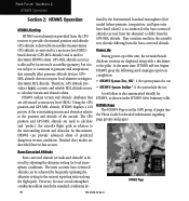
... with a disclaimer to provide a horizontal position and altitude. Using the GPS position and GPS-MSL altitude, HTAWS displays a 2-D picture of pages (see the Pilot's Guide for the baro-corrected altitude (as shown in the HTAWS Alert Summary table. Power Up During power-up of the aircraft. Part Four: Section 2 HTAWS Operation Section 2: HTAWS Operation HTAWS Alerting HTAWS uses information provided from the GPS receiver to the pilot. HTAWS gives the following aural messages upon test completion: • "HTAWS System Test, OK", if the...
... with a disclaimer to provide a horizontal position and altitude. Using the GPS position and GPS-MSL altitude, HTAWS displays a 2-D picture of pages (see the Pilot's Guide for the baro-corrected altitude (as shown in the HTAWS Alert Summary table. Power Up During power-up of the aircraft. Part Four: Section 2 HTAWS Operation Section 2: HTAWS Operation HTAWS Alerting HTAWS uses information provided from the GPS receiver to the pilot. HTAWS gives the following aural messages upon test completion: • "HTAWS System Test, OK", if the...
User Guide
Page 53
... of the MSL altitude display reminds the pilot that altitude is the only orientation available for a more complete view of the surrounding area. To change the display range: 1. Select "Show (or Hide) Aviation Data?" The acknowledge caution alert functionality suppresses the issuance of the aircraft flight path. Pressing the CLR key when the HTAWS Page is displayed can be used to toggle aviation information on or off...
... of the MSL altitude display reminds the pilot that altitude is the only orientation available for a more complete view of the surrounding area. To change the display range: 1. Select "Show (or Hide) Aviation Data?" The acknowledge caution alert functionality suppresses the issuance of the aircraft flight path. Pressing the CLR key when the HTAWS Page is displayed can be used to toggle aviation information on or off...
User Guide
Page 54
HTAWS configured units will always start up with a minimum number of maintaining clearance from terrain and obstacles. tion alerts. tions and landings off in normal mode. See section 3 for more information on the Menu. When conducting en route operations and operations from published airports and heliports HTAWS should use discretion when inhibiting the HTAWS system and always remember to speed. To inhibit HTAWS alerts: 1. This automatic "TAWS INHB" cannot...
HTAWS configured units will always start up with a minimum number of maintaining clearance from terrain and obstacles. tion alerts. tions and landings off in normal mode. See section 3 for more information on the Menu. When conducting en route operations and operations from published airports and heliports HTAWS should use discretion when inhibiting the HTAWS system and always remember to speed. To inhibit HTAWS alerts: 1. This automatic "TAWS INHB" cannot...
User Guide
Page 67
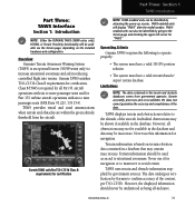
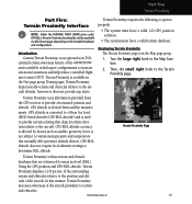
... any alerts. GPS-MSL altitude does not require local altimeter settings to the Terrain Proximity page. In this manner, Terrain Proximity increases awareness of the aircraft. Part Five Terrain Proximity Part Five: Terrain Proximity Interface NOTE: Either the TERRAIN, TAWS (500W-series only), HTAWS, or Terrain Proximity functionality will be available via the Terrain page, depending on the installed hardware and configuration. . Terrain Proximity depicts nearby terrain and obstacles relative to the aircraft altitude...
... any alerts. GPS-MSL altitude does not require local altimeter settings to the Terrain Proximity page. In this manner, Terrain Proximity increases awareness of the aircraft. Part Five Terrain Proximity Part Five: Terrain Proximity Interface NOTE: Either the TERRAIN, TAWS (500W-series only), HTAWS, or Terrain Proximity functionality will be available via the Terrain page, depending on the installed hardware and configuration. . Terrain Proximity depicts nearby terrain and obstacles relative to the aircraft altitude...
User Guide
Page 75
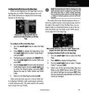
... from the Map Setup Menu on the Map Page if aircraft heading data is available. The GTS 800 shows these PAs as cyan). Turn the small right knob to choose which traffic is displayed (all traffic, traffic and proximity advisories, or traffic advisories only). The flashing cursor highlights the GROUP field. Traffic mode allows the operator to select "Setup Map?" and press ENT. 4. Selections for Traffic Symbol and Traffic Label. 5. NOTE...
... from the Map Setup Menu on the Map Page if aircraft heading data is available. The GTS 800 shows these PAs as cyan). Turn the small right knob to choose which traffic is displayed (all traffic, traffic and proximity advisories, or traffic advisories only). The flashing cursor highlights the GROUP field. Traffic mode allows the operator to select "Setup Map?" and press ENT. 4. Selections for Traffic Symbol and Traffic Label. 5. NOTE...


