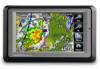
Garmin aera 560 Support Question
Garmin aera 560 Support Question
Find answers below for this question about Garmin aera 560.Need a Garmin aera 560 manual? We have 10 online manuals for this item!
Question posted by bbarnard2012 on November 26th, 2012
Aviation Data Missing How Do I Refind
The person who posted this question about this Garmin product did not include a detailed explanation. Please use the "Request More Information" button to the right if more details would help you to answer this question.
Current Answers
Related Garmin aera 560 Manual Pages
Automotive Quick Start Manual - Page 5
...page or the
Lane Assist page (550 and 560 models).
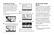
➎ Touch to access the XM ...from the route, your aera recalculates the route and provides...and directions at the top of your aera guides you travel , your GXM 40 ...to zoom in the automotive cradle or the aviation mount.
➐ Touch to view the...service is only available on the aera 510 and 560 models.
Following Your Route
Your ...
Aviation Quick Reference Guide - Page 6
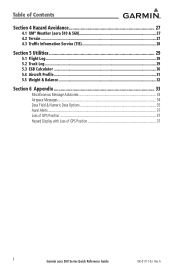
...® Weather (aera 510 & 560 27 4.2 Terrain...27 4.3 Traffic Information Service (TIS 28
Section 5 Utilities 29
5.1 Flight Log...29 5.2 Track Log...29 5.3 E6B Calculator...30 5.4 Aircraft Profile...31 5.5 Weight & Balance...32
Section 6 Appendix 33
Miscellaneous Message Advisories 33 Airspace Messages...34 Data Field & Numeric Data Options 35 Aural Alerts...37 Loss of GPS Position...37...
Aviation Quick Reference Guide - Page 11
...data. Utilities
Appendix
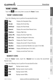
Nearest Icons
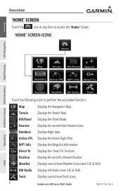
From the 'Home' Screen, touch the Nearest Icon to perform the associated function:
Airport Displays nearest airports.
Displays XM Radio (aera 510 & 560...). Displays the second-level Nearest Icons.
Displays second-level Tools Icons. Displays the Panel Mode. Airport WX Displays nearest airport weather. Overview
GPS ...
Pilot's Guide - Page 8
... polarized eyewear may not be updated outside of normal business hours.
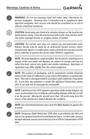
Confirm data currency through alternate sources and contact your local FSS for primary navigation. Warnings, Cautions &...than 100 yards away from GPS repeaters operating inside nearby hangars can cause an intermittent loss of equipment may not reflect the most current aera system and aviation databases. A
Depictions of...
Pilot's Guide - Page 10

... information 52
2.6 Direct-to Navigation 64
Section 3 Flight Planning 67
3.1 Introduction...67 Data Fields...67
3.2 Flight Plan Creation 68 Adding Waypoints to an Existing Flight Plan 70
...Activating Vectors-to-Final 78
Section 4 Hazard Avoidance 79
4.1 XM® Weather (aera 510 & 560 79 Activating Services...79 XM Satellite Weather Products 80 Using XM Satellite Weather Products ...
Pilot's Guide - Page 11

... 107 5.3 XM® Radio (aera 510 & 560 109
Activating XM Satellite Radio Services 110 Using XM Radio...111
Section 6 Appendices 119
Appendix A: Messages, Alerts & Data Field Options 119 Miscellaneous Message Advisories 119 Airspace Messages...121 Data Field & Numeric Data Options 121 Aural Alerts...123
Appendix B: Abnormal Operation 125 Loss of GPS Position...125 Hazard Display with...
Pilot's Guide - Page 16
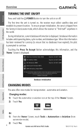
..., which allows the receiver to turn the unit on , the receiver must collect satellite data and establish its present location. Touching the Press To Accept Button acknowledges this information has been reviewed for transportation: automotive and aviation. To ensure proper initialization, the aera is prompted to continue.
Changing modes: 1) Touch the automotive or...
Pilot's Guide - Page 18
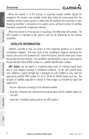
.... Gray bar-Receiver has collected the necessary data and the satellite signal can be helpful in troubleshooting weak (or missing) signal levels due to determine the satellites that should be used for the indicated satellite
- Green bar-Satellite is looking for the GPS solution
Appendices
Index
6
Garmin aera 500 Series Pilot's Guide
190-01117...
Pilot's Guide - Page 20
... Screen Icons
GPS Navigation
Additional ...aera 510 & 560). A
Index
WPT Info Displays the Waypoint Information.
Terrain
Displays the Terrain Map.
Weather Displays second-level Weather Icons (aera 510 & 560...).
Nearest Displays the second-level Nearest Icons. Active FPL Displays the Active Flight Plan. Tools
Displays second-level Tools Icons.
8
Garmin aera...
Pilot's Guide - Page 29
..., land data (highways, cities, lakes, rivers, borders, etc.) with names
• Map Pointer information (distance and bearing to the GPS Navigation section for more information on Map Display Setup. Overview
GPS Navigation
Overview
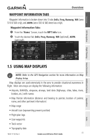
Waypoint Information Tabs
Waypoint information is broken down into 5 tabs (Info, Freq, Runway, WX (aera 510 & 560 only), and AOPA (aera 550 & 560 Americas...
Pilot's Guide - Page 43
... is shown as a magenta line on GPS calculations. A
Garmin aera 500 Series Pilot's Guide
31
The basemap...GPS Navigation
Flight Planning Hazard Avoidance Additional Features
Section 2 GPS Navigation
GPS Navigation
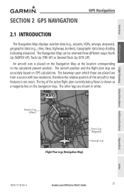
2.1 Introduction
The Navigation Map displays aviation data (e.g., airports, VORs, airways, airspaces), geographic data (e.g., cities, lakes, highways, borders), topographic data...
Pilot's Guide - Page 79

... a time and becomes the active flight plan. Data Fields
The Active and Saved Flight Plan Data Fields can be changed or updated, the aera automatically updates the information if the procedure has not...in the aera.
Changing the information shown in memory. Up to 50 flight plans with an approach, the aera uses the waypoint information from final approach fix to missed approach point...
Pilot's Guide - Page 80

... is shown on the navigation maps. A
Appendices
Index Data Fields
Active Leg Option Menu
Active Flight Plan
68
Garmin aera 500 Series Pilot's Guide
190-01117-02 Rev. Data Field Button
GPS Navigation
Additional Features Hazard Avoidance Flight Planning
Flight Plan Data Fields
3.2 Flight Plan Creation
The active flight plan is the flight plan to...
Pilot's Guide - Page 91
Overview
GPS Navigation
Flight Planning Hazard Avoidance Additional Features
Hazard Avoidance
Section 4 Hazard Avoidance
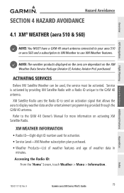
4.1 XM® Weather (aera 510 & 560)
NOTE: You MUST have a GXM 40 smart antenna connected to your aera 510 or aera 560 and a subscription to XM Weather to display weather data and/or entertainment programming provided through the GXM 40 antenna. XM Satellite Radio...
Pilot's Guide - Page 97
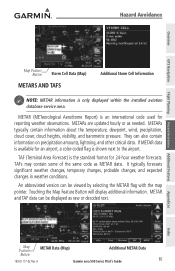
... Data (Map)
METARs and TAFs
Additional Storm Cell Information
NOTE: METAR information is an international code used for 24-hour weather forecasts.
An abbreviated version can be displayed as raw or decoded text. A
Garmin aera 500 Series Pilot's Guide
85
Appendices
Index METAR (METeorological Aerodrome Report) is only displayed within the installed aviation...
Pilot's Guide - Page 119
...AOPA Tab (if necessary). A
Garmin aera 500 Series Pilot's Guide
107
Appendices
Index
190-01117-02 Rev. Overview
GPS Navigation
Flight Planning Hazard Avoidance Additional Features...If duplicate entries exist for instructions on updating the SafeTaxi database.
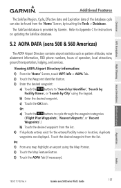
5.2 AOPA Data (aera 500 & 560 Americas)
The AOPA Airport Directory contains airport statistics such as pattern altitudes, ...
Pilot's Guide - Page 139

... to the correct mode, the user must connect the aera to a USB data port.
The Mass Storage Icon appears on in Windows and as removable drives in My Computer in the desired mode (aviation or automotive). Press it in until it is in the
battery compartment. A
Garmin aera 500 Series Pilot's Guide
127
Index
Pilot's Guide - Page 148

... as is practical. 2) When in place. 5) Connect power/data cables. Install the yoke mount as far from the yoke mount: 1) Press the Release Button on the side of the mount to the yoke mount: 1) Fit the bottom of the aera into place. Overview
GPS Navigation
Appendix D
Attaching the yoke mount to hold the...
Pilot's Guide - Page 154
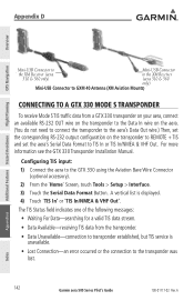
... set the aera's Serial Data Format to TIS In or TIS In/NMEA & VHF Out. Appendix D
Overview
GPS Navigation
Additional Features Hazard Avoidance Flight Planning
Mini-USB Connector to
Mini-USB Connector
the XM Receiver (aera
to the XM Receiver
510 & 560 only)
(aera 510 & 560
only)
Mini-USB Connector to GXM 40 Antenna (XM Aviation Mounts)
Connecting...
Pilot's Guide - Page 156
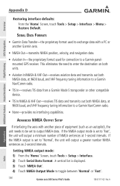
... enter the destination on both units.
• Aviation In/NMEA & VHF Out-receives aviation data and transmits out both NMEA data, at 9600 baud, and VHF frequency tuning information to toggle between 'Normal' or 'Fast'.
144
Garmin aera 500 Series Pilot's Guide
190-01117-02 Rev. Appendix D
Overview
GPS Navigation
Additional Features Hazard Avoidance Flight Planning...
Similar Questions

On My Garmin Area 560 I Turn On My Gps And Garmin Comes Up On The Screen But
The gps screens donot open What is wrong
The gps screens donot open What is wrong
(Posted by Stevehorychun 3 years ago)

650 Beeps When 560 Removed From Panel
As soon as I removed the 560 from the panel to send it in for repairs, the gtn 650 started beeping. ...
As soon as I removed the 560 from the panel to send it in for repairs, the gtn 650 started beeping. ...
(Posted by Jeffspencer 6 years ago)


Reset Aera 500
hi! i have problem with my AERA 500. i Can´t start it. haw can i reset it? thank you
hi! i have problem with my AERA 500. i Can´t start it. haw can i reset it? thank you
(Posted by jacarrizo 12 years ago)