
Owner's Manual
Page 4
... 17 Data Fields 18 TRIP COMPUTER 19-20 Data Field Options 20 MENU PAGE 21-33 Menu Navigation 21 Waypoints 22 Mark Waypoint Page 22 Review Waypoint Page 24 Tracks 26 Routes 29 Games 32 SETUP PAGE 34-44 Time Page 34 Time Zone 34 Daylight Savings Time 35 Display 36... Timeout 36 Contrast 36 Units 37 Position Format 37 Map Datums 37 Units of Measure 38 Interface 39 Heading 40 North Reference 40 System 42 GPS Mode 42 Compass Setting 43 Altimeter Setting 43 Battery Setting 43 Languages 44 Owner Info 44 APPENDICES 45-47 Appendix A: Specifications 45 Appendix...
... 17 Data Fields 18 TRIP COMPUTER 19-20 Data Field Options 20 MENU PAGE 21-33 Menu Navigation 21 Waypoints 22 Mark Waypoint Page 22 Review Waypoint Page 24 Tracks 26 Routes 29 Games 32 SETUP PAGE 34-44 Time Page 34 Time Zone 34 Daylight Savings Time 35 Display 36... Timeout 36 Contrast 36 Units 37 Position Format 37 Map Datums 37 Units of Measure 38 Interface 39 Heading 40 North Reference 40 System 42 GPS Mode 42 Compass Setting 43 Altimeter Setting 43 Battery Setting 43 Languages 44 Owner Info 44 APPENDICES 45-47 Appendix A: Specifications 45 Appendix...
Owner's Manual
Page 6
...AID AND MUST NOT BE USED FOR ANY PURPOSE REQUIRING PRECISE MEASUREMENT OF DIRECTION, DISTANCE, LOCATION OR TOPOGRAPHY. Although the Garmin GPS receiver is a precision electronic NAVigation AID (NAVAID), any discrepancies before continuing navigation. It is in a safe manner, maintain ... GROUND PROXIMITY FOR AIRCRAFT NAVIGATION. Introduction Warnings and Cautions , iv CAUTION: Use the Geko 301 at all GPS equipment. To reduce the risk of unsafe operation, carefully review and understand all available navigation sources, including the information from other NAVAIDs, visual sightings,...
...AID AND MUST NOT BE USED FOR ANY PURPOSE REQUIRING PRECISE MEASUREMENT OF DIRECTION, DISTANCE, LOCATION OR TOPOGRAPHY. Although the Garmin GPS receiver is a precision electronic NAVigation AID (NAVAID), any discrepancies before continuing navigation. It is in a safe manner, maintain ... GROUND PROXIMITY FOR AIRCRAFT NAVIGATION. Introduction Warnings and Cautions , iv CAUTION: Use the Geko 301 at all GPS equipment. To reduce the risk of unsafe operation, carefully review and understand all available navigation sources, including the information from other NAVAIDs, visual sightings,...
Owner's Manual
Page 34
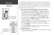
... 'MARK' highlighted, press the OK Button to accept the waypoint. 2. Use the UP or DOWN Button to scroll through the position coordinate places using the Review Waypoint Page. Press the UP or DOWN Button to highlight the 'OK' field and press the OK Button to store your current location or...
... 'MARK' highlighted, press the OK Button to accept the waypoint. 2. Use the UP or DOWN Button to scroll through the position coordinate places using the Review Waypoint Page. Press the UP or DOWN Button to highlight the 'OK' field and press the OK Button to store your current location or...
Owner's Manual
Page 35
... press the OK Button to finish making changes. 4. To select a waypoint: 1. Repeat to display the REVIEW WAYPOINT Page. Press the UP or DOWN Button to highlight the waypoint on any Page to display the REVIEW WAYPOINT Page. To delete all Waypoints. 3. Press the UP or DOWN Button to highlight the 'ELEV...
... press the OK Button to finish making changes. 4. To select a waypoint: 1. Repeat to display the REVIEW WAYPOINT Page. Press the UP or DOWN Button to highlight the waypoint on any Page to display the REVIEW WAYPOINT Page. To delete all Waypoints. 3. Press the UP or DOWN Button to highlight the 'ELEV...
Owner's Manual
Page 36
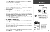
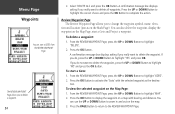
... on a map with the selected waypoint as on the Map Page: 1. To start a GOTO from the REVIEW WAYPOINT Page. tion. Press the OK Button to complete the action. Review Waypoint Page The Review Waypoint Page allows you really want to change the waypoint symbol, name, eleva- tion and location (just as...to zoom in and out on the Map Page, start a Goto and Project a waypoint. To view the selected waypoint on the Mark Page). The REVIEW WAYPOINT Page allows you really want to delete the waypoint, press the UP or DOWN Button to highlight 'YES' and press OK. You can also...
... on a map with the selected waypoint as on the Map Page: 1. To start a GOTO from the REVIEW WAYPOINT Page. tion. Press the OK Button to complete the action. Review Waypoint Page The Review Waypoint Page allows you really want to change the waypoint symbol, name, eleva- tion and location (just as...to zoom in and out on the Map Page, start a Goto and Project a waypoint. To view the selected waypoint on the Mark Page). The REVIEW WAYPOINT Page allows you really want to delete the waypoint, press the UP or DOWN Button to highlight 'YES' and press OK. You can also...
Owner's Manual
Page 37
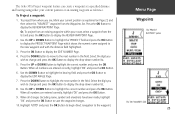
...route, select a waypoint from the list and press the OK Button to display the EDIT NUMBER Page. 4. Press the OK Button to display the REVIEW WAYPOINT Page. 2. Highlight 'GOTO' and press the OK Button to begin direct navigation to the next number in the field. Menu Page.... Press the OK Button to highlight the correct number and press the OK Button. Use the UP or DOWN Button to display the REVIEW WAYPOINT Page. The Geko 301's Project waypoint feature can create a waypoint at a specified distance and bearing using either your current position as reference. To ...
...route, select a waypoint from the list and press the OK Button to display the EDIT NUMBER Page. 4. Press the OK Button to display the REVIEW WAYPOINT Page. 2. Highlight 'GOTO' and press the OK Button to begin direct navigation to the next number in the field. Menu Page.... Press the OK Button to highlight the correct number and press the OK Button. Use the UP or DOWN Button to display the REVIEW WAYPOINT Page. The Geko 301's Project waypoint feature can create a waypoint at a specified distance and bearing using either your current position as reference. To ...
Owner's Manual
Page 64
Index 52 Profile Field 15 Projecting a Waypoint 25 R Registration i Reset 16 Review Waypoint Page 24 Routes 29-31 RTCM/NMEA 39 RTCM/TEXT 39 RTCM IN 39 S Satellite Page 3-6 Select a Waypoint 23 Settings Input 39 Set course ... 45 Speed 12, 20 Maximum 20 (Speed cont.) Overall 20 Vertical 20 Stopped Time 20 Stop Navigation 8 Storage viii Sunrise 20 Sunset 20 System Page GPS Mode 42, 43 Owner Info 44 T TEXT OUT 39 Time Moving 20 Of Day 20 Stopped 20 Total 20 Time/Date 12 Time Page 34...
Index 52 Profile Field 15 Projecting a Waypoint 25 R Registration i Reset 16 Review Waypoint Page 24 Routes 29-31 RTCM/NMEA 39 RTCM/TEXT 39 RTCM IN 39 S Satellite Page 3-6 Select a Waypoint 23 Settings Input 39 Set course ... 45 Speed 12, 20 Maximum 20 (Speed cont.) Overall 20 Vertical 20 Stopped Time 20 Stop Navigation 8 Storage viii Sunrise 20 Sunset 20 System Page GPS Mode 42, 43 Owner Info 44 T TEXT OUT 39 Time Moving 20 Of Day 20 Stopped 20 Total 20 Time/Date 12 Time Page 34...