

Owner's Manual
Page 5
...86 Specifications 86 Installing the GPSMAP 492/498 External GPS Antenna..... 87 Mounting the GPSMAP 392/398/492/498 88 Installing the Transducer 90 Connecting the Power/Data Cable 92 Interfacing 93 Installing and Removing Data Cards 94 Satellite Information 95 INTRODUCTION > TABLE OF ... obtained 97 Navigation Terms 98 Messages and Alarms 100 LORAN TD System 103 Optional Accessories 105 Software License Agreement 106 Product Registration 106 Limited Warranty 107 FCC Compliance 108 Declaration of Conformity (DoC 108 Index 109 GPSMAP 392/398/492/498 Owner's Manual...
...86 Specifications 86 Installing the GPSMAP 492/498 External GPS Antenna..... 87 Mounting the GPSMAP 392/398/492/498 88 Installing the Transducer 90 Connecting the Power/Data Cable 92 Interfacing 93 Installing and Removing Data Cards 94 Satellite Information 95 INTRODUCTION > TABLE OF ... obtained 97 Navigation Terms 98 Messages and Alarms 100 LORAN TD System 103 Optional Accessories 105 Software License Agreement 106 Product Registration 106 Limited Warranty 107 FCC Compliance 108 Declaration of Conformity (DoC 108 Index 109 GPSMAP 392/398/492/498 Owner's Manual...

Owner's Manual
Page 9
... of the sky. To turn off the GPSMAP 392/398/492/498: 1. The GPS Information Page appears as the receiver begins acquiring satellites. GPSMAP 392/398/492/498 Owner's Manual BASIC OPERATION > INITIALIZING THE RECEIVER 3. To turn on the GPSMAP 392/398/492/498: 1. Press ENTER to answer NO to collect satellite data and establish its present location. Press...
... of the sky. To turn off the GPSMAP 392/398/492/498: 1. The GPS Information Page appears as the receiver begins acquiring satellites. GPSMAP 392/398/492/498 Owner's Manual BASIC OPERATION > INITIALIZING THE RECEIVER 3. To turn on the GPSMAP 392/398/492/498: 1. Press ENTER to answer NO to collect satellite data and establish its present location. Press...
Owner's Manual
Page 10
... up or down on the bottom of the screen shows either "Ready for Navigation", and the GPSMAP 392/398/492/498 is ready for the satellites indicated. • Hollow signal strength bars-the receiver has found the indicated satellite(s) and is collecting data. • Solid signal strength bars-the receiver is... Down key to use . 2 GPSMAP 392/398/492/498 Owner's Manual Using the ROCKER, highlight Initialize Position, and press ENTER. NOTE: This does not calibrate the unit in view appears on the ROCKER until the GPS tab is looking for use . When viewing the GPS tab on the Main Menu, a...
... up or down on the bottom of the screen shows either "Ready for Navigation", and the GPSMAP 392/398/492/498 is ready for the satellites indicated. • Hollow signal strength bars-the receiver has found the indicated satellite(s) and is collecting data. • Solid signal strength bars-the receiver is... Down key to use . 2 GPSMAP 392/398/492/498 Owner's Manual Using the ROCKER, highlight Initialize Position, and press ENTER. NOTE: This does not calibrate the unit in view appears on the ROCKER until the GPS tab is looking for use . When viewing the GPS tab on the Main Menu, a...

Owner's Manual
Page 11
When the unit is retained in memory for actual navigation. GPSMAP 392/398/492/498 Owner's Manual 3 Use the ROCKER to navigate using Simulator Mode. WARNING: Do not attempt to highlight the GPS tab, and then press ADJ/MENU once. 2. All the waypoint and route planning completed in Simulator ... to confirm the Running Simulator message that the GPSMAP 392/398/492/498 does not track satellites in mind that appears at the top of each of actual satellite signals. Use the ROCKER to Simulator Mode, the GPS receiver is turned on, "Simulating" appears at the bottom...
When the unit is retained in memory for actual navigation. GPSMAP 392/398/492/498 Owner's Manual 3 Use the ROCKER to navigate using Simulator Mode. WARNING: Do not attempt to highlight the GPS tab, and then press ADJ/MENU once. 2. All the waypoint and route planning completed in Simulator ... to confirm the Running Simulator message that the GPSMAP 392/398/492/498 does not track satellites in mind that appears at the top of each of actual satellite signals. Use the ROCKER to Simulator Mode, the GPS receiver is turned on, "Simulating" appears at the bottom...
Owner's Manual
Page 16
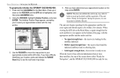
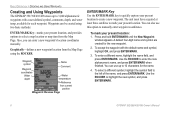
...You can use this option to mark your present location to create a new waypoint. The unit must have acquired at least three satellites to manually enter waypoint coordinates. Press and hold ENTER/MARK until the New Waypoint window appears. Use the ROCKER to enter the new... two basic methods: ENTER/MARK Key-marks your present location: 1. BASIC OPERATION > CREATING AND USING WAYPOINTS Creating and Using Waypoints The GPSMAP 392/398/492/498 stores up to 10 characters for the name. 4. Waypoints can enter a new waypoint's location coordinates manually. A default four-digit name...
...You can use this option to mark your present location to create a new waypoint. The unit must have acquired at least three satellites to manually enter waypoint coordinates. Press and hold ENTER/MARK until the New Waypoint window appears. Use the ROCKER to enter the new... two basic methods: ENTER/MARK Key-marks your present location: 1. BASIC OPERATION > CREATING AND USING WAYPOINTS Creating and Using Waypoints The GPSMAP 392/398/492/498 stores up to 10 characters for the name. 4. Waypoints can enter a new waypoint's location coordinates manually. A default four-digit name...

Owner's Manual
Page 24
For best performance, keep the interval set to Resolution. • If the receiver is turned off or satellite coverage is set to the Time option, the route can only use this function with fewer changes in order to follow your track, and simpli&#... A DESTINATION To start a TracBack using the NAV key: 1. Press NAV, highlight TracBack, and press ENTER. 2. To stop Follow Track navigation, press NAV, highlight Stop Navigation, and press ENTER. 16 GPSMAP 392/398/492/498 Owner's Manual Up to the most significant points of your exact path. For more information on page 15...
For best performance, keep the interval set to Resolution. • If the receiver is turned off or satellite coverage is set to the Time option, the route can only use this function with fewer changes in order to follow your track, and simpli&#... A DESTINATION To start a TracBack using the NAV key: 1. Press NAV, highlight TracBack, and press ENTER. 2. To stop Follow Track navigation, press NAV, highlight Stop Navigation, and press ENTER. 16 GPSMAP 392/398/492/498 Owner's Manual Up to the most significant points of your exact path. For more information on page 15...
Owner's Manual
Page 45
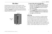
...on the ROCKER to select any given moment. GPSMAP 392/398/492/498 Owner's Manual 37 Sub tabs Main menu tabs Main Menu MAIN MENU > GPS TAB To select a Menu tab from any page in view. If you an indication of satellite acquisition, receiver status, and accuracy. Press up ...or down on the ROCKER, then press up or down to the receiver and whether or not they are divided into categories by pressing and holding ADJ/MENU. Press QUIT to various waypoint, system, navigation, interface management...
...on the ROCKER to select any given moment. GPSMAP 392/398/492/498 Owner's Manual 37 Sub tabs Main menu tabs Main Menu MAIN MENU > GPS TAB To select a Menu tab from any page in view. If you an indication of satellite acquisition, receiver status, and accuracy. Press up ...or down on the ROCKER, then press up or down to the receiver and whether or not they are divided into categories by pressing and holding ADJ/MENU. Press QUIT to various waypoint, system, navigation, interface management...
Owner's Manual
Page 46
... is now being calculated in Simulator Mode. 38 GPSMAP 392/398/492/498 Owner's Manual MAIN MENU > GPS TAB Accuracy Receiver status WAAS status Signal strength bars The status field indicates "Ready for Navigation" when the GPSMAP 392/398/492/498 has collected the necessary data from satellites visible at least three satellites have a current location fix.
... is now being calculated in Simulator Mode. 38 GPSMAP 392/398/492/498 Owner's Manual MAIN MENU > GPS TAB Accuracy Receiver status WAAS status Signal strength bars The status field indicates "Ready for Navigation" when the GPSMAP 392/398/492/498 has collected the necessary data from satellites visible at least three satellites have a current location fix.
Owner's Manual
Page 95
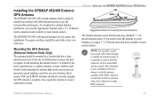
...the best possible performance. To acquire satellites, install the unit with harsh solvents. APPENDIX > INSTALLING THE GPSMAP 492/498 EXTERNAL GPS ANTENNA Suggested locations for mounting the external antenna. The GPSMAP 492/498 with internal antennas do not require ...GPSMAP 492/498 External GPS Antenna The GPSMAP 492/498 with external antenna must be replaced with a new solder-on or crimp BNC connector. To complete the external antenna installation, you need the appropriate fasteners and a 1" x 14-thread marine antenna mount available at most marine dealers. The Garmin...
...the best possible performance. To acquire satellites, install the unit with harsh solvents. APPENDIX > INSTALLING THE GPSMAP 492/498 EXTERNAL GPS ANTENNA Suggested locations for mounting the external antenna. The GPSMAP 492/498 with internal antennas do not require ...GPSMAP 492/498 External GPS Antenna The GPSMAP 492/498 with external antenna must be replaced with a new solder-on or crimp BNC connector. To complete the external antenna installation, you need the appropriate fasteners and a 1" x 14-thread marine antenna mount available at most marine dealers. The Garmin...
Owner's Manual
Page 103
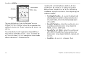
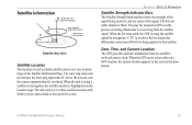
...or filled. Date, Time, and Current Location The GPS gets date and time information from the satellite signal. When the bar turns solid, the GPS is using a satellite for navigation. When the GPS receiver has achieved a GPS location, the current location appears in the process of storing orbital... Outer ring the horizon 45° Satellite Sky View Satellite Location The location of the signal being applied to show the strength of each available satellite shows over two location rings on the Satellite Information Page. GPSMAP 392/398/492/498 Owner's Manual 95 The unit can ...
...or filled. Date, Time, and Current Location The GPS gets date and time information from the satellite signal. When the bar turns solid, the GPS is using a satellite for navigation. When the GPS receiver has achieved a GPS location, the current location appears in the process of storing orbital... Outer ring the horizon 45° Satellite Sky View Satellite Location The location of the signal being applied to show the strength of each available satellite shows over two location rings on the Satellite Information Page. GPSMAP 392/398/492/498 Owner's Manual 95 The unit can ...
Owner's Manual
Page 104
... stations, located on your GPSMAP 392/398/492/498 in September 2002 confirmed an accuracy performance of 1-2 meters horizontal and 2-3 meters vertical throughout the majority of the continental United States and portions of providing your Garmin GPS receiver, the receiver automatically uses the method that provided by GPS satellites alone. According to less than...
... stations, located on your GPSMAP 392/398/492/498 in September 2002 confirmed an accuracy performance of 1-2 meters horizontal and 2-3 meters vertical throughout the majority of the continental United States and portions of providing your Garmin GPS receiver, the receiver automatically uses the method that provided by GPS satellites alone. According to less than...
Owner's Manual
Page 106
...ETA (Estimate Time of Arrival)-the time you estimate to reach your current location to a destination. GPS Accuracy-estimated accuracy of the GPS signals and satellite geometry. GPSMAP 392/398/492/498 Owner's Manual This field is active only if a transducer is moving . Dist to Destination-...-by -second position readings. Course-the course between two route waypoints. Elevation-height above mean sea level (MSL). APPENDIX > NAVIGATION TERMS Navigation Terms Avg Speed-the average of distance travelled, based on current speed and track. 98 ETA at Next-the time you estimate...
...ETA (Estimate Time of Arrival)-the time you estimate to reach your current location to a destination. GPS Accuracy-estimated accuracy of the GPS signals and satellite geometry. GPSMAP 392/398/492/498 Owner's Manual This field is active only if a transducer is moving . Dist to Destination-...-by -second position readings. Course-the course between two route waypoints. Elevation-height above mean sea level (MSL). APPENDIX > NAVIGATION TERMS Navigation Terms Avg Speed-the average of distance travelled, based on current speed and track. 98 ETA at Next-the time you estimate...
Owner's Manual
Page 109
...more than 300 waypoints and was truncated to a location with the unit. GPSMAP 392/398/492/498 Owner's Manual 101 NMEA Depth Is Below Transducer-you entered the alarm ... Failed, Unit Needs Repair-there is in the "Off Course" alarm. Lost Satellite Reception-the unit has lost satellite signals. Proximity Alarm-you used all available proximity waypoints. Fish Alarm (not a...beep sounds (if enabled) when a fish is detected. Contact your dealer or Garmin Product Support to transfer user data from another proximity waypoint. Proximity Overlaps Another Proximity Waypoint-...
...more than 300 waypoints and was truncated to a location with the unit. GPSMAP 392/398/492/498 Owner's Manual 101 NMEA Depth Is Below Transducer-you entered the alarm ... Failed, Unit Needs Repair-there is in the "Off Course" alarm. Lost Satellite Reception-the unit has lost satellite signals. Proximity Alarm-you used all available proximity waypoints. Fish Alarm (not a...beep sounds (if enabled) when a fish is detected. Contact your dealer or Garmin Product Support to transfer user data from another proximity waypoint. Proximity Overlaps Another Proximity Waypoint-...

Owner's Manual
Page 118
... 97 MOB 10 N narrow beam 72 NAV/MOB Key 5, 12 navaids 63 navigating 12 distress call 24 Go To 13 position report 24 routes 18 TracBack 14 navigation terms 98 NMEA 70 north up 62 O off course alarm 71 orientation 62 Out... 17 copy 51 create 17 delete 51 delete all 51 routes tab 51 route review page 52 options 53 S satellite location 95 satellite sky view 95 scroll speed 80 selecting options 6 shallow/deep water alarm 71 simulator mode 3 software update card ... 65 T temperature 82 temperature graph 77 temperature scale 64 temperature tab 63 thermoclines 83 GPSMAP 392/398/492/498 Owner's Manual
... 97 MOB 10 N narrow beam 72 NAV/MOB Key 5, 12 navaids 63 navigating 12 distress call 24 Go To 13 position report 24 routes 18 TracBack 14 navigation terms 98 NMEA 70 north up 62 O off course alarm 71 orientation 62 Out... 17 copy 51 create 17 delete 51 delete all 51 routes tab 51 route review page 52 options 53 S satellite location 95 satellite sky view 95 scroll speed 80 selecting options 6 shallow/deep water alarm 71 simulator mode 3 software update card ... 65 T temperature 82 temperature graph 77 temperature scale 64 temperature tab 63 thermoclines 83 GPSMAP 392/398/492/498 Owner's Manual
