

Owner's Manual
Page 2
... a hard drive or other Garmin products. Garmin hereby grants permission to change without the express permission of such changes or improvements. GPSMAP®, AutoLocate®, TracBack®, BlueChart®, and MapSource® are trademarks of Garmin Ltd. Garmin Corporation Liberty House No. 68...storage medium, for current updates and supplemental information concerning the use and operation of this document is strictly prohibited. © 2004-2007 Garmin Ltd. Information in the content without obligation to be used without notice. Garmin reserves the right to change...
... a hard drive or other Garmin products. Garmin hereby grants permission to change without the express permission of such changes or improvements. GPSMAP®, AutoLocate®, TracBack®, BlueChart®, and MapSource® are trademarks of Garmin Ltd. Garmin Corporation Liberty House No. 68...storage medium, for current updates and supplemental information concerning the use and operation of this document is strictly prohibited. © 2004-2007 Garmin Ltd. Information in the content without obligation to be used without notice. Garmin reserves the right to change...
Owner's Manual
Page 22
... the simulated speed. Press PAGE or QUIT to the Map Page. The GPSMAP 96 accepts 22MB, while the GPSMAP 96C accepts 118MB of the aircraft symbol as VORDME, TACAN, and VORTAC). The update program is provided from the Jeppesen database: Airport-* identifier, facility name, city... identifier, facility name, city/state/country, position (latitude/longitude), and frequency. 14 96/96C Owner's Manual Press up to the Jeppesen database are available every 28 days online (www.garmin.com). The Jeppesen database provides position and facility information for up on the magenta route line...
... the simulated speed. Press PAGE or QUIT to the Map Page. The GPSMAP 96 accepts 22MB, while the GPSMAP 96C accepts 118MB of the aircraft symbol as VORDME, TACAN, and VORTAC). The update program is provided from the Jeppesen database: Airport-* identifier, facility name, city... identifier, facility name, city/state/country, position (latitude/longitude), and frequency. 14 96/96C Owner's Manual Press up to the Jeppesen database are available every 28 days online (www.garmin.com). The Jeppesen database provides position and facility information for up on the magenta route line...
Owner's Manual
Page 76
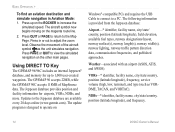
... middle of the page features a rotating Pointer ring that shows your course over ground (track) while you are moving for land navigation. 96/96C Owner's Manual The Marine Mode is indicated at the top of the Pointer ring. 68 Configurable data fields at a glance, the direction of...of your movement and the direction to your destination (bearing) relative to the course is in Automotive or Marine Mode, use PAGE to accurately update and show helpful information during active navigation. Note: You must be selected from the Marine Mode Options Menu. Pointer Page (Automotive Mode) ...
... middle of the page features a rotating Pointer ring that shows your course over ground (track) while you are moving for land navigation. 96/96C Owner's Manual The Marine Mode is indicated at the top of the Pointer ring. 68 Configurable data fields at a glance, the direction of...of your movement and the direction to your destination (bearing) relative to the course is in Automotive or Marine Mode, use PAGE to accurately update and show helpful information during active navigation. Note: You must be selected from the Marine Mode Options Menu. Pointer Page (Automotive Mode) ...

Owner's Manual
Page 78
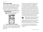
...Aviation and Marine Modes) Adjusts the CDI scale. The Course Pointer, which shows how far off you navigate a route, the turn list automatically updates to indicate the next turn , the street name, and estimated time to choose text size and number of arrival. The current destination point, the...Appendix for data descriptions. Change Data Fields-allows you have started a route in the GPSMAP 96/96C set in each data field on course. Active Route Page Whenever you navigate a route, the list automatically updates to the turn at the top of the same features and options. As you have...
...Aviation and Marine Modes) Adjusts the CDI scale. The Course Pointer, which shows how far off you navigate a route, the turn list automatically updates to indicate the next turn , the street name, and estimated time to choose text size and number of arrival. The current destination point, the...Appendix for data descriptions. Change Data Fields-allows you have started a route in the GPSMAP 96/96C set in each data field on course. Active Route Page Whenever you navigate a route, the list automatically updates to the turn at the top of the same features and options. As you have...
Owner's Manual
Page 105
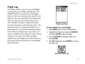
...the airport. (Touchand-goes or brief stops of altitude. Highlight the Flights icon using the ROCKER, and press ENTER to the Flight Log. 96/96C Owner's Manual Selected Flight Log 97 With OK highlighted, press ENTER to return to open the Main Menu. 2. Entries on this list are automatically... flight time. If you land and groundspeed drops below 30 knots, the flight entry is saved and a new entry is continuously updated as the departure airport. The GPSMAP 96/96C saves up to open the page. 3. Press MENU twice to 50 recorded flights. Flight Log The Flight Log shows a list of...
...the airport. (Touchand-goes or brief stops of altitude. Highlight the Flights icon using the ROCKER, and press ENTER to the Flight Log. 96/96C Owner's Manual Selected Flight Log 97 With OK highlighted, press ENTER to return to open the Main Menu. 2. Entries on this list are automatically... flight time. If you land and groundspeed drops below 30 knots, the flight entry is saved and a new entry is continuously updated as the departure airport. The GPSMAP 96/96C saves up to open the page. 3. Press MENU twice to 50 recorded flights. Flight Log The Flight Log shows a list of...
Owner's Manual
Page 120
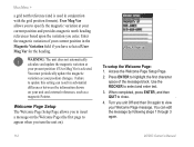
... the first character space of your current position in conjunction with the grid position formats). You must periodically update the magnetic variation as a magnetic Pointer. Failure to select and enter text. 3. Turn you have selected... User Mag Var for the heading. WARNING: The unit does not automatically calculate and update the magnetic variation at your present position if User Mag Var is used in the Magnetic Variation ... the Welcome Page Setup Page. 2. Use the ROCKER to update this setting can edit the message by following steps 1 through 3 again. 112 96...
... the first character space of your current position in conjunction with the grid position formats). You must periodically update the magnetic variation as a magnetic Pointer. Failure to select and enter text. 3. Turn you have selected... User Mag Var for the heading. WARNING: The unit does not automatically calculate and update the magnetic variation at your present position if User Mag Var is used in the Magnetic Variation ... the Welcome Page Setup Page. 2. Use the ROCKER to update this setting can edit the message by following steps 1 through 3 again. 112 96...
Owner's Manual
Page 131
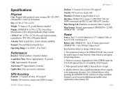
... DoD imposed Selective Availability (SA) Program. 3. The temperature rating of the GPSMAP 96/96C may exceed the usable range of their capacity as the temperature decreases. With optional Garmin GBR 21 Beacon Receiver input. 4. Up to 40 hours (typical use)4 ...GPSMAP 96/96C in quad helix, remote antenna capability Keypad: Nine multifunction backlit keys Operating Range: 5 to 158oF (-15 to 70oC)1 Performance Receiver: WAAS enabled, 12 parallel channel Acquisition Time: Warm: Approximately 15 seconds Cold: Approximately 45 seconds AutoLocate™: Approximately 2 minutes Update...
... DoD imposed Selective Availability (SA) Program. 3. The temperature rating of the GPSMAP 96/96C may exceed the usable range of their capacity as the temperature decreases. With optional Garmin GBR 21 Beacon Receiver input. 4. Up to 40 hours (typical use)4 ...GPSMAP 96/96C in quad helix, remote antenna capability Keypad: Nine multifunction backlit keys Operating Range: 5 to 158oF (-15 to 70oC)1 Performance Receiver: WAAS enabled, 12 parallel channel Acquisition Time: Warm: Approximately 15 seconds Cold: Approximately 45 seconds AutoLocate™: Approximately 2 minutes Update...

Owner's Manual
Page 150
or its subsidiaries Garmin International, Inc. 1200 East 151st Street, Olathe, Kansas 66062, USA Garmin (Europe) Ltd. Liberty House, Hounsdown Business Park, Southampton, Hampshire, SO40 9RB UK Garmin Corporation No. 68, Jangshu 2nd Road, Shijr, Taipei County, Taiwan www.garmin.com Part Number 190-00420-00 Rev. C For the latest free software updates (excluding map data) throughout the life of your Garmin products, visit the Garmin Web site at www.garmin.com. © 2004-2007 Garmin Ltd.
or its subsidiaries Garmin International, Inc. 1200 East 151st Street, Olathe, Kansas 66062, USA Garmin (Europe) Ltd. Liberty House, Hounsdown Business Park, Southampton, Hampshire, SO40 9RB UK Garmin Corporation No. 68, Jangshu 2nd Road, Shijr, Taipei County, Taiwan www.garmin.com Part Number 190-00420-00 Rev. C For the latest free software updates (excluding map data) throughout the life of your Garmin products, visit the Garmin Web site at www.garmin.com. © 2004-2007 Garmin Ltd.


