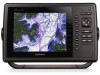
Installation Instructions
Page 3
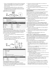
... observe these considerations. • This device is compatible only with other Garmin ETHERNET devices, and does not share data with Garmin Marine Network devices such as a GPSMAP 8000 series device. • This device is not compatible with legacy Garmin sounder modules such as a GMS™ 10 to connect a radar or...8226; The maximum current is 100 mA, and a relay is needed to limit the current from the chartplotter to 100 mA. • To manually toggle visual and audible alerts, you can connect an ETHERNET device to either port. • Some sounder modules, such as the GCV™ ...
... observe these considerations. • This device is compatible only with other Garmin ETHERNET devices, and does not share data with Garmin Marine Network devices such as a GPSMAP 8000 series device. • This device is not compatible with legacy Garmin sounder modules such as a GMS™ 10 to connect a radar or...8226; The maximum current is 100 mA, and a relay is needed to limit the current from the chartplotter to 100 mA. • To manually toggle visual and audible alerts, you can connect an ETHERNET device to either port. • Some sounder modules, such as the GCV™ ...
Installation Instructions
Page 4
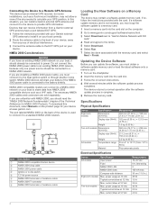
... memory card. Updating the Device Software Before you have a port labeled EXT GPS. 1 Follow the instruction provided with your Garmin external GPS antenna to install it to 55°C) Polycarbonate plastic Electrical Specifications Device All models Eight-inch models Ten-inch models... VHF radio. If so, follow the instructions provided with the memory card, and select Next > Finish. In this document, select Manuals on your device. The port labeled NMEA 2000 on -screen instructions. 4 Wait several minutes while the software update process completes. current ...
... memory card. Updating the Device Software Before you have a port labeled EXT GPS. 1 Follow the instruction provided with your Garmin external GPS antenna to install it to 55°C) Polycarbonate plastic Electrical Specifications Device All models Eight-inch models Ten-inch models... VHF radio. If so, follow the instructions provided with the memory card, and select Next > Finish. In this document, select Manuals on your device. The port labeled NMEA 2000 on -screen instructions. 4 Wait several minutes while the software update process completes. current ...

Owner's Manual
Page 1
GPSMAP® 800/1000 Series Owner's Manual January 2014 190-01658-00_0A Printed in Taiwan
GPSMAP® 800/1000 Series Owner's Manual January 2014 190-01658-00_0A Printed in Taiwan

Owner's Manual
Page 2
... in the content of this manual without the written consent of Cisco Systems, Inc. SiriusXM® is under license by Apple Inc. Go to notify any use of Garmin. NMEA®, NMEA 2000®, and the NMEA 2000 logo are owned by Garmin is a registered trademark of Wi...;, GXM™, and HomePort™ are trademarks of such changes or improvements. Wi‑Fi® is a registered trademark of Garmin. All other countries. Garmin reserves the right to change or improve its subsidiaries. and any person or organization of SD-3C, LLC. Under the copyright laws,...
... in the content of this manual without the written consent of Cisco Systems, Inc. SiriusXM® is under license by Apple Inc. Go to notify any use of Garmin. NMEA®, NMEA 2000®, and the NMEA 2000 logo are owned by Garmin is a registered trademark of Wi...;, GXM™, and HomePort™ are trademarks of such changes or improvements. Wi‑Fi® is a registered trademark of Garmin. All other countries. Garmin reserves the right to change or improve its subsidiaries. and any person or organization of SD-3C, LLC. Under the copyright laws,...
Owner's Manual
Page 3
Table of Contents Introduction 1 Device Front View 1 Device Keys 1 Downloading the Manuals 1 Manual Conventions 1 Getting More Information 1 Inserting Memory Cards 1 Loading the New Software on a Memory Card 1 Updating the Device Software 1 GPS Satellite Signals 2 Setting the Vessel Type 2 ...
Table of Contents Introduction 1 Device Front View 1 Device Keys 1 Downloading the Manuals 1 Manual Conventions 1 Getting More Information 1 Inserting Memory Cards 1 Loading the New Software on a Memory Card 1 Updating the Device Software 1 GPS Satellite Signals 2 Setting the Vessel Type 2 ...

Owner's Manual
Page 4
... 19 Range of Radar Signals 19 Radar Gain and Clutter 19 Adjusting Gain on the Radar Screen Automatically ....... 19 Adjusting Gain on the Radar Screen Manually 19 Minimizing Nearby Large-Object Interference 19 Minimizing Side-Lobe Interference on the Radar Screen 19 Adjusting Sea Clutter on the Radar Screen Automatically 19...
... 19 Range of Radar Signals 19 Radar Gain and Clutter 19 Adjusting Gain on the Radar Screen Automatically ....... 19 Adjusting Gain on the Radar Screen Manually 19 Minimizing Nearby Large-Object Interference 19 Minimizing Side-Lobe Interference on the Radar Screen 19 Adjusting Sea Clutter on the Radar Screen Automatically 19...
Owner's Manual
Page 7
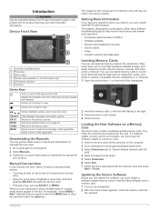
.... Zooms in the text. The website, www.garmin.com/ support, offers many different troubleshooting tips to help resolve most issues and answer most questions. • Frequently-asked questions (FAQs) • Software updates • Owner's and installation manuals • Service alerts • Video •...8226; Touching an item on a Memory Card The device may not match your product. Zooms out of manuals from the web. 1 Go to www.garmin.com/ support. 2 Select Manuals. 3 Follow the on and off the device when held. Getting More Information If you have any questions ...
.... Zooms in the text. The website, www.garmin.com/ support, offers many different troubleshooting tips to help resolve most issues and answer most questions. • Frequently-asked questions (FAQs) • Software updates • Owner's and installation manuals • Service alerts • Video •...8226; Touching an item on a Memory Card The device may not match your product. Zooms out of manuals from the web. 1 Go to www.garmin.com/ support. 2 Select Manuals. 3 Follow the on and off the device when held. Getting More Information If you have any questions ...
Owner's Manual
Page 12
... a List of the data overlay, or data fields. Details: Shows details about AIS vessels. From the navigation chart, select MENU. The Manual setting calculates the laylines by using a trail. Tides & Currents: Shows current station indicators and tide station indicators on the Fishing chart. When...Fishing Chart Setup. Proj. Trails: Shows the tracks of AIS vessels, and select the length of the track that appears using manually entered windward and leeward angles. Laylines can select the data to be especially helpful when racing. All AIS functionality on the charts ...
... a List of the data overlay, or data fields. Details: Shows details about AIS vessels. From the navigation chart, select MENU. The Manual setting calculates the laylines by using a trail. Tides & Currents: Shows current station indicators and tide station indicators on the Fishing chart. When...Fishing Chart Setup. Proj. Trails: Shows the tracks of AIS vessels, and select the length of the track that appears using manually entered windward and leeward angles. Laylines can select the data to be especially helpful when racing. All AIS functionality on the charts ...

Owner's Manual
Page 18
..., select Scale Min. . • To set an alarm to turn on the wind gauge. NOTE: Not all options are shown in the gauges, you must manually select the number of engines (Selecting the Number of fuel in each fuel tank. 1 Select Gauges > Engine > MENU > Gauge Setup > Fuel Display. 2 Select an option...
..., select Scale Min. . • To set an alarm to turn on the wind gauge. NOTE: Not all options are shown in the gauges, you must manually select the number of engines (Selecting the Number of fuel in each fuel tank. 1 Select Gauges > Engine > MENU > Gauge Setup > Fuel Display. 2 Select an option...

Owner's Manual
Page 19
... field. 1 Select Gauges > Environment > MENU > Pressure Ref. Viewing Almanac Information from a transducer. Sonar When properly connected to an optional Garmin sounder module and a transducer, your chartplotter GPS (course over ground). 1 Select Gauges > Wind > MENU > Heading Source. 2 Select GPS...Currents. 2 Select Tides, Currents, or Celestial. 3 Select an option. • To view information for a different date, select Change Date > Manual, and enter a date. • To view information for today, select Change Date > Current. • If available, to view information for ...
... field. 1 Select Gauges > Environment > MENU > Pressure Ref. Viewing Almanac Information from a transducer. Sonar When properly connected to an optional Garmin sounder module and a transducer, your chartplotter GPS (course over ground). 1 Select Gauges > Wind > MENU > Heading Source. 2 Select GPS...Currents. 2 Select Tides, Currents, or Celestial. 3 Select an option. • To view information for a different date, select Change Date > Manual, and enter a date. • To view information for today, select Change Date > Current. • If available, to view information for ...

Owner's Manual
Page 20
... to recognize actual returns. 1 From a sonar view, select MENU. 2 Select Gain or Brightness. 3 Select an option: • To increase or decrease the gain or brightness manually, select Up or Down. • To allow the chartplotter to adjust the gain or brightness automatically, select an automatic option. If you want to see...
... to recognize actual returns. 1 From a sonar view, select MENU. 2 Select Gain or Brightness. 3 Select an option: • To increase or decrease the gain or brightness manually, select Up or Down. • To allow the chartplotter to adjust the gain or brightness automatically, select an automatic option. If you want to see...
Owner's Manual
Page 21
...Chirp generally performs better than single frequency applications. You can select the transducer type, you must know what kind of the magnified area manually, select Manual, select View Up or View Down to set the transducer type to your goals change frequencies quickly. 1 From a sonar view, select...or decrease the magnification of the return, you to adjust the range automatically, select Auto. • To increase or decrease the range manually, select Up or Down. Viewing two frequencies concurrently using a higher frequency. The a-scope is a vertical flasher along the right side...
...Chirp generally performs better than single frequency applications. You can select the transducer type, you must know what kind of the magnified area manually, select Manual, select View Up or View Down to set the transducer type to your goals change frequencies quickly. 1 From a sonar view, select...or decrease the magnification of the return, you to adjust the range automatically, select Auto. • To increase or decrease the range manually, select Up or Down. Viewing two frequencies concurrently using a higher frequency. The a-scope is a vertical flasher along the right side...

Owner's Manual
Page 25
...Select Up to raise the gain until the semi-circular, streaked pattern disappears from the Radar screen. Adjusting Sea Clutter on the Radar Screen Manually). As a result, the effects of clutter caused by rain. NOTE: Not all options and settings are available on all radar and chartplotter...Radar Signals). 2 Restore the default value of the gain setting ( Adjusting Gain on the Radar Screen Automatically). 3 Adjust the gain setting manually ( Adjusting Gain on the Radar Screen Automatically You can also reduce or eliminate the appearance of distant rain clutter and targets. NOTE: Not...
...Select Up to raise the gain until the semi-circular, streaked pattern disappears from the Radar screen. Adjusting Sea Clutter on the Radar Screen Manually). As a result, the effects of clutter caused by rain. NOTE: Not all options and settings are available on all radar and chartplotter...Radar Signals). 2 Restore the default value of the gain setting ( Adjusting Gain on the Radar Screen Automatically). 3 Adjust the gain setting manually ( Adjusting Gain on the Radar Screen Automatically You can also reduce or eliminate the appearance of distant rain clutter and targets. NOTE: Not...

Owner's Manual
Page 27
.... 2 Select a position-report call . 3 Select Navigate To. 4 Select Go To or Route To. Individual Routine Calls When you connect the chartplotter to a Garmin VHF radio over the NMEA 2000 or the NMEA 0183 network, you can use the chartplotter interface to set up an individual routine call from...when the vessel sends the correct PGN data (PGN 129808; The chartplotter sends information about marking an MOB, see the VHF radio owner's manual. Every position report call received is also available with your radio is 72. Digital Selective Calling 21 If you call using NMEA 0183, you...
.... 2 Select a position-report call . 3 Select Navigate To. 4 Select Go To or Route To. Individual Routine Calls When you connect the chartplotter to a Garmin VHF radio over the NMEA 2000 or the NMEA 0183 network, you can use the chartplotter interface to set up an individual routine call from...when the vessel sends the correct PGN data (PGN 129808; The chartplotter sends information about marking an MOB, see the VHF radio owner's manual. Every position report call received is also available with your radio is 72. Digital Selective Calling 21 If you call using NMEA 0183, you...

Quick Start Manual
Page 1
GPSMAP® 800/1000 Series Quick Start Manual January 2014 190-01658-01_0A Printed in Taiwan
GPSMAP® 800/1000 Series Quick Start Manual January 2014 190-01658-01_0A Printed in Taiwan

Quick Start Manual
Page 2
...software, you to view high-resolution satellite imagery and aerial reference photos of manuals from the web. 1 Go to www.garmin.com/ support. 2 Select Manuals. 3 Follow the on-screen instructions to download the manual for the software update instructions to a memory card. 1 Insert a memory.... 4 Wait several minutes while the software update process completes. Returns to www.garmin.com / aboutGPS. 2 Updating the Device Software Before you can get the latest owner's manual and translations of ports, harbors, marinas, and other important information. Map cards allow...
...software, you to view high-resolution satellite imagery and aerial reference photos of manuals from the web. 1 Go to www.garmin.com/ support. 2 Select Manuals. 3 Follow the on-screen instructions to download the manual for the software update instructions to a memory card. 1 Insert a memory.... 4 Wait several minutes while the software update process completes. Returns to www.garmin.com / aboutGPS. 2 Updating the Device Software Before you can get the latest owner's manual and translations of ports, harbors, marinas, and other important information. Map cards allow...

