
Owner's Manual
Page 6
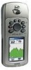
... to navigation and is responsible for safe navigation - GPSmap 76CS Introduction Warnings and Precautions CAUTION: Use the GPSmap® 76CS at your own risk. When in actual use . and, as always, the user is designed to actual use , carefully compare indications from the GPSmap® 76CS to mariners contain all aspects of authorized government charts, not replace...
... to navigation and is responsible for safe navigation - GPSmap 76CS Introduction Warnings and Precautions CAUTION: Use the GPSmap® 76CS at your own risk. When in actual use . and, as always, the user is designed to actual use , carefully compare indications from the GPSmap® 76CS to mariners contain all aspects of authorized government charts, not replace...

Owner's Manual
Page 9
... Page 26Using Time Setup 66 Units Setup 66 Heading Setup 67 Calibration Setup 67 Altimeter Setup 68 Welcome Page Setup 69 ..... GPSmap 76CS Introduction Table of Contents Section 1: Introduction i-iv Waypoints 27 Preface i Using Find 31 Software License Agreement ii The Main Menu... 2: Getting Started 1-7 Battery Installation and Start Up 1 Key Functions 2 Unit Features 3 Initialization 4 The Satellite Page 4 Navigating with the GPSmap 76CS 5 The Main Page Sequence 6 The Main Page Features 7 The Setup Menu 57 System Setup 57 Display Setup 58 Interface Setup 58 Tones...
... Page 26Using Time Setup 66 Units Setup 66 Heading Setup 67 Calibration Setup 67 Altimeter Setup 68 Welcome Page Setup 69 ..... GPSmap 76CS Introduction Table of Contents Section 1: Introduction i-iv Waypoints 27 Preface i Using Find 31 Software License Agreement ii The Main Menu... 2: Getting Started 1-7 Battery Installation and Start Up 1 Key Functions 2 Unit Features 3 Initialization 4 The Satellite Page 4 Navigating with the GPSmap 76CS 5 The Main Page Sequence 6 The Main Page Features 7 The Setup Menu 57 System Setup 57 Display Setup 58 Interface Setup 58 Tones...
Owner's Manual
Page 41
... a list of 50 last found items of Interest, Addresses and Intersections. If you have downloaded Garmin MapSource mapping data that contains additional map detail, you have saved. You can find Marine Points such as Food and Drink, Lodging, etc.). If you download BlueChart® data, you... can also find Waypoint and Geocache Points you can effectively shorten your current location or the Panning Arrow (if active). • To save effort in the GPSmap 76CS basemap. If...
... a list of 50 last found items of Interest, Addresses and Intersections. If you have downloaded Garmin MapSource mapping data that contains additional map detail, you have saved. You can find Marine Points such as Food and Drink, Lodging, etc.). If you download BlueChart® data, you... can also find Waypoint and Geocache Points you can effectively shorten your current location or the Panning Arrow (if active). • To save effort in the GPSmap 76CS basemap. If...
Owner's Manual
Page 50
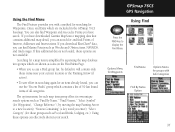
.... 4. Use the ROCKER key to display the Find Menu. 2. Press the MENU key to search for the marine Tide Prediction Stations provided in the marine basemap contained in your GPSmap 76CS. You can enter a key word for a known Tide Station tide station or can also view...of tide stations nearest to you to display the Tide Station Options Menu. GPSmap 76CS GPS Navigation Using Find Tide Station List Searching for a Marine Point The Find Marine Point feature allows you displays. When detailed marine map data has been downloaded from "Nearest Containing" or "Change Reference."...
.... 4. Use the ROCKER key to display the Find Menu. 2. Press the MENU key to search for the marine Tide Prediction Stations provided in the marine basemap contained in your GPSmap 76CS. You can enter a key word for a known Tide Station tide station or can also view...of tide stations nearest to you to display the Tide Station Options Menu. GPSmap 76CS GPS Navigation Using Find Tide Station List Searching for a Marine Point The Find Marine Point feature allows you displays. When detailed marine map data has been downloaded from "Nearest Containing" or "Change Reference."...

Owner's Manual
Page 51
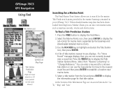
...list and press ENTER to display the sub-icon(s) for that item. At the bottom of marine services near the location you are on the previous page. 5. To find Marine Services 1. Use the ROCKER key to display the Find Menu. 2. Press the MENU key...highlight each information category and press ENTER to access the Marine Points Menu, then select the Marine Services icon. 2. If you get a "None Found" message, you have selected. 3. GPSmap 76CS GPS Navigation Using Find Wrecks/Obstructions List Marine Services List Detailed Information Detailed Information 41 When the ...
...list and press ENTER to display the sub-icon(s) for that item. At the bottom of marine services near the location you are on the previous page. 5. To find Marine Services 1. Use the ROCKER key to display the Find Menu. 2. Press the MENU key...highlight each information category and press ENTER to access the Marine Points Menu, then select the Marine Services icon. 2. If you get a "None Found" message, you have selected. 3. GPSmap 76CS GPS Navigation Using Find Wrecks/Obstructions List Marine Services List Detailed Information Detailed Information 41 When the ...

Owner's Manual
Page 73
... turn it off. Map Information Options Menu GPSmap 76CS GPS Navigation Map Setup The "Text Settings" Map Setup Page The "Map Information" Map Setup Page Map Setup - Use this page to control the display of marine chart items when using downloaded marine charts (i.e. You can select from Small, Medium... Text Settings The fourth page of the Map Setup is the Text Settings Page. Marine Settings The last page of the Map Setup feature is the Marine Settings Page. MapSource BlueChart® marine mapping data). Pressing the MENU key displays list of options for descriptions of downloaded ...
... turn it off. Map Information Options Menu GPSmap 76CS GPS Navigation Map Setup The "Text Settings" Map Setup Page The "Map Information" Map Setup Page Map Setup - Use this page to control the display of marine chart items when using downloaded marine charts (i.e. You can select from Small, Medium... Text Settings The fourth page of the Map Setup is the Text Settings Page. Marine Settings The last page of the Map Setup feature is the Marine Settings Page. MapSource BlueChart® marine mapping data). Pressing the MENU key displays list of options for descriptions of downloaded ...
Owner's Manual
Page 75
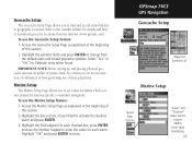
... are not in front of these properties. GPSmap 76CS GPS Navigation Geocache Setup Waypoint Symbols List Marine Setup Speed Filter Options "Deep" and "Shallow" water alarms require NMEA sonar input interfacing. 65 Highlight "OK" and press ENTER to change from the internet (www.garmin.com). Access the Marine Setup Page as explained at geographic locations...
... are not in front of these properties. GPSmap 76CS GPS Navigation Geocache Setup Waypoint Symbols List Marine Setup Speed Filter Options "Deep" and "Shallow" water alarms require NMEA sonar input interfacing. 65 Highlight "OK" and press ENTER to change from the internet (www.garmin.com). Access the Marine Setup Page as explained at geographic locations...

Owner's Manual
Page 90
... Refer to a PC for use with GPSmap 76CS, refer to the Garmin web site: http://garmin.com/products/gpsmap76cs/ Provides connection to Garmin web site: http://garmin.com/products/gpsmap76c/ for availability. 80 Accessories (Included with Garmin products. Allows installation on bicycle handlebar. ...Cable with USB cable drivers. Allows installation on a boat. Battery Pack - Marine Mount Kit - GA 27C Remote GPS Antenna with Garmin Products. Bicycle Handlebar Mount Kit - GPSmap 76CS Appendix Accessories USB Interface Cable and MapSource Trip and Waypoint Manager CD-ROM with...
... Refer to a PC for use with GPSmap 76CS, refer to the Garmin web site: http://garmin.com/products/gpsmap76cs/ Provides connection to Garmin web site: http://garmin.com/products/gpsmap76c/ for availability. 80 Accessories (Included with Garmin products. Allows installation on bicycle handlebar. ...Cable with USB cable drivers. Allows installation on a boat. Battery Pack - Marine Mount Kit - GA 27C Remote GPS Antenna with Garmin Products. Bicycle Handlebar Mount Kit - GPSmap 76CS Appendix Accessories USB Interface Cable and MapSource Trip and Waypoint Manager CD-ROM with...

Owner's Manual
Page 91
Installing the Carry Lanyard and Accessory Ports MCX External Antenna Connector (under weather cover) GPSmap 76CS Appendix Accessories Auto Navigation Kit USB Connector (under weather cover) Carry Lanyard Installation Back of GPSmap 76CS Power/Data Cable Connector "Serial Port" (under weather cover) Marine Mount Kit Bicycle Handlebar Mount Kit Rechargeable NiMH Battery Kit 81
Installing the Carry Lanyard and Accessory Ports MCX External Antenna Connector (under weather cover) GPSmap 76CS Appendix Accessories Auto Navigation Kit USB Connector (under weather cover) Carry Lanyard Installation Back of GPSmap 76CS Power/Data Cable Connector "Serial Port" (under weather cover) Marine Mount Kit Bicycle Handlebar Mount Kit Rechargeable NiMH Battery Kit 81

Owner's Manual
Page 105
...In Power(+) Ground(-) Data Out Unit Power/Data Port View Optional Power/Data Serial Port Cable with the GPSmap 76CS. The Garmin GBR 21 is supported by the GPSmap 76CS and enables the unit to drive up to three NMEA devices. The USB Interface Cable provided with the ... GPSmap 76CS to a PC-compatible computer's USB port. The input/output lines on page 58 of external devices, including PC's, differential beacon receivers, marine autopilots and /or a second GPS receiver. NMEA 0183 Version 3.01 Approved Sentences: GPGGA, GPGLL, GPGSA, GPGSV, GPRMB, GPRMC, GPRTE, GPVTG, GPWPL, GPBOD Garmin ...
...In Power(+) Ground(-) Data Out Unit Power/Data Port View Optional Power/Data Serial Port Cable with the GPSmap 76CS. The Garmin GBR 21 is supported by the GPSmap 76CS and enables the unit to drive up to three NMEA devices. The USB Interface Cable provided with the ... GPSmap 76CS to a PC-compatible computer's USB port. The input/output lines on page 58 of external devices, including PC's, differential beacon receivers, marine autopilots and /or a second GPS receiver. NMEA 0183 Version 3.01 Approved Sentences: GPGGA, GPGLL, GPGSA, GPGSV, GPRMB, GPRMC, GPRTE, GPVTG, GPWPL, GPBOD Garmin ...

Owner's Manual
Page 107
...66, 92 Map Display 8 Map Features 9 Map Page 8 Map Page Options 10 Map Page Panning 9 Map Scale 9 Map Setup 61 MapSource Map Data 8, 90 Marine Setup 63 Mark a Waypoint 27 Mark Waypoint Page 27 Measuring Distance 13 Microphone Sensitivity 8 MOB Feature 28 Moving a Route Waypoint 30 N Nearest (Waypoints, Cities, ...-55 Creating 51 Copying 55 Deleting 55 Editing 55 Profile 55 Navigating 55 Reversing 53 Vertical Profile 55 Routing Setup 64 GPSmap 76CS Appendix Index S Satellite Page 4 Saving the Tracklog 47 Selecting a Page 2 Setup Menu 57 Show Data Fields 10 Show Map Only 10 Sight 'N Go...
...66, 92 Map Display 8 Map Features 9 Map Page 8 Map Page Options 10 Map Page Panning 9 Map Scale 9 Map Setup 61 MapSource Map Data 8, 90 Marine Setup 63 Mark a Waypoint 27 Mark Waypoint Page 27 Measuring Distance 13 Microphone Sensitivity 8 MOB Feature 28 Moving a Route Waypoint 30 N Nearest (Waypoints, Cities, ...-55 Creating 51 Copying 55 Deleting 55 Editing 55 Profile 55 Navigating 55 Reversing 53 Vertical Profile 55 Routing Setup 64 GPSmap 76CS Appendix Index S Satellite Page 4 Saving the Tracklog 47 Selecting a Page 2 Setup Menu 57 Show Data Fields 10 Show Map Only 10 Sight 'N Go...


