
Owner's Manual
Page 3
... Find Menu, navigating a route, and using the pages. The Main Pages chapter provides detailed explanations about each page in the GPSMAP 76 and step-by -step directions to assist you in these operations. Read the Safety Information to learn how to configure your new GPSMAP 76. GPSMAP 76 Owner's Manual i This manual is provided at the end of Garmin GPS and full-featured mapping to create an unsurpassed portable GPS receiver...
... Find Menu, navigating a route, and using the pages. The Main Pages chapter provides detailed explanations about each page in the GPSMAP 76 and step-by -step directions to assist you in these operations. Read the Safety Information to learn how to configure your new GPSMAP 76. GPSMAP 76 Owner's Manual i This manual is provided at the end of Garmin GPS and full-featured mapping to create an unsurpassed portable GPS receiver...

Owner's Manual
Page 4
... Operation 4 Turning on the GPSMAP 76 4 Adjusting Backlight and Contrast 5 Selecting and Entering Data 5 Simulator Mode 5 Initializing the GPS Receiver 7 Initialization Options 8 Creating a Waypoint 9 New, Mark, and Waypoint Page Options............11 Editing Waypoints 11 Creating a New Route 15 Editing a Route 17 Starting to Navigate 20 Main Pages 22 GPS Information Page 23 Current GPS Receiver Status 23 GPS Information Page Options Menu 24 ii INTRODUCTION > TABLE OF CONTENTS Map Page 25 Using Additional Map Data 25 Changing the Zoom Range 25 Map Page Options 26 Setup Map...
... Operation 4 Turning on the GPSMAP 76 4 Adjusting Backlight and Contrast 5 Selecting and Entering Data 5 Simulator Mode 5 Initializing the GPS Receiver 7 Initialization Options 8 Creating a Waypoint 9 New, Mark, and Waypoint Page Options............11 Editing Waypoints 11 Creating a New Route 15 Editing a Route 17 Starting to Navigate 20 Main Pages 22 GPS Information Page 23 Current GPS Receiver Status 23 GPS Information Page Options Menu 24 ii INTRODUCTION > TABLE OF CONTENTS Map Page 25 Using Additional Map Data 25 Changing the Zoom Range 25 Map Page Options 26 Setup Map...
Owner's Manual
Page 6
... and then wipe dry. Clean the unit using this guide, contact Garmin Product Support in 1 meter of a car) as in the unit's memory without the need for 30 minutes. iv GPSMAP 76 Owner's Manual INTRODUCTION > CARE INFORMATION Care Information Cleaning the Unit The GPSMAP 76 is always a good practice to back up important user data by manually recording it or downloading it to a PC (transferring it to IEC Standard 60529 IPX7.
... and then wipe dry. Clean the unit using this guide, contact Garmin Product Support in 1 meter of a car) as in the unit's memory without the need for 30 minutes. iv GPSMAP 76 Owner's Manual INTRODUCTION > CARE INFORMATION Care Information Cleaning the Unit The GPSMAP 76 is always a good practice to back up important user data by manually recording it or downloading it to a PC (transferring it to IEC Standard 60529 IPX7.

Owner's Manual
Page 14
...-is turned off saving battery power. Start Simulator-is incorrect, select Stored w/o Batteries to search for satellites. This process may be severly degraded. 8 GPSMAP 76 Owner's Manual Then the unit continues to help the unit acquire satellites. If the date is used for satellites. When initializing the receiver or trying to receive satellite signals, orient the GPSMAP 76 so the top of the unit pointed toward the sky. Select the appropriate option to acquire satellites normally. Use Map...
...-is turned off saving battery power. Start Simulator-is incorrect, select Stored w/o Batteries to search for satellites. This process may be severly degraded. 8 GPSMAP 76 Owner's Manual Then the unit continues to help the unit acquire satellites. If the date is used for satellites. When initializing the receiver or trying to receive satellite signals, orient the GPSMAP 76 so the top of the unit pointed toward the sky. Select the appropriate option to acquire satellites normally. Use Map...
Owner's Manual
Page 23
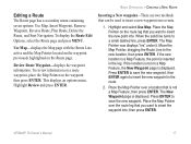
... the solid line turns to the new location, then press ENTER. To review information on a route waypoint, place the Map Pointer on a Map Feature, the New Waypoint page is not a Map Feature, then press ENTER. Place the Map Pointer over a location that you want to save the new waypoint. Editing a Route The Route page has a secondary menu containing seven options: Use Map, Insert Waypoint, Remove Waypoint, Reverse Route, Plan Route, Delete the Route, and Start Navigation. Place the Map Pointer over the route leg that is displayed.
... the solid line turns to the new location, then press ENTER. To review information on a route waypoint, place the Map Pointer on a Map Feature, the New Waypoint page is not a Map Feature, then press ENTER. Place the Map Pointer over a location that you want to save the new waypoint. Editing a Route The Route page has a secondary menu containing seven options: Use Map, Insert Waypoint, Remove Waypoint, Reverse Route, Plan Route, Delete the Route, and Start Navigation. Place the Map Pointer over the route leg that is displayed.
Owner's Manual
Page 30
... four satellites. Lost Satellite Reception-indicates that the GPS receiver has lost satellite reception. New Elevation-is using DGPS or WAAS differential data on the Map page to indicate your current track toward the top of the display or your approximate location and the unit continues to acquire satellites normally using the Simulator, the GPSMAP 76 cannot be used if you to begin navigation. This method does not require the unit to simulate. 24 GPSMAP 76 Owner's Manual This...
... four satellites. Lost Satellite Reception-indicates that the GPS receiver has lost satellite reception. New Elevation-is using DGPS or WAAS differential data on the Map page to indicate your current track toward the top of the display or your approximate location and the unit continues to acquire satellites normally using the Simulator, the GPSMAP 76 cannot be used if you to begin navigation. This method does not require the unit to simulate. 24 GPSMAP 76 Owner's Manual This...

Owner's Manual
Page 37
... to the active waypoint. Track Log-is left behind as shopping centers and university campuses Metro-Metropolitan Areas GPSMAP 76 Owner's Manual 31 Saved Tracks-are Track Logs that is the bread crumb trail that are saved in the unit's memory. MAIN PAGES > MAP PAGE Area Tab The Area tab contains the Text and Zoom settings for Track Log, Saved Tracks, Course Lines, and the Bearing Line. River/Lake...
... to the active waypoint. Track Log-is left behind as shopping centers and university campuses Metro-Metropolitan Areas GPSMAP 76 Owner's Manual 31 Saved Tracks-are Track Logs that is the bread crumb trail that are saved in the unit's memory. MAIN PAGES > MAP PAGE Area Tab The Area tab contains the Text and Zoom settings for Track Log, Saved Tracks, Course Lines, and the Bearing Line. River/Lake...

Owner's Manual
Page 39
... the current location. GPSMAP 76 Owner's Manual 33 Accuracy Circle-is not displayed. The Heading line appears as a thin black line. Other Tab The Other tab contains the Text and Zoom settings for Railroad and Text setting for the Accuracy Circle, Heading Line, and Lock to Roads is projected on the Map page. Heading Line-If the Heading line is On, a line showing your current heading is On, the unit attempts to match your current location...
... the current location. GPSMAP 76 Owner's Manual 33 Accuracy Circle-is not displayed. The Heading line appears as a thin black line. Other Tab The Other tab contains the Text and Zoom settings for Railroad and Text setting for the Accuracy Circle, Heading Line, and Lock to Roads is projected on the Map page. Heading Line-If the Heading line is On, a line showing your current heading is On, the unit attempts to match your current location...

Owner's Manual
Page 42
..., Line and Waypoint. The features are displayed. Active Leg-determines if the Active Leg is displayed. Saved Tracks-determines if Saved Tracks are arranged on the Graphic Highway. To select an option, highlight the desired selection and press ENTER. 36 Change Data Fields-allows you want displayed in the data fields. GPSMAP 76 Owner's Manual Setup Page Layout-allows you to select the text size and the number of data...
..., Line and Waypoint. The features are displayed. Active Leg-determines if the Active Leg is displayed. Saved Tracks-determines if Saved Tracks are arranged on the Graphic Highway. To select an option, highlight the desired selection and press ENTER. 36 Change Data Fields-allows you want displayed in the data fields. GPSMAP 76 Owner's Manual Setup Page Layout-allows you to select the text size and the number of data...

Owner's Manual
Page 46
Setup Track Log-displays the Track Log Setup menu: • Record-Select Wrap When Full to delete the oldest track point and create a new point added at the end when track memory is full. • Record Method-set to Auto, Time, or Distance. • Interval-is used and allows you to Save or Clear the current Track Log, and displays a list of any Saved Tracks. This ensures that you are going to want to...
Setup Track Log-displays the Track Log Setup menu: • Record-Select Wrap When Full to delete the oldest track point and create a new point added at the end when track memory is full. • Record Method-set to Auto, Time, or Distance. • Interval-is used and allows you to Save or Clear the current Track Log, and displays a list of any Saved Tracks. This ensures that you are going to want to...

Owner's Manual
Page 59
... choice. Current Date-shows the current date as determined by the user. This option is used. This field reflects any settings in a 12 or 24 hour format. GPSMAP 76 Owner's Manual 53 Time Tab The Time tab contains settings for the current location. MAIN MENU > SETUP MENU Time Format-displays time in the Daylight Savings Time field and is not accessible by the unit. The option Other creates the field UTC Offset. The Auto setting automatically determines...
... choice. Current Date-shows the current date as determined by the user. This option is used. This field reflects any settings in a 12 or 24 hour format. GPSMAP 76 Owner's Manual 53 Time Tab The Time tab contains settings for the current location. MAIN MENU > SETUP MENU Time Format-displays time in the Daylight Savings Time field and is not accessible by the unit. The option Other creates the field UTC Offset. The Auto setting automatically determines...

Owner's Manual
Page 60
...;nish. Speed Filter-allows the unit to average the speed and heading readings. Highlight the Seconds field then press ENTER to 54 adjust the number of seconds displayed, press ENTER to direction throughout the unit. The depth input has to come from a NMEA device providing the "DPT" sentence. Elevation-displays in related fields throughout the unit. GPSMAP 76 Owner's Manual The GPSMAP 76 cannot measure depth on its own. These settings are used in...
...;nish. Speed Filter-allows the unit to average the speed and heading readings. Highlight the Seconds field then press ENTER to 54 adjust the number of seconds displayed, press ENTER to direction throughout the unit. The depth input has to come from a NMEA device providing the "DPT" sentence. Elevation-displays in related fields throughout the unit. GPSMAP 76 Owner's Manual The GPSMAP 76 cannot measure depth on its own. These settings are used in...

Owner's Manual
Page 62
.... Automatic alerts you when the water is deeper than the user defined distance. The Off Course alarm can be turned On or Off. MAIN MENU > SETUP MENU Alarms Tab The Alarms tab contains settings for Anchor Drag, Approach and Arrival, Off Course, Shallow Water, and Deep Water. The Shallow Water alarm alerts you when the boat has drifted more than the depth set . 56 GPSMAP 76 Owner's Manual These settings determine if and when...
.... Automatic alerts you when the water is deeper than the user defined distance. The Off Course alarm can be turned On or Off. MAIN MENU > SETUP MENU Alarms Tab The Alarms tab contains settings for Anchor Drag, Approach and Arrival, Off Course, Shallow Water, and Deep Water. The Shallow Water alarm alerts you when the boat has drifted more than the depth set . 56 GPSMAP 76 Owner's Manual These settings determine if and when...
Owner's Manual
Page 63
... velocity information. GPSMAP 76 Owner's Manual 57 The Baud can be set to output simple text data that includes date, time, position, and velocity information. Interface Tab The Interface tab contains one field: Serial Data Format. The baud (speed of a nearby DGPS beacon. • NMEA-causes the unit to accept NMEA data from a device supplying RTCM data in the Baud field. The Baud can be set to communicate with Garmin software...
... velocity information. GPSMAP 76 Owner's Manual 57 The Baud can be set to output simple text data that includes date, time, position, and velocity information. Interface Tab The Interface tab contains one field: Serial Data Format. The baud (speed of a nearby DGPS beacon. • NMEA-causes the unit to accept NMEA data from a device supplying RTCM data in the Baud field. The Baud can be set to communicate with Garmin software...
Owner's Manual
Page 65
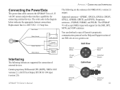
....garmin.com Data In White Unit View Ground Black Power Red Data In White Cable View Data Out Brown Power Red Ground Black Data Out Brown 59 GPSMAP 76 Owner's Manual APPENDIX > CONNECTING AND INTERFACING The following formats are the sentences for the DBT, DPT, MTW, and VHW sentences. The GPSMAP 76 will accept NMEA input with support for NMEA 0183, version 2.3 output: Approved sentences-GPRMC, GPGGA, GPGSA, GPGSV, GPGLL, GPBOD, GPRTE, and GPWPL; The color code...
....garmin.com Data In White Unit View Ground Black Power Red Data In White Cable View Data Out Brown Power Red Ground Black Data Out Brown 59 GPSMAP 76 Owner's Manual APPENDIX > CONNECTING AND INTERFACING The following formats are the sentences for the DBT, DPT, MTW, and VHW sentences. The GPSMAP 76 will accept NMEA input with support for NMEA 0183, version 2.3 output: Approved sentences-GPRMC, GPGGA, GPGSA, GPGSV, GPGLL, GPBOD, GPRTE, and GPWPL; The color code...
Owner's Manual
Page 72
... proximity waypoints can be saved. GPSMAP 76 Owner's Manual Deep Water-The water is deeper than 10 minutes of two proximity waypoints overlap. Off Course-You are nearing a turn in a route. APPENDIX > MESSAGES Messages Approaching Turn-is displayed when you are off course the distance set in the "Off Course" Alarm. The unit found . Near Proximity Point-You have the unit repaired. Can't Unlock Maps-No applicable unlock code for that already exists. Cannot display all found, use...
... proximity waypoints can be saved. GPSMAP 76 Owner's Manual Deep Water-The water is deeper than 10 minutes of two proximity waypoints overlap. Off Course-You are nearing a turn in a route. APPENDIX > MESSAGES Messages Approaching Turn-is displayed when you are off course the distance set in the "Off Course" Alarm. The unit found . Near Proximity Point-You have the unit repaired. Can't Unlock Maps-No applicable unlock code for that already exists. Cannot display all found, use...
Owner's Manual
Page 80
... practice operation using Simulator Mode prior to actual use . Tel. 44/0870.8501241 Fax 44/0870.8501251 The Garmin GPSMAP 76 has no user-serviceable parts. Garmin International, Inc. 1200 E 151st Street, Olathe, Kansas 66062 U.S.A. CAUTION: IT IS THE USER'S RESPONSIBILITY TO USE THIS PRODUCT PRUDENTLY. For safety, always resolve any Garmin warranty service station. Only of this Owner's Manual - APPENDIX > SAFETY INFORMATION To obtain warranty service, contact your unit, please...
... practice operation using Simulator Mode prior to actual use . Tel. 44/0870.8501241 Fax 44/0870.8501251 The Garmin GPSMAP 76 has no user-serviceable parts. Garmin International, Inc. 1200 E 151st Street, Olathe, Kansas 66062 U.S.A. CAUTION: IT IS THE USER'S RESPONSIBILITY TO USE THIS PRODUCT PRUDENTLY. For safety, always resolve any Garmin warranty service station. Only of this Owner's Manual - APPENDIX > SAFETY INFORMATION To obtain warranty service, contact your unit, please...
Owner's Manual
Page 81
.... GPSMAP 76 Owner's Manual 75 The system is a precision electronic NAVigation AID (NAVAID), any questions or would like additional information, please refer to our web site at http://www.garmin.com/prop65 APPENDIX > SAFETY INFORMATION Because the Garmin GPSMAP 76 can be used for its components contain chemicals known to the State of an accident. Please read and observe the following instructions. a combination of all data sources...
.... GPSMAP 76 Owner's Manual 75 The system is a precision electronic NAVigation AID (NAVAID), any questions or would like additional information, please refer to our web site at http://www.garmin.com/prop65 APPENDIX > SAFETY INFORMATION Because the Garmin GPSMAP 76 can be used for its components contain chemicals known to the State of an accident. Please read and observe the following instructions. a combination of all data sources...

Owner's Manual
Page 82
... iv Clearing the Track Log 40 Colors (Land/Water Mode) 28 Compass Ring 34 Configuring the Map 26 Contour Lines 32 Contrast Setting 5 Correction Signals 61 D Data Entry 5 Data Transfer 57 Date/Time 53, 60 Datum, Map 55, 62 Daylight Savings Time 53 Deep Water Alarm 56 Depth 54 Detail 28 DGPS 61 DGPS Interface Settings 57 DGPS Status 23, 24 Differential GPS 61 Distance 41 E Editing Waypoints. See Route Waypoints Addresses 45 Alarms 56 Anchor Drag Alarm...
... iv Clearing the Track Log 40 Colors (Land/Water Mode) 28 Compass Ring 34 Configuring the Map 26 Contour Lines 32 Contrast Setting 5 Correction Signals 61 D Data Entry 5 Data Transfer 57 Date/Time 53, 60 Datum, Map 55, 62 Daylight Savings Time 53 Deep Water Alarm 56 Depth 54 Detail 28 DGPS 61 DGPS Interface Settings 57 DGPS Status 23, 24 Differential GPS 61 Distance 41 E Editing Waypoints. See Route Waypoints Addresses 45 Alarms 56 Anchor Drag Alarm...

Owner's Manual
Page 84
... Time Format 53 Time Offsets 53 Time Zone 53 TracBack 41 Track Log 20, 31 Area 41 Clear 40 Delete 40, 41 Displaying 41 Recording 40 Save 31, 36, 40 Setup 36, 40 Showing on Map 41 78 Track Up 24 Trip Computer 39 Trip Odometer 39 Trip Timers 39 Turn On and Off 4 U Unit Settings 54 User Datum 55 W WAAS 52, 61 Warranty 73 Waterproof iv Water Mode 28 Waypoint...
... Time Format 53 Time Offsets 53 Time Zone 53 TracBack 41 Track Log 20, 31 Area 41 Clear 40 Delete 40, 41 Displaying 41 Recording 40 Save 31, 36, 40 Setup 36, 40 Showing on Map 41 78 Track Up 24 Trip Computer 39 Trip Odometer 39 Trip Timers 39 Turn On and Off 4 U Unit Settings 54 User Datum 55 W WAAS 52, 61 Warranty 73 Waterproof iv Water Mode 28 Waypoint...


