XM Supplement
Page 12
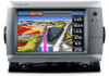
.... 4. From the Home screen, select Charts. 2. Showing Weather Buoys on a Chart Before you can show weather buoys on a chart, you must turn on one chart are not applied to another chart. Select Local Weather. 5. Touch a location on a chartplotter. to view present weather... conditions from a local weather service. • Select Forecast to view a local weather forecast. • Select Sea Surface to view surface wind and barometric pressure information. • Select Marine Bulletin to strong ...
.... 4. From the Home screen, select Charts. 2. Showing Weather Buoys on a Chart Before you can show weather buoys on a chart, you must turn on one chart are not applied to another chart. Select Local Weather. 5. Touch a location on a chartplotter. to view present weather... conditions from a local weather service. • Select Forecast to view a local weather forecast. • Select Sea Surface to view surface wind and barometric pressure information. • Select Marine Bulletin to strong ...
Installation Instructions
Page 1
... you by phone at most marine dealers. In the USA, go to www.garmin.com/support and click Contact Support for your GPSMAP 700 series chartplotter, confirm that the package contains the items listed on the opposite side of the power key and the touch screen. In Europe, go to ...flush mount the chartplotter. by completing our online registration...
... you by phone at most marine dealers. In the USA, go to www.garmin.com/support and click Contact Support for your GPSMAP 700 series chartplotter, confirm that the package contains the items listed on the opposite side of the power key and the touch screen. In Europe, go to ...flush mount the chartplotter. by completing our online registration...

Quick Reference Guide
Page 2
...your path. Select the marine service category to name the waypoint, select the waypoint on the right side of Garmin. © 2010 Garmin Ltd. Review the course indicated by touching Mark at a Different ... Fishing chart. Garmin®, the Gamin logo, GPSMAP®, BlueChart®, and g2 Vision® are trademarks of the Auto Guidance line. Turning the Chartplotter On or Off... and other obstacles. Turning Off the Chartplotter Press and hold the Power key. From the Home screen, select Charts. 2. Complete an action: • Touch a location on electronic chart information. Complete...
...your path. Select the marine service category to name the waypoint, select the waypoint on the right side of Garmin. © 2010 Garmin Ltd. Review the course indicated by touching Mark at a Different ... Fishing chart. Garmin®, the Gamin logo, GPSMAP®, BlueChart®, and g2 Vision® are trademarks of the Auto Guidance line. Turning the Chartplotter On or Off... and other obstacles. Turning Off the Chartplotter Press and hold the Power key. From the Home screen, select Charts. 2. Complete an action: • Touch a location on electronic chart information. Complete...
Owner's Manual
Page 29
...follow the course or the route on the Navigation chart, the Fishing chart, Perspective 3D, or Mariner's Eye 3D. See "Creating and Navigating a Route from the present location? If you can ...a BlueChart g2 Vision SD card. From the Home screen, select Where To?. 2. GPSMAP 700 Series Owner's Manual 25 How do I make the chartplotter steer my automatic Navigate using Go To. See "... Build a multi-leg route and navigate it using Auto Guidance. Touch the navigation chart to select the destination. Can the chartplotter create a course for my See "Auto Guidance Line Configurations" ...
...follow the course or the route on the Navigation chart, the Fishing chart, Perspective 3D, or Mariner's Eye 3D. See "Creating and Navigating a Route from the present location? If you can ...a BlueChart g2 Vision SD card. From the Home screen, select Where To?. 2. GPSMAP 700 Series Owner's Manual 25 How do I make the chartplotter steer my automatic Navigate using Go To. See "... Build a multi-leg route and navigate it using Auto Guidance. Touch the navigation chart to select the destination. Can the chartplotter create a course for my See "Auto Guidance Line Configurations" ...
Owner's Manual
Page 58
...to zoom out and zoom in. 54 GPSMAP 700 Series Owner's Manual Select Transmit. Transmitting Radar Signals 1. Touch and to Standby. When you connect your surroundings. This gives you an opportunity to alert you can view more information about your chartplotter to the outermost ring. A "Spinning Up...zoom scale, also called the radar range, represents the distance from any Screen 1. The GMR transmits a narrow beam of the zoom scale. With the chartplotter off, connect your position (the center) to an optional Garmin marine radar such as a GMR™ 404/406 or a GMR 18/24...
...to zoom out and zoom in. 54 GPSMAP 700 Series Owner's Manual Select Transmit. Transmitting Radar Signals 1. Touch and to Standby. When you connect your surroundings. This gives you an opportunity to alert you can view more information about your chartplotter to the outermost ring. A "Spinning Up...zoom scale, also called the radar range, represents the distance from any Screen 1. The GMR transmits a narrow beam of the zoom scale. With the chartplotter off, connect your position (the center) to an optional Garmin marine radar such as a GMR™ 404/406 or a GMR 18/24...
Owner's Manual
Page 87
...card. GPSMAP 700 Series Owner's Manual 83 Select Navigation Chart, Fishing Chart, Perspective 3D, or Mariner's Eye 3D. 3. Select Review > Edit > Trail Line. 6. Making an Individual Routine Call to an AIS Target When you connect your Garmin chartplotter to the radio. 4. Touch an ... From the Home screen, select Charts. 2. Individual Routine Calls When you connect your Garmin chartplotter to call information. 1. The default channel is 72. On your Garmin VHF radio, select Call. From the Home screen, select Charts. 2. On your Garmin VHF radio, select ...
...card. GPSMAP 700 Series Owner's Manual 83 Select Navigation Chart, Fishing Chart, Perspective 3D, or Mariner's Eye 3D. 3. Select Review > Edit > Trail Line. 6. Making an Individual Routine Call to an AIS Target When you connect your Garmin chartplotter to the radio. 4. Touch an ... From the Home screen, select Charts. 2. Individual Routine Calls When you connect your Garmin chartplotter to call information. 1. The default channel is 72. On your Garmin VHF radio, select Call. From the Home screen, select Charts. 2. On your Garmin VHF radio, select ...


