Garmin GPSMAP 5015 Support Question
Garmin GPSMAP 5015 Support Question
Find answers below for this question about Garmin GPSMAP 5015.Need a Garmin GPSMAP 5015 manual? We have 8 online manuals for this item!
Question posted by dub03222 on May 31st, 2021
Touch Screen
Screen not working. Checked power connection is OK
Current Answers
Answer #1: Posted by SonuKumar on May 31st, 2021 8:57 PM
SonuKumar

Member since:
May 9th, 2021 Points: 16,604,000

Member since:
May 9th, 2021 Points: 16,604,000
https://www.youtube.com/results?search_query=garmin+gpsmap+5015+screen+not+working
https://www.youtube.com/watch?v=QoDzv2SIR0c
Please respond to my effort to provide you with the best possible solution by using the "Acceptable Solution" and/or the "Helpful" buttons when the answer has proven to be helpful.
Regards,
Sonu
Your search handyman for all e-support needs!!
Answer #2: Posted by Odin on May 31st, 2021 10:02 AM
Odin

Member since:
April 10th, 2010 Points: 41,236,700
Member since:
April 10th, 2010 Points: 41,236,700
Try the following:
1. While the chart plotter is turned off, press the power key. The Warning screen appears.
2. Touch anywhere on the black portion of the screen for approximately 15 seconds until the calibration screen appears.
3. Follow the instructions on the screen until "Calibration is complete" appears.
4. Touch OK.
If the issue persists or if you require further advice, you may want to consult the company: use the contact information at https://www.contacthelp.com/garmin/customer-service.
Hope this is useful. Please don't forget to click the Accept This Answer button if you do accept it. My aim is to provide reliable helpful answers, not just a lot of them. See https://www.helpowl.com/profile/Odin.
Related Garmin GPSMAP 5015 Manual Pages
Owner's Manual - Page 3
...:
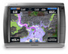
• GPSMAP® 4008 • GPSMAP® 4010 • GPSMAP® 4012 • GPSMAP® 5008 • GPSMAP® 5012 • GPSMAP® 5015
Introduction
Tips and Shortcuts
• Press or touch HOME from any screen to return to the Home screen.
• Press or touch MENU from any main screen to access additional settings.
• Press and release the Power key to...
Owner's Manual - Page 22
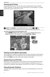
...and harbors.
To access aerial photos from the Navigation chart: Use the ROCKER (GPSMAP 4000 series) or touch the screen (GPSMAP 5000 series) to highlight a camera icon with a marina or harbor prior to...current at a
glance.
Using Charts
Note: Use the RANGE (+/-) keys (GPSMAP 4000 series) or touch the and keys (GPSMAP 5000 series) to zoom in your surroundings or to display a current graph...
Owner's Manual - Page 23

...series)
Navigation Chart, Radar, and Sonar Combination (GPSMAP 4000 series)
Select to four screens (GPSMAP 5000 series). When viewing three combination screens, one of options available on the Combinations screen depends on the optional network devices you have connected to select a single-screen combination page that represents the screen you are numbered with a corresponding button in...
Owner's Manual - Page 24
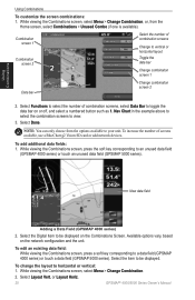
... a BlueChart g2 Vision SD card or add network devices. To change the layout to an unused data field
(GPSMAP 4000 series) or touch an unused data field (GPSMAP 5000 series). While viewing the Combinations screen, press the soft key corresponding to horizontal or vertical: 1. Nav Chart in the example above to select the combination...
Owner's Manual - Page 26

... select Menu, and then select Stop Navigation.
Use the ROCKER (GPSMAP 4000 series) or touch the onscreen keyboard (GPSMAP 5000 series) to view the 50 nearest destinations that contain your ...g2 Vision card).
22
GPSMAP® 4000/5000 Series Owner's Manual GPSMAP 5000 series
3. Select Navigate To. 5. From the Home screen, select Where To? > Search by name: 1. GPSMAP 4000 series
Search -...
Owner's Manual - Page 36
... named Demo.)
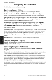
Auto Power Up (GPSMAP 4010 and GPSMAP 5015 only)-turn in a route that you transition to brighten or darken the backlight. Select Color Mode to configure unit settings. Configuring the Chartplotter
Configuring the Chartplotter
Use the Configure screen to switch between Water (from a water-speed sensor) and GPS (from the calculated GPS speed). Select Setup...
Owner's Manual - Page 41
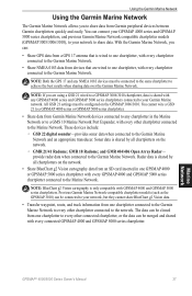
... or to share data. Using the Garmin Marine Network
Using the Garmin Marine Network
The Garmin Marine Network allows you to the Garmin Marine Network.
NOTE: Both the GPS 17 and any chartplotter in one chartplotter, with any GPSMAP 4000 series and GPSMAP 5000 series chartplotters connected to the Marine Network. Sonar data is shared by all chartplotters on...
Owner's Manual - Page 42
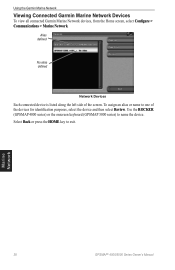
Using the Garmin Marine Network
Viewing Connected Garmin Marine Network Devices
To view all connected Garmin Marine Network devices, from the Home screen, select Configure > Communications > Marine Network. Alias defined
No alias defined
Network Devices
Each connected device is listed along the left side of the devices for identification purposes, select the device and then select Review.
To...
Owner's Manual - Page 45

Select Corner 1 or Corner 2 to
begin targeting.
Corner 1
Corner 2
Circular
Radar Targeting
Use the ROCKER (GPSMAP 4000 series) or touch the target location (GPSMAP 5000 series) to change the reference point. As you move the target over objects on the screen at the targeted object or location. Create Waypoint-marks a waypoint at which you want...
Owner's Manual - Page 47

.../EBL target location: • (GPSMAP 4000 series) On the Radar screen, use the ROCKER to move the pointer (GPSMAP 4000 series) or touch the target location
(GPSMAP 5000 series). 3.
NOTE: To ... EBL are shown, from the Radar screen, select Menu > Adjust VRM/EBL >
Hide VRM/EBL. You can be connected to an external AIS or DSC device.
From the Radar screen, select Menu > Adjust VRM/EBL...
Technical Reference for Garmin NMEA 2000 Products - Page 7
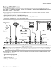
... by creating a diagram of the network. others may require a separate power connection. Be sure to function correctly. The NMEA 2000 backbone must be connected to power, and terminators must follow certain rules to each device (Load Equivalency Number)
Fuel sensor
Marine instrument
Chartplotter
Intelligent transducer
Ignition or in-line switch
Fuse
Female terminator
+
-
Some...
Installation Instructions - Page 1
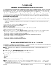
... chosen. Because of the controls or touch screen. Choose mounting hardware that provides a clear, glare-free view of the display and easy operation of the larger size, you can use the GPSMAP 4000/5000 chartplotter, this manual covers other installation options: • Connecting the chartplotter to other Garmin Marine Network compatible devices, such as a sounder...
Installation Instructions - Page 9

....
Be sure to the diagram for the boat. Route the cable to a Garmin Marine Network. Wiring the Power Cable
The GPSMAP 4000/5000 series chartplotter must be connected to the power supply for trimming instructions. The GPS signal is seated. Optional Garmin Marine Network components use specialized Garmin Network cables. Garmin rubber grommets are using more than...
Installation Instructions - Page 10
... on the NMEA 2000 guidelines.
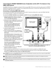
Caution: If you want to connect the chartplotter. The chartplotter must also be connected to power. Note: One GPS antenna will not function. Connecting the GPSMAP 4000/5000 Series Chartplotter and the GPS 17x Antenna to Your NMEA 2000 Network
The GPSMAP 4000/5000 series chartplotter is packaged with the necessary NMEA 2000...
Installation Instructions - Page 12

... ports, use a Garmin Marine Network port extender (GMS 10), or another GPSMAP 4000/5000. Data from connected network compatible Garmin devices such as a Garmin sonar unit (GSD 22), a Garmin radar (GMR 18 or GMR 404/406), or an XM Weather receiver (GDL30/30A). The following diagrams show only the network connections, not power connections.
• Currently...
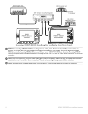
Installation Instructions - Page 13

... 22 sounder unit
xxxxxxxxxxxxxxxxxxxxxxx
To transducer
Garmin GPSMAP 4000/5000 series
chartplotter
Garmin GPSMAP 4000/5000 series
chartplotter
Extended Marine Network With Two Chartplotters
Note: Every device connected to the Garmin Marine Network must be connected to the appropriate installation instructions. These diagrams show the power connections. however, they do not show the network...
Installation Instructions - Page 14
... to an Existing Garmin Marine Network
Note: When connecting a GPSMAP 4000/5000 series chartplotter to an existing Garmin Marine Network, the GMS 10 can be connected to the power supply for the boat. Wire the GPS antenna and additional NMEA devices to the appropriate installation instructions. however, it does not show the power connections. The existing GPSMAP 3000 series chartplotter...
Installation Instructions - Page 17

... / A(+)
rX / A(+) >
>
TX / B(-)
rX / B(-) >
Wiring to a NMEA 0183-compliant Device With a Single Wire TX Connection
Garmin GPSMAP 4000/5000 series
unit
Power cable NMEA 0183 Cable
Wire see table for
Fuse
wire colors
7.5 A - 42 V Red (power)
+
- Battery
10-35 Vdc
Wire Red (power)
Black (pwr gnd)
Black (pwr gnd)
Black (data GND)
Black (data GND)
RX...
Installation Instructions - Page 18

... visual and audible alerts, install a switch.
Wiring to an Optional Alarm
The GPSMAP 4000/5000 series chartplotter can be connected to a PC with a lamp, a horn, or both .
Garmin GPSMAP 4000/5000 series
chartplotter
Power cable NMEA 0183 Cable
Wire see table for the GPSMAP 4000/5000 chartplotter to a DB-9 Serial PC Connector
DB-9 pin numbers...
Quick Reference Guide - Page 1

... to create a specific route to Destination GPSMAP® 5000 Series
quick reference guide
List of the 50 nearest locations and the distance and bearing to change (Name, Symbol, Depth, Water Temp, or
Comment). To delete a waypoint: 1. From the Home screen, touch Where To? > Offshore Services. 2. Touch the marine service category to which you want to...
Similar Questions

How Do I Go Into Simulation Mode On A Garmin Marine Gps Modle741xs
how do I use simulation mode on a garmin 741xs marine ver
how do I use simulation mode on a garmin 741xs marine ver
(Posted by Curthupp 6 years ago)

In My Garmen Gpsmap 430x Is Not Working No Power What Can I Do
in my garmen GPSmap 430x is not working no power what can i do
in my garmen GPSmap 430x is not working no power what can i do
(Posted by kamalessam 8 years ago)


Gpsmap 431s Was Working And Then Screen Freeze And Does Not Start Anymore
GPSMAP 431S was working and then screen freeze and does not start anymore. It shows no map only some...
GPSMAP 431S was working and then screen freeze and does not start anymore. It shows no map only some...
(Posted by leomarchevsky 10 years ago)

Oyster 56 With Garmin 5015 Installed. Track And Heading Query.
The heading line is all over the place (its a sailing boat)! A track up facility would be perfect a...
The heading line is all over the place (its a sailing boat)! A track up facility would be perfect a...
(Posted by terry6824 11 years ago)