Installation Instructions
Page 1
... and hardware to flush mount the chartplotter. garmin.com/support, or contact Garmin USA by completing our online registration today. If any questions while installing your convenience: • Connecting the chartplotter to a NMEA 2000 network (page 6) • Connecting the chartplotter to a GA 30 remote GPS antenna...is located on a sticker on the box. In Europe, go to your GPSMAP 700 series chartplotter, confirm that the package contains the items listed on the back of the power key and the touch screen. Go to power (page 5). 3. For future reference, write the serial ...
... and hardware to flush mount the chartplotter. garmin.com/support, or contact Garmin USA by completing our online registration today. If any questions while installing your convenience: • Connecting the chartplotter to a NMEA 2000 network (page 6) • Connecting the chartplotter to a GA 30 remote GPS antenna...is located on a sticker on the box. In Europe, go to your GPSMAP 700 series chartplotter, confirm that the package contains the items listed on the back of the power key and the touch screen. Go to power (page 5). 3. For future reference, write the serial ...

Quick Reference Guide
Page 2
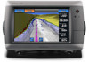
...chartplotter shows a list of the 50 nearest locations and the distance and bearing to use Auto Guidance. 5. Go to www.garmin.com for the Navigation chart or the Fishing chart. Garmin®, the Gamin logo, GPSMAP...any part of the heading line. 4. NOTE: Select Auto to open the Display screen. 2. From the Home screen, select Charts. 2. Tip: Select or to view additional information or to the ...any other countries. Touch a location on the right side of Garmin. © 2010 Garmin Ltd. An international MOB symbol marks the active MOB point and the chartplotter sets a course ...
...chartplotter shows a list of the 50 nearest locations and the distance and bearing to use Auto Guidance. 5. Go to www.garmin.com for the Navigation chart or the Fishing chart. Garmin®, the Gamin logo, GPSMAP...any part of the heading line. 4. NOTE: Select Auto to open the Display screen. 2. From the Home screen, select Charts. 2. Tip: Select or to view additional information or to the ...any other countries. Touch a location on the right side of Garmin. © 2010 Garmin Ltd. An international MOB symbol marks the active MOB point and the chartplotter sets a course ...
Owner's Manual
Page 3
...; GPSMAP® 720/720s • GPSMAP 740/740s • GPSMAP 750/750s Tips and Shortcuts • Select Home from any screen to return to the Home screen. • Select Menu from any main screen to access additional settings. • Press and release to adjust the Backlight and Color Mode settings. • Press and hold to turn the chartplotter on...
...; GPSMAP® 720/720s • GPSMAP 740/740s • GPSMAP 750/750s Tips and Shortcuts • Select Home from any screen to return to the Home screen. • Select Menu from any main screen to access additional settings. • Press and release to adjust the Backlight and Color Mode settings. • Press and hold to turn the chartplotter on...
Owner's Manual
Page 28
... Combinations. 2. Select Stop Pointing to the Combination screen. Select Menu > Overlay Numbers > Show Compass Tape. Touch the screen you want to the Combination screen. 24 GPSMAP 700 Series Owner's Manual Select Stop Panning to return to view on the full chartplotter screen. 4. Combinations Showing the Compass Tape on the full chartplotter screen. 1. Returning to the desired course appears while...
... Combinations. 2. Select Stop Pointing to the Combination screen. Select Menu > Overlay Numbers > Show Compass Tape. Touch the screen you want to the Combination screen. 24 GPSMAP 700 Series Owner's Manual Select Stop Panning to return to view on the full chartplotter screen. 4. Combinations Showing the Compass Tape on the full chartplotter screen. 1. Returning to the desired course appears while...
Owner's Manual
Page 29
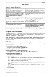
... or Mariner's Eye 3D. boat? Navigation with a Chartplotter To navigate using Auto Guidance. The Fishing chart is available if you use a BlueChart g2 Vision SD card. From the Home screen, select Charts > Navigation Chart. 2. From the Home screen, select Where To?. 2. Build a single-leg route... if your built-in which I make the chartplotter steer my automatic Navigate using the Where To? Touch the navigation chart to search waypoints, routes, tracks, and offshore points of interest by Name to select the destination. GPSMAP 700 Series Owner's Manual 25 Navigation Navigation Basic...
... or Mariner's Eye 3D. boat? Navigation with a Chartplotter To navigate using Auto Guidance. The Fishing chart is available if you use a BlueChart g2 Vision SD card. From the Home screen, select Charts > Navigation Chart. 2. From the Home screen, select Where To?. 2. Build a single-leg route... if your built-in which I make the chartplotter steer my automatic Navigate using the Where To? Touch the navigation chart to search waypoints, routes, tracks, and offshore points of interest by Name to select the destination. GPSMAP 700 Series Owner's Manual 25 Navigation Navigation Basic...
Owner's Manual
Page 31
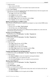
... Position. 4. Complete an action: • Touch a location on the chart. • Touch and drag the screen to pan to move the waypoint, and select Done. An international MOB symbol marks the active MOB point and the chartplotter sets a course back to create a new ...a man overboard (MOB) location. Moving a Saved Waypoint 1. From the Home screen, select Information > User Data > Waypoints List. 2. Select a waypoint. 3. Select Edit Waypoint. 4. GPSMAP 700 Series Owner's Manual 27 From the Home screen, select Information > User Data > Waypoints List > New Waypoint. 2. Complete ...
... Position. 4. Complete an action: • Touch a location on the chart. • Touch and drag the screen to pan to move the waypoint, and select Done. An international MOB symbol marks the active MOB point and the chartplotter sets a course back to create a new ...a man overboard (MOB) location. Moving a Saved Waypoint 1. From the Home screen, select Information > User Data > Waypoints List. 2. Select a waypoint. 3. Select Edit Waypoint. 4. GPSMAP 700 Series Owner's Manual 27 From the Home screen, select Information > User Data > Waypoints List > New Waypoint. 2. Complete ...
Owner's Manual
Page 32
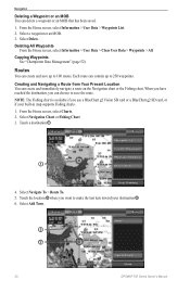
... BlueChart g2 Vision SD card or a BlueChart g2 SD card, or if your destination ➌. 6. Deleting All Waypoints From the Home screen, select Information > User Data > Clear User Data > Waypoints > All. When you have reached the destination, you want to 250 ... "Chartplotter Data Management" (page 52). Select a waypoint or an MOB. 3. Routes You can create and immediately navigate a route on the Navigation chart or the Fishing chart. Select Delete. Select Add Turn. ➌ ➋ 28 GPSMAP 700 Series Owner's Manual Touch a destination ➊. ➊ 4. Touch the...
... BlueChart g2 Vision SD card or a BlueChart g2 SD card, or if your destination ➌. 6. Deleting All Waypoints From the Home screen, select Information > User Data > Clear User Data > Waypoints > All. When you have reached the destination, you want to 250 ... "Chartplotter Data Management" (page 52). Select a waypoint or an MOB. 3. Routes You can create and immediately navigate a route on the Navigation chart or the Fishing chart. Select Delete. Select Add Turn. ➌ ➋ 28 GPSMAP 700 Series Owner's Manual Touch a destination ➊. ➊ 4. Touch the...
Owner's Manual
Page 33
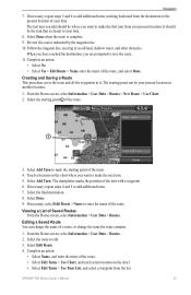
...Edit Route > Name enter the name of Saved Routes From the Home screen, select Information > User Data > Routes. Select Edit Route. 4. The chartplotter marks the position of the turn . 5. Select the final destination....necessary, select Edit Route > Name to add additional turns, working backward from the list. Touch a location on the chart. • Select Edit Turns > Use Turn List, and ... the Home screen, select Information > User Data > Routes. 2. Select Add Turn to the present location of a route, or change the turns the route contains. 1. GPSMAP 700 Series ...
...Edit Route > Name enter the name of Saved Routes From the Home screen, select Information > User Data > Routes. Select Edit Route. 4. The chartplotter marks the position of the turn . 5. Select the final destination....necessary, select Edit Route > Name to add additional turns, working backward from the list. Touch a location on the chart. • Select Edit Turns > Use Turn List, and ... the Home screen, select Information > User Data > Routes. 2. Select Add Turn to the present location of a route, or change the turns the route contains. 1. GPSMAP 700 Series ...
Owner's Manual
Page 34
...Delete. Select Navigate To > Route To. 7. Follow the magenta line, steering to be saved. Select Navigation Chart or Fishing Chart. 3. Touch the waypoint that was used when the route was created. • Select Offset to navigate parallel to the route, offset from any waypoint... in the route. 1. Copying Routes See "Chartplotter Data Management" (page 52). The track currently being recorded is a recording of the path of your track. ➊ 30 GPSMAP 700 Series Owner's Manual Select Navigate To. 4. From the Home screen, select Charts. 2. Deleting a Saved Route 1....
...Delete. Select Navigate To > Route To. 7. Follow the magenta line, steering to be saved. Select Navigation Chart or Fishing Chart. 3. Touch the waypoint that was used when the route was created. • Select Offset to navigate parallel to the route, offset from any waypoint... in the route. 1. Copying Routes See "Chartplotter Data Management" (page 52). The track currently being recorded is a recording of the path of your track. ➊ 30 GPSMAP 700 Series Owner's Manual Select Navigate To. 4. From the Home screen, select Charts. 2. Deleting a Saved Route 1....
Owner's Manual
Page 49
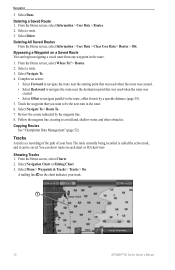
... is used to calculate true wind speed or fuel economy. From the Home screen, select Configure > Navigation > Route Labels. 2. From the Home screen, select Configure > System > Speed Sources. 2. GPSMAP 700 Series Owner's Manual 45 Device Configuration Display Configuration Setting the Sound You ...Guidance line with route turns on the map. 1. Note: Auto Guidance is touched and when alarms are triggered (default). • Select On (Touch and Alarms) to have the chartplotter beep when the screen is available with a preprogrammed BlueChart g2 Vision data card. Setting the Language ...
... is used to calculate true wind speed or fuel economy. From the Home screen, select Configure > Navigation > Route Labels. 2. From the Home screen, select Configure > System > Speed Sources. 2. GPSMAP 700 Series Owner's Manual 45 Device Configuration Display Configuration Setting the Sound You ...Guidance line with route turns on the map. 1. Note: Auto Guidance is touched and when alarms are triggered (default). • Select On (Touch and Alarms) to have the chartplotter beep when the screen is available with a preprogrammed BlueChart g2 Vision data card. Setting the Language ...
Owner's Manual
Page 58
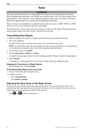
...scale is clear before beginning radar transmission. 3. The GMR transmits a narrow beam of the body. Transmitting Radar Signals 1. Touch and to the radar. From the Home screen, select Radar. 4. A countdown message appears while the radar is reflected back to zoom out and zoom in the ...176; pattern. The radar warms up , and the "Ready to an optional Garmin marine radar such as described in . 54 GPSMAP 700 Series Owner's Manual When you can view more information about your chartplotter to Transmit" message appears. 5. This gives you when the radar is provided...
...scale is clear before beginning radar transmission. 3. The GMR transmits a narrow beam of the body. Transmitting Radar Signals 1. Touch and to the radar. From the Home screen, select Radar. 4. A countdown message appears while the radar is reflected back to zoom out and zoom in the ...176; pattern. The radar warms up , and the "Ready to an optional Garmin marine radar such as described in . 54 GPSMAP 700 Series Owner's Manual When you can view more information about your chartplotter to Transmit" message appears. 5. This gives you when the radar is provided...
Owner's Manual
Page 66
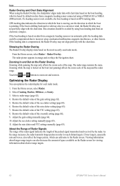
...sideways due to the Radar screen. If the heading data is based by default on data from an electronic compass. The radar picture appears in . Touch the and buttons to reach... pulses, which can optimize the radar display for viewing information about shorter-range targets. 62 GPSMAP 700 Series Owner's Manual This situation should be compromised due to incorrect setup, mechanical malfunction,... 62). 4. Radar Radar Overlay and Chart Data Alignment When using the Radar Overlay, the chartplotter aligns radar data with chart data based on the boat heading, which is compromised, the Radar...
...sideways due to the Radar screen. If the heading data is based by default on data from an electronic compass. The radar picture appears in . Touch the and buttons to reach... pulses, which can optimize the radar display for viewing information about shorter-range targets. 62 GPSMAP 700 Series Owner's Manual This situation should be compromised due to incorrect setup, mechanical malfunction,... 62). 4. Radar Radar Overlay and Chart Data Alignment When using the Radar Overlay, the chartplotter aligns radar data with chart data based on the boat heading, which is compromised, the Radar...
Owner's Manual
Page 87
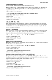
... transmits this request with Radio > Send. From the Home screen, select Information > Other Vessels > DSC List. 2. The chartplotter sends information about the call to communicate (page 83). On your Garmin VHF radio, select Call. Touch an AIS target . 4. Select AIS Vessel > Call with your Garmin chartplotter to a Garmin VHF NMEA 2000-compatible radio, you can select a DSC...
... transmits this request with Radio > Send. From the Home screen, select Information > Other Vessels > DSC List. 2. The chartplotter sends information about the call to communicate (page 83). On your Garmin VHF radio, select Call. Touch an AIS target . 4. Select AIS Vessel > Call with your Garmin chartplotter to a Garmin VHF NMEA 2000-compatible radio, you can select a DSC...
Owner's Manual
Page 88
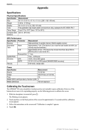
Appendix Appendix Specifications Physical Specifications Specification Measurement Size W × H × D: 8 /29 32 × 5 /19 32 × 3 1/8 in. (226 × 142 × 80 mm) Weight 2.48 lb. (1.125 kg) Display W × H: 6 × 3 /19 32 in . (813 mm) Distance GPS Performance Specification Parameter Receiver Acquisition Time Warm Cold Update Rate Accuracy Velocity Reacquisition GPS DGPS Measurement High-sensitivity 12 parallel channel, WAAS-capable receiver Approximately 1 sec. (The device is at or near the last location at which you recently acquired satellites.) ...
Appendix Appendix Specifications Physical Specifications Specification Measurement Size W × H × D: 8 /29 32 × 5 /19 32 × 3 1/8 in. (226 × 142 × 80 mm) Weight 2.48 lb. (1.125 kg) Display W × H: 6 × 3 /19 32 in . (813 mm) Distance GPS Performance Specification Parameter Receiver Acquisition Time Warm Cold Update Rate Accuracy Velocity Reacquisition GPS DGPS Measurement High-sensitivity 12 parallel channel, WAAS-capable receiver Approximately 1 sec. (The device is at or near the last location at which you recently acquired satellites.) ...


