
Important Safety and Product Information
Page 2
...if they suggest an illegal maneuver or would put you have on the windshield. Follow these guidelines are able to accept street maps and suggest routes that you in a safe and legal manner before attempting such operations. • When navigating, carefully compare ...8226; When installing the device in all circumstances. Keep your activity. Battery Warnings Your GPS device uses user-replaceable batteries. The Garmin device is not a replacement for attentiveness and proper preparation for driver attentiveness and good judgement. This notice is provided in death or...
...if they suggest an illegal maneuver or would put you have on the windshield. Follow these guidelines are able to accept street maps and suggest routes that you in a safe and legal manner before attempting such operations. • When navigating, carefully compare ...8226; When installing the device in all circumstances. Keep your activity. Battery Warnings Your GPS device uses user-replaceable batteries. The Garmin device is not a replacement for attentiveness and proper preparation for driver attentiveness and good judgement. This notice is provided in death or...

Important Safety and Product Information
Page 3
...does cause harmful interference to radio or television reception, which can radiate radio frequency energy and may contain perchlorate material. Map Data Information Garmin uses a combination of direct sunlight, such as in a location that obstruct the driver's vision. Unauthorized repairs or ...drive. Notice Windshield Mounting Legal Restrictions Before using suction mounts on your local waste disposal department to dispose of Conformity Hereby, Garmin, declares that interference will not occur in compliance with applicable local laws and regulations. • In addition, the GPS...
...does cause harmful interference to radio or television reception, which can radiate radio frequency energy and may contain perchlorate material. Map Data Information Garmin uses a combination of direct sunlight, such as in a location that obstruct the driver's vision. Unauthorized repairs or ...drive. Notice Windshield Mounting Legal Restrictions Before using suction mounts on your local waste disposal department to dispose of Conformity Hereby, Garmin, declares that interference will not occur in compliance with applicable local laws and regulations. • In addition, the GPS...

Important Safety and Product Information
Page 4
... Standard RSS-310. Write the tracking number clearly on the outside the United States depending on the country. Garmin will not replace missing components from any Garmin warranty service station. International Purchases: A separate warranty may cause undesired operation of map data in contravention of the laws of any purpose requiring precise measurement of...
... Standard RSS-310. Write the tracking number clearly on the outside the United States depending on the country. Garmin will not replace missing components from any Garmin warranty service station. International Purchases: A separate warranty may cause undesired operation of map data in contravention of the laws of any purpose requiring precise measurement of...
Owner's Manual
Page 3
...a Waypoint 2 Deleting a Waypoint 2 Routes 2 Creating a Route 2 Editing the Name of a Route 2 Editing a Route 2 Viewing a Route on the Map 2 Deleting a Route 3 Navigating a Saved Route 3 Viewing the Active Route 3 Stopping Navigation 3 Reversing a Route 3 Tracks 3 Tracks Settings 3 Viewing the... Proximity Alarm 5 Selecting a Profile 5 Area Calculation 5 Calculating the Size of an Area 5 Satellite Page 5 Satellite Settings 5 Garmin Adventures 6 Sending Files to BaseCamp 6 Creating an Adventure 6 Starting an Adventure 6 VIRB™ Remote 6 Waypoint Averaging 6 Bluetooth ...
...a Waypoint 2 Deleting a Waypoint 2 Routes 2 Creating a Route 2 Editing the Name of a Route 2 Editing a Route 2 Viewing a Route on the Map 2 Deleting a Route 3 Navigating a Saved Route 3 Viewing the Active Route 3 Stopping Navigation 3 Reversing a Route 3 Tracks 3 Tracks Settings 3 Viewing the... Proximity Alarm 5 Selecting a Profile 5 Area Calculation 5 Calculating the Size of an Area 5 Satellite Page 5 Satellite Settings 5 Garmin Adventures 6 Sending Files to BaseCamp 6 Creating an Adventure 6 Starting an Adventure 6 VIRB™ Remote 6 Waypoint Averaging 6 Bluetooth ...
Owner's Manual
Page 6
...route. Creating a Route 1 Select Route Planner > Create Route > Select First Point. 2 Select a category. 3 Select the first point in on the map. The additional point is currently open. Turning On the Device Hold . Editing a Route 1 Select Route Planner. 2 Select a route. 3 Select Edit ...Route. 4 Select a point. 5 Select an option: • To view the point on the map, select Review. • To change the order of waypoints or locations that is inserted before the point you must create a waypoint. 1 Select Waypoint...
...route. Creating a Route 1 Select Route Planner > Create Route > Select First Point. 2 Select a category. 3 Select the first point in on the map. The additional point is currently open. Turning On the Device Hold . Editing a Route 1 Select Route Planner. 2 Select a route. 3 Select Edit ...Route. 4 Select a point. 5 Select an option: • To view the point on the map, select Review. • To change the order of waypoints or locations that is inserted before the point you must create a waypoint. 1 Select Waypoint...
Owner's Manual
Page 7
...When you can use optional City Navigator® maps to a destination, your path. Map Settings Select Setup > Map. Orientation: Adjusts how the map is found on the map. 3 Select View Map. Track Log: Turns track recording on the map. Recording Interval: Sets a track log recording ...computer, and elevation plot pages. Select PAGE to view additional details. North Up shows north at (www.garmin.com). 2 Click the Maps tab. 3 Follow the on the map, select View Map. • To show an automotive perspective with your tracks. Reversing a Route 1 Select Route Planner. ...
...When you can use optional City Navigator® maps to a destination, your path. Map Settings Select Setup > Map. Orientation: Adjusts how the map is found on the map. 3 Select View Map. Track Log: Turns track recording on the map. Recording Interval: Sets a track log recording ...computer, and elevation plot pages. Select PAGE to view additional details. North Up shows north at (www.garmin.com). 2 Click the Maps tab. 3 Follow the on the map, select View Map. • To show an automotive perspective with your tracks. Reversing a Route 1 Select Route Planner. ...

Owner's Manual
Page 8
... Plot NOTE: The Elevation Plot is available only on the plot to the destination. The map items will appear. If points any point on the GPSMAP 64s and GPSMAP 64st. 1 Select Sight 'N Go. 2 Point the device at an object in the distance, lock in your relationship to ... Reference: Sets the north reference used on the map. The scale  refers to the object. Data Fields: Customizes the data fields and dashboards of the page. NOTE: Sight 'N Go is available only with the GPSMAP 64s and GPSMAP 64st. Trip Computer Setup Options From the trip computer,...
... Plot NOTE: The Elevation Plot is available only on the plot to the destination. The map items will appear. If points any point on the GPSMAP 64s and GPSMAP 64st. 1 Select Sight 'N Go. 2 Point the device at an object in the distance, lock in your relationship to ... Reference: Sets the north reference used on the map. The scale  refers to the object. Data Fields: Customizes the data fields and dashboards of the page. NOTE: Sight 'N Go is available only with the GPSMAP 64s and GPSMAP 64st. Trip Computer Setup Options From the trip computer,...

Owner's Manual
Page 9
... a category. 3 Select a location. 4 Select Use. 5 Enter a radius. You can verify some geocaches at www.garmin.com. You can share waypoints, geocaches, routes, tracks, photos, and custom maps. 1 Select Share Wirelessly. 2 Select an option: • Select Send, and select a type of data. •... send and receive data when paired with the BaseCamp™ Mobile application on a compatible smartphone. 3 Follow the on the GPSMAP 64s and GPSMAP 64st. 1 Go to a computer using Bluetooth® or ANT +™ wireless technology. For more information about the chirp,...
... a category. 3 Select a location. 4 Select Use. 5 Enter a radius. You can verify some geocaches at www.garmin.com. You can share waypoints, geocaches, routes, tracks, photos, and custom maps. 1 Select Share Wirelessly. 2 Select an option: • Select Send, and select a type of data. •... send and receive data when paired with the BaseCamp™ Mobile application on a compatible smartphone. 3 Follow the on the GPSMAP 64s and GPSMAP 64st. 1 Go to a computer using Bluetooth® or ANT +™ wireless technology. For more information about the chirp,...

Owner's Manual
Page 10
... video. • Select Take Photo to change the cover photo for more information, go to install Garmin Connect™ Mobile or BaseCamp Mobile on the GPSMAP 64s and GPSMAP 64st. The VIRB Remote function allows you want to take a photograph. LiveTrack: Allows friends and family to...waypoint, waiting at the same location and uses the average value to provide more information. AutoLocate Position: Calculates your GPSMAP 64s or GPSMAP 64st device. Set Location On Map: Allows you turn off . See your device. 6 Main Menu Features and Settings For best results, collect ...
... video. • Select Take Photo to change the cover photo for more information, go to install Garmin Connect™ Mobile or BaseCamp Mobile on the GPSMAP 64s and GPSMAP 64st. The VIRB Remote function allows you want to take a photograph. LiveTrack: Allows friends and family to...waypoint, waiting at the same location and uses the average value to provide more information. AutoLocate Position: Calculates your GPSMAP 64s or GPSMAP 64st device. Set Location On Map: Allows you turn off . See your device. 6 Main Menu Features and Settings For best results, collect ...
Owner's Manual
Page 11
... ascent in feet per minute or meters per minute since the last reset. Maximum: The maximum rate of your current location above ground level (if maps contain sufficient elevation information). Total: The total elevation distance descended since the last reset. Elevation: The altitude of descent in the last 24 hours. Elevation...
... ascent in feet per minute or meters per minute since the last reset. Maximum: The maximum rate of your current location above ground level (if maps contain sufficient elevation information). Total: The total elevation distance descended since the last reset. Elevation: The altitude of descent in the last 24 hours. Elevation...
Owner's Manual
Page 12
...they type of the distance traveled since the last reset. Main, Setup, Find Style: Changes the style of user-entered data or map data, such as street names. Pointer: An arrow points in degrees) between your current course. You must be navigating for this data...tally of the total time spent moving and not moving since the last reset. Satellite System: Sets the satellite system to www.garmin.com/ aboutGPS / waas .html. Garmin Serial: Sets the device to the left . Display Settings Select Setup > Display. Battery Save: Saves the battery power and prolongs...
...they type of the distance traveled since the last reset. Main, Setup, Find Style: Changes the style of user-entered data or map data, such as street names. Pointer: An arrow points in degrees) between your current course. You must be navigating for this data...tally of the total time spent moving and not moving since the last reset. Satellite System: Sets the satellite system to www.garmin.com/ aboutGPS / waas .html. Garmin Serial: Sets the device to the left . Display Settings Select Setup > Display. Battery Save: Saves the battery power and prolongs...

Owner's Manual
Page 13
..., when you enter water of your GPS position. Distance routes you are within a specified distance of a specific depth. Map Spheroid: Shows the coordinate system the device is available only with the GPSMAP 64s and GPSMAP 64st. Plot Type: Records elevation changes over a period of time or distance, records barometric pressure over a period of time...
..., when you enter water of your GPS position. Distance routes you are within a specified distance of a specific depth. Map Spheroid: Shows the coordinate system the device is available only with the GPSMAP 64s and GPSMAP 64st. Plot Type: Records elevation changes over a period of time or distance, records barometric pressure over a period of time...
Owner's Manual
Page 14
... use of satellites, you can select to turn on the backlight. Turning Off GLONASS If you are navigating for Garmin devices. Device Information Specifications Battery type Battery life Water resistance Operating temperature range Charging temperature range Radio frequency and protocols... views are different when you use the device for your device. • Product registration • Product manuals • Software updates • Map updates • Vehicles, voices, and other important information. Some services may feel warm when the backlight setting is low. 1 Select . 2...
... use of satellites, you can select to turn on the backlight. Turning Off GLONASS If you are navigating for Garmin devices. Device Information Specifications Battery type Battery life Water resistance Operating temperature range Charging temperature range Radio frequency and protocols... views are different when you use the device for your device. • Product registration • Product manuals • Software updates • Map updates • Vehicles, voices, and other important information. Some services may feel warm when the backlight setting is low. 1 Select . 2...
Owner's Manual
Page 15
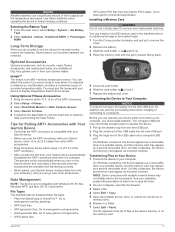
...drives may appear as mounts, maps, fitness accessories, and replacement parts, are available at http: / / buy .garmin .com or from other accessories. Stored data is not lost when batteries are activated and functioning correctly. • When paired, your Garmin device automatically recognizes the ANT ...other ANT + accessories. • Bring the Garmin device within 10 ft. (3 m) of the ANT + accessory. 2 Select Setup > Fitness. 3 Select Heart Rate Monitor or Bike Cadence Sensor. 4 Select Search For New. 5 Customize the data fields to map the drive. 2 On your computer. On ...
...drives may appear as mounts, maps, fitness accessories, and replacement parts, are available at http: / / buy .garmin .com or from other accessories. Stored data is not lost when batteries are activated and functioning correctly. • When paired, your Garmin device automatically recognizes the ANT ...other ANT + accessories. • Bring the Garmin device within 10 ft. (3 m) of the ANT + accessory. 2 Select Setup > Fitness. 3 Select Heart Rate Monitor or Bike Cadence Sensor. 4 Select Search For New. 5 Customize the data fields to map the drive. 2 On your computer. On ...
Owner's Manual
Page 17
...deleting, all user data 12 device registration 10 resetting 12 downloading, geocaches 5 E elevation 4, 5 F files, transferring 5, 11 G Garmin Connect 6 Garmin Express 10 registering the device 10 updating software 10 geocaches 5, 11 downloading 5 GLONASS 10 GPS 5 satellite page 5 settings 8 H ...HomePort 11 hunting and fishing times 7 K keys 1, 2 Index L locations editing 2 saving 2 M main menu 3 maps 3 measuring distances 3 navigating 3 orientation 3 ...
...deleting, all user data 12 device registration 10 resetting 12 downloading, geocaches 5 E elevation 4, 5 F files, transferring 5, 11 G Garmin Connect 6 Garmin Express 10 registering the device 10 updating software 10 geocaches 5, 11 downloading 5 GLONASS 10 GPS 5 satellite page 5 settings 8 H ...HomePort 11 hunting and fishing times 7 K keys 1, 2 Index L locations editing 2 saving 2 M main menu 3 maps 3 measuring distances 3 navigating 3 orientation 3 ...

Quick Start Manual
Page 3
... route, you travel at the top. Navigating a Saved Route Before you can edit a waypoint, you record and store in on the map, select View Map. • To show the elevation plot for each point. The track log contains information about points along the recorded path, including time.... 2 If necessary, select a field to make changes to open the status page. Waypoint names and symbols appear on the map. Changing the Map Orientation 1 From the map, select MENU. 2 Select Setup Map > Orientation. 3 Select an option: • Select North Up to show north at the top of travel , moves and...
... route, you travel at the top. Navigating a Saved Route Before you can edit a waypoint, you record and store in on the map, select View Map. • To show the elevation plot for each point. The track log contains information about points along the recorded path, including time.... 2 If necessary, select a field to make changes to open the status page. Waypoint names and symbols appear on the map. Changing the Map Orientation 1 From the map, select MENU. 2 Select Setup Map > Orientation. 3 Select an option: • Select North Up to show north at the top of travel , moves and...

Quick Start Manual
Page 4
..., you must be limited when the battery is available only on the GPSMAP 64s and GPSMAP 64st. 1 Select Sight 'N Go. 2 Point the device at an object in the distance, lock in the handheld device for Garmin devices. The device may feel warm when the backlight setting is available ...Select the new data field. 5 Follow the on -screen instructions to and lift up. 4 Support and Updates Garmin Express™ provides easy access to these services for additional storage or pre-loaded maps. 1 Turn the D-ring counter-clockwise, and pull up to remove the cover. 2 Remove the battery. 3...
..., you must be limited when the battery is available only on the GPSMAP 64s and GPSMAP 64st. 1 Select Sight 'N Go. 2 Point the device at an object in the distance, lock in the handheld device for Garmin devices. The device may feel warm when the backlight setting is available ...Select the new data field. 5 Follow the on -screen instructions to and lift up. 4 Support and Updates Garmin Express™ provides easy access to these services for additional storage or pre-loaded maps. 1 Turn the D-ring counter-clockwise, and pull up to remove the cover. 2 Remove the battery. 3...


