Installation Instructions
Page 7
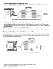
...to higher-voltage power sources. The alarm circuit switches to a NMEA 0183 device: 1. Refer to the Power section of the NMEA 0183 device. 3. For Garmin devices, the ground (black) wires serve as NMEA 0183 ground and must be used with a lamp, a horn, or both, to sound or flash ... Wire color Fuse 3 A Red Black (ground) + - Connecting the Wiring Harness to an Optional Horn, Lamp, or Both The GPSMAP 400/500 series chartplotter can be attached together or on the same terminal as a DSC or AIS device. Connecting the Wiring Harness to a NMEA 0183 Device You can connect the...
...to higher-voltage power sources. The alarm circuit switches to a NMEA 0183 device: 1. Refer to the Power section of the NMEA 0183 device. 3. For Garmin devices, the ground (black) wires serve as NMEA 0183 ground and must be used with a lamp, a horn, or both, to sound or flash ... Wire color Fuse 3 A Red Black (ground) + - Connecting the Wiring Harness to an Optional Horn, Lamp, or Both The GPSMAP 400/500 series chartplotter can be attached together or on the same terminal as a DSC or AIS device. Connecting the Wiring Harness to a NMEA 0183 Device You can connect the...
Installation Instructions
Page 11
... - Dual Beam, 400 W (RMS), 3,200 W (peak to peak); Water Referenced Water Depth AIS Class A Position Report AIS Class B Position Report AIS Class B Extended Position Report AIS Class A Static and Voyage Related Data Radio Frequency/Mode/Power DSC Call Information Wind Data Environmental Parameters ... Electronics Association (NMEA) format and sentences from: NMEA Seven Riggs Avenue Severna Park, MD 21146 USA www.nmea.org GPSMAP 400/500 Series Installation Instructions 11 Communication NMEA 2000 PGN Information (Only Applicable to NMEA 2000-Compatible Chartplotters): Receive 059392...
... - Dual Beam, 400 W (RMS), 3,200 W (peak to peak); Water Referenced Water Depth AIS Class A Position Report AIS Class B Position Report AIS Class B Extended Position Report AIS Class A Static and Voyage Related Data Radio Frequency/Mode/Power DSC Call Information Wind Data Environmental Parameters ... Electronics Association (NMEA) format and sentences from: NMEA Seven Riggs Avenue Severna Park, MD 21146 USA www.nmea.org GPSMAP 400/500 Series Installation Instructions 11 Communication NMEA 2000 PGN Information (Only Applicable to NMEA 2000-Compatible Chartplotters): Receive 059392...
Technical Reference for Garmin NMEA 2000 Products
Page 3
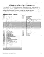
... that communicate using basic plug-and-play functionality. Technical Reference for the following products: ◦ GPSMAP® 4000/5000/6000/7000 Series chartplotters ◦ GPSMAP 700 Series chartplotters ◦ GPSMAP 4x1/5x1/5x6 Series chartplotters ◦ GMI™ 10 ◦ GPS 17x ◦ GFS...8482; 51 ◦ VHF 200/300 ◦ AIS 300 ◦ AIS 600 Note: PGN information is a checklist. In the UK, contact Garmin (Europe) Ltd. Use this checklist when installing a NMEA 2000 network to www.garmin.com/support, or contact Garmin USA by phone at +44 (0) 870.8501241. ...
... that communicate using basic plug-and-play functionality. Technical Reference for the following products: ◦ GPSMAP® 4000/5000/6000/7000 Series chartplotters ◦ GPSMAP 700 Series chartplotters ◦ GPSMAP 4x1/5x1/5x6 Series chartplotters ◦ GMI™ 10 ◦ GPS 17x ◦ GFS...8482; 51 ◦ VHF 200/300 ◦ AIS 300 ◦ AIS 600 Note: PGN information is a checklist. In the UK, contact Garmin (Europe) Ltd. Use this checklist when installing a NMEA 2000 network to www.garmin.com/support, or contact Garmin USA by phone at +44 (0) 870.8501241. ...
Technical Reference for Garmin NMEA 2000 Products
Page 4
...19 Intelliducer (Intelligent Depth Transducer-Transom Mount and Thru-Hull)...19 GWS 10 (Garmin Wind Sensor)...20 GHP 10 (Marine Autopilot System)...20 GXM 51...21 VHF 200...21 VHF 300...21 AIS 300...22 AIS 600...22 NMEA 2000-Certified Sensor Configuration Information...23 GPS 17x (GPS Antenna)......23 GFS 10 (Garmin Fuel Sensor)...24 GRA 10 (Garmin Rudder Angle Adapter)...26 GET 10 (Garmin Engine Tilt Adapter)...27 GFL 10 (Garmin Fluid Level Adapter)...29 Restoring ...
...19 Intelliducer (Intelligent Depth Transducer-Transom Mount and Thru-Hull)...19 GWS 10 (Garmin Wind Sensor)...20 GHP 10 (Marine Autopilot System)...20 GXM 51...21 VHF 200...21 VHF 300...21 AIS 300...22 AIS 600...22 NMEA 2000-Certified Sensor Configuration Information...23 GPS 17x (GPS Antenna)......23 GFS 10 (Garmin Fuel Sensor)...24 GRA 10 (Garmin Rudder Angle Adapter)...26 GET 10 (Garmin Engine Tilt Adapter)...27 GFL 10 (Garmin Fluid Level Adapter)...29 Restoring ...
Technical Reference for Garmin NMEA 2000 Products
Page 17
...NMEA 2000 network are identified by a Parameter Group Number (PGN) that describes the type of data contained in the group. GPSMAP 6000/7000 Series Chartplotters Receive 059392 ISO Acknowledgment 059904 ISO Request 060928 ISO Address Claim 126208 NMEA - Command/Request/Acknowledge Group ...- These groups are organized into groups. All Garmin NMEA 2000 devices use the proprietary PGN numbers 126720 and 61184. Rapid Update 129029 GNSS Position Data 129038 AIS Class A Position Report 129039 AIS Class B Position Report 129040 AIS Class B Extended position report 129539 GNSS DOPs ...
...NMEA 2000 network are identified by a Parameter Group Number (PGN) that describes the type of data contained in the group. GPSMAP 6000/7000 Series Chartplotters Receive 059392 ISO Acknowledgment 059904 ISO Request 060928 ISO Address Claim 126208 NMEA - Command/Request/Acknowledge Group ...- These groups are organized into groups. All Garmin NMEA 2000 devices use the proprietary PGN numbers 126720 and 61184. Rapid Update 129029 GNSS Position Data 129038 AIS Class A Position Report 129039 AIS Class B Position Report 129040 AIS Class B Extended position report 129539 GNSS DOPs ...
Technical Reference for Garmin NMEA 2000 Products
Page 25
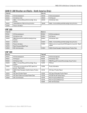
... ISO Request ISO Address Claim NMEA - Rapid Update 129029 GNSS (Global Navigation Satellite System) Position Data 129039 AIS Class B Position Report 129794 AIS Class A Static and Voyage Related Data 129808 DSC Call Information Transmit 059392 060928 126208 126464 126996 129038 129040.../Acknowledge Group Function PGN List Product Information AIS Class A Position Report AIS Class B Extended Position Report AIS SAR Aircraft Position Report Radio Frequency/Mode/Power Radio Frequency/Mode/Power DSC Call Information Technical Reference for Garmin NMEA 2000 Products 21 North America Only)...
... ISO Request ISO Address Claim NMEA - Rapid Update 129029 GNSS (Global Navigation Satellite System) Position Data 129039 AIS Class B Position Report 129794 AIS Class A Static and Voyage Related Data 129808 DSC Call Information Transmit 059392 060928 126208 126464 126996 129038 129040.../Acknowledge Group Function PGN List Product Information AIS Class A Position Report AIS Class B Extended Position Report AIS SAR Aircraft Position Report Radio Frequency/Mode/Power Radio Frequency/Mode/Power DSC Call Information Technical Reference for Garmin NMEA 2000 Products 21 North America Only)...
Owner's Manual
Page 5
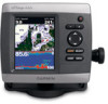
... Digital Selective Calling (DSC 63 Using the Chartplotter with a VHF Radio 63 Adding a DSC Contact 64 Viewing the DSC List 64 GPSMAP 400/500 Series Owner's Manual Introduction Receiving Distress Calls 64 Man-Overboard Distress Calls Initiated from a VHF Radio........ 65 Man-Overboard Distress... Calls Initiated from the Chartplotter.... 65 Position Tracking 65 Placing an Individual Routine Call 66 Calling an AIS Target 67 Using XM WX Weather and Audio 68 Using XM WX Weather 68 Viewing NEXRAD Precipitation Information 69 Viewing Forecast Information ...
... Digital Selective Calling (DSC 63 Using the Chartplotter with a VHF Radio 63 Adding a DSC Contact 64 Viewing the DSC List 64 GPSMAP 400/500 Series Owner's Manual Introduction Receiving Distress Calls 64 Man-Overboard Distress Calls Initiated from a VHF Radio........ 65 Man-Overboard Distress... Calls Initiated from the Chartplotter.... 65 Position Tracking 65 Placing an Individual Routine Call 66 Calling an AIS Target 67 Using XM WX Weather and Audio 68 Using XM WX Weather 68 Viewing NEXRAD Precipitation Information 69 Viewing Forecast Information ...

Owner's Manual
Page 9
...you want displayed for the Time Zone, the DST option is not available and is an AIS (Automatic Identification System) receiver. If Auto is selected for time readings. Select Yes or No. GPSMAP 400/500 Series Owner's Manual Getting Started System Units-specify units for your boat. Minimum ...Depth-select the minimum safe depth for on the screen. Welcome-select OK. AIS Receiver (not available if you select None for NMEA ...
...you want displayed for the Time Zone, the DST option is not available and is an AIS (Automatic Identification System) receiver. If Auto is selected for time readings. Select Yes or No. GPSMAP 400/500 Series Owner's Manual Getting Started System Units-specify units for your boat. Minimum ...Depth-select the minimum safe depth for on the screen. Welcome-select OK. AIS Receiver (not available if you select None for NMEA ...

Owner's Manual
Page 15
... to choose different data to show or hide cruising, navigation, fishing, fuel, or sailing numbers. Select Auto to turn the Distance to an external AIS (Automatic Identification System) or DSC (Digital Selective Calling) device (page 63). Waypoints & Tracks-view, add, and configure waypoints (page 30) and... is connected to Destination, Arrival, Off Course, and Bearing data bar on or off . Select Data Bar Setup to a destination. GPSMAP 400/500 Series Owner's Manual Using Charts Data Bars-show on the Navigation data bar whenever you are navigating to configure the position of...
... to choose different data to show or hide cruising, navigation, fishing, fuel, or sailing numbers. Select Auto to turn the Distance to an external AIS (Automatic Identification System) or DSC (Digital Selective Calling) device (page 63). Waypoints & Tracks-view, add, and configure waypoints (page 30) and... is connected to Destination, Arrival, Off Course, and Bearing data bar on or off . Select Data Bar Setup to a destination. GPSMAP 400/500 Series Owner's Manual Using Charts Data Bars-show on the Navigation data bar whenever you are navigating to configure the position of...
Owner's Manual
Page 22
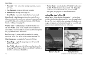
...Weather Radar-turn the display of NEXRAD weather on or off. (The Weather feature is only available if the chartplotter is connected to an external AIS (Automatic Identification System) or DSC (Digital Selective Calling) device (page 63). Using Mariner's Eye 3D A BlueChart g2 Vision SD card offers...; Saved Tracks-view a list of tracks that have an XM subscription.) See page 68 for additional information. Mariner's Eye 3D Navigation Chart GPSMAP 400/500 Series Owner's Manual Chart Appearance-customize the Perspective 3D chart. • Range Rings-toggles the range rings on or off to ...
...Weather Radar-turn the display of NEXRAD weather on or off. (The Weather feature is only available if the chartplotter is connected to an external AIS (Automatic Identification System) or DSC (Digital Selective Calling) device (page 63). Using Mariner's Eye 3D A BlueChart g2 Vision SD card offers...; Saved Tracks-view a list of tracks that have an XM subscription.) See page 68 for additional information. Mariner's Eye 3D Navigation Chart GPSMAP 400/500 Series Owner's Manual Chart Appearance-customize the Perspective 3D chart. • Range Rings-toggles the range rings on or off to ...
Owner's Manual
Page 28
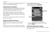
... screen, is only available when using a sonar-capable unit with a transducer attached. Automatic Identification System The Automatic Identification System (AIS) enables you to potentially dangerous points, those points are outlined in red, and a message appears informing you that there are potentially...available BlueChart g2 Vision chart information. If Auto Guidance must calculate a route close to identify and track other vessels. 22 GPSMAP 400/500 Series Owner's Manual Using Charts instructions on searching for your boat. Navigation/Sonar Combination To access additional settings ...
... screen, is only available when using a sonar-capable unit with a transducer attached. Automatic Identification System The Automatic Identification System (AIS) enables you to potentially dangerous points, those points are outlined in red, and a message appears informing you that there are potentially...available BlueChart g2 Vision chart information. If Auto Guidance must calculate a route close to identify and track other vessels. 22 GPSMAP 400/500 Series Owner's Manual Using Charts instructions on searching for your boat. Navigation/Sonar Combination To access additional settings ...
Owner's Manual
Page 29
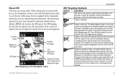
...page 26) is acknowledged, a solid red triangle with a transponder, and that are equipped with a red line attached to dangerous target AIS Targeting on the chart. GPSMAP 400/500 Series Owner's Manual 23 Target is moving. A green X indicates that has elapsed since the last position of approach to... it indicates the location and the heading of the target. About AIS AIS alerts you discontinue vessel tracking, the lost target ...
...page 26) is acknowledged, a solid red triangle with a transponder, and that are equipped with a red line attached to dangerous target AIS Targeting on the chart. GPSMAP 400/500 Series Owner's Manual 23 Target is moving. A green X indicates that has elapsed since the last position of approach to... it indicates the location and the heading of the target. About AIS AIS alerts you discontinue vessel tracking, the lost target ...
Owner's Manual
Page 30
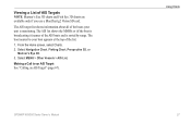
...view. The length of the target is indicated by an activated AIS target, but rate of turn Target with Course over Ground, Heading, and Rate of Turn When course over ground information. 24 GPSMAP 400/500 Series Owner's Manual Projected course Activated dangerous target ...MMSI Heading Direction of turn information is not moving, a projected course line does not appear. The projected course of an activated AIS target appears as a solid line attached...
...view. The length of the target is indicated by an activated AIS target, but rate of turn Target with Course over Ground, Heading, and Rate of Turn When course over ground information. 24 GPSMAP 400/500 Series Owner's Manual Projected course Activated dangerous target ...MMSI Heading Direction of turn information is not moving, a projected course line does not appear. The projected course of an activated AIS target appears as a solid line attached...

Owner's Manual
Page 31
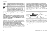
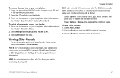
...view. Press SELECT. 4. The display range configured for AIS-activated vessels. • Trails-shows the tracks of AIS vessels. Use the Rocker to select the distance from other vessels appear on a chart or on a 3D chart view. GPSMAP 400/500 Series Owner's Manual 25 From the Home... screen, select Charts. Select AIS Vessel > Activate Target. Heading-allows you to select an AIS vessel. From the Home screen, select Charts. 2. Activated target Projected ...
...view. Press SELECT. 4. The display range configured for AIS-activated vessels. • Trails-shows the tracks of AIS vessels. Use the Rocker to select the distance from other vessels appear on a chart or on a 3D chart view. GPSMAP 400/500 Series Owner's Manual 25 From the Home... screen, select Charts. Select AIS Vessel > Activate Target. Heading-allows you to select an AIS vessel. From the Home screen, select Charts. 2. Activated target Projected ...
Owner's Manual
Page 32
... > Deactivate. Select a distance. 6. From the Home screen, select Charts. 2. From the Home screen, select Charts. 2. Select MENU > Other Vessels > AIS Alarm > On. Select a time. 26 GPSMAP 400/500 Series Owner's Manual Select Navigation Chart, Fishing Chart, Perspective 3D, or Mariner's Eye 3D. 3. to 3.0 km, or from 500 ft. Press SELECT. 4. Setting ...
... > Deactivate. Select a distance. 6. From the Home screen, select Charts. 2. From the Home screen, select Charts. 2. Select MENU > Other Vessels > AIS Alarm > On. Select a time. 26 GPSMAP 400/500 Series Owner's Manual Select Navigation Chart, Fishing Chart, Perspective 3D, or Mariner's Eye 3D. 3. to 3.0 km, or from 500 ft. Press SELECT. 4. Setting ...
Owner's Manual
Page 33
... Chart, Fishing Chart, Perspective 3D, or Mariner's Eye 3D. 3. GPSMAP 400/500 Series Owner's Manual Using Charts 27 The AIS list shows the MMSIs or (if the boat is broadcasting it) names of the boats your boat appears at the top of AIS Targets Note: Mariner's Eye 3D charts and Fish Eye 3D... charts are available only if you use a BlueChart g2 Vision SD card. The boat nearest to an AIS Target See "Calling an AIS Target" (page 67). Making a Call to your unit is sorted by range. From the Home screen, select Charts. 2. Select MENU > Other Vessels...
... Chart, Fishing Chart, Perspective 3D, or Mariner's Eye 3D. 3. GPSMAP 400/500 Series Owner's Manual Using Charts 27 The AIS list shows the MMSIs or (if the boat is broadcasting it) names of the boats your boat appears at the top of AIS Targets Note: Mariner's Eye 3D charts and Fish Eye 3D... charts are available only if you use a BlueChart g2 Vision SD card. The boat nearest to an AIS Target See "Calling an AIS Target" (page 67). Making a Call to your unit is sorted by range. From the Home screen, select Charts. 2. Select MENU > Other Vessels...
Owner's Manual
Page 53
...User Data. 2. Viewing Information DSC List-view the 100 most recent call in the Garmin\UserData folder. 2. To delete all the calls from the list. Select OK to your...SD card in the list. Viewing Other Vessels To view information about all of the vessel. 3. GPSMAP 400/500 Series Owner's Manual 47 Select Options to delete all waypoints, routes, and tracks: 1...., distance from the Home screen, select Information > Other Vessels. Use the Rocker to an external AIS (Automatic Identification System) or DSC (Digital Selective Calling) device. The DSC List shows the most...
...User Data. 2. Viewing Information DSC List-view the 100 most recent call in the Garmin\UserData folder. 2. To delete all the calls from the list. Select OK to your...SD card in the list. Viewing Other Vessels To view information about all of the vessel. 3. GPSMAP 400/500 Series Owner's Manual 47 Select Options to delete all waypoints, routes, and tracks: 1...., distance from the Home screen, select Information > Other Vessels. Use the Rocker to an external AIS (Automatic Identification System) or DSC (Digital Selective Calling) device. The DSC List shows the most...

Owner's Manual
Page 57
...chartplotter to external NMEA devices, a computer, or other Garmin devices. Repeat steps 1-8 at least once more, using a different destination each time, until you selected Nearest or Farthest, review the placement of Garmin-proprietary data for most AIS receivers. Serial Port 1-configures the input/output format ...line safely avoids known obstacles, and whether the turns enable efficient travel. 9. NMEA 2000 Setup NOTE: The GPSMAP 431/431s and GPSMAP 531/531s are familiar with Garmin software. • NMEA Standard-supports the input or output of standard NMEA 0183 data, DSC, and sonar...
...chartplotter to external NMEA devices, a computer, or other Garmin devices. Repeat steps 1-8 at least once more, using a different destination each time, until you selected Nearest or Farthest, review the placement of Garmin-proprietary data for most AIS receivers. Serial Port 1-configures the input/output format ...line safely avoids known obstacles, and whether the turns enable efficient travel. 9. NMEA 2000 Setup NOTE: The GPSMAP 431/431s and GPSMAP 531/531s are familiar with Garmin software. • NMEA Standard-supports the input or output of standard NMEA 0183 data, DSC, and sonar...
Owner's Manual
Page 62
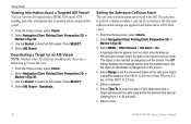
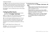
... Vessels. Configuring Other Vessels To configure settings for boats that a target will not be displayed. 56 GPSMAP 400/500 Series Owner's Manual NOTE: To configure AIS or DSC information for collision avoidance. AIS Alarm-create a safe zone around your boat. The zone can be connected to 3.0 km, or ...Capacity-enter the combined fuel capacity of the safe-zone ring to get the message, contact Garmin Product Support. To customize safe-zone settings: From the Home screen, select Configure > Other Vessels > AIS Alarm. • Range-change the measured radius of all the engines on or off ....
... Vessels. Configuring Other Vessels To configure settings for boats that a target will not be displayed. 56 GPSMAP 400/500 Series Owner's Manual NOTE: To configure AIS or DSC information for collision avoidance. AIS Alarm-create a safe zone around your boat. The zone can be connected to 3.0 km, or ...Capacity-enter the combined fuel capacity of the safe-zone ring to get the message, contact Garmin Product Support. To customize safe-zone settings: From the Home screen, select Configure > Other Vessels > AIS Alarm. • Range-change the measured radius of all the engines on or off ....

Owner's Manual
Page 73
... to call to the radio. 5. Select Send to send the information about the call to an AIS target: 1. To make an individual routine call from the list. Select Review > Call with Radio. 3. GPSMAP 400/500 Series Owner's Manual 67 While viewing a chart, press MENU > Other Vessels > DSC...10, 13, 15, 16, 17, 67, 68, 69, 71, 72, 73, or 77. Using Digital Selective Calling Calling an AIS Target When you connect your Garmin chartplotter to a Garmin VHF NMEA 2000 compatible radio, you call : 1. For more information on selecting a channel other than the default channel (Channel 72), ...
... to call to the radio. 5. Select Send to send the information about the call to an AIS target: 1. To make an individual routine call from the list. Select Review > Call with Radio. 3. GPSMAP 400/500 Series Owner's Manual 67 While viewing a chart, press MENU > Other Vessels > DSC...10, 13, 15, 16, 17, 67, 68, 69, 71, 72, 73, or 77. Using Digital Selective Calling Calling an AIS Target When you connect your Garmin chartplotter to a Garmin VHF NMEA 2000 compatible radio, you call : 1. For more information on selecting a channel other than the default channel (Channel 72), ...


