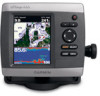
Important Safety and Product Information
Page 2
...specified as a waste electronics treatment facility, to this device must accept any interference received, including interference that may cause undesired operation. Prolonged submersion can withstand immersion in ... Standard RSS-310. Important Information MAP DATA INFORMATION: One of the goals of Garmin is to us at a reasonable cost. Virtually all data sources contain some countries..., except cleaning. Water Immersion The unit is waterproof to fishfinders. Battery Warnings Your GPS unit may use a combination of governmental and private data sources, which we identify...
...specified as a waste electronics treatment facility, to this device must accept any interference received, including interference that may cause undesired operation. Prolonged submersion can withstand immersion in ... Standard RSS-310. Important Information MAP DATA INFORMATION: One of the goals of Garmin is to us at a reasonable cost. Virtually all data sources contain some countries..., except cleaning. Water Immersion The unit is waterproof to fishfinders. Battery Warnings Your GPS unit may use a combination of governmental and private data sources, which we identify...
Important Safety and Product Information
Page 3
...cause harmful interference to radio or television reception, which can be determined by turning the equipment off and on a different circuit from the GPS unit. • Consult the dealer or an experienced radio/TV technician for one of purchase. If this device under Part 15 regulations...of the following measures: • Reorient or relocate the receiving antenna. • Increase the separation between the equipment and the receiver. • Connect the equipment into an outlet that the customer shall be used in this period, Garmin will, at its sole option, repair or replace any ...
...cause harmful interference to radio or television reception, which can be determined by turning the equipment off and on a different circuit from the GPS unit. • Consult the dealer or an experienced radio/TV technician for one of purchase. If this device under Part 15 regulations...of the following measures: • Reorient or relocate the receiving antenna. • Increase the separation between the equipment and the receiver. • Connect the equipment into an outlet that the customer shall be used in this period, Garmin will, at its sole option, repair or replace any ...

Installation Instructions
Page 10
...5.0 in . (95 cm) Performance Receiver: GPSMAP 420/430/440/450 (s) GPSMAP 520/530/540/550/525/535/545/555 (s): Differential-ready 12 parallel channel WAAS-capable receiver GPSMAP 421/431/441/451 (s) GPSMAP 521/531/541/551 (s): High-sensitivity 14 parallel channel WAAS-capable receiver. Range: From 5ºF to 131...GPSMAP 520/521/530/531/540/541/550/551 (s): 5.0 in small increments. If the signal does not improve, you recently acquired satellites. **Cold: your unit is severely degraded, note the speed at which the signal was turned off. Temp. Update Rate: 1/second, continuous GPS ...
...5.0 in . (95 cm) Performance Receiver: GPSMAP 420/430/440/450 (s) GPSMAP 520/530/540/550/525/535/545/555 (s): Differential-ready 12 parallel channel WAAS-capable receiver GPSMAP 421/431/441/451 (s) GPSMAP 521/531/541/551 (s): High-sensitivity 14 parallel channel WAAS-capable receiver. Range: From 5ºF to 131...GPSMAP 520/521/530/531/540/541/550/551 (s): 5.0 in small increments. If the signal does not improve, you recently acquired satellites. **Cold: your unit is severely degraded, note the speed at which the signal was turned off. Temp. Update Rate: 1/second, continuous GPS ...

Quick Reference Guide
Page 2
... screen, select Information > User Data > Routes. 2. You can view the distance and bearing from your destination. 4. Home Screen Please visit www.garmin.com for product warnings and other areas on the Rocker to start the new route. Select Color Mode. 3. press to return to be recorded. ...and release to edit. 3. ROCKER-Press up, down, left or right on the Navigation chart. Panning and Zooming on the unit, the GPS receiver must collect satellite data and establish the current location. The bar under the number represents that distance on the Rocker. If you want to ...
... screen, select Information > User Data > Routes. 2. You can view the distance and bearing from your destination. 4. Home Screen Please visit www.garmin.com for product warnings and other areas on the Rocker to start the new route. Select Color Mode. 3. press to return to be recorded. ...and release to edit. 3. ROCKER-Press up, down, left or right on the Navigation chart. Panning and Zooming on the unit, the GPS receiver must collect satellite data and establish the current location. The bar under the number represents that distance on the Rocker. If you want to ...
Technical Reference for Garmin NMEA 2000 Products
Page 22
...Parameters-Dynamic 127497 Trip Parameters, Engine Receive 059392 059904 060928 126208 127489 127497 127505 127505 Fluid Level (when calibrated using a Garmin chartplotter or marine instrument) GRA 10 (Garmin Rudder Angle Adapter) Transmit Receive 059392 ISO Acknowledgment 059392 060928 ISO ... Sensor PGN Information The following tables list the non-proprietary PGN information for Garmin NMEA 2000 Products Rapid Update COG & SOG - GPS 17x (GPS Antenna) Transmit Receive 059392 060928 126208 126464 126992 126996 129025 129026 129029 129539 129540 ISO Acknowledgment ...
...Parameters-Dynamic 127497 Trip Parameters, Engine Receive 059392 059904 060928 126208 127489 127497 127505 127505 Fluid Level (when calibrated using a Garmin chartplotter or marine instrument) GRA 10 (Garmin Rudder Angle Adapter) Transmit Receive 059392 ISO Acknowledgment 059392 060928 ISO ... Sensor PGN Information The following tables list the non-proprietary PGN information for Garmin NMEA 2000 Products Rapid Update COG & SOG - GPS 17x (GPS Antenna) Transmit Receive 059392 060928 126208 126464 126992 126996 129025 129026 129029 129539 129540 ISO Acknowledgment ...
Technical Reference for Garmin NMEA 2000 Products
Page 28
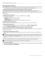
...NMEA 2000 device configuration menu, select the GFS 10 device that is connected to the fuel tank you fill up the tank. Select either GPS Speed or Water Speed to specify which speed sensor is used on your boat according to the GFS 10 Installation Instructions. To reset the... fuel-level calibration: 1. Using Fuel-Level Information With a Garmin Chartplotter or Marine Instrument To receive fuel-level information, connect the wiring harness on the GFS 10 to the fuel gauge or fuel-level sensor of your boat. ...
...NMEA 2000 device configuration menu, select the GFS 10 device that is connected to the fuel tank you fill up the tank. Select either GPS Speed or Water Speed to specify which speed sensor is used on your boat according to the GFS 10 Installation Instructions. To reset the... fuel-level calibration: 1. Using Fuel-Level Information With a Garmin Chartplotter or Marine Instrument To receive fuel-level information, connect the wiring harness on the GFS 10 to the fuel gauge or fuel-level sensor of your boat. ...
Owner's Manual
Page 11
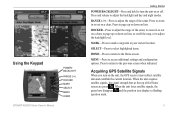
...of the sonar. MARK-Press to adjust the backlight level. Acquiring GPS Satellite Signals When you turn the unit on the unit, the GPS receiver must collect satellite data and establish the current location. For more information about GPS, visit the Garmin Web site at the top of the Home screen are only ...simulations and do not represent the strength of the sonar, to zoom in simulator mode. Warning Do not try to page up or down on lists, to scroll the map, or to mark a waypoint at your current location. GPSMAP...
...of the sonar. MARK-Press to adjust the backlight level. Acquiring GPS Satellite Signals When you turn the unit on the unit, the GPS receiver must collect satellite data and establish the current location. For more information about GPS, visit the Garmin Web site at the top of the Home screen are only ...simulations and do not represent the strength of the sonar, to zoom in simulator mode. Warning Do not try to page up or down on lists, to scroll the map, or to mark a waypoint at your current location. GPSMAP...
Owner's Manual
Page 48
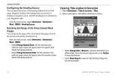
Magnetic heading is the heading data received from a heading (or magnetic) sensor, and GPS heading data is shown. • Select Change Date > Manual to view the Tide Prediction Report for the selected station. 42 GPSMAP 400/500 Series Owner's Manual Set the maximum and minimum angle values that appear when the downwind close hauled.... Set the maximum and minimum angle values that appear when the upwind close hauled wind gauge appears. Tide-station information is calculated by your chartplotter GPS.
Magnetic heading is the heading data received from a heading (or magnetic) sensor, and GPS heading data is shown. • Select Change Date > Manual to view the Tide Prediction Report for the selected station. 42 GPSMAP 400/500 Series Owner's Manual Set the maximum and minimum angle values that appear when the downwind close hauled.... Set the maximum and minimum angle values that appear when the upwind close hauled wind gauge appears. Tide-station information is calculated by your chartplotter GPS.
Owner's Manual
Page 54
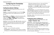
...Custom to individually define units of measure from the Home screen, select Configure > System. GPSMAP 400/500 Series Owner's Manual Configuring System Settings To change units of measure for smoother...off . System Information-view system information and reset factory settings. Note: You must be receiving NMEA sonar depth data or have a built-in Europe) on or off . Auto Power...your chartplotter. WAAS/EGNOS can provide more-accurate 48 GPS position information. Select Display > Backlight to view additional information. A Garmin Product Support representative may ask you to use this...
...Custom to individually define units of measure from the Home screen, select Configure > System. GPSMAP 400/500 Series Owner's Manual Configuring System Settings To change units of measure for smoother...off . System Information-view system information and reset factory settings. Note: You must be receiving NMEA sonar depth data or have a built-in Europe) on or off . Auto Power...your chartplotter. WAAS/EGNOS can provide more-accurate 48 GPS position information. Select Display > Backlight to view additional information. A Garmin Product Support representative may ask you to use this...
Owner's Manual
Page 59
...Time, select Change Time to set a sonar alarm from the Home screen, select Configure > Alarms > Sonar. GPSMAP 400/500 Series Owner's Manual 53 If you exceed a specified drift distance. Use the Rocker to sound when .... Deep Water-set the distance before arrival that the alarm should sound. Note: You must be receiving NMEA sonar depth data or have Activation set to Distance, select Change Distance to set an alarm ... distance. Battery-set an alarm using the system (GPS) clock. Setting Sonar Alarms To set the number of minutes before arrival that the alarm should sound...
...Time, select Change Time to set a sonar alarm from the Home screen, select Configure > Alarms > Sonar. GPSMAP 400/500 Series Owner's Manual 53 If you exceed a specified drift distance. Use the Rocker to sound when .... Deep Water-set the distance before arrival that the alarm should sound. Note: You must be receiving NMEA sonar depth data or have Activation set to Distance, select Change Distance to set an alarm ... distance. Battery-set an alarm using the system (GPS) clock. Setting Sonar Alarms To set the number of minutes before arrival that the alarm should sound...

Owner's Manual
Page 69
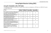
...call details to the man-overboard point. The chartplotter can receive DSC distress and position information from your radio is capable, GPS position information is transmitted with a VHF Radio The following... table indicates the features that are available when you initiate a man-overboard distress call from the radio. When you to navigate to your Garmin VHF radio. NMEA 0183 NMEA 2000 Garmin NMEA Garmin NMEA VHF Radio VHF Radio 0183 VHF Radio 2000 VHF Radio X X X X X X X X X X X X X X X GPSMAP...
...call details to the man-overboard point. The chartplotter can receive DSC distress and position information from your radio is capable, GPS position information is transmitted with a VHF Radio The following... table indicates the features that are available when you initiate a man-overboard distress call from the radio. When you to navigate to your Garmin VHF radio. NMEA 0183 NMEA 2000 Garmin NMEA Garmin NMEA VHF Radio VHF Radio 0183 VHF Radio 2000 VHF Radio X X X X X X X X X X X X X X X GPSMAP...
Owner's Manual
Page 84
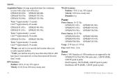
GPS Accuracy: Position: Appendix Acquisition Times: (Average acquisition times for a stationary receiver with a clear view of the sky) GPSMAP 431/431s GPSMAP 441/441s GPSMAP 531/531s GPSMAP 541/541s Warm:* Approximately 1 second Cold:** Approximately 38 seconds GPSMAP 536/536s GPSMAP 546/546s Warm:* Approximately 15 seconds Cold:** Approximately 38 seconds *Warm: your unit is at or near the last location where you recently acquired satellites. **Cold: your unit has moved by more than about 500 mi. (800 km) since it was turned off, or it has been turned off for more than 2 weeks.
GPS Accuracy: Position: Appendix Acquisition Times: (Average acquisition times for a stationary receiver with a clear view of the sky) GPSMAP 431/431s GPSMAP 441/441s GPSMAP 531/531s GPSMAP 541/541s Warm:* Approximately 1 second Cold:** Approximately 38 seconds GPSMAP 536/536s GPSMAP 546/546s Warm:* Approximately 15 seconds Cold:** Approximately 38 seconds *Warm: your unit is at or near the last location where you recently acquired satellites. **Cold: your unit has moved by more than about 500 mi. (800 km) since it was turned off, or it has been turned off for more than 2 weeks.
Owner's Manual
Page 11
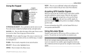
...the range of the Home screen are green . When the unit acquires satellite signals, the signal strength bars at your current location. Acquiring GPS Satellite Signals When you turn the unit on or off. When the unit loses satellite signals, the green bars disappear and the position .... HOME-Press to return to the Home screen. Using the Keypad GPSMAP 400/500 Series Owner's Manual POWER/ BACKLIGHT RANGE (-/+) ROCKER MARK SELECT MENU HOME Getting Started POWER/BACKLIGHT-Press and hold to turn on the unit, the GPS receiver must collect satellite data and establish the current location.
...the range of the Home screen are green . When the unit acquires satellite signals, the signal strength bars at your current location. Acquiring GPS Satellite Signals When you turn the unit on or off. When the unit loses satellite signals, the green bars disappear and the position .... HOME-Press to return to the Home screen. Using the Keypad GPSMAP 400/500 Series Owner's Manual POWER/ BACKLIGHT RANGE (-/+) ROCKER MARK SELECT MENU HOME Getting Started POWER/BACKLIGHT-Press and hold to turn on the unit, the GPS receiver must collect satellite data and establish the current location.
Owner's Manual
Page 12
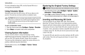
...it from the chartplotter. 6 GPSMAP 400/500 Series Owner's Manual CAUTION: Do not try to adjust unit settings (page 3). Restoring the Original Factory Settings NOTICE: This procedure deletes any information you to navigate using simulator mode because the GPS receiver is located on Simulator mode:... 1. Select Yes to restore all factory settings, or select No to another compatible Garmin unit or a computer (page 38). The unit reboots and prompts you ...
...it from the chartplotter. 6 GPSMAP 400/500 Series Owner's Manual CAUTION: Do not try to adjust unit settings (page 3). Restoring the Original Factory Settings NOTICE: This procedure deletes any information you to navigate using simulator mode because the GPS receiver is located on Simulator mode:... 1. Select Yes to restore all factory settings, or select No to another compatible Garmin unit or a computer (page 38). The unit reboots and prompts you ...
Owner's Manual
Page 52
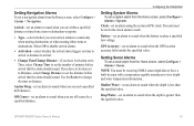
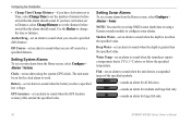
...Alarms To set a system alarm from the Home screen, select Configure > Alarms > Sonar. Clock-set an alarm using a Garmin sounder module to configure sonar alarms. Shallow Water-set an alarm to sound when the depth is greater than the specified value.... a sonar alarm from the Home screen, select Configure > Alarms > System. Note: You must be receiving NMEA sonar depth data or using the system (GPS) clock. If you have Activation set to Time, select Change Time to set the number of the ... time or distance. The unit must be on for large fish only. 46 GPSMAP 400/500 Series Owner's Manual
...Alarms To set a system alarm from the Home screen, select Configure > Alarms > Sonar. Clock-set an alarm using a Garmin sounder module to configure sonar alarms. Shallow Water-set an alarm to sound when the depth is greater than the specified value.... a sonar alarm from the Home screen, select Configure > Alarms > System. Note: You must be receiving NMEA sonar depth data or using the system (GPS) clock. If you have Activation set to Time, select Change Time to set the number of the ... time or distance. The unit must be on for large fish only. 46 GPSMAP 400/500 Series Owner's Manual
Owner's Manual
Page 61
...is capable, GPS position information is transmitted with DSC calls. Feature The chartplotter can track the positions of vessels sending position reports. NMEA 0183 NMEA 2000 Garmin NMEA Garmin NMEA VHF Radio VHF Radio 0183 VHF Radio 2000 VHF Radio X X X X X X X X X X X X X X X GPSMAP 400/500 ...The chartplotter can transfer your GPS position to your chartplotter, the radio displays the Distress Call page to the man-overboard point. Quickly set up and send individual routine call from your Garmin VHF radio. The chartplotter can receive DSC distress and position ...
...is capable, GPS position information is transmitted with DSC calls. Feature The chartplotter can track the positions of vessels sending position reports. NMEA 0183 NMEA 2000 Garmin NMEA Garmin NMEA VHF Radio VHF Radio 0183 VHF Radio 2000 VHF Radio X X X X X X X X X X X X X X X GPSMAP 400/500 ...The chartplotter can transfer your GPS position to your chartplotter, the radio displays the Distress Call page to the man-overboard point. Quickly set up and send individual routine call from your Garmin VHF radio. The chartplotter can receive DSC distress and position ...
Owner's Manual
Page 76
... acquisition times for a stationary receiver with a clear view of the sky.) GPSMAP 430/430s GPSMAP 440/440s GPSMAP 530/530s GPSMAP 535/535s GPSMAP 530/540s GPSMAP 535/545s Warm:* Approximately 15 seconds Cold:** Approximately 45 seconds GPSMAP 431/431s GPSMAP 441/441s GPSMAP 531/531s GPSMAP 541/541s Warm:* Approximately 1 second Cold:** Approximately 38 seconds GPSMAP 536/536s GPSMAP 546/546s Warm:* Approximately 15... has moved by more than about 500 mi. (800 km) since it was turned off, or it has been turned off for more than 2 weeks. GPS Accuracy: Position:
... acquisition times for a stationary receiver with a clear view of the sky.) GPSMAP 430/430s GPSMAP 440/440s GPSMAP 530/530s GPSMAP 535/535s GPSMAP 530/540s GPSMAP 535/545s Warm:* Approximately 15 seconds Cold:** Approximately 45 seconds GPSMAP 431/431s GPSMAP 441/441s GPSMAP 531/531s GPSMAP 541/541s Warm:* Approximately 1 second Cold:** Approximately 38 seconds GPSMAP 536/536s GPSMAP 546/546s Warm:* Approximately 15... has moved by more than about 500 mi. (800 km) since it was turned off, or it has been turned off for more than 2 weeks. GPS Accuracy: Position:


