Installation Instructions
Page 8
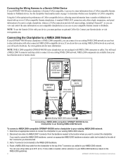
... Existing NMEA 2000 Network To connect a NMEA 2000-compatible GPSMAP 400/500 series chartplotter to your Garmin dealer, or visit www.garmin.com. Add a T-connector (not included) to your existing NMEA 2000 network. 2. Route a NMEA 2000 drop cable from a sounder or fishfinder to be sent to a single chartplotter, whereas a CANet connection provides full sonar readings, including...
... Existing NMEA 2000 Network To connect a NMEA 2000-compatible GPSMAP 400/500 series chartplotter to your Garmin dealer, or visit www.garmin.com. Add a T-connector (not included) to your existing NMEA 2000 network. 2. Route a NMEA 2000 drop cable from a sounder or fishfinder to be sent to a single chartplotter, whereas a CANet connection provides full sonar readings, including...
Installation Instructions
Page 9
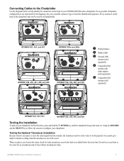
... screens to configure your GPSMAP 400/500 series chartplotter. Connecting Cables to the Chartplotter Use the diagrams below the water line. Testing the Optional Transducer Installation Because water is necessary to carry the sonar signal from the sounder, the transducer must be used for all installations. ➋ ➌ ➌ ➊➎ GPSMAP 421, 441, and 451...
... screens to configure your GPSMAP 400/500 series chartplotter. Connecting Cables to the Chartplotter Use the diagrams below the water line. Testing the Optional Transducer Installation Because water is necessary to carry the sonar signal from the sounder, the transducer must be used for all installations. ➋ ➌ ➌ ➊➎ GPSMAP 421, 441, and 451...
Owner's Manual
Page 56
... > Auto Guidance > Shoreline Distance > Farthest. • If the turns in step 7, review the placement of the Auto Guidance line. GPSMAP 400/500 Series Owner's Manual Determine whether the line safely avoids known obstacles, and whether the turns enable efficient travel . 9. Repeat steps...data for most AIS receivers. Configuring the Chartplotter 8. Determine whether the line safely avoids known obstacles, and whether the turns enable efficient travel . 11. Serial Port 1-configures the input/output format for sounder, route, system, and Garmin NMEA settings. From the Home screen, ...
... > Auto Guidance > Shoreline Distance > Farthest. • If the turns in step 7, review the placement of the Auto Guidance line. GPSMAP 400/500 Series Owner's Manual Determine whether the line safely avoids known obstacles, and whether the turns enable efficient travel . 9. Repeat steps...data for most AIS receivers. Configuring the Chartplotter 8. Determine whether the line safely avoids known obstacles, and whether the turns enable efficient travel . 11. Serial Port 1-configures the input/output format for sounder, route, system, and Garmin NMEA settings. From the Home screen, ...
Owner's Manual
Page 57
Select a setting (Sounder, Route, System, or Garmin). 3. Configuring the Chartplotter To label engines as numbers: 1. From the Home screen, select Configure > Communications > NMEA 2000 Setup > Label Devices > Change Engine Labels > Label Type ...(A). 4. To label tanks as numbers: From the Home screen, select Configure > Communications > NMEA 2000 Setup > Label Devices > Change Engine Labels > Use Numbers. GPSMAP 400/500 Series Owner's Manual 51 2. Select a tank. 3. If a NMEA 2000 device has configuration options or settings, select the device for the tank. Select ...
Select a setting (Sounder, Route, System, or Garmin). 3. Configuring the Chartplotter To label engines as numbers: 1. From the Home screen, select Configure > Communications > NMEA 2000 Setup > Label Devices > Change Engine Labels > Label Type ...(A). 4. To label tanks as numbers: From the Home screen, select Configure > Communications > NMEA 2000 Setup > Label Devices > Change Engine Labels > Use Numbers. GPSMAP 400/500 Series Owner's Manual 51 2. Select a tank. 3. If a NMEA 2000 device has configuration options or settings, select the device for the tank. Select ...


