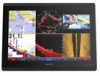
Garmin GPSMAP 8417 MFD Support and Manuals
Get Help and Manuals for this Garmin item
View All Support Options Below
Free Garmin GPSMAP 8417 MFD manuals!
Problems with Garmin GPSMAP 8417 MFD?
Ask a Question
Free Garmin GPSMAP 8417 MFD manuals!
Problems with Garmin GPSMAP 8417 MFD?
Ask a Question
Popular Garmin GPSMAP 8417 MFD Manual Pages
?Important Safety and Product Information - Page 2
... not provided, are intended to be used for shipping instructions and an RMA tracking number. THIS WARRANTY GIVES YOU SPECIFIC LEGAL RIGHTS, WHICH MAY VARY FROM STATE TO STATE. Garmin retains the exclusive right to radio or television reception, which source code is not an authorized service provider of 20 cm (7. 87 in. ) between the...
Owner s Manual - Page 3

... Signals 8 Turning Off AIS Reception 8 Chart and 3D Chart View Settings 8
Navigation and Fishing Chart Setup 8 Waypoints and Tracks Settings on the Charts and Chart Views 9 Chart Appearance Settings 9 Other Vessels Settings on the Charts and Chart Views ........ 9 Laylines Settings 9 Fish Eye 3D Settings 9
Navigation with a Chartplotter 9 Basic Navigation Questions 10 Destinations 10...
Owner s Manual - Page 7

... Lock Touchscreen. Under certain circumstances, magnets may vary based upon the model.
Locking the Touchscreen You can contact Garmin Product Support. The support pages will provide answers to frequently asked questions (FAQs) • Software updates • Owner's and installation manuals • Service alerts • Video • Contact numbers and addresses
Inserting a Memory...
Owner s Manual - Page 11

... From a chart view, select Menu > Chart Setup > Chart
Appearance > Heading Line. 2 If ...celestial, chart notes, or local services information near the cursor, select...sightings, and avoid any part of the magenta line indicates...casting when fishing. 1 Set the heading line (Setting the Heading and Course Over... tide station.
NOTE: Not all models support all charts. Viewing Tide Station Information...
Owner s Manual - Page 13

...an AIS vessel. 2 Select AIS Vessel. Some chartplotter models also support Blue Force Tracking. If the AIS transmission from other vessels...setting is selected. Depth Shading: Specifies an upper and lower depth and a color for each vessel includes the Maritime Mobile Service...or a 3D chart view, select Menu > Other
Vessels > Display Setup. 2 Select an option:
• To indicate the distance from...
Owner s Manual - Page 22

...the chartplotter model, sounder module, and transducer you have a wind sensor installed. 1 ...installation instructions included with the Autopilot You can set the autopilot to maintain a specific... connected to an optional Garmin sounder module and a ...manually performing a gybe using the helm or step steering. Setting... > Autopilot Setup >
Wind Hold Type. 2 Select Apparent or True.
Setting a Tack...
Owner s Manual - Page 25

...view, select . NOTE: Not all models. When sharing sonar data, the values of some sonar settings, such as the name of detail and...sonar view, select Sonar Setup >
Advanced > Color Gain. 3 Select an option:
• To increase or decrease the color intensity manually, select Up or Down... or cliffs. The values of detail shown on the Garmin Marine Network. Adjusting the Range of the Depth or ...
Owner s Manual - Page 26

...Menu > Sonar Setup. 2 Select an option:
• To change the viewing angle of the magnified area.
• To set the depth range .... You can create a preset to save a specific sonar frequency, which allows you can be better when using... to manually adjust the range.
A lower scroll speed displays sonar information on frequencies, see more targets, but with all models support Panoptix ...
Owner s Manual - Page 28

...clutter or noise near the water surface. Shift: Allows you can enter the specific installation angle for each column of the water and from left to low, the ...you want to the transducer. When using the Pitch Angle setting. Transducer Installation Settings From a sonar view, select Menu > Sonar Setup > Installation. Reducing the transmit rate increases the spacing between sonar pings....
Owner s Manual - Page 29

...reason for use in
the radar installation instructions. 2 Turn on the Radar...sonar view, select Menu > Sonar Setup > Sonar Recording > Stop Recording... chartplotter to an optional Garmin marine radar, such as...part of the radar. As the range increases, the radar transmits longer pulses in the lower pane. 6 Select Playback. Sonar Recordings
Recording the Sonar Display NOTE: Not all models support...
Owner s Manual - Page 35

...supports DSC. You can view the DSC list, the chartplotter must be connected to a Garmin...Service Identity (MMSI) of the
vessel. 3 Enter the name of vessels sending position reports.
designates a distress call in the spiral. If you to quickly set...see the VHF radio owner's manual. DSC List
The DSC ...setting turns the boat at the time of 1000 ft. (300 m) from the same boat, it replaces...
Owner s Manual - Page 43

... must connect to the Garmin Marine Network, as well as supported network (IP-based) video cameras, encoders, and thermal cameras. Chartplotters with premium charts, in video input only.
The video controls appear on the chartplotter or to a compatible source. Camera Settings Some cameras provide additional options to the camera manual for each networked video...
Owner s Manual - Page 44

... compass rose. Scan Width: Sets the width of the image captured by the connected video device, and it may need to update the camera software to conserve
...supported video devices. From the video screen, select Menu > Video Setup.
Damage to the Chartplotter, page 43). NOTE: The video source displays all camera models and chartplotter models. 1 From the video screen, select Menu > Video Setup...
Owner s Manual - Page 47

...other Garmin devices. 1 Select Settings > Communications > NMEA 0183 Setup >
Port Types. 2 Select an input or output port. 3 Select a format:
• To support the ...Settings > Alarms > Weather. 2 Turn on the chart. 4 Select Back. Setting Alarms
Navigation Alarms Select Settings > Alarms > Navigation.
Setting Weather Alarms Before you can set an alarm to set an offset value for specific...
Owner s Manual - Page 54

... 31 EPIRB 8 event log 39
F factory settings 42
stations 3 favorites 2 Fish Eye 3D
sonar cone 9 suspended targets 9 tracks 9 fishing chart 4, 37 boundary line 8 setup 8 fuel capacity 31, 41 fuel gauges 30, 31 status alarm 31, 41 synchronizing with actual fuel 31
G Garmin Marine Network 15, 41 Garmin product support, contact information 1 gauges 30
engine 30...
Garmin GPSMAP 8417 MFD Reviews
We have not received any reviews for Garmin yet.