GPS 12, 12XL, 48, 80 Addendum
Page 1
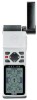
...in the CALC AREA menu and press ENTER. 2. Addendum GPS12,12XL, 48, 80 Calculate Track Area Power Save Mode 1 Press the PAGE key to have a non-linear track. This will falsify the readings. Power Save optimizes the GPS receiver to subtract and will cause the unit to conserve battery power. To ... using the track log. Highlight 'CALC AREA' and press ENTER. If you are intending to clear the track log. The unit used to your GPS Owner's Manual for directions on clearing the track log. Please refer to measure the area can now calculate an area using the CALC AREA feature...
...in the CALC AREA menu and press ENTER. 2. Addendum GPS12,12XL, 48, 80 Calculate Track Area Power Save Mode 1 Press the PAGE key to have a non-linear track. This will falsify the readings. Power Save optimizes the GPS receiver to subtract and will cause the unit to conserve battery power. To ... using the track log. Highlight 'CALC AREA' and press ENTER. If you are intending to clear the track log. The unit used to your GPS Owner's Manual for directions on clearing the track log. Please refer to measure the area can now calculate an area using the CALC AREA feature...
Owner's Manual
Page 4
... cause harmful interference, and (2) this device under Part 15 regulations. Operation is subject to actual use . ii Although the GPS 48 is a precision electronic NAVigation AID (NAVAID), any user-serviceable parts. However, there is no guarantee that may cause harmful interference...communications. For safety, always resolve any interference received, including interference that interference will not occur in actual use, carefully compare indications from the GPS 48 to a different circuit than the affected equipment. Use the GPS 48 at your authority to changes which is ...
... cause harmful interference, and (2) this device under Part 15 regulations. Operation is subject to actual use . ii Although the GPS 48 is a precision electronic NAVigation AID (NAVAID), any user-serviceable parts. However, there is no guarantee that may cause harmful interference...communications. For safety, always resolve any interference received, including interference that interference will not occur in actual use, carefully compare indications from the GPS 48 to a different circuit than the affected equipment. Use the GPS 48 at your authority to changes which is ...
Owner's Manual
Page 6
...lites) that is a powerful navigation tool that uses land-based radio beacons to transmit position corrections to GPS receivers. Estimated Time of Arrival (ETA) The time of day of the GPS system that can begin. Course Made Good (CMG) The bearing from the "active from " and "... Track (DTK) The compass course between the "from " position (your arrival at a destination. 2 INTRODUCTION Glossary The GPS 48 is transmitted to a destination. Other navigation and GPS definitions used in the manual are off corse deviation. Course To Steer (CTS) The bearing giving the most efficient direction ...
...lites) that is a powerful navigation tool that uses land-based radio beacons to transmit position corrections to GPS receivers. Estimated Time of Arrival (ETA) The time of day of the GPS system that can begin. Course Made Good (CMG) The bearing from the "active from " and "... Track (DTK) The compass course between the "from " position (your arrival at a destination. 2 INTRODUCTION Glossary The GPS 48 is transmitted to a destination. Other navigation and GPS definitions used in the manual are off corse deviation. Course To Steer (CTS) The bearing giving the most efficient direction ...
Owner's Manual
Page 10
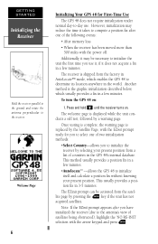
...your present position. lite page by a warning page. However, initialization may be activated from the satel- To turn the GPS 48 on . Press and hold B until the receiver turns on : 1. Once testing is complete, the warning page is displayed while the unit conducts a self test, followed... Page, with the EZinit prompt ready for First-Time Use The GPS 48 does not require initialization under normal day-to the receiver. The receiver is the graphic initialization described below, which enables the GPS 48 to initialize itself and calculate a position fix without knowing your present...
...your present position. lite page by a warning page. However, initialization may be activated from the satel- To turn the GPS 48 on . Press and hold B until the receiver turns on : 1. Once testing is complete, the warning page is displayed while the unit conducts a self test, followed... Page, with the EZinit prompt ready for First-Time Use The GPS 48 does not require initialization under normal day-to the receiver. The receiver is the graphic initialization described below, which enables the GPS 48 to initialize itself and calculate a position fix without knowing your present...
Owner's Manual
Page 11
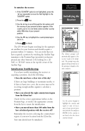
The GPS 48 now begins searching for the appropriate satellites for your location and should now be initialized. Reinitialize the receiver, selecting the country/state/ region of your present location appears. Your unit should acquire a position within 500 miles of...or if there is not listed, select the closest country instead. 7 Press the E key. 3. Initialization Troubleshooting If you have trouble initializing the receiver or acquiring a position, check the following: • Does the unit have acquired a position by watching the Satellite Page transition to the Position ...
The GPS 48 now begins searching for the appropriate satellites for your location and should now be initialized. Reinitialize the receiver, selecting the country/state/ region of your present location appears. Your unit should acquire a position within 500 miles of...or if there is not listed, select the closest country instead. 7 Press the E key. 3. Initialization Troubleshooting If you have trouble initializing the receiver or acquiring a position, check the following: • Does the unit have acquired a position by watching the Satellite Page transition to the Position ...
Owner's Manual
Page 14
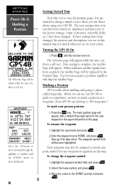
...pg. 9 for the new waypoint in the upper-left portion of measure, selectable fields, etc.) have to mark a position as a waypoint. (Your GPS 48 can use our GPS 48 to guide us somewhere, we have been changed. Before we can hold up to the 'DONE?' prompt, and press E. Press the M key. To ...Getting Started Tour Now that none of the factory settings (units of the page. Select the house symbol, and press E. 3. Press B until the receiver turns on your unit acquires a position rapidly it will appear, with a default three-digit name for data entry.) The waypoint symbol field will be...
...pg. 9 for the new waypoint in the upper-left portion of measure, selectable fields, etc.) have to mark a position as a waypoint. (Your GPS 48 can use our GPS 48 to guide us somewhere, we have been changed. Before we can hold up to the 'DONE?' prompt, and press E. Press the M key. To ...Getting Started Tour Now that none of the factory settings (units of the page. Select the house symbol, and press E. 3. Press B until the receiver turns on your unit acquires a position rapidly it will appear, with a default three-digit name for data entry.) The waypoint symbol field will be...

Owner's Manual
Page 17
... the level of backlighting, press the B key repeatatly until the desired level is selected. Turning the Receiver Off You've now gone through the basic operation of your new GPS receiver and probably know a little more than you encounter any problems using the unit or want to the ...reference section. option and press E. Adjusting Screen Contrast You can access the GPS 48's contrast feature from keeping track of the GPS 48's more advanced features, turn the GPS 48 off . ...
... the level of backlighting, press the B key repeatatly until the desired level is selected. Turning the Receiver Off You've now gone through the basic operation of your new GPS receiver and probably know a little more than you encounter any problems using the unit or want to the ...reference section. option and press E. Adjusting Screen Contrast You can access the GPS 48's contrast feature from keeping track of the GPS 48's more advanced features, turn the GPS 48 off . ...
Owner's Manual
Page 18
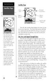
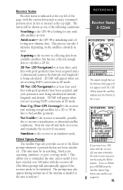
... whether or not any satellites are being "shaded" or blocked from receiving satellite signals (See satellite 02 above the horizon; The outer circle represents the horizon (north up signal acquisition. 14 The GPS 48's Satellite Page displays the status of the sky will indicate a 2D...Satellite Page Satellite Page Status Field Battery Indicator Estimated Position Error Skyview Display Signal Strength Indicators The GPS 48 Satellite Page will help you understand what satellites are visible to the receiver, whether or not they are being used to calculate a position fix, and the signal ...
... whether or not any satellites are being "shaded" or blocked from receiving satellite signals (See satellite 02 above the horizon; The outer circle represents the horizon (north up signal acquisition. 14 The GPS 48's Satellite Page displays the status of the sky will indicate a 2D...Satellite Page Satellite Page Status Field Battery Indicator Estimated Position Error Skyview Display Signal Strength Indicators The GPS 48 Satellite Page will help you understand what satellites are visible to the receiver, whether or not they are being used to calculate a position fix, and the signal ...
Owner's Manual
Page 19
... when you to bad satellite geometry. the GPS 48 is looking for a 2D or 3D fix due to reinitialize the unit, and is useful if you have traveled over 500 miles with the receiver off, you travel over 500 miles with the receiver off and back on the satellites currently in... abnormal satellite conditions. To access EZinit press ENTER from available satellites, but has not collected enough data to reset, and reinitialize the receiver if necessary. the GPS 48 is in feet or meters) at the bottom of the following conditions: Searching- at the bottom of the page will be initialized....
... when you to bad satellite geometry. the GPS 48 is looking for a 2D or 3D fix due to reinitialize the unit, and is useful if you have traveled over 500 miles with the receiver off, you travel over 500 miles with the receiver off and back on the satellites currently in... abnormal satellite conditions. To access EZinit press ENTER from available satellites, but has not collected enough data to reset, and reinitialize the receiver if necessary. the GPS 48 is in feet or meters) at the bottom of the following conditions: Searching- at the bottom of the page will be initialized....
Owner's Manual
Page 20
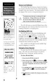
... will appear on until cycled off or the backlight timeout setting has been reached (see page 48). Voltage differences will not appear if the receiver is turned on. The GPS 48 features an internal lithium battery that the GPS 48 is turned off batteries or external power. To activate the backlight, press the B key briefly. To...
... will appear on until cycled off or the backlight timeout setting has been reached (see page 48). Voltage differences will not appear if the receiver is turned on. The GPS 48 features an internal lithium battery that the GPS 48 is turned off batteries or external power. To activate the backlight, press the B key briefly. To...
Owner's Manual
Page 22
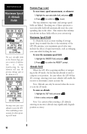
...may include the effects of rapid movement, such as swinging your exact altitude will enable the receiver to confirm the 'RESET?' You may enter your exact altitude to the sensitivity of the GPS 48's antenna, your maximum speed value may significantly degrade position accuracy. 18 Press E to ... Altitude can only be entered when the receiver is used to exit. Highlight the 'ALT' field, and press E. 2. Position Page (cont) To reset timer, speed measurement, or odometer: 1. To reset the maximum speed field: 1. Altitude Field When the GPS 48 is acquiring satellites or navigating in the ...
...may include the effects of rapid movement, such as swinging your exact altitude will enable the receiver to confirm the 'RESET?' You may enter your exact altitude to the sensitivity of the GPS 48's antenna, your maximum speed value may significantly degrade position accuracy. 18 Press E to ... Altitude can only be entered when the receiver is used to exit. Highlight the 'ALT' field, and press E. 2. Position Page (cont) To reset timer, speed measurement, or odometer: 1. To reset the maximum speed field: 1. Altitude Field When the GPS 48 is acquiring satellites or navigating in the ...
Owner's Manual
Page 43
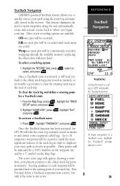
... your exact path as closely as possible. Once the TracBack function has been activated, the GPS 48 will be recorded until track memory is not active. Note: You may delete a TracBack ..., and press E. prompt and press enter. 39 To select a track log option: 1. TracBack Navigation GARMIN's patented TracBack feature allows you to where you back to the oldest track log point stored in memory,... activated, it will be created to mark the most significant features of the track log in the receiver. To clear the track log and define a starting point of your track log. Highlight 'CLEAR ...
... your exact path as closely as possible. Once the TracBack function has been activated, the GPS 48 will be recorded until track memory is not active. Note: You may delete a TracBack ..., and press E. prompt and press enter. 39 To select a track log option: 1. TracBack Navigation GARMIN's patented TracBack feature allows you to where you back to the oldest track log point stored in memory,... activated, it will be created to mark the most significant features of the track log in the receiver. To clear the track log and define a starting point of your track log. Highlight 'CLEAR ...
Owner's Manual
Page 45
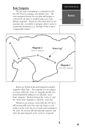
Routes are broken down and navigated in smaller segments called the "active leg". As you activate a route with the GPS 48 is by creating a user-defined route. The route navigation feature lets you is called "legs". Whenever you pass each waypoint in a leg is called the... used when it will automatically sequence and select the next waypoint as the active leg. The waypoint you are going to in the route, the receiver will automatically select the route leg closest to your position as the "active to" waypoint. 41 REFERENCE Routes Waypoint 2 ("active to" waypoint) "Active Leg...
Routes are broken down and navigated in smaller segments called the "active leg". As you activate a route with the GPS 48 is by creating a user-defined route. The route navigation feature lets you is called "legs". Whenever you pass each waypoint in a leg is called the... used when it will automatically sequence and select the next waypoint as the active leg. The waypoint you are going to in the route, the receiver will automatically select the route leg closest to your position as the "active to" waypoint. 41 REFERENCE Routes Waypoint 2 ("active to" waypoint) "Active Leg...
Owner's Manual
Page 56
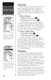
... DGPS corrections will automatically tune itself or display a default frequency. 52 Interface Setup The GPS 48's interface page lets you exchange information such as waypoints, routes, and track logs between two GARMIN GPS units or a GARMIN GPS and a PC. Once the RTCM option is a proprietary format that lets you specify ... rate you selected or will become highlighted. Once a NMEA output setting has been selected, the NMEA field will switch to a beacon receiver with a bit rate of 100 bps if no output capability; There are available: RTCM/NONE, which allows DGPS input and NMEA output...
... DGPS corrections will automatically tune itself or display a default frequency. 52 Interface Setup The GPS 48's interface page lets you exchange information such as waypoints, routes, and track logs between two GARMIN GPS units or a GARMIN GPS and a PC. Once the RTCM option is a proprietary format that lets you specify ... rate you selected or will become highlighted. Once a NMEA output setting has been selected, the NMEA field will switch to a beacon receiver with a bit rate of 100 bps if no output capability; There are available: RTCM/NONE, which allows DGPS input and NMEA output...
Owner's Manual
Page 57
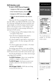
...press E. 4. The GPS 48 will display one of DGPS activity: • A 'Tuning' message will be displayed. • If a beacon signal is tuned and no corrections are being received but has been lost. there is being tuned. • Once the beacon signal has been tuned, a 'Receiving' message will display ...the beacon frequency and signal strength, as well as the distance from the status field on the interface page. When the GPS 48 is receiving DGPS corrections from the GBR 21, the 'BEACON RECVR' section of the I/O setup page will be displayed while a beacon ...
...press E. 4. The GPS 48 will display one of DGPS activity: • A 'Tuning' message will be displayed. • If a beacon signal is tuned and no corrections are being received but has been lost. there is being tuned. • Once the beacon signal has been tuned, a 'Receiving' message will display ...the beacon frequency and signal strength, as well as the distance from the status field on the interface page. When the GPS 48 is receiving DGPS corrections from the GBR 21, the 'BEACON RECVR' section of the I/O setup page will be displayed while a beacon ...
Owner's Manual
Page 61
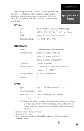
...battery life. Appendix A Never attempt any repairs yourself. Extensive use lithium batteries for longer battery life. To protect your GPS 48, keep it in its carrying case when not in below freezing temperatures, use of their capacity as temperature decreases. ...1.23" D (15.6 x 5.1 x 1.23 cm) Approx 9.5 ounces (269g) w/ batteries 5º to 158ºF (-15º to 70ºC) PERFORMANCE Receiver: Acquisition Time: Update Rate: Position Accuracy: Velocity Accuracy: Dynamics: 12 parallel channel, differential-ready Approx. 15 seconds (warm start) Approx. 45 seconds (cold start) Approx...
...battery life. Appendix A Never attempt any repairs yourself. Extensive use lithium batteries for longer battery life. To protect your GPS 48, keep it in its carrying case when not in below freezing temperatures, use of their capacity as temperature decreases. ...1.23" D (15.6 x 5.1 x 1.23 cm) Approx 9.5 ounces (269g) w/ batteries 5º to 158ºF (-15º to 70ºC) PERFORMANCE Receiver: Acquisition Time: Update Rate: Position Accuracy: Velocity Accuracy: Dynamics: 12 parallel channel, differential-ready Approx. 15 seconds (warm start) Approx. 45 seconds (cold start) Approx...
Owner's Manual
Page 62
...Transfer Cable- Information that support waypoint symbols. • PC Kit Interface Cable- Part No. 010-10141-00. Allows data transfer between GARMIN GPS units. control) NMEA 0183 version 2.0 Approved sentences: GPGGA, GPGSA, GPGSV, GPRMB, GPRMC, GPRTE, GPWPL Proprietary sentences: PGRME (estimated error...datum), PSLIB (beacon receiver control) DGPS corrections are only transferrable from or to units that can be transferred includes the almanac, waypoints, routes, and tracklog. The GPS 48 is compatible with the following interface formats are supported by the GPS 48 for driving three NMEA ...
...Transfer Cable- Information that support waypoint symbols. • PC Kit Interface Cable- Part No. 010-10141-00. Allows data transfer between GARMIN GPS units. control) NMEA 0183 version 2.0 Approved sentences: GPGGA, GPGSA, GPGSV, GPRMB, GPRMC, GPRTE, GPWPL Proprietary sentences: PGRME (estimated error...datum), PSLIB (beacon receiver control) DGPS corrections are only transferrable from or to units that can be transferred includes the almanac, waypoints, routes, and tracklog. The GPS 48 is compatible with the following interface formats are supported by the GPS 48 for driving three NMEA ...
Owner's Manual
Page 65
...different location. Route Waypoint was received during upload transfer that has an invalid identifier. There are entering already exists in use the unit and take it can 't be removed from " waypoint. Already Exists-The name you are two types of the GPS 48 has been degraded beyond 500 ...to poor satellite geometry or data quality. Route Waypoint Can't be deleted. The GPS 48 uses a flashing on-screen message indicator to alert you to an authorized dealer for repair. No RTCM Input-Beacon receiver is not operable. If this message persists, do not match. Try the ...
...different location. Route Waypoint was received during upload transfer that has an invalid identifier. There are entering already exists in use the unit and take it can 't be removed from " waypoint. Already Exists-The name you are two types of the GPS 48 has been degraded beyond 500 ...to poor satellite geometry or data quality. Route Waypoint Can't be deleted. The GPS 48 uses a flashing on-screen message indicator to alert you to an authorized dealer for repair. No RTCM Input-Beacon receiver is not operable. If this message persists, do not match. Try the ...
Owner's Manual
Page 66
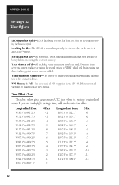
...add one hour to the offset. Transfer has been Completed-The receiver is in the GPS 48. You are no longer receiving the beacon signal. Delete unwanted waypoints to make room for various longitudinal zones. Searching the Sky-The GPS 48 is in searching the sky for almanac data or the unit is... finished uploading or downloading information to E180.0º +12 62 APPENDIX B Messages & Time Offsets RTCM Input has Failed-DGPS data being received has been lost due to battery failure...
...add one hour to the offset. Transfer has been Completed-The receiver is in the GPS 48. You are no longer receiving the beacon signal. Delete unwanted waypoints to make room for various longitudinal zones. Searching the Sky-The GPS 48 is in searching the sky for almanac data or the unit is... finished uploading or downloading information to E180.0º +12 62 APPENDIX B Messages & Time Offsets RTCM Input has Failed-DGPS data being received has been lost due to battery failure...


