
GPS 12, 12XL, 48, 80 Addendum
Page 1
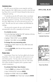
... the unit that you need to conserve battery power. To activate the Power Save feature: 1. Using the ROCKER select 'Power Save' and press ENTER. Before using the track log. This will falsify the readings. To calculate an area: 1. Highlight 'CALC AREA' and press ENTER. Highlight the 'UNITS' field in a track log. The unit used to display the SETUP MENU. 2. Please refer to subtract and will cause the unit to your GPS Owner's Manual for directions...
... the unit that you need to conserve battery power. To activate the Power Save feature: 1. Using the ROCKER select 'Power Save' and press ENTER. Before using the track log. This will falsify the readings. To calculate an area: 1. Highlight 'CALC AREA' and press ENTER. Highlight the 'UNITS' field in a track log. The unit used to display the SETUP MENU. 2. Please refer to subtract and will cause the unit to your GPS Owner's Manual for directions...

Owner's Manual
Page 3
... navigational terms. Getting Started introduces you are missing any parts, please contact your GARMIN GPS 48 package includes the following items. If you to the basic features of the unit and provides a quick-start orientation to understand the operating features of the GPS 48 by topic. This manual is organized into four sections for accessories including our PC kit, swivel mounts, external antennas, and power/data cables...
... navigational terms. Getting Started introduces you are missing any parts, please contact your GARMIN GPS 48 package includes the following items. If you to the basic features of the unit and provides a quick-start orientation to understand the operating features of the GPS 48 by topic. This manual is organized into four sections for accessories including our PC kit, swivel mounts, external antennas, and power/data cables...
Owner's Manual
Page 4
... remedies do not correct the problem. Repairs should only be made by relocating the equipment or connecting the equipment to other qualified service technician for home or office use , carefully compare indications from other NAVAIDs, visual sightings, maps, etc. Use the GPS 48 at your authority to correct the interference by an authorized service center. For safety, always resolve any user-serviceable parts.
... remedies do not correct the problem. Repairs should only be made by relocating the equipment or connecting the equipment to other qualified service technician for home or office use , carefully compare indications from other NAVAIDs, visual sightings, maps, etc. Use the GPS 48 at your authority to correct the interference by an authorized service center. For safety, always resolve any user-serviceable parts.
Owner's Manual
Page 5
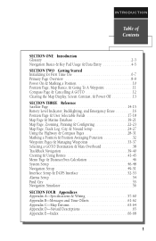
...-31 Marking a Position & Position Averaging Function 32 Waypoint Pages & Managing Waypoints 33-37 Selecting a GOTO Destination & Man Overboard 38 TrackBack Navigation 39-40 Creating & Using Routes 41-45 Menu Page & Distance/Sun Calculation 46 System Setup 46-48 Navigation Setup 49-51 Interface Setup & DGPS Interface 52-53 Alarms Setup 54 Find City 55 Navigation Simulator 56 SECTION FOUR Appendices Appendix A--Specifications & Wiring 57-60 Appendix B-Messages and Time Offsets 61-62...
...-31 Marking a Position & Position Averaging Function 32 Waypoint Pages & Managing Waypoints 33-37 Selecting a GOTO Destination & Man Overboard 38 TrackBack Navigation 39-40 Creating & Using Routes 41-45 Menu Page & Distance/Sun Calculation 46 System Setup 46-48 Navigation Setup 49-51 Interface Setup & DGPS Interface 52-53 Alarms Setup 54 Find City 55 Navigation Simulator 56 SECTION FOUR Appendices Appendix A--Specifications & Wiring 57-60 Appendix B-Messages and Time Offsets 61-62...
Owner's Manual
Page 6
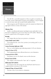
... present position. To better understand its operation and capabilities, it may be acquired before GPS navigation can guide you are defined in the world. Almanac data must be helpful to review the basic terms and concepts briefly explained below. INTRODUCTION Glossary The GPS 48 is transmitted to your receiver from " and "to" waypoints. Estimated Time of Arrival (ETA) The time of day of the manual.
... present position. To better understand its operation and capabilities, it may be acquired before GPS navigation can guide you are defined in the world. Almanac data must be helpful to review the basic terms and concepts briefly explained below. INTRODUCTION Glossary The GPS 48 is transmitted to your receiver from " and "to" waypoints. Estimated Time of Arrival (ETA) The time of day of the manual.
Owner's Manual
Page 8
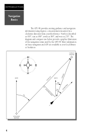
"ACTIVE TO" WAYPOINT DISTANCE "ACTIVE LEG" GROUND SPEED NORTH DTK "ACTIVE FROM" WAYPOINT 4 CROSSTRACK ERROR NORTH BRG TRK INTRODUCTION Navigation Basics The GPS 48 provides steering guidance and navigation information using degrees, a measurement measured in a clockwise direction from a north reference. North is described as 000º, east as 090º, south as 180º, and west as 270º. The diagram and compass rose below provide...
"ACTIVE TO" WAYPOINT DISTANCE "ACTIVE LEG" GROUND SPEED NORTH DTK "ACTIVE FROM" WAYPOINT 4 CROSSTRACK ERROR NORTH BRG TRK INTRODUCTION Navigation Basics The GPS 48 provides steering guidance and navigation information using degrees, a measurement measured in a clockwise direction from a north reference. North is described as 000º, east as 090º, south as 180º, and west as 270º. The diagram and compass rose below provide...
Owner's Manual
Page 13
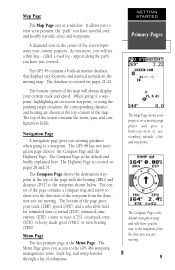
... the direction you to the GPS 48's waypoint management, route, track log, and setup features through a list of the map will see a thin line - GETTING STARTED Primary Pages The Map Page shows your track (TRK), speed (SPD), and a selectable field for estimated time to arrival (ETA), estimated time enroute (ETE), course to a waypoint. The top of the screen represents your position, the "path" you are moving...
... the direction you to the GPS 48's waypoint management, route, track log, and setup features through a list of the map will see a thin line - GETTING STARTED Primary Pages The Map Page shows your track (TRK), speed (SPD), and a selectable field for estimated time to arrival (ETA), estimated time enroute (ETE), course to a waypoint. The top of the screen represents your position, the "path" you are moving...

Owner's Manual
Page 17
... backlighting, press the B key repeatatly until the Satellite Page appears. 2. Press and hold the B key for nighttime use. If you encounter any problems using the unit or want to finish. Clearing a Cluttered Map Display After you've used the GPS 48 for a few trips, you may find that your map display has become a bit messy from keeping track of your own navigation skills. Press P or Q until turned...
... backlighting, press the B key repeatatly until the Satellite Page appears. 2. Press and hold the B key for nighttime use. If you encounter any problems using the unit or want to finish. Clearing a Cluttered Map Display After you've used the GPS 48 for a few trips, you may find that your map display has become a bit messy from keeping track of your own navigation skills. Press P or Q until turned...
Owner's Manual
Page 18
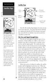
... position. REFERENCE Satellite Page Satellite Page Status Field Battery Indicator Estimated Position Error Skyview Display Signal Strength Indicators The GPS 48 Satellite Page will help you determine which satellites are in the sky view. The satellite sky view shows a bird's-eye-view of the position of what the GPS 48 is looking for navigation the strength indicator bar will tell you whether or not the receiver has calculated a position fix. You can use the sky view to a track...
... position. REFERENCE Satellite Page Satellite Page Status Field Battery Indicator Estimated Position Error Skyview Display Signal Strength Indicators The GPS 48 Satellite Page will help you determine which satellites are in the sky view. The satellite sky view shows a bird's-eye-view of the position of what the GPS 48 is looking for navigation the strength indicator bar will tell you whether or not the receiver has calculated a position fix. You can use the sky view to a track...
Owner's Manual
Page 20
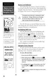
... holding down the Mkey, hold down the B key to determine if backlighting is turned on during daylight hours. Ni-Cad and lithium batteries differently. To increase the brightness, repeatedly press the B key. tor, located to the left of the sky view, which displays the strength of brightness. Backlighting Bulb Icon The GPS 48 features full-screen backlighting with "Yes?" The backlight will be deleted, including: routes, waypoints, and the track...
... holding down the Mkey, hold down the B key to determine if backlighting is turned on during daylight hours. Ni-Cad and lithium batteries differently. To increase the brightness, repeatedly press the B key. tor, located to the left of the sky view, which displays the strength of brightness. Backlighting Bulb Icon The GPS 48 features full-screen backlighting with "Yes?" The backlight will be deleted, including: routes, waypoints, and the track...
Owner's Manual
Page 22
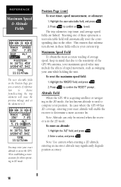
... the GPS 48 in establishing a more accurate fix. To enter an altitude: 1. Altitude Field When the GPS 48 is acquiring satellites or navigating in the 2D mode, the last known altitude is in the 2D mode. Press E to confirm the 'RESET?' Highlight the 'ALT' field, and press E. 2. This ensures that due to the sensitivity of the GPS 48's antenna, your arm while holding the unit. To reset the maximum speed field: 1. Note: Use caution when entering a 2D altitude, entering...
... the GPS 48 in establishing a more accurate fix. To enter an altitude: 1. Altitude Field When the GPS 48 is acquiring satellites or navigating in the 2D mode, the last known altitude is in the 2D mode. Press E to confirm the 'RESET?' Highlight the 'ALT' field, and press E. 2. This ensures that due to the sensitivity of the GPS 48's antenna, your arm while holding the unit. To reset the maximum speed field: 1. Note: Use caution when entering a 2D altitude, entering...
Owner's Manual
Page 29
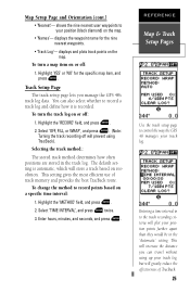
To turn the track log on a specific time interval: 1. To change the method to control the way the GPS 48 manages your track log, but will greatly reduce the effectiveness of track memory and provides the best TracBack route. REFERENCE Map & Track Setup Pages Use the track setup page to record points based on or off: 1. displays the waypoint name for the specific map item, and press E. Track Setup Page The track setup page lets you can...
To turn the track log on a specific time interval: 1. To change the method to control the way the GPS 48 manages your track log, but will greatly reduce the effectiveness of track memory and provides the best TracBack route. REFERENCE Map & Track Setup Pages Use the track setup page to record points based on or off: 1. displays the waypoint name for the specific map item, and press E. Track Setup Page The track setup page lets you can...
Owner's Manual
Page 37
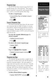
nearest waypoints, waypoint list, and waypoint definition-can retrieve a waypoint definition page, delete all user-defined waypoints, delete waypoints by symbol, or review and perform a GOTO to a selected waypoint. To delete all waypoints currently stored in the GPS 48 and their respective waypoint symbols. Highlight 'DELETE WPTS?', and press E. REFERENCE Waypoint Pages To select a waypoint submenu, highlight the desired option and press ENTER. These pages- To select a waypoint page: 1. Waypoint List Page The waypoint list...
nearest waypoints, waypoint list, and waypoint definition-can retrieve a waypoint definition page, delete all user-defined waypoints, delete waypoints by symbol, or review and perform a GOTO to a selected waypoint. To delete all waypoints currently stored in the GPS 48 and their respective waypoint symbols. Highlight 'DELETE WPTS?', and press E. REFERENCE Waypoint Pages To select a waypoint submenu, highlight the desired option and press ENTER. These pages- To select a waypoint page: 1. Waypoint List Page The waypoint list...
Owner's Manual
Page 39
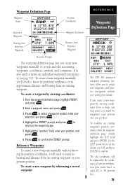
... coordinates will be replaced by referencing a stored waypoint: REFERENCE Waypoint Definition Page The GPS 48's advanced waypoint planning features allow you to know its position coordinates or its bearing and distance from an existing waypoint. To create a waypoint by entering coordinates from the waypoint definition page, simply highlight the DST field and press ENTER. Highlight the 'DONE?' If you 'll need to create new waypoints and practice navigation without knowing its position coordinates...
... coordinates will be replaced by referencing a stored waypoint: REFERENCE Waypoint Definition Page The GPS 48's advanced waypoint planning features allow you to know its position coordinates or its bearing and distance from an existing waypoint. To create a waypoint by entering coordinates from the waypoint definition page, simply highlight the DST field and press ENTER. Highlight the 'DONE?' If you 'll need to create new waypoints and practice navigation without knowing its position coordinates...
Owner's Manual
Page 44
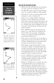
... waypoints in memory to create a TracBack route, you will be alerted with a 'waypoint memory full' message, and the receiver will use any available waypoints to create a TracBack route with an emphasis on the track log closest to the destination (the oldest track log point in memory). • If the 'METHOD' option on the track log setup page is turned off or you to navigate your track...
... waypoints in memory to create a TracBack route, you will be alerted with a 'waypoint memory full' message, and the receiver will use any available waypoints to create a TracBack route with an emphasis on the track log closest to the destination (the oldest track log point in memory). • If the 'METHOD' option on the track log setup page is turned off or you to navigate your track...
Owner's Manual
Page 49
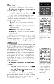
... to the desired track of editing choices will not affect route 0. Note that the GPS 48 will be the route leg closest to your position as the active leg. This may mean you're not navigating to the first waypoint in sequence using the page you reach the on -screen menu of the active leg. point highlighted, press E. deletes a selected waypoint. • Change?- On-Route GOTOs At...
... to the desired track of editing choices will not affect route 0. Note that the GPS 48 will be the route leg closest to your position as the active leg. This may mean you're not navigating to the first waypoint in sequence using the page you reach the on -screen menu of the active leg. point highlighted, press E. deletes a selected waypoint. • Change?- On-Route GOTOs At...
Owner's Manual
Page 51
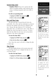
... set to change the plus or minus sign. Highlight the 'MODE' field, and press E. 2. Enter the time offset, and press E. Highlight the 'HOURS' field, and press E. 2. System Setup (cont) • Simulator Mode allows you to operate the unit without acquiring satellites, and is ideal for practicing or entering waypoints and routes while at the end of Appendix B. 47 To enter the time offset: 1. Time Format The time display shown on the system setup and Position...
... set to change the plus or minus sign. Highlight the 'MODE' field, and press E. 2. Enter the time offset, and press E. Highlight the 'HOURS' field, and press E. 2. System Setup (cont) • Simulator Mode allows you to operate the unit without acquiring satellites, and is ideal for practicing or entering waypoints and routes while at the end of Appendix B. 47 To enter the time offset: 1. Time Format The time display shown on the system setup and Position...
Owner's Manual
Page 56
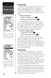
... Interface Setup The GPS 48's interface page lets you specify the formats for connecting external devices. Once a RTCM setting has been selected, the GPS 48 will either automatically try to a beacon receiver with a bit rate of 100 bps if no output capability; To select I /O field, and press E. 2. You may also enter your own frequency and bit rate if desired. The GRMN/GRMN setting is selected the GPS 48 will switch to transfer information...
... Interface Setup The GPS 48's interface page lets you specify the formats for connecting external devices. Once a RTCM setting has been selected, the GPS 48 will either automatically try to a beacon receiver with a bit rate of 100 bps if no output capability; To select I /O field, and press E. 2. You may also enter your own frequency and bit rate if desired. The GRMN/GRMN setting is selected the GPS 48 will switch to transfer information...
Owner's Manual
Page 65
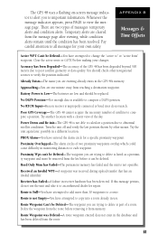
... enough data is not Empty-You have attempted to add more than 30 waypoints to compute a position. Received an Invalid WPT-A waypoint was Deleted-A route waypoint entered does not exist in monitoring distances to delete is not operable. APPENDIX B Messages & Time Offsets Active WPT Can't be Deleted-The waypoint you are trying to each waypoint. The GPS 48 uses a flashing on-screen message indicator to alert you to compute a DGPS position. Poor GPS Coverage-The GPS 48 cannot acquire...
... enough data is not Empty-You have attempted to add more than 30 waypoints to compute a position. Received an Invalid WPT-A waypoint was Deleted-A route waypoint entered does not exist in monitoring distances to delete is not operable. APPENDIX B Messages & Time Offsets Active WPT Can't be Deleted-The waypoint you are trying to each waypoint. The GPS 48 uses a flashing on-screen message indicator to alert you to compute a DGPS position. Poor GPS Coverage-The GPS 48 cannot acquire...

Owner's Manual
Page 72
... Scanning Waypoints . . . . .37 Screen Backlighting . .13, 48 Screen Contrast . . . . .13, 48 Signal Strength Bars . . . . .14 Simulator 55 Sky View 14 Specifications 56 Speed Filter 51 System Setup 46 T Time Format 47 Time Offset 59 Tone Setting 48 TracBack Navigation . . . . .39 TracBack Tips 40 Track Log Display . . .25, 40 Track Method 40 Track Setup 25 Trip Timer (TTIME) . . . . .17 Troubleshooting 7 Turn (TRN 17 Trip odometer 17 U Units of Measure 50 User-defined route . . . . . .42 User Grid 49 Using the Keypad 5 Using the Position...
... Scanning Waypoints . . . . .37 Screen Backlighting . .13, 48 Screen Contrast . . . . .13, 48 Signal Strength Bars . . . . .14 Simulator 55 Sky View 14 Specifications 56 Speed Filter 51 System Setup 46 T Time Format 47 Time Offset 59 Tone Setting 48 TracBack Navigation . . . . .39 TracBack Tips 40 Track Log Display . . .25, 40 Track Method 40 Track Setup 25 Trip Timer (TTIME) . . . . .17 Troubleshooting 7 Turn (TRN 17 Trip odometer 17 U Units of Measure 50 User-defined route . . . . . .42 User Grid 49 Using the Keypad 5 Using the Position...


