
End User License Agreement
Page 2
...consult your best judgment and exercise common sense when making navigational decisions. Operational and Navigation Warnings • Do not input destinations, change settings, or access any functions requiring prolonged use the Garmin accessory approved for the consequences of the device/battery in...not disassemble, puncture, or damage the battery. • If using a heart rate monitor. Warning Failure to all available navigation sources, including road signs, road closures, • When storing the device for attentiveness, good judgement, and proper preparation. Ensure that ...
...consult your best judgment and exercise common sense when making navigational decisions. Operational and Navigation Warnings • Do not input destinations, change settings, or access any functions requiring prolonged use the Garmin accessory approved for the consequences of the device/battery in...not disassemble, puncture, or damage the battery. • If using a heart rate monitor. Warning Failure to all available navigation sources, including road signs, road closures, • When storing the device for attentiveness, good judgement, and proper preparation. Ensure that ...

Owner's Manual
Page 3
... Location 3 Creating a Course from History 3 Riding a Saved Course 3 Editing the Course Settings 3 Stopping Navigation 3 ANT +™ Sensors 3 Pairing a Heart Rate Monitor 3 Pairing an eBike 4 History 4 Viewing...Device 4 Deleting Files 4 Disconnecting the USB Cable 4 Sending Your Ride to Garmin Connect 4 Garmin Connect 5 Customizing Your Device 5 Routing Options 5 Customizing the Trip Pages 5... the Device Tones 6 Restoring the Factory Settings 6 Time Zones 6 Device Information 6 Edge Specifications 6 About IPX7 6 Device Care 6 Cleaning the Device 6 Viewing Satellites 6 ...
... Location 3 Creating a Course from History 3 Riding a Saved Course 3 Editing the Course Settings 3 Stopping Navigation 3 ANT +™ Sensors 3 Pairing a Heart Rate Monitor 3 Pairing an eBike 4 History 4 Viewing...Device 4 Deleting Files 4 Disconnecting the USB Cable 4 Sending Your Ride to Garmin Connect 4 Garmin Connect 5 Customizing Your Device 5 Routing Options 5 Customizing the Trip Pages 5... the Device Tones 6 Restoring the Factory Settings 6 Time Zones 6 Device Information 6 Edge Specifications 6 About IPX7 6 Device Care 6 Cleaning the Device 6 Viewing Satellites 6 ...

Owner's Manual
Page 6
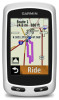
... Same Route. • To return by name. • Select to acquire satellite signals. TIP: You can record and store locations in the device. 2 Navigation It may need a clear view of the sky to delete an item. NOTE: If the device cannot acquire satellite signals to determine your current location...take 30-60 seconds to stop the timer. 6 Select Save. Home Screen Overview The home screen gives you have selected all the features of the Edge. TIP: You can record details of your route, and a map of the device should be oriented toward the sky. 2 Wait while the ...
... Same Route. • To return by name. • Select to acquire satellite signals. TIP: You can record and store locations in the device. 2 Navigation It may need a clear view of the sky to delete an item. NOTE: If the device cannot acquire satellite signals to determine your current location...take 30-60 seconds to stop the timer. 6 Select Save. Home Screen Overview The home screen gives you have selected all the features of the Edge. TIP: You can record details of your route, and a map of the device should be oriented toward the sky. 2 Wait while the ...
Owner's Manual
Page 7
...Saved > Locations. 2 Select a location. 3 Select the location information at the top of interest. 4 Select RIDE. ANT +™ Sensors The Edge Touring Plus can search for specific types of locations. 1 From the home screen, select Where To? > Search Tools > POI Categories. 2 Select a ... Settings. 4 Select an option: • To change the name of the screen. 4 Select > Delete Location > . Creating a Course from History You can navigate to a saved photo, you must transfer a geotagged photo to your device (page 4). 1 From the home screen, select Where To? > Saved > Photos. ...
...Saved > Locations. 2 Select a location. 3 Select the location information at the top of interest. 4 Select RIDE. ANT +™ Sensors The Edge Touring Plus can search for specific types of locations. 1 From the home screen, select Where To? > Search Tools > POI Categories. 2 Select a ... Settings. 4 Select an option: • To change the name of the screen. 4 Select > Delete Location > . Creating a Course from History You can navigate to a saved photo, you must transfer a geotagged photo to your device (page 4). 1 From the home screen, select Where To? > Saved > Photos. ...

Owner's Manual
Page 9
..., which represents your favorite social networking sites. Compass: Enables or disables the compass page. Elevation Settings NOTE: The Edge Touring shows elevation information only when the device is selected, you deviate from the route. Avoidance Setup: Sets the road ...Go to avoid while navigating. Garmin Connect Garmin Connect gives you want. Map Detail: Sets the level of travel at any location during the ride where you select . • Select Mark and Lap to show your activities on -screen instructions. The Edge Touring Plus displays elevation information...
..., which represents your favorite social networking sites. Compass: Enables or disables the compass page. Elevation Settings NOTE: The Edge Touring shows elevation information only when the device is selected, you deviate from the route. Avoidance Setup: Sets the road ...Go to avoid while navigating. Garmin Connect Garmin Connect gives you want. Map Detail: Sets the level of travel at any location during the ride where you select . • Select Mark and Lap to show your activities on -screen instructions. The Edge Touring Plus displays elevation information...

Owner's Manual
Page 11
... the next point on the route (adjusted to the local time of day you travel . You must be navigating for this data to appear. You must be navigating for information about optional accessories and replacement parts. ETA at Next: The estimated time of the waypoint). For ...example, your GPS location is 35 minutes. For example, if for the current activity. Your device must be connected to http: / / buy .garmin .com, or contact your Garmin ...
... the next point on the route (adjusted to the local time of day you travel . You must be navigating for this data to appear. You must be navigating for information about optional accessories and replacement parts. ETA at Next: The estimated time of the waypoint). For ...example, your GPS location is 35 minutes. For example, if for the current activity. Your device must be connected to http: / / buy .garmin .com, or contact your Garmin ...

Owner's Manual
Page 12
You must be navigating for this data to appear. You must be navigating for this data to appear. Total Descent: The total elevation distance descended since the last reset. Time to Dest. : The estimated time remaining before you reach the destination. Total Ascent: The total elevation distance ascended since the last reset. 8 Appendix Time of Day: The current time of day based on your current location and time settings (format, time zone, daylight saving time). Time to Next: The estimated time remaining before you reach the next waypoint in the route.
You must be navigating for this data to appear. You must be navigating for this data to appear. Total Descent: The total elevation distance descended since the last reset. Time to Dest. : The estimated time remaining before you reach the destination. Total Ascent: The total elevation distance ascended since the last reset. 8 Appendix Time of Day: The current time of day based on your current location and time settings (format, time zone, daylight saving time). Time to Next: The estimated time remaining before you reach the next waypoint in the route.
Owner's Manual
Page 13
...7 maximizing 7 type 1 brightness 7 C charging 7 charging the device 1 cleaning the device 6 compass, settings 5 computer, connecting 4 courses creating 3 navigating 3 settings 3 customizing the device 5 D data storing 5 transferring 4, 5 data fields 5, 7 data recording 6 deleting all user data 4, 7 history ...care 6 registration 7 resetting 6 display settings 5 E eBike 4 elevation, settings 5 F files, transferring 4 finding locations, near your location 3 G Garmin Connect 4 storing data 5 GPS satellite page 6 signal 2 H heart rate monitor, pairing 3 history 2, 4 deleting 4 sending to computer 4, ...
...7 maximizing 7 type 1 brightness 7 C charging 7 charging the device 1 cleaning the device 6 compass, settings 5 computer, connecting 4 courses creating 3 navigating 3 settings 3 customizing the device 5 D data storing 5 transferring 4, 5 data fields 5, 7 data recording 6 deleting all user data 4, 7 history ...care 6 registration 7 resetting 6 display settings 5 E eBike 4 elevation, settings 5 F files, transferring 4 finding locations, near your location 3 G Garmin Connect 4 storing data 5 GPS satellite page 6 signal 2 H heart rate monitor, pairing 3 history 2, 4 deleting 4 sending to computer 4, ...


