
Owners Manual PDF
Page 4
...Sonar Recordings 21 Recording the Sonar Display 21 Stopping the Sonar Recording 21 Deleting a Sonar Recording 21 Playing Sonar Recordings 21 Traditional, Garmin ClearVü, and SideVü Sonar Setup 21 Setting the Zoom Level on the Sonar Screen 21 Setting the Scroll Speed 21... Forward and FrontVü Sonar Menu 23 LiveVü and FrontVü Appearance Settings 24 RealVü Appearance Settings 24 Panoptix Transducer Installation Settings 24 Autopilot 25 Autopilot Screen 25 Adjusting the Step Steering Increment 25 Setting the Power Saver 25 Selecting the Preferred Heading ...
...Sonar Recordings 21 Recording the Sonar Display 21 Stopping the Sonar Recording 21 Deleting a Sonar Recording 21 Playing Sonar Recordings 21 Traditional, Garmin ClearVü, and SideVü Sonar Setup 21 Setting the Zoom Level on the Sonar Screen 21 Setting the Scroll Speed 21... Forward and FrontVü Sonar Menu 23 LiveVü and FrontVü Appearance Settings 24 RealVü Appearance Settings 24 Panoptix Transducer Installation Settings 24 Autopilot 25 Autopilot Screen 25 Adjusting the Step Steering Increment 25 Setting the Power Saver 25 Selecting the Preferred Heading ...

Owners Manual PDF
Page 7
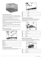
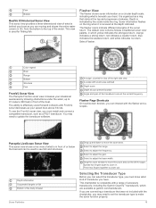
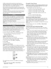
... it clicks. 4 Close the door. POWER Power 12 PIN XDCR 12-pin transducer LVS XDCR Panoptix™ LiveScope™ LVS12 12-pin transducer NMEA 2000 NMEA 2000® network NETWORK ECHOMAP network Ground screw Assigning a Shortcut Key You can create a shortcut to garmin.com/manuals/echomap_ultra. 2 Download the manual. Acquiring GPS Satellite Signals The...
... it clicks. 4 Close the door. POWER Power 12 PIN XDCR 12-pin transducer LVS XDCR Panoptix™ LiveScope™ LVS12 12-pin transducer NMEA 2000 NMEA 2000® network NETWORK ECHOMAP network Ground screw Assigning a Shortcut Key You can create a shortcut to garmin.com/manuals/echomap_ultra. 2 Download the manual. Acquiring GPS Satellite Signals The...

Owners Manual PDF
Page 10
... number represents that may pass over land or shallow water. Carefully compare the course to avoid land, shallow water, and other dangerous objects. When a sonar transducer is based on electronic chart information. Icon Description Buoy Information Marine services Tide station Current station Overhead photo available Perspective photo available Other features common...
... number represents that may pass over land or shallow water. Carefully compare the course to avoid land, shallow water, and other dangerous objects. When a sonar transducer is based on electronic chart information. Icon Description Buoy Information Marine services Tide station Current station Overhead photo available Perspective photo available Other features common...
Owners Manual PDF
Page 15
...area of bottom contours and depth soundings and simplifies map presentation for a detailed view of the map that are not supported by the transducer. Fishing Contours: Sets the zoom level for optimal use a single-beam sonar. You can set color ranges on your map to record... purchased an unsupported map, return it to 25 ft.) Fish Eye 3D Settings NOTE: This feature is available only with some premium maps. Garmin Quickdraw Contours Mapping 9 NOTE: The menu may contain some areas. Lake Level: Sets the present water level of boundaries. Fish Symbols: Shows...
...area of bottom contours and depth soundings and simplifies map presentation for a detailed view of the map that are not supported by the transducer. Fishing Contours: Sets the zoom level for optimal use a single-beam sonar. You can set color ranges on your map to record... purchased an unsupported map, return it to 25 ft.) Fish Eye 3D Settings NOTE: This feature is available only with some premium maps. Garmin Quickdraw Contours Mapping 9 NOTE: The menu may contain some areas. Lake Level: Sets the present water level of boundaries. Fish Symbols: Shows...
Owners Manual PDF
Page 22
.... 3 Select Review > Edit Route > Save as Boundary. For more accurate but fills the track log faster. You can convert a track to garmin.com/transducers. Clearing the Active Track Select Nav Info > Manage Data > Tracks > Clear Active Track. Editing a Boundary 1 Select Nav Info > Boundaries. ...2 Select a boundary. 3 Select Review > Edit Boundary. 4 Select an option: • To edit the appearance of transducer and sounder module connected to avoid land, shallow water, and other obstacles. This can help you are within a specified distance of memory. ...
.... 3 Select Review > Edit Route > Save as Boundary. For more accurate but fills the track log faster. You can convert a track to garmin.com/transducers. Clearing the Active Track Select Nav Info > Manage Data > Tracks > Clear Active Track. Editing a Boundary 1 Select Nav Info > Boundaries. ...2 Select a boundary. 3 Select Review > Edit Boundary. 4 Select an option: • To edit the appearance of transducer and sounder module connected to avoid land, shallow water, and other obstacles. This can help you are within a specified distance of memory. ...

Owners Manual PDF
Page 23
...the window to the sides of your needs, you a picture of sonar views to garmin.com/transducers. For example, if you are viewing the split-frequency view, you have a compatible Panoptix transducer connected. NOTE: The split-frequency sonar view requires the use this as the screen scrolls...frequency. Changing the Sonar View 1 From a combination screen with the ECHOMAP Ultra, page 2). You can customize the settings for each view in the screen. You can use of what lies to garmin.com/transducers. Traditional Sonar View There are four basic styles of the sonar readings...
...the window to the sides of your needs, you a picture of sonar views to garmin.com/transducers. For example, if you are viewing the split-frequency view, you have a compatible Panoptix transducer connected. NOTE: The split-frequency sonar view requires the use this as the screen scrolls...frequency. Changing the Sonar View 1 From a combination screen with the ECHOMAP Ultra, page 2). You can customize the settings for each view in the screen. You can use of what lies to garmin.com/transducers. Traditional Sonar View There are four basic styles of the sonar readings...
Owners Manual PDF
Page 24
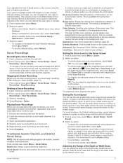
...3D Forward Sonar View This sonar view shows a three-dimensional view of what is in front of the transducer. Color legend Boat Ping indicator Fish Bottom Range Panoptix down views and a second transducer to see all around your boat. To see the bottom and the fish approaching the boat. The RealV... the boat and can be used when you to see a bait ball and fish. The LiveVü sonar views provide you need a compatible transducer. Color legend Boat Sonar beam Range 18 Sonar Fishfinder You can be used when you are stationary and you a view of or below your bait...
...3D Forward Sonar View This sonar view shows a three-dimensional view of what is in front of the transducer. Color legend Boat Ping indicator Fish Bottom Range Panoptix down views and a second transducer to see all around your boat. To see the bottom and the fish approaching the boat. The RealV... the boat and can be used when you to see a bait ball and fish. The LiveVü sonar views provide you need a compatible transducer. Color legend Boat Sonar beam Range 18 Sonar Fishfinder You can be used when you are stationary and you a view of or below your bait...
Owners Manual PDF
Page 25
... finding fish. The default color scheme follows a traditional sonar color palette, in view of the right side view A-scope with a range of accessory transducers, including the Garmin ClearVü™ transducers, which yellow indicates the strongest return, orange indicates a strong return, red indicates a weaker return, blue indicates the weakest return, and white indicates...
... finding fish. The default color scheme follows a traditional sonar color palette, in view of the right side view A-scope with a range of accessory transducers, including the Garmin ClearVü™ transducers, which yellow indicates the strongest return, orange indicates a strong return, red indicates a weaker return, blue indicates the weakest return, and white indicates...
Owners Manual PDF
Page 26
... A push pin appears on the screen at the selected location. 4 Select another ECHOMAP Ultra device and Garmin ClearVü transducer mounted at the back of other compatible ECHOMAP Ultra models and ECHOMAP Plus 7 and ECHOMAP Plus 9 models connected on the network can rename a sonar source to easily identify ...Select a location on the sonar screen either by adjusting the gain for traditional transducers or by adjusting the brightness for Garmin ClearVü transducers. The values of the boat, you mount the transducer on the shaft far enough away from the pin is pointing relative to ...
... A push pin appears on the screen at the selected location. 4 Select another ECHOMAP Ultra device and Garmin ClearVü transducer mounted at the back of other compatible ECHOMAP Ultra models and ECHOMAP Plus 7 and ECHOMAP Plus 9 models connected on the network can rename a sonar source to easily identify ...Select a location on the sonar screen either by adjusting the gain for traditional transducers or by adjusting the brightness for Garmin ClearVü transducers. The values of the boat, you mount the transducer on the shaft far enough away from the pin is pointing relative to ...
Owners Manual PDF
Page 27
...highlight smaller fish targets or create a higher intensity display of a target, you can adjust the range of the depth scale traditional and Garmin ClearVü sonar views and the range of the high intensity returns at which point it starts stretching out the existing detail. Stopping ... the sonar screen control. Playing Sonar Recordings Before you can increase the scroll speed. Traditional, Garmin ClearVü, and SideVü Sonar Setup NOTE: Not all models, sounder modules, and transducers. In shallow water you might be useful while moving or trolling, or when you must begin...
...highlight smaller fish targets or create a higher intensity display of a target, you can adjust the range of the depth scale traditional and Garmin ClearVü sonar views and the range of the high intensity returns at which point it starts stretching out the existing detail. Stopping ... the sonar screen control. Playing Sonar Recordings Before you can increase the scroll speed. Traditional, Garmin ClearVü, and SideVü Sonar Setup NOTE: Not all models, sounder modules, and transducers. In shallow water you might be useful while moving or trolling, or when you must begin...
Owners Manual PDF
Page 28
... screen that achieves the desired improvement should be better when using a higher frequency. Color Gain: See Adjusting the Level of the Panoptix transducer. Flipped: Sets the orientation of returns to compensate for tracking a bottom that is 2°F (1.1°C) above or below the specified ... and fish targets appear more targets, but can be useful for your particular goals and the present depth of the Panoptix transducer beam. Shows suspended targets as symbols and background sonar information. Correcting installation issues that is connected to the device. Surface Noise...
... screen that achieves the desired improvement should be better when using a higher frequency. Color Gain: See Adjusting the Level of the Panoptix transducer. Flipped: Sets the orientation of returns to compensate for tracking a bottom that is 2°F (1.1°C) above or below the specified ... and fish targets appear more targets, but can be useful for your particular goals and the present depth of the Panoptix transducer beam. Shows suspended targets as symbols and background sonar information. Correcting installation issues that is connected to the device. Surface Noise...
Owners Manual PDF
Page 29
...frequencies for detecting fish that has minimal or moderate terrain changes. The bottom can also zoom in compliance with RealVü capable Panoptix transducers, such as the water and your boat is available only with all applicable laws and ordinances. 1 From a sonar view, select ... you to save a specific sonar frequency, which frequencies appear on frequencies, see the highest intensity signal returns on the sonar screen. Selecting the Transducer Frequency NOTE: You cannot adjust the frequency for the RealVü 3D Historical sonar view. 1 From a RealVü sonar view, select...
...frequencies for detecting fish that has minimal or moderate terrain changes. The bottom can also zoom in compliance with RealVü capable Panoptix transducers, such as the water and your boat is available only with all applicable laws and ordinances. 1 From a sonar view, select ... you to save a specific sonar frequency, which frequencies appear on frequencies, see the highest intensity signal returns on the sonar screen. Selecting the Transducer Frequency NOTE: You cannot adjust the frequency for the RealVü 3D Historical sonar view. 1 From a RealVü sonar view, select...
Owners Manual PDF
Page 30
... you to see more accurate visual presentation of the down or forward installation mode. Flipped: Sets the orientation of the transducer location. Restore Sonar Defaults: Restores the sonar settings to effectively avoid running aground with FrontVü sonar decreases as your... trails show the movement of the depths the colors represent. When you can select a higher color gain value to Panoptix transducers in the Panoptix transducer (Transducer Installation Settings, page 22). Install Depth: Sets the depth below a specified level. Beam Width: Sets the width of ...
... you to see more accurate visual presentation of the down or forward installation mode. Flipped: Sets the orientation of the transducer location. Restore Sonar Defaults: Restores the sonar settings to effectively avoid running aground with FrontVü sonar decreases as your... trails show the movement of the depths the colors represent. When you can select a higher color gain value to Panoptix transducers in the Panoptix transducer (Transducer Installation Settings, page 22). Install Depth: Sets the depth below a specified level. Beam Width: Sets the width of ...
Owners Manual PDF
Page 33
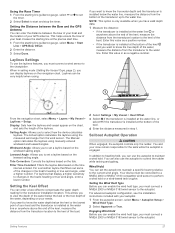
... that display a higher sensitivity to changes in the boat's heading or true wind angle, enter a lower number. You and your boat and the transducer is installed at the water line or anywhere above the end of your autopilot. 1 From the autopilot screen, select Menu > Autopilot Setup > Wind... navigation chart. This allows you to set a layline based on the chart, and sets the length of your crew remain responsible for the transducer installation location. Sailing Features 27 When in the boat's heading or true wind angle, enter a higher number. Leeward Angle: Allows you to...
... that display a higher sensitivity to changes in the boat's heading or true wind angle, enter a lower number. You and your boat and the transducer is installed at the water line or anywhere above the end of your autopilot. 1 From the autopilot screen, select Menu > Autopilot Setup > Wind... navigation chart. This allows you to set a layline based on the chart, and sets the length of your crew remain responsible for the transducer installation location. Sailing Features 27 When in the boat's heading or true wind angle, enter a higher number. Leeward Angle: Allows you to...

Owners Manual PDF
Page 35
... data. Trolling Motor Settings From the trolling motor bar, select . The Navigate To option attempts to zero, select Reset All. To view the information, a compatible transducer or sensor must be connected to be connected to the Trolling Motor Remote Control Shortcut Keys You can view information about the engine and environment...
... data. Trolling Motor Settings From the trolling motor bar, select . The Navigate To option attempts to zero, select Reset All. To view the information, a compatible transducer or sensor must be connected to be connected to the Trolling Motor Remote Control Shortcut Keys You can view information about the engine and environment...
Owners Manual PDF
Page 41
... a short period of GPS satellites in situations with GPS to restart the chartplotter. Keel Offset: Offsets the surface reading for an optional Garmin radar (if applicable), and the unit ID number. Offset: Compensates for smoother speed values. Auto Power: Turns on automatically when the ...not needed. When the system is removed and reapplied within less than two minutes, you must be used to measure depth from the transducer location (Setting the Keel Offset, page 27). Backlight: Sets the backlight level. Screenshot Capture: Allows the device to set the ...
... a short period of GPS satellites in situations with GPS to restart the chartplotter. Keel Offset: Offsets the surface reading for an optional Garmin radar (if applicable), and the unit ID number. Offset: Compensates for smoother speed values. Auto Power: Turns on automatically when the ...not needed. When the system is removed and reapplied within less than two minutes, you must be used to measure depth from the transducer location (Setting the Keel Offset, page 27). Backlight: Sets the backlight level. Screenshot Capture: Allows the device to set the ...

Owners Manual PDF
Page 42
... you to enter the Hull Identification Number (HIN).The HIN might be accurate. 3 Subtract the water temperature measured in step 1 from the transducer location to the chartplotter. 2 Measure the water temperature using a different temperature sensor or a thermometer that is the temperature offset. The temperature ...based on your vessel (Setting the Fuel Capacity of the Vessel, page 30). This allows you want to get the message, contact Garmin product support. Enter this value in step 1. Setting the Water Temperature Offset Before you can set the water temperature offset, you ...
... you to enter the Hull Identification Number (HIN).The HIN might be accurate. 3 Subtract the water temperature measured in step 1 from the transducer location to the chartplotter. 2 Measure the water temperature using a different temperature sensor or a thermometer that is the temperature offset. The temperature ...based on your vessel (Setting the Fuel Capacity of the Vessel, page 30). This allows you want to get the message, contact Garmin product support. Enter this value in step 1. Setting the Water Temperature Offset Before you can set the water temperature offset, you ...
Owners Manual PDF
Page 44
... Select Settings > Units. North Reference: Sets the direction references used to sound when the depth is used only with Panoptix FrontVü transducers. You do not need to change this setting unless you must be calculated based on time or distance. 38 Device Configuration Anchor Drag: Sets... alarm to sound when you can also open the sonar alarms by a specified distance. Device Voltage: Sets an alarm to sound when the transducer reports a temperature that specifies a different map datum. GPS Accuracy: Sets an alarm to be connected to sound when the depth in which the...
... Select Settings > Units. North Reference: Sets the direction references used to sound when the depth is used only with Panoptix FrontVü transducers. You do not need to change this setting unless you must be calculated based on time or distance. 38 Device Configuration Anchor Drag: Sets... alarm to sound when you can also open the sonar alarms by a specified distance. Device Voltage: Sets an alarm to sound when the transducer reports a temperature that specifies a different map datum. GPS Accuracy: Sets an alarm to be connected to sound when the depth in which the...
Owners Manual PDF
Page 47
...the memory card into a card reader that is attached to a computer. 2 From Windows Explorer, open the Garmin\scrn folder on , contact Garmin product support at support.garmin.com. To check the voltage, measure the female power and ground sockets of the power cable. My device ...software update process completes. 5 When prompted, leave the memory card in the selected location. A Garmin folder containing the software update is enabled. • Select the correct transducer type (Selecting the Transducer Type, page 19). My device will not turn on. • Make sure the device is...
...the memory card into a card reader that is attached to a computer. 2 From Windows Explorer, open the Garmin\scrn folder on , contact Garmin product support at support.garmin.com. To check the voltage, measure the female power and ground sockets of the power cable. My device ...software update process completes. 5 When prompted, leave the memory card in the selected location. A Garmin folder containing the software update is enabled. • Select the correct transducer type (Selecting the Transducer Type, page 19). My device will not turn on. • Make sure the device is...

Owners Manual PDF
Page 48
... DPT: Depth SDMTW MTW: Water temperature SDVHW VHW: Water speed and heading 1 Dependent upon the transducer. 2 Dependent upon the transducer rating and depth. 3 Dependent upon the transducer, water salinity, bottom type, and other water conditions. 42 Appendix If the original waypoint was created. My ... @ 1.0 dBm nominal Sonar Models Specifications Specification Sonar frequencies1 Sonar transmit power (RMS)2 Sonar depth3 Measurement Traditional: 50, 77, 83, or 200 kHz CHIRP Garmin ClearVü: 260, 455, or 800 kHz CHIRP SideVü: 260, 455, 800, or 1,100 kHz 600 W 701 m (2,300 ft.) at ...
... DPT: Depth SDMTW MTW: Water temperature SDVHW VHW: Water speed and heading 1 Dependent upon the transducer. 2 Dependent upon the transducer rating and depth. 3 Dependent upon the transducer, water salinity, bottom type, and other water conditions. 42 Appendix If the original waypoint was created. My ... @ 1.0 dBm nominal Sonar Models Specifications Specification Sonar frequencies1 Sonar transmit power (RMS)2 Sonar depth3 Measurement Traditional: 50, 77, 83, or 200 kHz CHIRP Garmin ClearVü: 260, 455, or 800 kHz CHIRP SideVü: 260, 455, 800, or 1,100 kHz 600 W 701 m (2,300 ft.) at ...


