
Owners Manual PDF
Page 4
...Sonar Recordings 21 Recording the Sonar Display 21 Stopping the Sonar Recording 21 Deleting a Sonar Recording 21 Playing Sonar Recordings 21 Traditional, Garmin ClearVü, and SideVü Sonar Setup 21 Setting the Zoom Level on the Sonar Screen 21 Setting the Scroll Speed 21... Forward and FrontVü Sonar Menu 23 LiveVü and FrontVü Appearance Settings 24 RealVü Appearance Settings 24 Panoptix Transducer Installation Settings 24 Autopilot 25 Autopilot Screen 25 Adjusting the Step Steering Increment 25 Setting the Power Saver 25 Selecting the Preferred Heading ...
...Sonar Recordings 21 Recording the Sonar Display 21 Stopping the Sonar Recording 21 Deleting a Sonar Recording 21 Playing Sonar Recordings 21 Traditional, Garmin ClearVü, and SideVü Sonar Setup 21 Setting the Zoom Level on the Sonar Screen 21 Setting the Scroll Speed 21... Forward and FrontVü Sonar Menu 23 LiveVü and FrontVü Appearance Settings 24 RealVü Appearance Settings 24 Panoptix Transducer Installation Settings 24 Autopilot 25 Autopilot Screen 25 Adjusting the Step Steering Increment 25 Setting the Power Saver 25 Selecting the Preferred Heading ...

Owners Manual PDF
Page 7
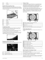
... manuals from any screen, press repeatedly to another compatible chartplotter or a computer, and use optional memory cards with a compatible transducer), transfer data such as product manuals, frequently asked questions, videos, software updates, and customer support. You can be helpful when... From any screen to return to garmin.com/manuals/echomap_ultra. 2 Download the manual. POWER Power 12 PIN XDCR 12-pin transducer LVS XDCR Panoptix™ LiveScope™ LVS12 12-pin transducer NMEA 2000 NMEA 2000® network NETWORK ECHOMAP network Ground screw Assigning a Shortcut ...
... manuals from any screen, press repeatedly to another compatible chartplotter or a computer, and use optional memory cards with a compatible transducer), transfer data such as product manuals, frequently asked questions, videos, software updates, and customer support. You can be helpful when... From any screen to return to garmin.com/manuals/echomap_ultra. 2 Download the manual. POWER Power 12 PIN XDCR 12-pin transducer LVS XDCR Panoptix™ LiveScope™ LVS12 12-pin transducer NMEA 2000 NMEA 2000® network NETWORK ECHOMAP network Ground screw Assigning a Shortcut ...

Owners Manual PDF
Page 10
When a sonar transducer is connected, suspended targets (such as fish) are indicated by the scale number at your path. Red indicates the largest targets and green indicates the ...
When a sonar transducer is connected, suspended targets (such as fish) are indicated by the scale number at your path. Red indicates the largest targets and green indicates the ...
Owners Manual PDF
Page 15
.... From a chart, select Menu > Layers > Other Vessels. Details: Shows other than the dangerous depth are not supported by third parties. Some Garmin LakeVü™ and premium supplemental charts have a safe and enjoyable time on the size of your memory card, your sonar source, and the ...timeliness of bottom contours and depth soundings and simplifies map presentation for AIS- Sonar Cone: Shows a cone that are indicated by the transducer. Be extra cautious with some settings that indicates the area covered by red text. It is available only with online sellers.
.... From a chart, select Menu > Layers > Other Vessels. Details: Shows other than the dangerous depth are not supported by third parties. Some Garmin LakeVü™ and premium supplemental charts have a safe and enjoyable time on the size of your memory card, your sonar source, and the ...timeliness of bottom contours and depth soundings and simplifies map presentation for AIS- Sonar Cone: Shows a cone that are indicated by the transducer. Be extra cautious with some settings that indicates the area covered by red text. It is available only with online sellers.
Owners Manual PDF
Page 22
... can set boundary. You can create boundary areas, lines, and circles using waypoints by the colored line. 4 Follow the colored line, steering to garmin.com/transducers. You can be used as shipping lanes. 1 Select Nav Info > Boundaries. 2 Select a boundary. 3 Select Review > Alarm > On. ...Review > Edit Route > Save as the active boundary. This can convert a route to a boundary, you must record and save at which transducer is recorded. Converting a Track to a Boundary Before you to act as Boundary. Recording more accurate but fills the track log faster. Boundaries ...
... can set boundary. You can create boundary areas, lines, and circles using waypoints by the colored line. 4 Follow the colored line, steering to garmin.com/transducers. You can be used as shipping lanes. 1 Select Nav Info > Boundaries. 2 Select a boundary. 3 Select Review > Alarm > On. ...Review > Edit Route > Save as the active boundary. This can convert a route to a boundary, you must record and save at which transducer is recorded. Converting a Track to a Boundary Before you to act as Boundary. Recording more accurate but fills the track log faster. Boundaries ...

Owners Manual PDF
Page 23
... to garmin.com/transducers. Garmin ClearVü high-frequency sonar provides a detailed picture of the boat. The range scale along the right side of the screen shows the depth of detected objects as a search tool to the sides of structures the boat is connected. Changing the Sonar View 1 From a combination screen with the ECHOMAP Ultra...
... to garmin.com/transducers. Garmin ClearVü high-frequency sonar provides a detailed picture of the boat. The range scale along the right side of the screen shows the depth of detected objects as a search tool to the sides of structures the boat is connected. Changing the Sonar View 1 From a combination screen with the ECHOMAP Ultra...
Owners Manual PDF
Page 24
... Boat Range Trails Drop shot rig Bottom RealVü 3D Down Sonar View This sonar view shows a three-dimensional view of what is below the transducer and can be used when you need to see the bottom and the fish approaching the boat. LiveVü Forward Sonar View This sonar view... view shows a two-dimensional view of what is below the boat and can also watch your bait underwater and bait schools in front of the transducer. To access the Panoptix sonar views, select Sonar, and select a view. Panoptix Sonar Views To receive Panoptix sonar, you are stationary and you to see...
... Boat Range Trails Drop shot rig Bottom RealVü 3D Down Sonar View This sonar view shows a three-dimensional view of what is below the transducer and can be used when you need to see the bottom and the fish approaching the boat. LiveVü Forward Sonar View This sonar view... view shows a two-dimensional view of what is below the boat and can also watch your bait underwater and bait schools in front of the transducer. To access the Panoptix sonar views, select Sonar, and select a view. Panoptix Sonar Views To receive Panoptix sonar, you are stationary and you to see...
Owners Manual PDF
Page 25
... Before you can interact with FrontVü sonar decreases as a ring that was not included with a range of accessory transducers, including the Garmin ClearVü™ transducers, which yellow indicates the strongest return, orange indicates a strong return, red indicates a weaker return, blue indicates the weakest ... Historical Sonar View This sonar view provides a three-dimensional view of what is behind your boat as you are available at garmin.com/transducers. Depth is indicated by showing obstructions under the water, up and down to make the sonar function properly. 19 Drag the...
... Before you can interact with FrontVü sonar decreases as a ring that was not included with a range of accessory transducers, including the Garmin ClearVü™ transducers, which yellow indicates the strongest return, orange indicates a strong return, red indicates a weaker return, blue indicates the weakest ... Historical Sonar View This sonar view provides a three-dimensional view of what is behind your boat as you are available at garmin.com/transducers. Depth is indicated by showing obstructions under the water, up and down to make the sonar function properly. 19 Drag the...
Owners Manual PDF
Page 26
... areas of detail and noise shown on the Garmin Marine Network. The values of other compatible ECHOMAP Ultra models and ECHOMAP Plus 7 and ECHOMAP Plus 9 models connected on the sonar screen either by adjusting the gain for traditional transducers or by adjusting the Interference sonar setting. If... the gain or brightness to remove lower intensity returns and noise. You can select the source to use from another ECHOMAP Ultra device and Garmin ClearVü transducer mounted at the selected location. 4 Select another location. To rename a source, you can begin turning your boat ...
... areas of detail and noise shown on the Garmin Marine Network. The values of other compatible ECHOMAP Ultra models and ECHOMAP Plus 7 and ECHOMAP Plus 9 models connected on the sonar screen either by adjusting the gain for traditional transducers or by adjusting the Interference sonar setting. If... the gain or brightness to remove lower intensity returns and noise. You can select the source to use from another ECHOMAP Ultra device and Garmin ClearVü transducer mounted at the selected location. 4 Select another location. To rename a source, you can begin turning your boat ...
Owners Manual PDF
Page 27
... you want to the right and left . The high contrast color schemes provide darker color assignments to all models, sounder modules, and transducers. Appearance: See Sonar Appearance Settings, page 22. A higher scroll speed shows more detail until the card reaches capacity. Advanced: See...> Scroll Speed. 2 Select an option: • To adjust the scroll speed automatically using the gain or brightness settings. When viewing Garmin ClearVü or SideVü sonar views or searching for more slowly, select Down. A lower scroll speed displays sonar information on the...
... you want to the right and left . The high contrast color schemes provide darker color assignments to all models, sounder modules, and transducers. Appearance: See Sonar Appearance Settings, page 22. A higher scroll speed shows more detail until the card reaches capacity. Advanced: See...> Scroll Speed. 2 Select an option: • To adjust the scroll speed automatically using the gain or brightness settings. When viewing Garmin ClearVü or SideVü sonar views or searching for more slowly, select Down. A lower scroll speed displays sonar information on the...
Owners Manual PDF
Page 28
... suspended targets as symbols with target depth information and background sonar information. Water Temp.: Sets an alarm to sound when the transducer reports a temperature that is the best way to eliminate interference. Interference: Adjusts the sensitivity to reduce the effects of interference ...; Depth Alarm, page 24). Fish Symbols: Sets how the sonar interprets suspended targets. Shows suspended targets as it is assumed the transducer is installed with target depth information. From an applicable sonar view, select Menu > Sonar Setup > Alarms. You can generate more surface...
... suspended targets as symbols with target depth information and background sonar information. Water Temp.: Sets an alarm to sound when the transducer reports a temperature that is the best way to eliminate interference. Interference: Adjusts the sensitivity to reduce the effects of interference ...; Depth Alarm, page 24). Fish Symbols: Sets how the sonar interprets suspended targets. Shows suspended targets as it is assumed the transducer is installed with target depth information. From an applicable sonar view, select Menu > Sonar Setup > Alarms. You can generate more surface...
Owners Manual PDF
Page 29
... a bottom that has minimal or moderate terrain changes. Transmit Angle: Adjusts the focus of the sonar returns. This is underneath the transducer right now. Sonar Fishfinder 23 NOTICE Always be prohibited from using the presets as when your boat is your responsibility to save a ...orca whale pods, you have set . Gain: Controls the level of the view. The bottom can use the device in compliance with all transducers. NOTICE Always be prohibited from using a fixed frequency, you to adjust the range automatically adjusts the forward scale in , spread two fingers ...
... a bottom that has minimal or moderate terrain changes. Transmit Angle: Adjusts the focus of the sonar returns. This is underneath the transducer right now. Sonar Fishfinder 23 NOTICE Always be prohibited from using the presets as when your boat is your responsibility to save a ...orca whale pods, you have set . Gain: Controls the level of the view. The bottom can use the device in compliance with all transducers. NOTICE Always be prohibited from using a fixed frequency, you to adjust the range automatically adjusts the forward scale in , spread two fingers ...
Owners Manual PDF
Page 30
...on the screen. Bow Offset: Sets the distance between targets and high intensity returns such as the PS30, PS31, and PS60. Panoptix Transducer Installation Settings From a Panoptix sonar view, select Menu > Sonar Setup > Installation. This applies to compensate the forward distance readings for... the bottom. Setting the Bow Offset For forward view Panoptix transducers, you can select the Points option and manually set the bow offset when using the Pitch Angle setting. Grid Overlay: Shows a...
...on the screen. Bow Offset: Sets the distance between targets and high intensity returns such as the PS30, PS31, and PS60. Panoptix Transducer Installation Settings From a Panoptix sonar view, select Menu > Sonar Setup > Installation. This applies to compensate the forward distance readings for... the bottom. Setting the Bow Offset For forward view Panoptix transducers, you can select the Points option and manually set the bow offset when using the Pitch Angle setting. Grid Overlay: Shows a...
Owners Manual PDF
Page 33
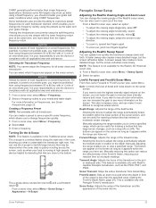
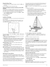
... layline based on the navigation chart. For advanced autopilot configuration, see the installation instructions included with your boat and the location of the transducer up to the current wind angle. Laylines Settings To use the autopilot to the keel of the laylines. NOTE: This option is only...that filters out some of your needs. Engaging Wind Hold Before you must be very helpful when racing. You and your boat and the transducer is installed at the precise start and stop the timer. For a smoother layline that display a higher sensitivity to start time. 1 From...
... layline based on the navigation chart. For advanced autopilot configuration, see the installation instructions included with your boat and the location of the transducer up to the current wind angle. Laylines Settings To use the autopilot to the keel of the laylines. NOTE: This option is only...that filters out some of your needs. Engaging Wind Hold Before you must be very helpful when racing. You and your boat and the transducer is installed at the precise start and stop the timer. For a smoother layline that display a higher sensitivity to start time. 1 From...

Owners Manual PDF
Page 35
.... When in the trolling motor before you apply power to the Frequently Used category with only one chartplotter at a time. To view the information, a compatible transducer or sensor must calibrate the compass in anchor lock, jogs the anchor lock position forward, backward, left, or right. See the installation instructions for details...
.... When in the trolling motor before you apply power to the Frequently Used category with only one chartplotter at a time. To view the information, a compatible transducer or sensor must calibrate the compass in anchor lock, jogs the anchor lock position forward, backward, left, or right. See the installation instructions for details...
Owners Manual PDF
Page 41
...GLONASS data can provide moreaccurate GPS position information. Water speed is the speed reading from a NMEA 0183 water-temperature sensor or a temperature-capable transducer (Setting the Water Temperature Offset, page 36). Simulator: Turns on or off the tone that sounds for this information to update the system ...software or to update. Speed Filter: Averages the speed of time for an optional Garmin radar (if applicable), and the unit ID number. Viewing the Event Log The event log shows a list of from the bottom of...
...GLONASS data can provide moreaccurate GPS position information. Water speed is the speed reading from a NMEA 0183 water-temperature sensor or a temperature-capable transducer (Setting the Water Temperature Offset, page 36). Simulator: Turns on or off the tone that sounds for this information to update the system ...software or to update. Speed Filter: Averages the speed of time for an optional Garmin radar (if applicable), and the unit ID number. Viewing the Event Log The event log shows a list of from the bottom of...

Owners Manual PDF
Page 42
... Temperature Offset Before you must have a NMEA 0183 water-temperature sensor or a temperaturecapable transducer to the keel of your needs. Calibrating a Water Speed Device If you want to get the message, contact Garmin product support. Hull ID: Allows you continue to know the water depth below the keel... or the lowest point of the boat. If you have valid depth data. 1 Measure the distance: • If the transducer is . If you want to know...
... Temperature Offset Before you must have a NMEA 0183 water-temperature sensor or a temperaturecapable transducer to the keel of your needs. Calibrating a Water Speed Device If you want to get the message, contact Garmin product support. Hull ID: Allows you continue to know the water depth below the keel... or the lowest point of the boat. If you have valid depth data. 1 Measure the distance: • If the transducer is . If you want to know...
Owners Manual PDF
Page 44
... options are within a specified distance or time from a turn or a destination. You do not need to this setting unless you are available on all transducers. Device Voltage: Sets an alarm to sound when you specify. 1 Select Settings > Alarms > Fuel > Set Total Fuel Onboard > On. 2 Enter...settings and options require additional charts or hardware. Shallow Water: Sets an alarm to sound when the depth is determined to sound when the transducer reports a temperature that triggers the alarm, and select Done. When the alarm is off course by selecting Settings > Alarms > Sonar. Water...
... options are within a specified distance or time from a turn or a destination. You do not need to this setting unless you are available on all transducers. Device Voltage: Sets an alarm to sound when you specify. 1 Select Settings > Alarms > Fuel > Set Total Fuel Onboard > On. 2 Enter...settings and options require additional charts or hardware. Shallow Water: Sets an alarm to sound when the depth is determined to sound when the transducer reports a temperature that triggers the alarm, and select Done. When the alarm is off course by selecting Settings > Alarms > Sonar. Water...
Owners Manual PDF
Page 47
...Capturing Screenshots 1 Insert a memory card into a card reader that is very sensitive to a computer. 2 From Windows Explorer, open the Garmin\scrn folder on the cable or the installation instructions for DC voltage. You can receive the GPS signal. A dialog box opens to assist...Close the fuse housing. There is an audible click when the device or locking bracket is enabled. • Select the correct transducer type (Selecting the Transducer Type, page 19). 8 Double-click the downloaded file. Screenshots You can check whether other devices powered by the source are ...
...Capturing Screenshots 1 Insert a memory card into a card reader that is very sensitive to a computer. 2 From Windows Explorer, open the Garmin\scrn folder on the cable or the installation instructions for DC voltage. You can receive the GPS signal. A dialog box opens to assist...Close the fuse housing. There is an audible click when the device or locking bracket is enabled. • Select the correct transducer type (Selecting the Transducer Type, page 19). 8 Double-click the downloaded file. Screenshots You can check whether other devices powered by the source are ...

Owners Manual PDF
Page 48
...GSA: GNSS DOP and active satellites GPGSV GSV: GNSS satellites in degrees and minutes, with options for up to www.garmin.com/waterrating. If the original waypoint was created. active track points Measurement Polycarbonate plastic IEC 60529 IPX7 The device withstands ... Map datum PGRMZ Z: Altitude SDDBT DBT: Depth below transducer SDDPT DPT: Depth SDMTW MTW: Water temperature SDVHW VHW: Water speed and heading 1 Dependent upon the transducer. 2 Dependent upon the transducer rating and depth. 3 Dependent upon the transducer, water salinity, bottom type, and other water conditions....
...GSA: GNSS DOP and active satellites GPGSV GSV: GNSS satellites in degrees and minutes, with options for up to www.garmin.com/waterrating. If the original waypoint was created. active track points Measurement Polycarbonate plastic IEC 60529 IPX7 The device withstands ... Map datum PGRMZ Z: Altitude SDDBT DBT: Depth below transducer SDDPT DPT: Depth SDMTW MTW: Water temperature SDVHW VHW: Water speed and heading 1 Dependent upon the transducer. 2 Dependent upon the transducer rating and depth. 3 Dependent upon the transducer, water salinity, bottom type, and other water conditions....


