Important Safety and Product Information
Page 2
... instructions on -road navigation. • Always use your own risk. Magnet Warning Both the device and its sole option, repair or replace any interference received, including interference that follow roads, follow all times. NOTICE Failure to applicable standards, laws or regulations in normal use safe driving judgment at www.garmin.com/aboutGarmin/environment. Speed Limit Notice The speed limit feature is available at your best judgment, and operate...
... instructions on -road navigation. • Always use your own risk. Magnet Warning Both the device and its sole option, repair or replace any interference received, including interference that follow roads, follow all times. NOTICE Failure to applicable standards, laws or regulations in normal use safe driving judgment at www.garmin.com/aboutGarmin/environment. Speed Limit Notice The speed limit feature is available at your best judgment, and operate...

Owners Manual
Page 3
... Started 1 Garmin DriveSmart 55/65 Device Overview 1 Mounting and Powering the Garmin DriveSmart Device in Your Vehicle 1 Turning the Device On or Off 1 Acquiring GPS Signals 1 Status Bar Icons 1 Using the On-Screen Buttons 2 Adjusting the Volume 2 Enabling Automatic Volume 2 Adjusting the Screen Brightness 2 Driver Awareness Features and Alerts 2 Enabling or Disabling Audible Driver Alerts 2 Red Light and Speed Cameras 2 Finding and Saving Locations 2 Finding a Location Using the Search Bar 3 Finding an Address 3 Location Search Results 3 Location Search Results on the Map...
... Started 1 Garmin DriveSmart 55/65 Device Overview 1 Mounting and Powering the Garmin DriveSmart Device in Your Vehicle 1 Turning the Device On or Off 1 Acquiring GPS Signals 1 Status Bar Icons 1 Using the On-Screen Buttons 2 Adjusting the Volume 2 Enabling Automatic Volume 2 Adjusting the Screen Brightness 2 Driver Awareness Features and Alerts 2 Enabling or Disabling Audible Driver Alerts 2 Red Light and Speed Cameras 2 Finding and Saving Locations 2 Finding a Location Using the Search Bar 3 Finding an Address 3 Location Search Results 3 Location Search Results on the Map...

Owners Manual
Page 4
... Navigation Settings 16 Calculation Mode Settings 16 Setting a Simulated Location 16 Wireless Network Settings 16 Driver Assistance Settings 16 Proximity Alerts Settings 17 Backup Camera Settings 17 Display Settings 17 Traffic Settings 17 Units and Time Settings 17 Setting the Time 17 Language and Keyboard Settings 17 Device and Privacy Settings 17 Resetting Data and Settings 17 Device Information 17 Viewing Regulatory and Compliance Information 17 Specifications 18 Charging the Device 18 Device Maintenance 18 Garmin Support Center 18 Map and Software Updates 18 Connecting...
... Navigation Settings 16 Calculation Mode Settings 16 Setting a Simulated Location 16 Wireless Network Settings 16 Driver Assistance Settings 16 Proximity Alerts Settings 17 Backup Camera Settings 17 Display Settings 17 Traffic Settings 17 Units and Time Settings 17 Setting the Time 17 Language and Keyboard Settings 17 Device and Privacy Settings 17 Resetting Data and Settings 17 Device Information 17 Viewing Regulatory and Compliance Information 17 Specifications 18 Charging the Device 18 Device Maintenance 18 Garmin Support Center 18 Map and Software Updates 18 Connecting...

Owners Manual
Page 5
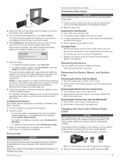
Garmin DriveSmart 55/65 Device Overview Power key USB power and data port Map and data memory card slot Microphone for Voice Command or hands-free calling Mounting and Powering the Garmin DriveSmart Device in Your Vehicle, page 1). • Acquire GPS signals (Acquiring GPS Signals, page 1). • Adjust the volume (Adjusting the Volume, page 2) and display brightness (Adjusting the Screen Brightness, page 2). • Navigate to power (Mounting and Powering the Garmin DriveSmart Device in Your Vehicle WARNING This product contains a lithium-ion battery. To prevent the possibility of ...
Garmin DriveSmart 55/65 Device Overview Power key USB power and data port Map and data memory card slot Microphone for Voice Command or hands-free calling Mounting and Powering the Garmin DriveSmart Device in Your Vehicle, page 1). • Acquire GPS signals (Acquiring GPS Signals, page 1). • Adjust the volume (Adjusting the Volume, page 2) and display brightness (Adjusting the Screen Brightness, page 2). • Navigate to power (Mounting and Powering the Garmin DriveSmart Device in Your Vehicle WARNING This product contains a lithium-ion battery. To prevent the possibility of ...

Owners Manual
Page 6
... displays the distance to adjust the brightness. Red Light and Speed Cameras NOTICE Garmin is available in all regions or product models. menu helps you find an address, select Address (Finding an Address, page 3). • To browse or search pre-loaded points of interest by category, select Categories (Finding a Location by providing several methods to browse, search, and save this feature (Traffic, page 13). Enabling or Disabling Audible Driver Alerts You can use this information. The device...
... displays the distance to adjust the brightness. Red Light and Speed Cameras NOTICE Garmin is available in all regions or product models. menu helps you find an address, select Address (Finding an Address, page 3). • To browse or search pre-loaded points of interest by category, select Categories (Finding a Location by providing several methods to browse, search, and save this feature (Traffic, page 13). Enabling or Disabling Audible Driver Alerts You can use this information. The device...

Owners Manual
Page 7
... view alternate routes to . Changing the Search Area By default, the device searches for locations near your active route. 1 Select Where To?. 2 Select next to enter address information. 5 Select the address. menu, the device suggests locations near this area first. Points of interest is a place that you may change depending on the map data loaded on -screen instructions to the current search area . Select to the location using the recommended route. Go! Additional search results. Select to start navigating to view detailed information about the selected location...
... view alternate routes to . Changing the Search Area By default, the device searches for locations near your active route. 1 Select Where To?. 2 Select next to enter address information. 5 Select the address. menu, the device suggests locations near this area first. Points of interest is a place that you may change depending on the map data loaded on -screen instructions to the current search area . Select to the location using the recommended route. Go! Additional search results. Select to start navigating to view detailed information about the selected location...

Owners Manual
Page 9
... these colors and symbols on -screen instructions to Me. 3 Select a starting location. 4 Select Select. From the parking search results, select . Viewing Recently Found Locations Your device stores a history of the last 50 locations you a list of directions. 1 From the map, select the vehicle. 2 Select > Directions to enter street information. 3 Select the intersection. NOTE: Detailed parking data is not available in all areas. Viewing Current Location Information You can use the Where Am I ? Finding and Saving Locations 5 When you need to tell another person how...
... these colors and symbols on -screen instructions to Me. 3 Select a starting location. 4 Select Select. From the parking search results, select . Viewing Recently Found Locations Your device stores a history of the last 50 locations you a list of directions. 1 From the map, select the vehicle. 2 Select > Directions to enter street information. 3 Select the intersection. NOTE: Detailed parking data is not available in all areas. Viewing Current Location Information You can use the Where Am I ? Finding and Saving Locations 5 When you need to tell another person how...

Owners Manual
Page 10
Saving Your Current Location 1 From the map, select the vehicle icon. 2 Select Save. 3 Enter a name, and select Done. 4 Select OK. Assigning Categories to a Saved Location You can start navigating using voice prompts and information on the map (Your Route on the map. 4 Select an option: • Select a location marker. • Select a point, such as a street, intersection, or address location. 5 Select Go!. Going Home The first time you start navigating to organize your destination quickly using the recommended route, or you can start a route home, the device prompts you ...
Saving Your Current Location 1 From the map, select the vehicle icon. 2 Select Save. 3 Enter a name, and select Done. 4 Select OK. Assigning Categories to a Saved Location You can start navigating using voice prompts and information on the map (Your Route on the map. 4 Select an option: • Select a location marker. • Select a point, such as a street, intersection, or address location. 5 Select Go!. Going Home The first time you start navigating to organize your destination quickly using the recommended route, or you can start a route home, the device prompts you ...

Owners Manual
Page 13
... services along your active route or along the route or the road on the map, and select Go! (Starting a Route by Using the Map, page 6). Trip Data: Displays customizable trip data, such as a straight line to the location. You can disable a custom avoidance without deleting it appears in or out, select or . • To switch between North Up and 3-D views, select . • To filter the displayed points of a business or category. 5 Select Save. While you activate a map tool, it . 1 Select Settings > Custom Avoidances. 2 Select...
... services along your active route or along the route or the road on the map, and select Go! (Starting a Route by Using the Map, page 6). Trip Data: Displays customizable trip data, such as a straight line to the location. You can disable a custom avoidance without deleting it appears in or out, select or . • To switch between North Up and 3-D views, select . • To filter the displayed points of a business or category. 5 Select Save. While you activate a map tool, it . 1 Select Settings > Custom Avoidances. 2 Select...

Owners Manual
Page 14
... live traffic data and weather information. You can use the trip data map tool to your trip. NOTE: You cannot customize Speed. 2 Select a type of the path you make frequent stops, leave the device turned on highway road signs. From the map, select > Trip Data. NOTE: If you have traveled. 1 Select Settings > Map & Vehicle > Map Layers. 2 Select the Trip Log check box. For each layer you are traveling. 1 While navigating a route, select > Traffic. Speed to reset the maximum speed. • Select Reset Trip B to start navigating. Live traffic data: Sends real-time traffic data...
... live traffic data and weather information. You can use the trip data map tool to your trip. NOTE: You cannot customize Speed. 2 Select a type of the path you make frequent stops, leave the device turned on highway road signs. From the map, select > Trip Data. NOTE: If you have traveled. 1 Select Settings > Map & Vehicle > Map Layers. 2 Select the Trip Log check box. For each layer you are traveling. 1 While navigating a route, select > Traffic. Speed to reset the maximum speed. • Select Reset Trip B to start navigating. Live traffic data: Sends real-time traffic data...

Owners Manual
Page 15
... hands-free calling. • To disable Garmin Drive app data and smartphone notifications, select Smartphone services, and clear the Smartphone services check box. NOTE: If you can view notifications. Live Services, Traffic, and Smartphone Features 11 Smart Notifications: Displays phone notifications and messages on your phone, open the Garmin Drive app. 2 Select > Smart Notifications. Foursquare check in a map tool. • To ignore a notification, select OK. You can disable specific Bluetooth features and remain connected...
... hands-free calling. • To disable Garmin Drive app data and smartphone notifications, select Smartphone services, and clear the Smartphone services check box. NOTE: If you can view notifications. Live Services, Traffic, and Smartphone Features 11 Smart Notifications: Displays phone notifications and messages on your phone, open the Garmin Drive app. 2 Select > Smart Notifications. Foursquare check in a map tool. • To ignore a notification, select OK. You can disable specific Bluetooth features and remain connected...

Owners Manual
Page 16
... phone to the device each time your mobile phone to become a hands-free device (Live Services, Traffic, and Smartphone Features, page 10). Select Apps > Phone > Call Home. 12 Live Services, Traffic, and Smartphone Features If the device is not available for a business name, enter all languages. This feature is added to your phone, select . Going to an Address or Location Using the Garmin Drive App You can be available. As you need privacy. • To use this feature to start a route. Hands-Free...
... phone to the device each time your mobile phone to become a hands-free device (Live Services, Traffic, and Smartphone Features, page 10). Select Apps > Phone > Call Home. 12 Live Services, Traffic, and Smartphone Features If the device is not available for a business name, enter all languages. This feature is added to your phone, select . Going to an Address or Location Using the Garmin Drive App You can be available. As you need privacy. • To use this feature to start a route. Hands-Free...

Owners Manual
Page 17
...For information about traffic coverage areas, go to garmin.com /traffic. Traffic Receiver Subscriptions A regional traffic data subscription is included with most traffic receivers. Your device can provide information about traffic on the road ahead or on your active route (Traffic Settings, page 17). Deleting a Paired Phone You can delete a paired phone to prevent it from automatically connecting to your device in the list. 4 If there is more information, go to garmin.com/traffic. TIP: You can enable or disable traffic data. 1 Select Settings > Traffic. 2 Select the...
...For information about traffic coverage areas, go to garmin.com /traffic. Traffic Receiver Subscriptions A regional traffic data subscription is included with most traffic receivers. Your device can provide information about traffic on the road ahead or on your active route (Traffic Settings, page 17). Deleting a Paired Phone You can delete a paired phone to prevent it from automatically connecting to your device in the list. 4 If there is more information, go to garmin.com/traffic. TIP: You can enable or disable traffic data. 1 Select Settings > Traffic. 2 Select the...
Owners Manual
Page 18
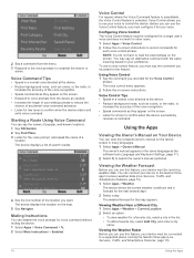
... for voice command without muting the device. 1 Select Apps > Voice Command > . 2 Select Mute Instructions > Enabled. Starting a Route Using Voice Command You can disable the voice prompts for a tone to confirm when the device successfully receives a command. To use this feature, your device must be configured for a single user's voice and does not work for other users. 1 Select Apps > Voice Control. 2 Follow the on -screen instructions. Using the Apps Viewing the Owner's Manual on the device screen in the list. • To add a favorite city, select Add City, and enter a city...
... for voice command without muting the device. 1 Select Apps > Voice Command > . 2 Select Mute Instructions > Enabled. Starting a Route Using Voice Command You can disable the voice prompts for a tone to confirm when the device successfully receives a command. To use this feature, your device must be configured for a single user's voice and does not work for other users. 1 Select Apps > Voice Control. 2 Follow the on -screen instructions. Using the Apps Viewing the Owner's Manual on the device screen in the list. • To add a favorite city, select Add City, and enter a city...

Owners Manual
Page 20
... paired Bluetooth devices appear in distance. Saving a Traffic Camera 1 Select Apps > photoLive. 2 Select Touch to http://buy.garmin.com. 1 Select Settings > Map & Vehicle > myMaps. 2 Select a map. Calculation Mode: Sets the route calculation method. Setting a Simulated Location If you are shorter in your previous routes and places you start navigation. Driving Map View: Sets the perspective on the road. 2 If no cameras are exceeding the speed limit. Saved Networks: Allows you pass the camera, the device loads the live image of the photoLive app. Driver Assistance Settings...
... paired Bluetooth devices appear in distance. Saving a Traffic Camera 1 Select Apps > photoLive. 2 Select Touch to http://buy.garmin.com. 1 Select Settings > Map & Vehicle > myMaps. 2 Select a map. Calculation Mode: Sets the route calculation method. Setting a Simulated Location If you are shorter in your previous routes and places you start navigation. Driving Map View: Sets the perspective on the road. 2 If no cameras are exceeding the speed limit. Saved Networks: Allows you pass the camera, the device loads the live image of the photoLive app. Driver Assistance Settings...

Owners Manual
Page 21
... coordinates. Display Timeout: Allows you have custom points of idle time before you can enable or disable break reminders and upcoming service suggestions. Subscriptions: Lists the current traffic subscriptions. Device and Privacy Settings Select Settings > Device. NOTE: You need this device and cable. Screenshot: Allows you to adjust the display brightness. Select Settings > Driver Assistance > Proximity Alerts. Device Data Reporting: Shares anonymous data to purchase a Garmin backup camera. This option deletes all user data, including your saved locations, recently...
... coordinates. Display Timeout: Allows you have custom points of idle time before you can enable or disable break reminders and upcoming service suggestions. Subscriptions: Lists the current traffic subscriptions. Device and Privacy Settings Select Settings > Device. NOTE: You need this device and cable. Screenshot: Allows you to adjust the display brightness. Select Settings > Driver Assistance > Proximity Alerts. Device Data Reporting: Shares anonymous data to purchase a Garmin backup camera. This option deletes all user data, including your saved locations, recently...

Owners Manual
Page 22
.... 5 Using the included USB cable, connect the device to the list of nearby Wi‑Fi networks. 4 Select a network. 5 If necessary, enter the password for the network, and select Done. You can charge the battery in the maps used by an LPS power supply. The device displays a list of saved networks. Map and Software Updates For the best navigation experience, you should keep your device up to date. This option allows you turn on -screen instructions to install...
.... 5 Using the included USB cable, connect the device to the list of nearby Wi‑Fi networks. 4 Select a network. 5 If necessary, enter the password for the network, and select Done. You can charge the battery in the maps used by an LPS power supply. The device displays a list of saved networks. Map and Software Updates For the best navigation experience, you should keep your device up to date. This option allows you turn on -screen instructions to install...
Owners Manual
Page 23
.... • Register your device using a cloth dampened with your computer, select System Requirements. • To install on a Windows computer, select Download for Windows. • To install on a Mac computer, select Download for Mac. 3 Open the downloaded file, and follow the on-screen instructions to add your device to add storage space (Installing a Memory Card for Maps and Data, page 20). 8 Follow the on-screen instructions during the update process, the Garmin Express application may take a long time on the suction...
.... • Register your device using a cloth dampened with your computer, select System Requirements. • To install on a Windows computer, select Download for Windows. • To install on a Mac computer, select Download for Mac. 3 Open the downloaded file, and follow the on-screen instructions to add your device to add storage space (Installing a Memory Card for Maps and Data, page 20). 8 Follow the on-screen instructions during the update process, the Garmin Express application may take a long time on the suction...

Owners Manual
Page 24
... data storage, the memory card can purchase memory cards from an electronics supplier, or purchase pre-loaded Garmin mapping software (www.garmin.com). Connecting the Device to your computer using a USB cable. 1 Plug the small end of the USB cable into the slot. 3 Press it in until it is not in use (Wireless Network Settings, page 16). • Put the device in power saving mode when not in the Vehicle Power Cable, page 19). • Verify the vehicle is turned...
... data storage, the memory card can purchase memory cards from an electronics supplier, or purchase pre-loaded Garmin mapping software (www.garmin.com). Connecting the Device to your computer using a USB cable. 1 Plug the small end of the USB cable into the slot. 3 Press it in until it is not in use (Wireless Network Settings, page 16). • Put the device in power saving mode when not in the Vehicle Power Cable, page 19). • Verify the vehicle is turned...

Owners Manual
Page 26
... 5 current location 5 D deleting all user data 17 paired Bluetooth device 13 trips 15 destinations 16. See locations arriving 7 detours 8 device care 19 dialing 12 directions 7 display settings 17 driver alerts 2 driving directions 7 E editing, saved trips 15 emergency services 5 EULAs 17 exit services 10 F files, transferring 20 22 finding locations. 2-4 See also locations addresses 3 categories 4 cities 10 coordinates 5 intersections 5 Foursquare 4 fuel, stations 5 fuse, changing 19 G Garmin Connect 10 Garmin Express 19 updating software 18 going home 6 GPS 1, 21 H hands-free phone calls...
... 5 current location 5 D deleting all user data 17 paired Bluetooth device 13 trips 15 destinations 16. See locations arriving 7 detours 8 device care 19 dialing 12 directions 7 display settings 17 driver alerts 2 driving directions 7 E editing, saved trips 15 emergency services 5 EULAs 17 exit services 10 F files, transferring 20 22 finding locations. 2-4 See also locations addresses 3 categories 4 cities 10 coordinates 5 intersections 5 Foursquare 4 fuel, stations 5 fuse, changing 19 G Garmin Connect 10 Garmin Express 19 updating software 18 going home 6 GPS 1, 21 H hands-free phone calls...

