Important Product and Safety Information (Multilingual)
Page 2
... Proposition 65. In addition, the GPS unit may use of California to cause • Do not use voice prompts when possible. If your product contains or accepts street maps. contain chemicals known to the State of the unit's controls while navigating. NOTE: Refer to your local ...Keep the batteries away from street signs, visual sightings, and maps. Warning: This product, its packaging, and its components glove box. See www.garmin.com/prop65 for various purposes, such as the steering wheel, foot pedals, or transmission levers. Using other factors that may present a risk of...
... Proposition 65. In addition, the GPS unit may use of California to cause • Do not use voice prompts when possible. If your product contains or accepts street maps. contain chemicals known to the State of the unit's controls while navigating. NOTE: Refer to your local ...Keep the batteries away from street signs, visual sightings, and maps. Warning: This product, its packaging, and its components glove box. See www.garmin.com/prop65 for various purposes, such as the steering wheel, foot pedals, or transmission levers. Using other factors that may present a risk of...
Owner's Manual
Page 4
...Conventions i Getting Started 1 Product Registration 1 Contact Garmin 1 Optional Accessories 1 Caring for the Dakota 1 Battery Information 2 Turning On and Off the Dakota 2 Adjusting the Backlight Level..... 3 Locking the Screen 3 Acquiring GPS Satellite Signals 3 Basic Navigation 4 Accessing Applications from the Main menu 4 Creating Waypoints 4 Navigating to a Destination........ 5 Stop Navigating 7 Using the Map 7 Using the Compass 9... 17 Calculating the Size of an Area 17 Other Tools 17 Monitoring Satellite Reception 18 Trip Computer 19 ii Dakota Series Owner's Manual
...Conventions i Getting Started 1 Product Registration 1 Contact Garmin 1 Optional Accessories 1 Caring for the Dakota 1 Battery Information 2 Turning On and Off the Dakota 2 Adjusting the Backlight Level..... 3 Locking the Screen 3 Acquiring GPS Satellite Signals 3 Basic Navigation 4 Accessing Applications from the Main menu 4 Creating Waypoints 4 Navigating to a Destination........ 5 Stop Navigating 7 Using the Map 7 Using the Compass 9... 17 Calculating the Size of an Area 17 Other Tools 17 Monitoring Satellite Reception 18 Trip Computer 19 ii Dakota Series Owner's Manual
Owner's Manual
Page 9
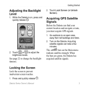
... to change the backlight timeout. Acquiring satellite signals can find your current location and navigate a route, you must acquire GPS signals. 1. The bars on the Dakota. Turn on the Main menu indicate satellite strength. When the bars are green, the Dakota has acquired satellite signals. Press and quickly release . See page 22 to an...
... to change the backlight timeout. Acquiring satellite signals can find your current location and navigate a route, you must acquire GPS signals. 1. The bars on the Dakota. Turn on the Main menu indicate satellite strength. When the bars are green, the Dakota has acquired satellite signals. Press and quickly release . See page 22 to an...
Owner's Manual
Page 15
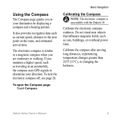
... such as cars, buildings, or overhead power lines. The electronic compass is unavailable with the Dakota 10. Basic Navigation Calibrating the Compass note: The electronic compass is similar to the next point on the route, and estimated arrival time. Do not...such as traveling in an automobile, the compass uses GPS signals to your direction. To turn the electronic compass off, see page 28. Calibrate the electronic compass outdoors. Calibrate the compass after moving long distances, experiencing temperature changes greater than 20°F (11°C), or changing the batteries. Using...
... such as cars, buildings, or overhead power lines. The electronic compass is unavailable with the Dakota 10. Basic Navigation Calibrating the Compass note: The electronic compass is similar to the next point on the route, and estimated arrival time. Do not...such as traveling in an automobile, the compass uses GPS signals to your direction. To turn the electronic compass off, see page 28. Calibrate the electronic compass outdoors. Calibrate the compass after moving long distances, experiencing temperature changes greater than 20°F (11°C), or changing the batteries. Using...

Owner's Manual
Page 24
...also set your current elevation, satellite locations, and signal strength. Monitoring Satellite Reception The Satellite page shows your current location, the GPS accuracy, your Dakota to sound an alarm. Follow the on -screen instructions. • Waypoint Averaging-refine a waypoint location with multiple samples to ...lap, and time laps. • Man Overboard-mark a man overboard position and start navigation. Follow the on -screen instructions. Additional Tools • Alarm Clock-set the unit to turn on at www.garmin.com. • Sight N' Go-point the unit an object to lock in the ...
...also set your current elevation, satellite locations, and signal strength. Monitoring Satellite Reception The Satellite page shows your current location, the GPS accuracy, your Dakota to sound an alarm. Follow the on -screen instructions. • Waypoint Averaging-refine a waypoint location with multiple samples to ...lap, and time laps. • Man Overboard-mark a man overboard position and start navigation. Follow the on -screen instructions. Additional Tools • Alarm Clock-set the unit to turn on at www.garmin.com. • Sight N' Go-point the unit an object to lock in the ...
Owner's Manual
Page 26
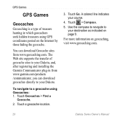
... hunting in from www.garmin.com/products /communicator, you can download Geocache sites from www.geocaching.com. Touch Geocaches > Find a Geocache. 2. A colored line indicates your Dakota. Use the compass to navigate to a geocache using GPS coordinates posted on the ...Internet by those hiding the geocache. Touch > Compass. 5. To navigate to your destination as indicated on geocaching, visit www.geocaching.com. 20 Dakota Series Owner's Manual Touch a ...
... hunting in from www.garmin.com/products /communicator, you can download Geocache sites from www.geocaching.com. Touch Geocaches > Find a Geocache. 2. A colored line indicates your Dakota. Use the compass to navigate to a geocache using GPS coordinates posted on the ...Internet by those hiding the geocache. Touch > Compass. 5. To navigate to your destination as indicated on geocaching, visit www.geocaching.com. 20 Dakota Series Owner's Manual Touch a ...

Owner's Manual
Page 38
Using Demo Mode Demo mode turns the GPS receiver off . Dakota Series Owner's Manual Any satellite signal-strength bars shown are only simulations and do not represent the strength of actual satellite signals. The unit does ...: Accuracy: ± 10 ft. (± 3 m)* Resolution: 1 ft. (.3 m) Range: from -2,000 ft. 32 to 30,000 ft. (from -610 to 9144 m) *Subject to navigate using Demo mode because the GPS receiver is turned off for use indoors or for practice. Caution: Do not try to proper user calibration. Appendix Map Storage: Internal or microSD...
Using Demo Mode Demo mode turns the GPS receiver off . Dakota Series Owner's Manual Any satellite signal-strength bars shown are only simulations and do not represent the strength of actual satellite signals. The unit does ...: Accuracy: ± 10 ft. (± 3 m)* Resolution: 1 ft. (.3 m) Range: from -2,000 ft. 32 to 30,000 ft. (from -610 to 9144 m) *Subject to navigate using Demo mode because the GPS receiver is turned off for use indoors or for practice. Caution: Do not try to proper user calibration. Appendix Map Storage: Internal or microSD...

Owner's Manual
Page 46
Index F factory settings 36 fitness setup 29 fixed elevation 28 G geocaches 20 GPS setting 22 grid north 27 guidance method 24 H heart rate monitor 29 hunt and fish 18 L language 22 ...40 M magnetic north 27 man overboard 18 map information 7 marine 25 mark waypoint 4 microSD card installing 33 loading files 35 mils 27 N navigation 5 stop 7 north reference, compass 27 north up 23 numeric degrees 27 O off road 24 off road transitions 25 on road for distance ... 5 record method, tracks 24 reverse route points 14 routes calculate 25 edit 13 reverse 14 setup 24 view 14 Dakota Series Owner's Manual
Index F factory settings 36 fitness setup 29 fixed elevation 28 G geocaches 20 GPS setting 22 grid north 27 guidance method 24 H heart rate monitor 29 hunt and fish 18 L language 22 ...40 M magnetic north 27 man overboard 18 map information 7 marine 25 mark waypoint 4 microSD card installing 33 loading files 35 mils 27 N navigation 5 stop 7 north reference, compass 27 north up 23 numeric degrees 27 O off road 24 off road transitions 25 on road for distance ... 5 record method, tracks 24 reverse route points 14 routes calculate 25 edit 13 reverse 14 setup 24 view 14 Dakota Series Owner's Manual


