Declaration of Conformity (Multilingual)
Page 1
... of Equipment: Model Number(s): Information Technology Equipment (Global Positioning System Receiver) DAKOTA 10 DAKOTA 20 The undersigned does hereby declare that the equipment complies with the above Directives Paul Morrow Quality Manager Garmin (Europe) Ltd. Type of measurement BS EN 60945: 2002 Maritime navigation and radio communication equipment and systems. General Requirements. Part 17: Specific conditions...
... of Equipment: Model Number(s): Information Technology Equipment (Global Positioning System Receiver) DAKOTA 10 DAKOTA 20 The undersigned does hereby declare that the equipment complies with the above Directives Paul Morrow Quality Manager Garmin (Europe) Ltd. Type of measurement BS EN 60945: 2002 Maritime navigation and radio communication equipment and systems. General Requirements. Part 17: Specific conditions...

Owner's Manual
Page 1
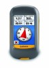
Dakota™ 10 and 20 owner's manual
Dakota™ 10 and 20 owner's manual

Owner's Manual
Page 5
GPS Games 20 Geocaches 20 Customizing the Dakota... 21 Changing the Profile 21 Setting Up Profiles 21 Using System Setup 22 Customizing the Display.......... 22 Map Setup 23 Track Setup 24 Customizing the ... Using Demo Mode 32 Connecting Your Dakota to a Computer........... 33 Installing a microSD™ Card 33 Transferring Tracks, Routes, or Waypoints 34 Loading and Deleting Files 35 Optimizing Battery Life 36 Restoring Factory Default Settings 36 Attaching a Carabiner, Lanyard, Mount, or Other Optional Accessory 37 Calibrating the Touchscreen 37 Software License Agreement 38...
GPS Games 20 Geocaches 20 Customizing the Dakota... 21 Changing the Profile 21 Setting Up Profiles 21 Using System Setup 22 Customizing the Display.......... 22 Map Setup 23 Track Setup 24 Customizing the ... Using Demo Mode 32 Connecting Your Dakota to a Computer........... 33 Installing a microSD™ Card 33 Transferring Tracks, Routes, or Waypoints 34 Loading and Deleting Files 35 Optimizing Battery Life 36 Restoring Factory Default Settings 36 Attaching a Carabiner, Lanyard, Mount, or Other Optional Accessory 37 Calibrating the Touchscreen 37 Software License Agreement 38...
Owner's Manual
Page 15
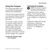
Basic Navigation Calibrating the Compass note: The electronic compass is similar to a magnetic compass when you maintain a higher speed, such as traveling in an automobile, the compass uses GPS signals to determine your destination by displaying a compass and a bearing pointer. The electronic compass is unavailable with the Dakota 10. Calibrate the compass after moving long...
Basic Navigation Calibrating the Compass note: The electronic compass is similar to a magnetic compass when you maintain a higher speed, such as traveling in an automobile, the compass uses GPS signals to determine your destination by displaying a compass and a bearing pointer. The electronic compass is unavailable with the Dakota 10. Calibrate the compass after moving long...
Owner's Manual
Page 26
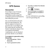
... You can download Geocache sites from www.garmin.com/products /communicator, you can download geocaches directly to your Dakota. Use the compass to navigate to a geocache using GPS coordinates posted on the Internet by those ...GPS Games GPS Games Geocaches Geocaching is a type of geocache sites to your Dakota, and, after registering and installing the Garmin Communicator plug-in which geocachers seek hidden treasures using Geocaches: 1. A colored line indicates your destination as indicated on geocaching, visit www.geocaching.com. 20 Dakota Series Owner's Manual To navigate...
... You can download Geocache sites from www.garmin.com/products /communicator, you can download geocaches directly to your Dakota. Use the compass to navigate to a geocache using GPS coordinates posted on the Internet by those ...GPS Games GPS Games Geocaches Geocaching is a type of geocache sites to your Dakota, and, after registering and installing the Garmin Communicator plug-in which geocachers seek hidden treasures using Geocaches: 1. A colored line indicates your destination as indicated on geocaching, visit www.geocaching.com. 20 Dakota Series Owner's Manual To navigate...

Owner's Manual
Page 37
... to 158°F (from 3 to 5 m) 95% typical (WAAS accuracy in . DGPS: From 10 to 16 ft. (from -15 to 100 m 2DRMS under the U.S. no memory battery required Dakota Series Owner's Manual 31 Appendix Appendix Specifications Physical Size: 3.9 in North America) Velocity: 0.328 ft...: 2.6 in . Power Source: Two AA batteries (alkaline, NiMH, or lithium) Battery Life: Up to 20 hours Accuracy GPS: < 33 ft. (10 m) 95% typical* *Subject to accuracy degradation to 70°C)* *The temperature rating of the Dakota may exceed the usable range of some batteries. H × 2.2 in.
... to 158°F (from 3 to 5 m) 95% typical (WAAS accuracy in . DGPS: From 10 to 16 ft. (from -15 to 100 m 2DRMS under the U.S. no memory battery required Dakota Series Owner's Manual 31 Appendix Appendix Specifications Physical Size: 3.9 in North America) Velocity: 0.328 ft...: 2.6 in . Power Source: Two AA batteries (alkaline, NiMH, or lithium) Battery Life: Up to 20 hours Accuracy GPS: < 33 ft. (10 m) 95% typical* *Subject to accuracy degradation to 70°C)* *The temperature rating of the Dakota may exceed the usable range of some batteries. H × 2.2 in.
Owner's Manual
Page 45
... barometer mode 28 battery 2 optimal battery type 36 replacing 2 bearing 27 C cadence sensor 29 calculator 17 calendar 17 calibration altimeter 29 compass 9 carabiner 37 Communicator Garmin 20 Index compass calibration 9 north reference 27 course 27 D data fields changing 8, 11, 16, 23 show or hide 8 default settings 36 demo mode 32 directional letters...
... barometer mode 28 battery 2 optimal battery type 36 replacing 2 bearing 27 C cadence sensor 29 calculator 17 calendar 17 calibration altimeter 29 compass 9 carabiner 37 Communicator Garmin 20 Index compass calibration 9 north reference 27 course 27 D data fields changing 8, 11, 16, 23 show or hide 8 default settings 36 demo mode 32 directional letters...

Owner's Manual
Page 46
Index F factory settings 36 fitness setup 29 fixed elevation 28 G geocaches 20 GPS setting 22 grid north 27 guidance method 24 H heart rate monitor 29 hunt and fish 18 L language 22 ...40 M magnetic north 27 man overboard 18 map information 7 marine 25 mark waypoint 4 microSD card installing 33 loading files 35 mils 27 N navigation 5 stop 7 north reference, compass 27 north up 23 numeric degrees 27 O off road 24 off road transitions 25 on road for distance ... 5 record method, tracks 24 reverse route points 14 routes calculate 25 edit 13 reverse 14 setup 24 view 14 Dakota Series Owner's Manual
Index F factory settings 36 fitness setup 29 fixed elevation 28 G geocaches 20 GPS setting 22 grid north 27 guidance method 24 H heart rate monitor 29 hunt and fish 18 L language 22 ...40 M magnetic north 27 man overboard 18 map information 7 marine 25 mark waypoint 4 microSD card installing 33 loading files 35 mils 27 N navigation 5 stop 7 north reference, compass 27 north up 23 numeric degrees 27 O off road 24 off road transitions 25 on road for distance ... 5 record method, tracks 24 reverse route points 14 routes calculate 25 edit 13 reverse 14 setup 24 view 14 Dakota Series Owner's Manual


