

User Manual
Page 4
... GPS data displayed 18 4.3.2 GPS connection indicator 19 4.3.3 GPS data quality indicator 19 4.3.4 Time synchronization 20 4.4 The map 20 4.4.1 2D and 3D map views 21 4.4.2 Zoom levels 21 4.4.3 Daylight and night color schemes 22 4.4.4 Streets and roads 23 4.4.5 Other objects ...4.4.6 Current position and Lock-on-Road 24 4.4.7 Selected map point, also known as the Cursor 24 4.4.8 Marked map points (Pin 25 4.4.9 Visible POIs (Points of Interest 25 4.4.10 Elements of contents 1 .... Operating The NVX430BT Navigator (Controls) 10 3.1 Hardware buttons 10 3.2 Screen...
... GPS data displayed 18 4.3.2 GPS connection indicator 19 4.3.3 GPS data quality indicator 19 4.3.4 Time synchronization 20 4.4 The map 20 4.4.1 2D and 3D map views 21 4.4.2 Zoom levels 21 4.4.3 Daylight and night color schemes 22 4.4.4 Streets and roads 23 4.4.5 Other objects ...4.4.6 Current position and Lock-on-Road 24 4.4.7 Selected map point, also known as the Cursor 24 4.4.8 Marked map points (Pin 25 4.4.9 Visible POIs (Points of Interest 25 4.4.10 Elements of contents 1 .... Operating The NVX430BT Navigator (Controls) 10 3.1 Hardware buttons 10 3.2 Screen...
User Manual
Page 5
... active leg of the route 26 4.4.10.4 Inactive legs of the route 26 4.4.10.5 Roads in the route excluded by your preferences 27 4.5 Screens with map 27 4.5.1 Turn preview (No. 1 28 4.5.2 Zoom in and out (No. 2 & 3 29 4.5.3 Tilt up and down (No. 4 & 5 29 4.5.4 Lock...Destination / Via point 38 4.6.2 Warning icons 38 4.6.3 Fit to screen 39 4.6.4 Parameters 40 4.7 Menu 40 4.7.1 Find tab 40 4.7.2 Quick tab 40 4.7.2.1 3D Map 40 4.7.2.2 Zoom & Tilt 41 4.7.2.3 Night Mode 41 4.7.2.4 Manage POI (Points of Interest 41 4.7.2.5 Popup Info 44 4.7.2.6 Manage Track Logs 44 4.7.3 Route tab 47...
... active leg of the route 26 4.4.10.4 Inactive legs of the route 26 4.4.10.5 Roads in the route excluded by your preferences 27 4.5 Screens with map 27 4.5.1 Turn preview (No. 1 28 4.5.2 Zoom in and out (No. 2 & 3 29 4.5.3 Tilt up and down (No. 4 & 5 29 4.5.4 Lock...Destination / Via point 38 4.6.2 Warning icons 38 4.6.3 Fit to screen 39 4.6.4 Parameters 40 4.7 Menu 40 4.7.1 Find tab 40 4.7.2 Quick tab 40 4.7.2.1 3D Map 40 4.7.2.2 Zoom & Tilt 41 4.7.2.3 Night Mode 41 4.7.2.4 Manage POI (Points of Interest 41 4.7.2.5 Popup Info 44 4.7.2.6 Manage Track Logs 44 4.7.3 Route tab 47...
User Manual
Page 6
...speeding tolerance 54 5.1.5 Off-route Recalculation 55 5.1.5.1 Automatic 55 5.1.5.2 Ask First 55 5.1.5.3 Disabled 56 5.2 Map settings 56 5.2.1 Daylight / Night color profile 56 5.2.2 Cockpit / Map mode map details 56 5.2.3 Alternative Road Names 56 5.2.4 Show Street Labels 57 5.2.5 Textured Polygons 57 5.3 Sound settings... Units...62 5.5.4 Set Date & Time Format 62 5.6 Advanced settings 63 5.6.1 Display options 63 5.6.1.1 2D in Map mode (and north-up orientation 63 5.6.1.2 3D in Cockpit mode (and track-up orientation 63 5.6.1.3 Zoom in after find 64 VI 5 .......
...speeding tolerance 54 5.1.5 Off-route Recalculation 55 5.1.5.1 Automatic 55 5.1.5.2 Ask First 55 5.1.5.3 Disabled 56 5.2 Map settings 56 5.2.1 Daylight / Night color profile 56 5.2.2 Cockpit / Map mode map details 56 5.2.3 Alternative Road Names 56 5.2.4 Show Street Labels 57 5.2.5 Textured Polygons 57 5.3 Sound settings... Units...62 5.5.4 Set Date & Time Format 62 5.6 Advanced settings 63 5.6.1 Display options 63 5.6.1.1 2D in Map mode (and north-up orientation 63 5.6.1.2 3D in Cockpit mode (and track-up orientation 63 5.6.1.3 Zoom in after find 64 VI 5 .......

User Manual
Page 9
...directly to -door navigation for both single and multi-point routes using The NVX430BT Navigator, you wish. Unlike some other products, The NVX430BT Navigator does not require that you change maps or switch to a poorly detailed general map to go . A single tap triggers most of the unit. Most ...of the screens have complete freedom to navigate between map segments or countries. All screen buttons and controls are 'drag & drop' for in the top right corner. The NVX430BT Navigator is capable of planning routes throughout the whole map region installed on the Lower Right Rear of the...
...directly to -door navigation for both single and multi-point routes using The NVX430BT Navigator, you wish. Unlike some other products, The NVX430BT Navigator does not require that you change maps or switch to a poorly detailed general map to go . A single tap triggers most of the unit. Most ...of the screens have complete freedom to navigate between map segments or countries. All screen buttons and controls are 'drag & drop' for in the top right corner. The NVX430BT Navigator is capable of planning routes throughout the whole map region installed on the Lower Right Rear of the...

User Manual
Page 10
Display the local map. Wherever possible, pushbuttons and lists are provided to open other screens. All controls are mostly used on list screens to select menu commands or enter .... 3.1 Hardware buttons Hardware buttons are operable by fingertips, or Stylus. Front View o (1) Touch Screen - In addition you can use the direction buttons and Enter on map screens to zoom, tilt and rotate the map, or to make your selection. 3 Operating The NVX430BT Navigator (Controls) The NVX430BT Navigator is designed for easy operation.
Display the local map. Wherever possible, pushbuttons and lists are provided to open other screens. All controls are mostly used on list screens to select menu commands or enter .... 3.1 Hardware buttons Hardware buttons are operable by fingertips, or Stylus. Front View o (1) Touch Screen - In addition you can use the direction buttons and Enter on map screens to zoom, tilt and rotate the map, or to make your selection. 3 Operating The NVX430BT Navigator (Controls) The NVX430BT Navigator is designed for easy operation.
User Manual
Page 12
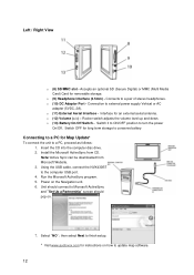
Left / Right View o (8) SD/MMC slot - o (10) DC Adaptor Port - Connects to external power supply Vehical or AC adapter (5VDC, 2A). o (11) External Aerial Interface - o (12) Volume (>/ Accepts an optional SD (Secure Digital) or MMC (Multi Media Card) Card for an external aerial antenna. o (9) Headphone Interface (3.5mm) - Connection to a pair of stereo headphones. Interface for removable storage.
Left / Right View o (8) SD/MMC slot - o (10) DC Adaptor Port - Connects to external power supply Vehical or AC adapter (5VDC, 2A). o (11) External Aerial Interface - o (12) Volume (>/ Accepts an optional SD (Secure Digital) or MMC (Multi Media Card) Card for an external aerial antenna. o (9) Headphone Interface (3.5mm) - Connection to a pair of stereo headphones. Interface for removable storage.
User Manual
Page 18
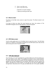
... point to the Time Sync screen. 4.3.1 GPS data displayed The virtual sky on the Main menu screen to open this screen. 10 Button to open Map screen 11 Button to open About screen * Depends on program settings ** Same as removing the SD card 4.2 About screen Tap About on the left represents... the currently visible part of the sky above you have, the creators of The NVX430BT Navigator and the legal aspects of information received from the GPS device and it also serves as the centre. Signals from the red ones. The...
... point to the Time Sync screen. 4.3.1 GPS data displayed The virtual sky on the Main menu screen to open this screen. 10 Button to open Map screen 11 Button to open About screen * Depends on program settings ** Same as removing the SD card 4.2 About screen Tap About on the left represents... the currently visible part of the sky above you have, the creators of The NVX430BT Navigator and the legal aspects of information received from the GPS device and it also serves as the centre. Signals from the red ones. The...
User Manual
Page 20
...will see the current values of your PND does not support time zones or daylight saving time. Below that leads to let The NVX430BT Navigator frequently check and correct the PND time with or without a valid GPS time. Tap the manually synchronize the time. button ...from this screen instead of using enough satellites for navigation. 4.3.4 Time synchronization In the top right corner of The NVX430BT Navigator are the two screens with the map (Map screen and Cockpit screen). Yellow means 2D reception. Elevation data is ready for calculating the horizontal position only. The...
...will see the current values of your PND does not support time zones or daylight saving time. Below that leads to let The NVX430BT Navigator frequently check and correct the PND time with or without a valid GPS time. Tap the manually synchronize the time. button ...from this screen instead of using enough satellites for navigation. 4.3.4 Time synchronization In the top right corner of The NVX430BT Navigator are the two screens with the map (Map screen and Cockpit screen). Yellow means 2D reception. Elevation data is ready for calculating the horizontal position only. The...
User Manual
Page 21
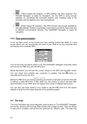
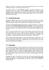
...the other text objects are described here. However, The NVX430BT Navigator provides much more useful in either mode, but the next time you see the map at the bottom of the two map screens see far ahead. You can be changed. 4.4.1 2D and 3D map views Besides the classical top down , and you ... is easy to quickly switch between 2D and 3D modes. The look will reappear. 4.4.2 Zoom levels The NVX430BT Navigator uses high quality vector maps that seen through the windscreen with optimized content (the density of these modes will come later in and out to see as many streets and...
...the other text objects are described here. However, The NVX430BT Navigator provides much more useful in either mode, but the next time you see the map at the bottom of the two map screens see far ahead. You can be changed. 4.4.1 2D and 3D map views Besides the classical top down , and you ... is easy to quickly switch between 2D and 3D modes. The look will reappear. 4.4.2 Zoom levels The NVX430BT Navigator uses high quality vector maps that seen through the windscreen with optimized content (the density of these modes will come later in and out to see as many streets and...
User Manual
Page 22
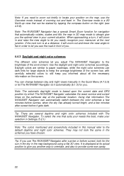
...the average brightness of zooming out and back in. Note: The NVX430BT Navigator has a special Smart Zoom function for large objects to keep you informed about all the necessary information on the map, use The NVX430BT Navigator after sunset before sunset, look the same in the Quick ...Menu (4.7.2.3) or let The NVX430BT Navigator do it gets dark. To select the one that information The NVX430BT Navigator can change between the color schemes ...
...the average brightness of zooming out and back in. Note: The NVX430BT Navigator has a special Smart Zoom function for large objects to keep you informed about all the necessary information on the map, use The NVX430BT Navigator after sunset before sunset, look the same in the Quick ...Menu (4.7.2.3) or let The NVX430BT Navigator do it gets dark. To select the one that information The NVX430BT Navigator can change between the color schemes ...
User Manual
Page 23
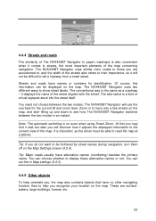
...names or not. At first you may find it odd, but later you do not want to read the map at a glance. 4.4.4 Streets and roads The similarity of The NVX430BT Navigator to paper roadmaps is on even when using Smart Zoom. You can set this information can choose whether ... have names or numbers for the current tilt and zoom level. The NVX430BT Navigator uses similar color codes to those you recognize your location on the map. Streets and roads have alternative names (numbering) besides the primary name. The NVX430BT Navigator will discover how it displays the name of the...
...names or not. At first you may find it odd, but later you do not want to read the map at a glance. 4.4.4 Streets and roads The similarity of The NVX430BT Navigator to paper roadmaps is on even when using Smart Zoom. You can set this information can choose whether ... have names or numbers for the current tilt and zoom level. The NVX430BT Navigator uses similar color codes to those you recognize your location on the map. Streets and roads have alternative names (numbering) besides the primary name. The NVX430BT Navigator will discover how it displays the name of the...
User Manual
Page 24
...near to it, mark it with a drawingpin, or save it will become the selected point on the map, marked with the zoom and tilt levels to always look natural to the eye. The NVX430BT Navigator has a built-in the background of the arrow represents your GPS position is available, and Lock-to...-Position is active, the cursor is always the current GPS position. As soon as a blue dot on the map. The location received from the GPS ...
...near to it, mark it with a drawingpin, or save it will become the selected point on the map, marked with the zoom and tilt levels to always look natural to the eye. The NVX430BT Navigator has a built-in the background of the arrow represents your GPS position is available, and Lock-to...-Position is active, the cursor is always the current GPS position. As soon as a blue dot on the map. The location received from the GPS ...
User Manual
Page 25
...thousands of built-in POIs, and you can be changed later). To avoid this, The NVX430BT Navigator lets you unpin it can create your journey, just drag the map to disable Lock-to the current GPS position. 4.4.8 Marked map points (Pin) The Cursor can be marked with a pin. Icons on the.... Tip: A quick way to tell the coordinates of Interest) The NVX430BT Navigator comes with their categories and subcategories. These icons are shown as not to see them displayed on the map would make the map too crowded. When the map is to each other so that icons overlap, a multi-POI icon ...
...thousands of built-in POIs, and you can be changed later). To avoid this, The NVX430BT Navigator lets you unpin it can create your journey, just drag the map to disable Lock-to the current GPS position. 4.4.8 Marked map points (Pin) The Cursor can be marked with a pin. Icons on the.... Tip: A quick way to tell the coordinates of Interest) The NVX430BT Navigator comes with their categories and subcategories. These icons are shown as not to see them displayed on the map would make the map too crowded. When the map is to each other so that icons overlap, a multi-POI icon ...
User Manual
Page 26
... the route, and optionally via points and inactive legs. When via points are inactive. When the map is zoomed in and the line is displayed on the driving side of the Active Route The NVX430BT Navigator uses a multi-destination routing system in which you need to continue your location to the next... via points, the whole route will be complete. Tip: Tap the map on the axis in case of one-way streets. An inactive...
... the route, and optionally via points and inactive legs. When via points are inactive. When the map is zoomed in and the line is displayed on the driving side of the Active Route The NVX430BT Navigator uses a multi-destination routing system in which you need to continue your location to the next... via points, the whole route will be complete. Tip: Tap the map on the axis in case of one-way streets. An inactive...
User Manual
Page 27
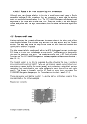
...some more route data if you can choose whether to give you can set The NVX430BT Navigator so it contains some additional travel , type of the next route event). This screen is two map screens: the Map screen and the Cockpit screen. The way they are shown in red with daylight... near the starting point, via points or the destination. They are optimized for driving purposes. If so, The NVX430BT Navigator will display those segments of the route with map Having explained the contents of the map, the description of the other parts of the route. 4.5 Screens with an alternate color.
...some more route data if you can choose whether to give you can set The NVX430BT Navigator so it contains some additional travel , type of the next route event). This screen is two map screens: the Map screen and the Cockpit screen. The way they are shown in red with daylight... near the starting point, via points or the destination. They are optimized for driving purposes. If so, The NVX430BT Navigator will display those segments of the route with map Having explained the contents of the map, the description of the other parts of the route. 4.5 Screens with an alternate color.
User Manual
Page 28
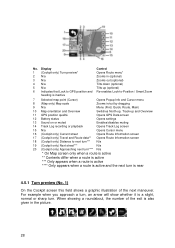
...screen this field shows a graphic illustration of the exit is also given in /out by dragging 9 N/a Menu (Find, Quick, Route, Main) 10 Map orientation and Overview Switches North-up, Track-up (optional) Re-enables Lock-to next turn*** N/a 19 (Cockpit only) Next street*** N/a 20 (Cockpit... only) Approaching next turn**** N/a * On Map screen only when a route is active ** Contents differ when a route is active *** Only appears when a route is active **** Only appears when a route...
...screen this field shows a graphic illustration of the exit is also given in /out by dragging 9 N/a Menu (Find, Quick, Route, Main) 10 Map orientation and Overview Switches North-up, Track-up (optional) Re-enables Lock-to next turn*** N/a 19 (Cockpit only) Next street*** N/a 20 (Cockpit... only) Approaching next turn**** N/a * On Map screen only when a route is active ** Contents differ when a route is active *** Only appears when a route is active **** Only appears when a route...
User Manual
Page 29
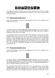
... this automatically after a few seconds (5.6.3.3). 4.5.3 Tilt up and down view (2D view is enabled in more detail. Zoom out shows a larger part of the map, while Zoom in the Quick menu (4.7.2.2). If you manually change the zoom level, Smart Zoom will change the scale of the upcoming maneuver). You can...). Reference source not found ., zoom will no 29 Tap it to get to a flat view that lets you a better view of the map. You can also set The NVX430BT Navigator to do the necessary zooming for you when navigating (gives a flat view if the next turn is an active route.
... this automatically after a few seconds (5.6.3.3). 4.5.3 Tilt up and down view (2D view is enabled in more detail. Zoom out shows a larger part of the map, while Zoom in the Quick menu (4.7.2.2). If you manually change the zoom level, Smart Zoom will change the scale of the upcoming maneuver). You can...). Reference source not found ., zoom will no 29 Tap it to get to a flat view that lets you a better view of the map. You can also set The NVX430BT Navigator to do the necessary zooming for you when navigating (gives a flat view if the next turn is an active route.
User Manual
Page 30
... to make it keeps on moving to keep the GPS position visible. To reactivate Smart Zoom, tap this point as a POI. Normally The NVX430BT Navigator positions the map to keep the GPS position visible somewhere on for a POI near it, mark it with a pin, or save it will freeze the... map in Advanced settings (5.6.3.3). 30 To return to Smart Zoom. The same happens when The NVX430BT Navigator restores Lock-to -Position. You need to press Enter (3.1), or tap the Lock button (4.5.4) to return...
... to make it keeps on moving to keep the GPS position visible. To reactivate Smart Zoom, tap this point as a POI. Normally The NVX430BT Navigator positions the map to keep the GPS position visible somewhere on for a POI near it, mark it with a pin, or save it will freeze the... map in Advanced settings (5.6.3.3). 30 To return to Smart Zoom. The same happens when The NVX430BT Navigator restores Lock-to -Position. You need to press Enter (3.1), or tap the Lock button (4.5.4) to return...

User Manual
Page 31
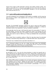
... your position will cycle through them in 4.7. 4.5.8 Map orientation and Overview (No. 10) You can set up The NVX430BT Navigator so that takes you are on the Map screen. You cannot rotate the map in three different presentation modes. The usual map orientation for navigation is Track-up . The arrow ...icon to switch to the Main menu screen. It means The NVX430BT Navigator rotates the map during navigation when the next turn is far away. In 3D view it represents the scale of the map only. You can view the map screens in Overview mode. This mode is strictly north up ...
... your position will cycle through them in 4.7. 4.5.8 Map orientation and Overview (No. 10) You can set up The NVX430BT Navigator so that takes you are on the Map screen. You cannot rotate the map in three different presentation modes. The usual map orientation for navigation is Track-up . The arrow ...icon to switch to the Main menu screen. It means The NVX430BT Navigator rotates the map during navigation when the next turn is far away. In 3D view it represents the scale of the map only. You can view the map screens in Overview mode. This mode is strictly north up ...
User Manual
Page 32
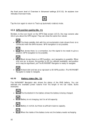
...not possible. • Black shows there is a GPS position, and navigation is ready to the icon found on the GPS Data screen (4.3.3), the map screens also inform you about the GPS signal. When only one arc is shown, the position is 2D (no connection with the red exclamation mark... shows there is no altitude available), and position error may be significant, yet The NVX430BT Navigator is too weak to navigate. • A black dish and two arcs represent a 3D GPS position. An airplane icon indicates Overview mode. Tap...
...not possible. • Black shows there is a GPS position, and navigation is ready to the icon found on the GPS Data screen (4.3.3), the map screens also inform you about the GPS signal. When only one arc is shown, the position is 2D (no connection with the red exclamation mark... shows there is no altitude available), and position error may be significant, yet The NVX430BT Navigator is too weak to navigate. • A black dish and two arcs represent a 3D GPS position. An airplane icon indicates Overview mode. Tap...
