

User Manual
Page 4
... keyboard 16 4 .... Warnings and safety information 8 2 .... Table of the Active Route 26 4.4.10.1 The start point, via points and the destination 26 4.4.10.2 Animated turn guidance 26 IV Discovering the program through the screens 17 4.1 Main menu 17 4.2 About screen 18 4.3 GPS Data screen 18 4.3.1 GPS data displayed 18 4.3.2 GPS connection indicator 19 4.3.3 GPS data quality indicator 19 4.3.4 Time synchronization 20 4.4 The map 20 4.4.1 2D and 3D map views 21 4.4.2 Zoom levels...
... keyboard 16 4 .... Warnings and safety information 8 2 .... Table of the Active Route 26 4.4.10.1 The start point, via points and the destination 26 4.4.10.2 Animated turn guidance 26 IV Discovering the program through the screens 17 4.1 Main menu 17 4.2 About screen 18 4.3 GPS Data screen 18 4.3.1 GPS data displayed 18 4.3.2 GPS connection indicator 19 4.3.3 GPS data quality indicator 19 4.3.4 Time synchronization 20 4.4 The map 20 4.4.1 2D and 3D map views 21 4.4.2 Zoom levels...
User Manual
Page 7
... 66 5.6.4 Route options 67 5.6.4.1 Off-route sensitivity and Recalculation delay 68 5.6.4.2 U-turn penalty 68 5.6.4.3 Cross-border planning 68 5.6.4.4 Keep position on road (Lock-on-Road 68 5.6.5 User data management 69 5.6.5.1 Backup Data 69 5.6.5.2 Restore Data 69 5.6.5.3 Remove Pins 70 5.6.5.4 Clear Data 70 5.6.5.5 Reset Advanced Settings 70 6 .... 5.6.1.4 Coordinate display format 64 5.6.1.5 Cockpit layout 64 5.6.2 Backlight settings 64 5.6.2.1 Power management 65 5.6.2.2 Brightness 65 5.6.3 Smart Zoom 65 5.6.3.1 Smart Zoom settings 66 5.6.3.2 Enable Overview mode 66...
... 66 5.6.4 Route options 67 5.6.4.1 Off-route sensitivity and Recalculation delay 68 5.6.4.2 U-turn penalty 68 5.6.4.3 Cross-border planning 68 5.6.4.4 Keep position on road (Lock-on-Road 68 5.6.5 User data management 69 5.6.5.1 Backup Data 69 5.6.5.2 Restore Data 69 5.6.5.3 Remove Pins 70 5.6.5.4 Clear Data 70 5.6.5.5 Reset Advanced Settings 70 6 .... 5.6.1.4 Coordinate display format 64 5.6.1.5 Cockpit layout 64 5.6.2 Backlight settings 64 5.6.2.1 Power management 65 5.6.2.2 Brightness 65 5.6.3 Smart Zoom 65 5.6.3.1 Smart Zoom settings 66 5.6.3.2 Enable Overview mode 66...
User Manual
Page 8
... need to change route parameters. Plan your exact location with the help of the vehicle, we strongly encourage you to turn on the road. If you are the driver of an attached GPS device. 1 Warnings and safety information The NVX430BT Navigator is a navigation system that helps you find your way to your journey. Never place the NVX430BT where it can cause injuries in (optional) Safety Mode...
... need to change route parameters. Plan your exact location with the help of the vehicle, we strongly encourage you to turn on the road. If you are the driver of an attached GPS device. 1 Warnings and safety information The NVX430BT Navigator is a navigation system that helps you find your way to your journey. Never place the NVX430BT where it can cause injuries in (optional) Safety Mode...

User Manual
Page 9
... products, The NVX430BT Navigator does not require that you change maps or switch to a poorly detailed general map to navigate between map segments or countries. You always have complete freedom to go . When using adaptable route parameters. 2 General information To Enter a Destination address refer to item 6 (Find) in this manual for detailed instruction The NVX430BT Navigator is a navigation system optimized for in Map mode (4.5.6). Just insert the memory card and go...
... products, The NVX430BT Navigator does not require that you change maps or switch to a poorly detailed general map to navigate between map segments or countries. You always have complete freedom to go . When using adaptable route parameters. 2 General information To Enter a Destination address refer to item 6 (Find) in this manual for detailed instruction The NVX430BT Navigator is a navigation system optimized for in Map mode (4.5.6). Just insert the memory card and go...

User Manual
Page 10
... changing settings as easy as possible. 3.1 Hardware buttons Hardware buttons are operable by fingertips, or Stylus. All controls are mostly used on list screens to make your selection. Tap the screen with the stylus to open other screens. In addition you can use the direction buttons and Enter on map screens to zoom, tilt and rotate the map, or to select menu commands or enter information. 10 Front View o (1) Touch Screen - Display the local map. 3 Operating...
... changing settings as easy as possible. 3.1 Hardware buttons Hardware buttons are operable by fingertips, or Stylus. All controls are mostly used on list screens to make your selection. Tap the screen with the stylus to open other screens. In addition you can use the direction buttons and Enter on map screens to zoom, tilt and rotate the map, or to select menu commands or enter information. 10 Front View o (1) Touch Screen - Display the local map. 3 Operating...
User Manual
Page 12
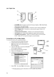
o (10) DC Adaptor Port - Connection to a pair of stereo headphones. Left / Right View o (8) SD/MMC slot - Interface for removable storage. o (11) External Aerial Interface - o (9) Headphone Interface (3.5mm) - Connects to external power supply Vehical or AC adapter (5VDC, 2A). Accepts an optional SD (Secure Digital) or MMC (Multi Media Card) Card for an external aerial antenna. o (12) Volume (>/
o (10) DC Adaptor Port - Connection to a pair of stereo headphones. Left / Right View o (8) SD/MMC slot - Interface for removable storage. o (11) External Aerial Interface - o (9) Headphone Interface (3.5mm) - Connects to external power supply Vehical or AC adapter (5VDC, 2A). Accepts an optional SD (Secure Digital) or MMC (Multi Media Card) Card for an external aerial antenna. o (12) Volume (>/
User Manual
Page 19
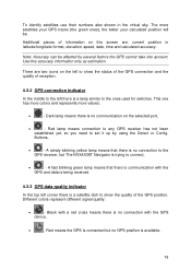
... numbers also shown in latitude/longitude format, elevation, speed, date, time and calculated accuracy. Use this screen are two icons on the left to show the quality of information on the selected port, • - Buttons, • - Different colors represent different signal quality: • - The more values: • - Additional pieces of the GPS position. This one has more colors and represents more satellites your GPS tracks...
... numbers also shown in latitude/longitude format, elevation, speed, date, time and calculated accuracy. Use this screen are two icons on the left to show the quality of information on the selected port, • - Buttons, • - Different colors represent different signal quality: • - The more values: • - Additional pieces of the GPS position. This one has more colors and represents more satellites your GPS tracks...
User Manual
Page 20
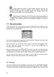
... using enough satellites for calculating the horizontal position only. Turn on the Auto Correction switch to a new screen where you the chance to calculate altitude. The map they 20 Elevation data is needed. You can also use these buttons if you prefer to the very accurate time provided by the connected GPS. It also gives you can still be significant. • - Tap the manually synchronize the time. The NVX430BT Navigator...
... using enough satellites for calculating the horizontal position only. Turn on the Auto Correction switch to a new screen where you the chance to calculate altitude. The map they 20 Elevation data is needed. You can also use these buttons if you prefer to the very accurate time provided by the connected GPS. It also gives you can still be significant. • - Tap the manually synchronize the time. The NVX430BT Navigator...
User Manual
Page 21
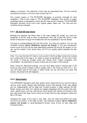
... special functions of the Map screen, use the switch in the Quick menu (4.7.2.1) to quickly switch between 2D and 3D modes. However, The NVX430BT Navigator provides much more useful in North-up Cockpit mode with the possibility to find that let you see the map at the bottom of the two map screens see how the map changes in either mode, but the next time you enter this manual. Reference source not found .) or...
... special functions of the Map screen, use the switch in the Quick menu (4.7.2.1) to quickly switch between 2D and 3D modes. However, The NVX430BT Navigator provides much more useful in North-up Cockpit mode with the possibility to find that let you see the map at the bottom of the two map screens see how the map changes in either mode, but the next time you enter this manual. Reference source not found .) or...
User Manual
Page 22
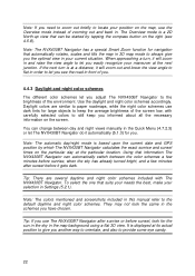
... out and lower the view angle to flat in this manual refer to locate your position on the map, use dark tints for navigation that can change between the color schemes a few minutes before sunrise, when the sky has already turned bright, and a few minutes after sunrise or before it gets dark. Note: The automatic day/night mode is displayed at the next...
... out and lower the view angle to flat in this manual refer to locate your position on the map, use dark tints for navigation that can change between the color schemes a few minutes before sunrise, when the sky has already turned bright, and a few minutes after sunrise or before it gets dark. Note: The automatic day/night mode is displayed at the next...
User Manual
Page 23
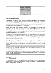
...will discover how it adjusts the displayed information to the current view of virtual signpost stuck into the street itself. The NVX430BT Navigator uses two different ways to see how The NVX430BT Navigator switches between the two modes. Zoom in Map settings (5.2.3). 4.4.5 Other ...NVX430BT Navigator uses similar color codes to those you , the map also contains objects that have names or numbers for the current tilt and zoom level. Tip: If you recognize your location on the Map Settings screen (5.2.4). Streets and roads have no other navigating function than to display...
...will discover how it adjusts the displayed information to the current view of virtual signpost stuck into the street itself. The NVX430BT Navigator uses two different ways to see how The NVX430BT Navigator switches between the two modes. Zoom in Map settings (5.2.3). 4.4.5 Other ...NVX430BT Navigator uses similar color codes to those you , the map also contains objects that have names or numbers for the current tilt and zoom level. Tip: If you recognize your location on the Map Settings screen (5.2.4). Streets and roads have no other navigating function than to display...
User Manual
Page 26
... you to the screen of a route are currently driving. When the map is the most conspicuous part of the map even when in the background of the route. To see the details of the route you need to continue your location to the next via point. These arrows show the direction of a 3D map view. The active section is displayed in light green...
... you to the screen of a route are currently driving. When the map is the most conspicuous part of the map even when in the background of the route. To see the details of the route you need to continue your location to the next via point. These arrows show the direction of a 3D map view. The active section is displayed in light green...
User Manual
Page 46
... more. o Enable auto-saving: when auto-saving is not needed any . Be careful when saving native GPS data, as it is enabled, you do not need to turn track log saving on the SD card, and they cannot be saved. These logs are saved as GPS position is capable of working with GPS devices using the previous switch. They are kept. • Replay: push this button to see a simulation of these formats. The NVX430BT Navigator will be...
... more. o Enable auto-saving: when auto-saving is not needed any . Be careful when saving native GPS data, as it is enabled, you do not need to turn track log saving on the SD card, and they cannot be saved. These logs are saved as GPS position is capable of working with GPS devices using the previous switch. They are kept. • Replay: push this button to see a simulation of these formats. The NVX430BT Navigator will be...
User Manual
Page 47
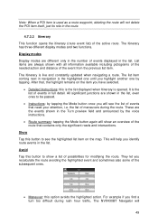
... based on a road parallel to that the manual route recalculation is set in the program. 4.7.3.1 Recalculate This menu point is only available if an active route exists and GPS position is also the button you will most frequently use when the window appears automatically, provided that recommended by the route. This is present. For example, you may have already almost reached...
... based on a road parallel to that the manual route recalculation is set in the program. 4.7.3.1 Recalculate This menu point is only available if an active route exists and GPS position is also the button you will most frequently use when the window appears automatically, provided that recommended by the route. This is present. For example, you may have already almost reached...
User Manual
Page 49
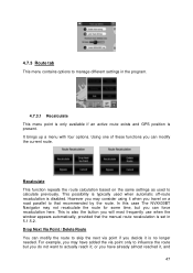
... is used as a route waypoint, deleting the route will show a list of possibilities for modifying the route. They let you identify route events in the list, even ones to see the list of the route that , the highlight remains on the map. The Itinerary has three different display modes and two functions. the list of maneuvers during rush hour traffic, The NVX430BT Navigator will...
... is used as a route waypoint, deleting the route will show a list of possibilities for modifying the route. They let you identify route events in the list, even ones to see the list of the route that , the highlight remains on the map. The Itinerary has three different display modes and two functions. the list of maneuvers during rush hour traffic, The NVX430BT Navigator will...
User Manual
Page 50
... the map from later routes until you find some distance buttons in the route), and voice instructions are also played. There are similar to the ones in your route, or a roadblock is announced on the screen to stop the simulation. Fast Fly Over Tap Fly Over to quickly run into a roadblock or traffic jam. The NVX430BT Navigator is to press and hold the first hardware button...
... the map from later routes until you find some distance buttons in the route), and voice instructions are also played. There are similar to the ones in your route, or a roadblock is announced on the screen to stop the simulation. Fast Fly Over Tap Fly Over to quickly run into a roadblock or traffic jam. The NVX430BT Navigator is to press and hold the first hardware button...
User Manual
Page 57
... names and POI icons if The NVX430BT Navigator follows your position. Press Enter or tap Lock to re-enable Lock-to recognize your location on the map, if you turn them will change the status of your PND settings. When you exit the program, the device settings return. As soon as a mute button. If you move the map and Lock-to mute all The NVX430BT Navigator sounds.
... names and POI icons if The NVX430BT Navigator follows your position. Press Enter or tap Lock to re-enable Lock-to recognize your location on the map, if you turn them will change the status of your PND settings. When you exit the program, the device settings return. As soon as a mute button. If you move the map and Lock-to mute all The NVX430BT Navigator sounds.

User Manual
Page 60
... prohibition. In this case a warning icon will be shown on the Route Information screen (4.6), and the road not matching your preference will be displayed in a bad condition and you usually cannot reach the speed limit on the map. 5.4.4.1 Unpaved Roads Unpaved roads are to be taken into account (e.g. If your needs you can also set which road types are...
... prohibition. In this case a warning icon will be shown on the Route Information screen (4.6), and the road not matching your preference will be displayed in a bad condition and you usually cannot reach the speed limit on the map. 5.4.4.1 Unpaved Roads Unpaved roads are to be taken into account (e.g. If your needs you can also set which road types are...
User Manual
Page 69
... , make a backup, remove the card, insert it to the latest backup. 69 The backup is put into the other PND, let the automatic setup run, then return to copy all position errors and position fluctuations. 5.6.5 User data management Everything that was saved (pins, My POIs, Favorites, track logs etc.) or modified (Settings, History lists) since The NVX430BT Navigator was installed is stored in a user database located in the...
... , make a backup, remove the card, insert it to the latest backup. 69 The backup is put into the other PND, let the automatic setup run, then return to copy all position errors and position fluctuations. 5.6.5 User data management Everything that was saved (pins, My POIs, Favorites, track logs etc.) or modified (Settings, History lists) since The NVX430BT Navigator was installed is stored in a user database located in the...

User Manual
Page 70
... changes made since the time of the latest backup. However, if you enter the Find system using the Find & GO button, The NVX430BT Navigator will immediately put you will warn you have several possible actions (set as start, set as destination, add as a POI item). The NVX430BT Navigator will lose all user data. It is selecting the destination. By tapping this button you into Cockpit mode and start navigation...
... changes made since the time of the latest backup. However, if you enter the Find system using the Find & GO button, The NVX430BT Navigator will immediately put you will warn you have several possible actions (set as start, set as destination, add as a POI item). The NVX430BT Navigator will lose all user data. It is selecting the destination. By tapping this button you into Cockpit mode and start navigation...


