
User Manual
Page 1
User Manual GPS navigation software for Audiovox NVX430BT English Owners manual :128-8226 VER : 00
User Manual GPS navigation software for Audiovox NVX430BT English Owners manual :128-8226 VER : 00

User Manual
Page 4
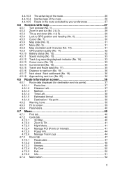
Operating The NVX430BT Navigator (Controls) 10 3.1 Hardware buttons 10 3.2 Screen buttons and controls 12 3.2.1 Direct selectors 13 3.2.2 List selectors 13 3.2.3 Sliders 13 3.2.4 Switches 14 3.2.5 Special switches...26 4.4.10.2 Animated turn guidance 26 IV Discovering the program through the screens 17 4.1 Main menu 17 4.2 About screen 18 4.3 GPS Data screen 18 4.3.1 GPS data displayed 18 4.3.2 GPS connection indicator 19 4.3.3 GPS data quality indicator 19 4.3.4 Time synchronization 20 4.4 The map 20 4.4.1 2D and 3D map views 21 4.4.2 Zoom levels 21 ...
Operating The NVX430BT Navigator (Controls) 10 3.1 Hardware buttons 10 3.2 Screen buttons and controls 12 3.2.1 Direct selectors 13 3.2.2 List selectors 13 3.2.3 Sliders 13 3.2.4 Switches 14 3.2.5 Special switches...26 4.4.10.2 Animated turn guidance 26 IV Discovering the program through the screens 17 4.1 Main menu 17 4.2 About screen 18 4.3 GPS Data screen 18 4.3.1 GPS data displayed 18 4.3.2 GPS connection indicator 19 4.3.3 GPS data quality indicator 19 4.3.4 Time synchronization 20 4.4 The map 20 4.4.1 2D and 3D map views 21 4.4.2 Zoom levels 21 ...
User Manual
Page 5
... 27 4.5 Screens with map 27 4.5.1 Turn preview (No. 1 28 4.5.2 Zoom in and out (No. 2 & 3 29 4.5.3 Tilt up and down (No. 4 & 5 29 4.5.4 Lock to GPS position and heading (No. 6 30 4.5.5 Cursor (No. 7 30 4.5.6 Map scale (No. 8 31 4.5.7 Menu (No. 9 31 4.5.8 Map orientation and Overview (No. 10 31... 4.5.9 GPS position quality (No. 11 32 4.5.10 Battery status (No. 12 32 4.5.11 Sound muting (No. 13 33 4.5.12 Track Log recording/playback indicator (No. 14 ...
... 27 4.5 Screens with map 27 4.5.1 Turn preview (No. 1 28 4.5.2 Zoom in and out (No. 2 & 3 29 4.5.3 Tilt up and down (No. 4 & 5 29 4.5.4 Lock to GPS position and heading (No. 6 30 4.5.5 Cursor (No. 7 30 4.5.6 Map scale (No. 8 31 4.5.7 Menu (No. 9 31 4.5.8 Map orientation and Overview (No. 10 31... 4.5.9 GPS position quality (No. 11 32 4.5.10 Battery status (No. 12 32 4.5.11 Sound muting (No. 13 33 4.5.12 Track Log recording/playback indicator (No. 14 ...
User Manual
Page 8
... the road. The position information obtained from the GPS receiver will not be the only one to operate The NVX430BT Navigator, we recommend that you operate The NVX430BT Navigator before beginning your route before you obey any instruction from The NVX430BT Navigator. It is also important that you look...deployment zone of airbags, or where it can obstruct the view of an attached GPS device. You should be able to track you. Plan your journey. If you need to change route parameters. The NVX430BT Navigator has a built-in (optional) Safety Mode that will determine your exact ...
... the road. The position information obtained from the GPS receiver will not be the only one to operate The NVX430BT Navigator, we recommend that you operate The NVX430BT Navigator before beginning your route before you obey any instruction from The NVX430BT Navigator. It is also important that you look...deployment zone of airbags, or where it can obstruct the view of an attached GPS device. You should be able to track you. Plan your journey. If you need to change route parameters. The NVX430BT Navigator has a built-in (optional) Safety Mode that will determine your exact ...
User Manual
Page 17
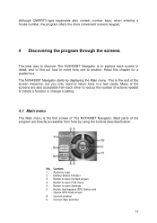
...need to return here in detail, and to find out how to move from here by displaying the Main menu. Most parts of The NVX430BT Navigator. No. Content 1 Audiovox logo 2 Battery Status indicator 3 Button to open Cockpit screen 4 Button to open Find menu 5 Button to another. Many of the...open Settings 6 Button that displays GPS Status and Opens GPS Data screen 8 Current position 9 Current date and time 17 Read this chapter for a guided tour. This is the first screen of the program are also accessible from each screen in a few cases. The NVX430BT Navigator starts by using the ...
...need to return here in detail, and to find out how to move from here by displaying the Main menu. Most parts of The NVX430BT Navigator. No. Content 1 Audiovox logo 2 Battery Status indicator 3 Button to open Cockpit screen 4 Button to open Find menu 5 Button to another. Many of the...open Settings 6 Button that displays GPS Status and Opens GPS Data screen 8 Current position 9 Current date and time 17 Read this chapter for a guided tour. This is the first screen of the program are also accessible from each screen in a few cases. The NVX430BT Navigator starts by using the ...
User Manual
Page 18
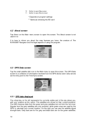
... grey satellites but not from the GPS device and it also serves as the centre. Signals from the grey satellites are only received, while green ones are used in no It is here to inform you about the map licenses you have, the creators of The NVX430BT Navigator and the legal aspects... of using the program. 4.3 GPS Data screen Tap the small satellite dish icon in the Main menu to calculate your position as the entry point to...
... grey satellites but not from the GPS device and it also serves as the centre. Signals from the grey satellites are only received, while green ones are used in no It is here to inform you about the map licenses you have, the creators of The NVX430BT Navigator and the legal aspects... of using the program. 4.3 GPS Data screen Tap the small satellite dish icon in the Main menu to calculate your position as the entry point to...
User Manual
Page 19
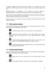
... current position in the virtual sky. Black with a red cross means there is no GPS position is a satellite dish to show the status of the GPS connection and the quality of reception. 4.3.2 GPS connection indicator In the middle to the left to connect, • - This one has... green ones), the better your calculated position will be affected by using the Detect or Config. Red means the GPS is connected but The NVX430BT Navigator is communication with the GPS device, • - Note: Accuracy can be . To identify satellites use their numbers also shown in latitude/...
... current position in the virtual sky. Black with a red cross means there is no GPS position is a satellite dish to show the status of the GPS connection and the quality of reception. 4.3.2 GPS connection indicator In the middle to the left to connect, • - This one has... green ones), the better your calculated position will be affected by using the Detect or Config. Red means the GPS is connected but The NVX430BT Navigator is communication with the GPS device, • - Note: Accuracy can be . To identify satellites use their numbers also shown in latitude/...
User Manual
Page 20
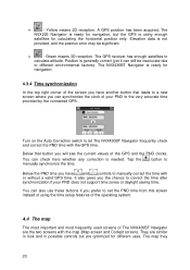
... any correction is ready for navigation, but are the two screens with the GPS time. The NVX430BT Navigator is needed. It also gives you prefer to manually correct the time with or without a valid GPS time. Elevation data is generally correct (yet it can also use these buttons... time after synchronization if your PND to the very accurate time provided by the connected GPS. You can synchronize the clock of the screen you will see the current values of The NVX430BT Navigator are optimized for calculating the horizontal position only. Position is not provided, and ...
... any correction is ready for navigation, but are the two screens with the GPS time. The NVX430BT Navigator is needed. It also gives you prefer to manually correct the time with or without a valid GPS time. Elevation data is generally correct (yet it can also use these buttons... time after synchronization if your PND to the very accurate time provided by the connected GPS. You can synchronize the clock of the screen you will see the current values of The NVX430BT Navigator are optimized for calculating the horizontal position only. Position is not provided, and ...
User Manual
Page 22
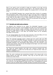
... your current situation. When approaching a turn is based upon the current date and GPS position by tapping the compass button on the right (see the road in order to let you see 4.5.8). Note: The NVX430BT Navigator has a special Smart Zoom function for large objects to keep the average brightness... lower the view angle to flat in front of you. 4.4.3 Daylight and night color schemes The different color schemes let you adjust The NVX430BT Navigator to the brightness of zooming out and back in the schemes you have chosen. Use the daylight and night color schemes accordingly. Note...
... your current situation. When approaching a turn is based upon the current date and GPS position by tapping the compass button on the right (see the road in order to let you see 4.5.8). Note: The NVX430BT Navigator has a special Smart Zoom function for large objects to keep the average brightness... lower the view angle to flat in front of you. 4.4.3 Daylight and night color schemes The different color schemes let you adjust The NVX430BT Navigator to the brightness of zooming out and back in the schemes you have chosen. Use the daylight and night color schemes accordingly. Note...
User Manual
Page 24
...If you drive (e.g. Note: the Lock-on two-way roads. The direction of the arrow represents your GPS position is available, and Lock-to -Position becomes disabled, and the Lock button appears on the map. ...You can use . on the right in Germany and on the left in the track log (4.7.2.6). When the GPS position is lost, the arrow turns grey and jumps to the last known position, disabling Lock-on-Road (...item in case of one-way streets, or on the side of a 3D map view. The NVX430BT Navigator has a built-in Lock-on-Road feature that Lock-on the map, marked with active Lock-on...
...If you drive (e.g. Note: the Lock-on two-way roads. The direction of the arrow represents your GPS position is available, and Lock-to -Position becomes disabled, and the Lock button appears on the map. ...You can use . on the right in Germany and on the left in the track log (4.7.2.6). When the GPS position is lost, the arrow turns grey and jumps to the last known position, disabling Lock-on-Road (...item in case of one-way streets, or on the side of a 3D map view. The NVX430BT Navigator has a built-in Lock-on-Road feature that Lock-on the map, marked with active Lock-on...
User Manual
Page 25
...enough to recognize the symbol, and semi-transparent so as not to -Position (4.5.4). If you found on the map is shown instead of Interest) The NVX430BT Navigator comes with their categories and subcategories. Different colors help you also save the coordinates with a pin. Tip: A quick way to tell the coordinates...icon will restore street names and POI icons immediately. Icons on the map would make the map too crowded. Zoom in more to the current GPS position. 4.4.8 Marked map points (Pin) The Cursor can be marked with the pin for the coordinates in POI it is visible at the ...
...enough to recognize the symbol, and semi-transparent so as not to -Position (4.5.4). If you found on the map is shown instead of Interest) The NVX430BT Navigator comes with their categories and subcategories. Different colors help you also save the coordinates with a pin. Tip: A quick way to tell the coordinates...icon will restore street names and POI icons immediately. Icons on the map would make the map too crowded. Zoom in more to the current GPS position. 4.4.8 Marked map points (Pin) The Cursor can be marked with the pin for the coordinates in POI it is visible at the ...
User Manual
Page 26
..., tap the blue 'i' icon on the right. An inactive route section becomes active as soon as a route point. 4.4.10 Elements of the Active Route The NVX430BT Navigator uses a multi-destination routing system in red during the night. The line of the route is displayed on the driving side of the road... it is the most conspicuous part of the map even when in a popup list, if it is the part leading from your current location if GPS position is a button called POI that leads you to the screen of all nearby POI items. There you reach its starting the journey or when...
..., tap the blue 'i' icon on the right. An inactive route section becomes active as soon as a route point. 4.4.10 Elements of the Active Route The NVX430BT Navigator uses a multi-destination routing system in red during the night. The line of the route is displayed on the driving side of the road... it is the most conspicuous part of the map even when in a popup list, if it is the part leading from your current location if GPS position is a button called POI that leads you to the screen of all nearby POI items. There you reach its starting the journey or when...
User Manual
Page 27
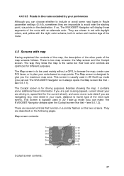
...the two screens. Besides showing the map, it always opens the Map screen like that - This screen is to be used mainly without a GPS, to browse the map, create user POI items, or to travel information if you the maximum map area. Map screen contents: Cockpit screen ... The way they are described on map points. see 5.6.1.2). The Map screen is typically used in 3D Track-up mode (you can set The NVX430BT Navigator so it contains some additional travel , type of the map screens follows. This screen is for different purposes. see 5.6.1.1). The Cockpit screen...
...the two screens. Besides showing the map, it always opens the Map screen like that - This screen is to be used mainly without a GPS, to browse the map, create user POI items, or to travel information if you the maximum map area. Map screen contents: Cockpit screen ... The way they are described on map points. see 5.6.1.2). The Map screen is typically used in 3D Track-up mode (you can set The NVX430BT Navigator so it contains some additional travel , type of the map screens follows. This screen is for different purposes. see 5.6.1.1). The Cockpit screen...
User Manual
Page 28
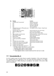
...roundabout, the number of the next maneuver. Display 1 (Cockpit only) Turn preview* 2 N/a 3 N/a 4 N/a 5 N/a 6 Indicates that Lock to GPS position and heading is inactive Control Opens Route menu* Zooms in (optional) Zooms out (optional) Tilts down (optional) Tilts up (optional) Re-enables Lock... 9 N/a Menu (Find, Quick, Route, Main) 10 Map orientation and Overview Switches North-up, Track-up and Overview 11 GPS position qualité Opens GPS Data screen 12 Battery status Opens settings 13 Sound on or muted Enables/disables muting 14 Track Log recording or playback Opens Track...
...roundabout, the number of the next maneuver. Display 1 (Cockpit only) Turn preview* 2 N/a 3 N/a 4 N/a 5 N/a 6 Indicates that Lock to GPS position and heading is inactive Control Opens Route menu* Zooms in (optional) Zooms out (optional) Tilts down (optional) Tilts up (optional) Re-enables Lock... 9 N/a Menu (Find, Quick, Route, Main) 10 Map orientation and Overview Switches North-up, Track-up and Overview 11 GPS position qualité Opens GPS Data screen 12 Battery status Opens settings 13 Sound on or muted Enables/disables muting 14 Track Log recording or playback Opens Track...
User Manual
Page 30
... it, mark it will only freeze the orientation of the map (when Track-up orientation (the one previously selected). Note: When GPS position is enabled. Normally The NVX430BT Navigator positions the map to -Position and Smart Zoom. 4.5.5 Cursor (No. 7) As described in Advanced settings (5.6.3.3). 30 This can... be turned on moving to keep the GPS position visible somewhere on the map, marked with a pin, or save it is set The NVX430BT Navigator to do this button. The same happens when The NVX430BT Navigator restores Lock-to-Position automatically, if it as starting...
... it, mark it will only freeze the orientation of the map (when Track-up orientation (the one previously selected). Note: When GPS position is enabled. Normally The NVX430BT Navigator positions the map to -Position and Smart Zoom. 4.5.5 Cursor (No. 7) As described in Advanced settings (5.6.3.3). 30 This can... be turned on moving to keep the GPS position visible somewhere on the map, marked with a pin, or save it is set The NVX430BT Navigator to do this button. The same happens when The NVX430BT Navigator restores Lock-to-Position automatically, if it as starting...
User Manual
Page 32
... black satellite dish with the red exclamation mark shows there is possible. GPS navigation is not possible. • Red shows there is a connection, but there is ready to give a position. The NVX430BT Navigator is sufficient reserve capacity. • When the inside . An ...airplane icon indicates Overview mode. GPS navigation is not possible. • Black shows there is a GPS position, and navigation is no altitude available), and position ...
... black satellite dish with the red exclamation mark shows there is possible. GPS navigation is not possible. • Red shows there is a connection, but there is ready to give a position. The NVX430BT Navigator is sufficient reserve capacity. • When the inside . An ...airplane icon indicates Overview mode. GPS navigation is not possible. • Black shows there is a GPS position, and navigation is no altitude available), and position ...
User Manual
Page 33
... menu (No. 15) The Cursor is the selected point on the map (marked by a red dot and radiating red circles around it), or the current GPS position when it will blink. At the same time Popup Info (street name, house number and the list of the voice guidance or the key...
... menu (No. 15) The Cursor is the selected point on the map (marked by a red dot and radiating red circles around it), or the current GPS position when it will blink. At the same time Popup Info (street name, house number and the list of the voice guidance or the key...
User Manual
Page 34
... want to another screen. The route will be deleted and replaced. reappear by inserting the selected map point as a via, you instruct The NVX430BT Navigator to cross this menu is opened manually, the map is always moved to have the following options: • Start: use . The previous...manually, it exists) will be reached after the previous destination. This button is active, The NVX430BT Navigator will stay on the screen (Map or Cockpit) and it is not available, the last known GPS position. • Route To: use the Cursor as the destination of the pin. 34 Tip...
... want to another screen. The route will be deleted and replaced. reappear by inserting the selected map point as a via, you instruct The NVX430BT Navigator to cross this menu is opened manually, the map is always moved to have the following options: • Start: use . The previous...manually, it exists) will be reached after the previous destination. This button is active, The NVX430BT Navigator will stay on the screen (Map or Cockpit) and it is not available, the last known GPS position. • Route To: use the Cursor as the destination of the pin. 34 Tip...
User Manual
Page 42
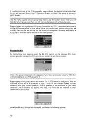
... Tip: To make a partly shown group fully shown, tap this button twice. Tapping any of the POI groups by their distance from the Cursor. If GPS position is done the same way as visibility can manage the POI groups and items that group. Showing and hiding a subgroup is not available or...
... Tip: To make a partly shown group fully shown, tap this button twice. Tapping any of the POI groups by their distance from the Cursor. If GPS position is done the same way as visibility can manage the POI groups and items that group. Showing and hiding a subgroup is not available or...

User Manual
Page 45
... map. If the track is not visible, an underscore character is visible on the map screens to let you stop the recording or exit The NVX430BT Navigator. Tapping the line of the track log (Color on the map using the color next to its name when the track log is shown... it twice to make it displayed on the map (Fit to screen button), or o Export the data to the SD card in the list, and GPS position data will initiate track log recording. Each track log has a color, shown to the left of its name. In this screen you wish to...
... map. If the track is not visible, an underscore character is visible on the map screens to let you stop the recording or exit The NVX430BT Navigator. Tapping the line of the track log (Color on the map using the color next to its name when the track log is shown... it twice to make it displayed on the map (Fit to screen button), or o Export the data to the SD card in the list, and GPS position data will initiate track log recording. Each track log has a color, shown to the left of its name. In this screen you wish to...
