Garmin GPSMAP 78sc Support Question
Garmin GPSMAP 78sc Support Question
Find answers below for this question about Garmin GPSMAP 78sc.Need a Garmin GPSMAP 78sc manual? We have 3 online manuals for this item!
Question posted by Anonymous-133438 on April 1st, 2014
How Do I Load Canadian Charts?
The person who posted this question about this Garmin product did not include a detailed explanation. Please use the "Request More Information" button to the right if more details would help you to answer this question.
Current Answers
Answer #1: Posted by TheWiz on April 1st, 2014 12:56 PM
TheWiz

Member since:
October 13th, 2011 Points: 25,383,424

Member since:
October 13th, 2011 Points: 25,383,424
Related Garmin GPSMAP 78sc Manual Pages
Owner's Manual - Page 1
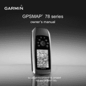
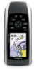
GPSMAP® 78 series
owner's manual
for use with the GPSMAP 78, GPSMAP 78S, and GPSMAP 78Sc
Owner's Manual - Page 6

Getting Started
Device Overview
Internal antenna
Buttons
Display
2
MCX connector for external GPS antenna (under weather cap)
Serial port (under weather cap)
mini-USB port (under weather cap)
Battery compartment
microSD™ card slot (under batteries)
GPSMAP 78 Series Owner's Manual
Owner's Manual - Page 8

... your current location as a waypoint and begin navigation to store your location. 4. The GPS bars indicate satellite strength. Press and hold MOB (man overboard function) to that point....acquired satellite signals.
4
Buttons
Button FIND/MOB
Description
Press FIND to acquire signals. 1. GPSMAP 78 Series Owner's Manual Quickly press to an open the backlight status page. Go outdoors ...
Owner's Manual - Page 13
... as restaurants, hotels, and auto services.
1. Enter the country.
4. Enter the street. 8. Select Marine Services. 3.
Enter the house number. 7. Select a destination. 5. Press FIND.
2. Select Addresses.
... the city or postal code. NOTE: Not all map data provides postal code searching.
5. GPSMAP 78 Series Owner's Manual
9 Additional Maps
To purchase preloaded detailed map data cards, go to...
Owner's Manual - Page 14
... track. 3. NOTE: Using the Most Often interval provides the most track detail and fills up the device memory quicker.
10
GPSMAP 78 Series Owner's Manual You can view archived or loaded tracks by selecting Track Manager from the main menu.
Tracks
Tracks
About Tracks
Your Garmin device records a track log while you...
Owner's Manual - Page 18
... destination, the bearing pointer points to enable or disable the maps currently loaded on -screen instructions.
14
GPSMAP 78 Series Owner's Manual
Using the Main Pages
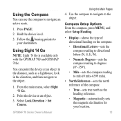
• Map Information-allows... Do not stand near objects that direction until the arrow is available only with the GPSMAP 78S and GPSMAP 78Sc. Select Calibrate Compass > Start.
3. From the compass, press MENU.
2. When the...
Owner's Manual - Page 19
... active route.
1.
Using Sight 'N Go
NOTE: Sight 'N Go is available only with the GPSMAP 78S and GPSMAP 78Sc.
Compass Setup Options From the compass, press menu, and select Setup Heading.
• Display-... Sight 'N Go.
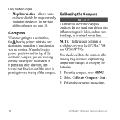
2. Use the compass to navigate to
your location.
15 Press page. 2. GPSMAP 78 Series Owner's Manual
Using the Main Pages
4. Using the Compass
You can point the device at an...
Owner's Manual - Page 20
...switch from an electronic compass to select how the course is available only with the GPSMAP 78S and GPSMAP 78Sc. Using the Main Pages
◦◦ Grid-sets grid north as the heading ...reference (0°).
◦◦ User-sets the magnetic variation value.
• Go To Line/Pointer-allows you to a GPS...
Owner's Manual - Page 23
.... Go to your device (page 35).
2. Main Menu Features and Settings
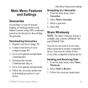
Geocaches
Geocaching is available only with the GPSMAP 78S and GPSMAP 78Sc.
Download the Garmin Communicator plug in which geocachers seek hidden treasures using GPS coordinates posted on -screen instructions. Share Wirelessly
note: The share wirelessly feature is a type of the compatible Garmin...
Owner's Manual - Page 25
...
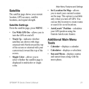
• Sun and Moon-displays sunrise and sunset times along with your current location on and off GPS.
GPSMAP 78 Series Owner's Manual
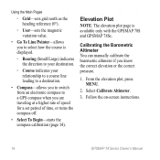
21 This option is displayed in multicolor or single color. You can use this... AutoLocate® Position-calculates your current location, GPS accuracy, satellite locations, and signal strength. Satellite Settings From the satellite page, press menu.
•...
Owner's Manual - Page 27
... **Ascent Maximum
**Ascent - The remaining battery power. GPSMAP 78 Series Owner's Manual
23 Follow the on each main page.
1.
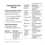
Data Field Accuracy of GPS
Description
The margin of error for your GPS location is accurate to a destination. The maximum ascent rate... fields displayed on -screen instructions.
Data Field Options
** Available only with the GPSMAP 78S and GPSMAP 78Sc.
Owner's Manual - Page 28
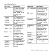
... destination.
The maximum descent rate in feet/meter per minute (bpm). The altitude of the GPS signal. The highest elevation reached.
The glide ratio required to the change in beats
(heart rate monitor per minute. required)
24
GPSMAP 78 Series Owner's Manual The remaining distance to Next
Elevation
**Elevation - Heading
The direction...
Owner's Manual - Page 29
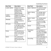
... the water.
since last reset. Time of Day
The current time of day based on your GPS position.
Overall Your average speed
Avg.
The distance to acquire data (page 27). Water
The ... while moving since last reset.
Speed - The average speed of sunset based on your GPS position.
Displays the current position in the selected position format. Sunrise
The time of travel...
Owner's Manual - Page 31

... to Normal, WAAS/EGNOS (Wide Area Augmentation System/European Geostationary Navigation Overlay Service), or Demo Mode (GPS off). GPSMAP 78 Series Owner's Manual
27 System Settings
From the main menu, select Setup > System.
• GPS-sets the GPS to www.garmin.com/aboutGPS/waas .html.
• Language-sets the text language on the device...
Owner's Manual - Page 32
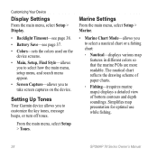
..., or turn off tones. Marine Settings
From the main menu, select Setup > Marine.
• Marine Chart Mode-allows you to select a nautical chart or a fishing chart:
◦◦ Nautical-displays various map features in different colors so that the marine POIs are more readable. Simplifies map presentation for optimal use while fishing.
28
GPSMAP 78 Series Owner's Manual...
Owner's Manual - Page 33
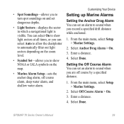
... the sector in which a navigational light is visible. Enter a distance. 4. Select Done. Select Off Course Alarm > On. 3. Select Done. GPSMAP 78 Series Owner's Manual
29 From the main menu, select Setup > Marine Settings.
2.
Enter a distance. 4.
• Spot Soundings-allows you to sound when you are off course alarm, deep water alarm, and...
Owner's Manual - Page 34
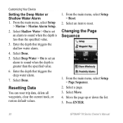
...1. From the main menu, select Setup > Page Sequence.
2. From the main menu, select Setup
> Marine > Marine Alarm Setup.
2. Select Done.
5. Resetting Data
You can reset trip data, delete all waypoints, clear...triggers the shallow water alarm.
4. Select a page. 3. Press Enter.
30
GPSMAP 78 Series Owner's Manual Select Shallow Water > On to set an alarm to reset. Enter the depth ...
Owner's Manual - Page 35
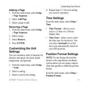
... time zone automatically based on your GPS position.
Removing a Page 1. Select a page. 3. Select a unit for each setting you are using a map or chart that specifies a different position format....3. Press Enter. Adding a Page 1. Select a page to customize. GPSMAP 78 Series Owner's Manual
Customizing Your Device
4.
From the main menu, select Setup
> Page Sequence. 2.
...
Owner's Manual - Page 38
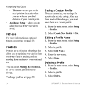
...the new name.
5.
Select Create New Profile > OK. Deleting a Profile 1. Select Delete.
34
GPSMAP 78 Series Owner's Manual Select a profile.
3. To change profiles, see page 39. From the ....
4.
Select a profile.
3. Saving a Custom Profile You can select Marine, Recreational, or save them as moving from marine use to recreational use to another, such as a custom profile.
1....
Owner's Manual - Page 52

... 19 navigating 19 settings 32 GPS signals 4, 21, 23, 24, 37, 45 system settings 27 turning off GPS 21
H HomePort 40 hunting and...marine settings 28-29 MARK button 5 MCX connector 2 measuring area 20 distance 13 MENU button 5, 12, 17, 23 microSD card 36, 39-41 MOB button 4 moonphase 21
N navigating
compass 14 routes 8 to geocaches 19 to waypoints 6 tracks 11
48
GPSMAP...
Similar Questions

How Do I Go Into Simulation Mode On A Garmin Marine Gps Modle741xs
how do I use simulation mode on a garmin 741xs marine ver
how do I use simulation mode on a garmin 741xs marine ver
(Posted by Curthupp 6 years ago)

Not Acquiring Satellite Garmin Gps 78
What do i do if my Garmin GPS 78 does not acquire any sattelites?
What do i do if my Garmin GPS 78 does not acquire any sattelites?
(Posted by vitawyler 7 years ago)

Our Garmin Will Not Power Up. Does It Have To Have Sim Card To Power Up?
(Posted by dudleybv 8 years ago)

541s Marine Gps. Depth Not Reading Out.
Depth has been working since installed. Now blank. Is there an on off control for this that may have...
Depth has been working since installed. Now blank. Is there an on off control for this that may have...
(Posted by therad50 11 years ago)