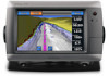
Garmin GPSMAP 720 Support Question
Garmin GPSMAP 720 Support Question
Find answers below for this question about Garmin GPSMAP 720.Need a Garmin GPSMAP 720 manual? We have 7 online manuals for this item!
Question posted by nickholmes on April 1st, 2012
Depth Trouble
can anyone help please?
i have a 720 chartplotter, when i first start my boat and crawl along at 6knots the depth sounder works fine, then when i give it some throttle , it flashes at the depth i was at when i gave it throttle, it will only flash that depth, i have to switch it off to regain the depth sounder, its good for 6 knots but after that its no use.
Current Answers
Related Garmin GPSMAP 720 Manual Pages
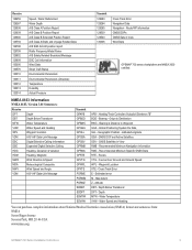
Technical Reference for Garmin NMEA 2000 Products - Page 3
... a NMEA 2000 network on your boat.
• The second section, General NMEA 2000 Data Type Requirements, provides a table to help you determine which NMEA 2000 sensors provide the particular data type you want.
• The last two sections provide Parameter Group Number (PGN) information for Garmin chartplotters and marine instruments as well as configuration...
Technical Reference for Garmin NMEA 2000 Products - Page 13
... to the NMEA 2000-certified display devices (such as a GPSMAP 4000/5000 series chartplotter or a GMI 10) on the sensors you have installed and...Chartplotter and GPS Antenna
Garmin Chartplotter and GPS Antenna
Garmin Chartplotter Garmin Chartplotter and GPS Antenna Garmin Chartplotter and GPS Antenna Garmin Chartplotter and GPS Antenna Garmin Chartplotter and GPS Antenna Heading Sensor GPS...
Technical Reference for Garmin NMEA 2000 Products - Page 17
... display device, see the owner's manual for Garmin NMEA 2000 Products 13 GPSMAP 6000/7000 Series Chartplotters
Receive
059392 ISO Acknowledgment
059904 ISO Request
060928 ISO Address Claim
126208 NMEA... ISO Address Claim NMEA - Rapid Update
129026 COG & SOG - Water Referenced Water Depth Position - The following tables list the non-proprietary PGN information for all Garmin NMEA 2000...
Technical Reference for Garmin NMEA 2000 Products - Page 38

... GST 10 adapter, you must assign each adapter is assigned a unique sensor number automatically. Accelerate the boat to each adapter. Select an option:
• For most Garmin chartplotters, select Review > Generic Config. • For other Garmin marine devices, select Config > Sensor Number. 3. For example, WATERSPEED=35.5Done. To configure the temperature source if...
Installation Instructions - Page 1
...
Help us better support you have been included for your boat. The serial number is located on a sticker on the box.
Mount the GPSMAP 700 series chartplotter in...chartplotter to a NMEA 2000 network (page 6) • Connecting the chartplotter to a GA 30 remote GPS antenna (page 6). • Connecting the chartplotter to a Garmin marine radar (page 6). • Connecting the chartplotter...
Installation Instructions - Page 2
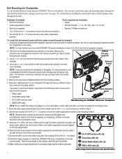
...; GA 30 GPS antenna cable clip ➋ Power/data cable clip ➌ Garmin Marine Radar cable clip ➍ NMEA 2000 cable clip
Cable-Organization-Bracket Clip Identification
GPSMAP 700 Series Installation Instructions NOTE: To avoid interference, mount the GPSMAP 700 series chartplotter at which you are tightened.
5. GPSMAP 700 series chartplotter
3. This will help to avoid any...
Installation Instructions - Page 6
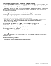
... provided with a Garmin marine radar, but some installations, such as a GMR™ 18 HD (not included).
Connecting the Chartplotter to a Transducer
If you have a sonar-cable GPSMAP 700 series chartplotter (indicated by an "s" in an appropriate location and connect it to the chartplotter to a GA 30 Remote GPS Antenna (Optional)
The GPSMAP 700 series chartplotter has an internal...
Installation Instructions - Page 8
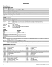
...
Fully Gasketed, high-impact plastic and aluminum alloy, waterproof to 55°C)
Compass Safe 32 in. (813 mm) Distance
GPS Performance
Specification Parameter
Receiver
Acquisition Time
Warm Cold
Reacquisition
Update Rate
Accuracy
GPS
DGPS
Velocity
Measurement High-sensitivity 12 parallel channel, WAAS-capable receiver Approximately 1 sec. (The device is at or near...
Installation Instructions - Page 9
... DOP and Active Satellites GSV - Map datum Z - Water Temperature VHW - Course Over Ground and Ground Speed WPL - Depth Below Transducer DPT - Recommended Minimum Specific GNSS Data RTE - Depth MTW - GNSS Satellites in View Wind Data
GPSMAP 700 series chartplotters are NMEA 2000 certified. Routes VTG - Estimated error M -
Origin to Waypoint GGA - Water Referenced Water...
Quick Reference Guide - Page 2

... the map from the bow of the boat in the direction of time until you ...Display screen.
2. Garmin®, the Gamin logo, GPSMAP®, BlueChart®, and g2 Vision® ...MOB point and the chartplotter sets a course back to the settings for minimum safe water depth and minimum safe ...the Home screen, select Charts. 2. Navigating to a Marine Service
Navigating to an MOB Location When you want ...
Owner's Manual - Page 3
...
• GPSMAP® 720/720s • GPSMAP 740/740s • GPSMAP 750/750s
...Tips and Shortcuts
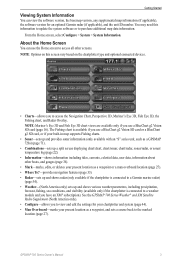
• Select Home from any screen to return to the Home screen. • Select Menu from any main screen to access additional settings. • Press and release to adjust the Backlight and Color Mode settings. • Press and hold to turn the chartplotter...
Owner's Manual - Page 4

... Conventions i
Getting Started 1 Front and Back Panels 1 Turning On the Chartplotter 1 Turning Off the Chartplotter 1 Initial Chartplotter Settings 2 GPS Satellite Signal Acquisition ...Chartplotter 25 Waypoints 26 Routes 28 Tracks 30 Navigating with a Garmin Autopilot 32
Where To 33 Marine Services Destinations 33
Almanac, On-boat, and Environmental Data 36 Almanac Data 36 On-boat...
Owner's Manual - Page 6
... a computer (page 52). Getting Started
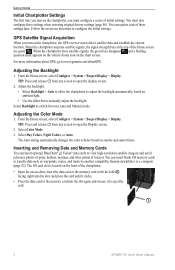
Initial Chartplotter Settings
The first time you turn on the chartplotter, you turn on sunrise and sunset times. You must collect satellite data and establish the current location.
When the chartplotter loses satellite signals, the green bars disappear and a flashing question mark appears on the vehicle (boat) icon on the chart...
Owner's Manual - Page 7
... (available only if the chartplotter is connected to a weather module and you use a BlueChart g2 Vision SD card or a BlueChart g2 SD card, or if your built-in map supports Fishing charts.
• Sonar-sets up and provides sonar information (only available with an "S" series unit, such as a GPSMAP 720s) (page 71).
•...
Owner's Manual - Page 20

...Mariner's Eye 3D. 3.
Note: Mariner's Eye 3D is on or off.
16
GPSMAP 700 Series Owner's Manual Enter the width. 5.
BlueChart g2 Vision data cards are not using the card, keep it away from above and behind the boat...help you to the card.
Using Waypoints and Tracks See "Waypoints" (page 26) or "Tracks" (page 30). This chart works... Appearance of your chartplotter is available with ...
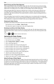
Owner's Manual - Page 52
...be shown or hidden in sounder to view depth and temperature information. Complete an action:
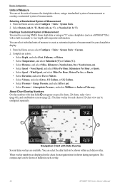
• Select Depth, and select Feet, ...depth data or using a standardized system of measurements or creating a customized system of measurements. Device Configuration
Units of Measure You can set the units of measure the chartplotter shows, using an "S" series chartplotter (such as a GPSMAP 720s...
Owner's Manual - Page 66
...Viewing information about shorter-range targets.
62
GPSMAP 700 Series Owner's Manual
Restore the default value of the crosstalk setting (page 66). 9. If the boat heading is based on the most-recently ... the chartplotter aligns radar data with chart data based on the boat heading, which is based by default on GPS tracking data. If a heading sensor is not available, the boat heading ...
Owner's Manual - Page 75

...10122; Range adjustment buttons ➋ Depth, water speed, and unit voltage
➌ Suspended target
➍ Bottom
➎ Range
➏ GPS speed and GPS heading
➐ Transducer frequency
Setting... in to set the depth range of detected objects as fishfinders: • GPSMAP 720s • GPSMAP 740s • GPSMAP 750s
Sonar Views
The chartplotter shows sonar data using three...
Owner's Manual - Page 94
... 58 deep water 77 fish 77 GPS accuracy 52 navigation 51 off course ...chart symbols 5 data cards 16 Fish Eye 3D 18 Mariner's Eye 3D 17 POIs 21
bridging, output 88 ...compass tape data bar 24, 49, 67 configuration, chartplotter 44 configure, button 3 contact information 89 coordinate systems... 2 deep water alarm 77 depth log 73 depth shading 10 destinations 25 navigating to...GPSMAP 700 Series Owner's Manual
Owner's Manual - Page 95
...zoom detail 8
fish symbols 19, 75 front-of-boat offset 69 front panel 1 FTC 63, 65 ...26, 33 GPS accuracy alarm 52 performance 84 signals 2 GPS performance 84... range rings 15 safe depth 18 satellite imagery 17 marine services 11, 25,...depth 10 data bars 48 depth shading 10 heading line 9 land-based POIs 11 light sectors 11 marine...off course alarm 51 offset
front of boat 69 keel 78 water temperature 78 ...
Similar Questions

How Do I Go Into Simulation Mode On A Garmin Marine Gps Modle741xs
how do I use simulation mode on a garmin 741xs marine ver
how do I use simulation mode on a garmin 741xs marine ver
(Posted by Curthupp 6 years ago)
Garmin 720s Chartplotter
hi how do i enter long and lat on my chartplotter. thanks
hi how do i enter long and lat on my chartplotter. thanks
(Posted by franknuccio 9 years ago)


541s Marine Gps. Depth Not Reading Out.
Depth has been working since installed. Now blank. Is there an on off control for this that may have...
Depth has been working since installed. Now blank. Is there an on off control for this that may have...
(Posted by therad50 11 years ago)

Depth Sounder Not Working
I have a garmin 178C and the depth sounder works fine at slow speeds but as soon as I pick up the sp...
I have a garmin 178C and the depth sounder works fine at slow speeds but as soon as I pick up the sp...
(Posted by flyodd1 13 years ago)