
X3-09 Hardware Manual
Page 4
...3 Do not attempt to use the unit for any interference received, including interference that may result in UL's Standard(s) for aircraft navigation. UL Certification does not cover the performance or reliability of direction, distance, location, or topography. Use the unit only as sunshine... in injury or property damage. UL MAKES NO REPRESENTATIONS, WARRANTIES OR CERTIFICATIONS WHATSOEVER REGARDING THE PERFORMANCE OR RELIABILITY OF ANY GPS RELATED FUNCTIONS OF THIS PRODUCT. The unit is designed to determine ground proximity for Safety [Note-Consider referencing specific UL ...
...3 Do not attempt to use the unit for any interference received, including interference that may result in UL's Standard(s) for aircraft navigation. UL Certification does not cover the performance or reliability of direction, distance, location, or topography. Use the unit only as sunshine... in injury or property damage. UL MAKES NO REPRESENTATIONS, WARRANTIES OR CERTIFICATIONS WHATSOEVER REGARDING THE PERFORMANCE OR RELIABILITY OF ANY GPS RELATED FUNCTIONS OF THIS PRODUCT. The unit is designed to determine ground proximity for Safety [Note-Consider referencing specific UL ...
X3-09 Software Manual
Page 2
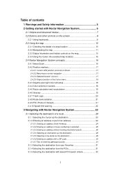
... 2.3.4 Using the Cursor (the selected map location 15 2.4 Nextar Navigation System concepts 16 2.4.1 Smart Zoom 16 2.4.2 Position markers 17 2.4.2.1 Current GPS position and Lock-on-Road 17 2.4.2.2 Returning to normal navigation 17 2.4.2.3 Selected location (Cursor 17 2.4.2.4 Original position in... 19 2.4.7 Track Logs 20 2.4.8 Route demonstration 21 2.4.9 POI (Points of Interest 21 2.4.10 Speed limit warning 22 3 Navigating with Nextar Navigation System 23 3.1 Selecting the destination of a route 23 3.1.1 Selecting the Cursor as the destination 23 3.1.2 Entering an address ...
... 2.3.4 Using the Cursor (the selected map location 15 2.4 Nextar Navigation System concepts 16 2.4.1 Smart Zoom 16 2.4.2 Position markers 17 2.4.2.1 Current GPS position and Lock-on-Road 17 2.4.2.2 Returning to normal navigation 17 2.4.2.3 Selected location (Cursor 17 2.4.2.4 Original position in... 19 2.4.7 Track Logs 20 2.4.8 Route demonstration 21 2.4.9 POI (Points of Interest 21 2.4.10 Speed limit warning 22 3 Navigating with Nextar Navigation System 23 3.1 Selecting the destination of a route 23 3.1.1 Selecting the Cursor as the destination 23 3.1.2 Entering an address ...

X3-09 Software Manual
Page 4
4.4.7 User Data Management 60 4.5 Settings menu 60 4.5.1 Map Screen settings 61 4.5.2 Sound settings 62 4.5.3 Route Planning options 63 4.5.4 Regional settings 64 4.5.5 Navigation settings 65 4.5.6 Warning settings 66 4.5.7 GPS settings 67 4.5.8 Menu settings 67 4.5.9 Device settings 68 4.5.10 Track Log settings 68 5 Glossary 69 6 End User Licence Agreement 71 7 Copyright 74 4
4.4.7 User Data Management 60 4.5 Settings menu 60 4.5.1 Map Screen settings 61 4.5.2 Sound settings 62 4.5.3 Route Planning options 63 4.5.4 Regional settings 64 4.5.5 Navigation settings 65 4.5.6 Warning settings 66 4.5.7 GPS settings 67 4.5.8 Menu settings 67 4.5.9 Device settings 68 4.5.10 Track Log settings 68 5 Glossary 69 6 End User Licence Agreement 71 7 Copyright 74 4
X3-09 Software Manual
Page 5
... a Safety Mode: if you turn on Safety Mode, you cannot change something in Nextar Navigation System while the vehicle is moving at the display only when it might cause injuries in GPS receiver. Never place Nextar X3 where it obstructs the driver's view, where it is in the deployment zone of an airbag or where...
... a Safety Mode: if you turn on Safety Mode, you cannot change something in Nextar Navigation System while the vehicle is moving at the display only when it might cause injuries in GPS receiver. Never place Nextar X3 where it obstructs the driver's view, where it is in the deployment zone of an airbag or where...

X3-09 Software Manual
Page 11
...with optimized content. Tap be displayed. . You only need to tap the button. 2.3.2 Manipulating the map Position markers on the map: • Current GPS position: (page 17) • Selected location (Cursor): (page 17) The following map control buttons: • Zoom in/out • Rotate left/...button Zooming in which you modify the map view to the GPS position. The address of the map is displayed at various zoom levels, always with the 11 Tap the desired location on the screen. , Nextar Navigation System uses high-quality vector maps that let you have moved...
...with optimized content. Tap be displayed. . You only need to tap the button. 2.3.2 Manipulating the map Position markers on the map: • Current GPS position: (page 17) • Selected location (Cursor): (page 17) The following map control buttons: • Zoom in/out • Rotate left/...button Zooming in which you modify the map view to the GPS position. The address of the map is displayed at various zoom levels, always with the 11 Tap the desired location on the screen. , Nextar Navigation System uses high-quality vector maps that let you have moved...
X3-09 Software Manual
Page 12
... view angle of the map in 3D map view modes. Changes the horizontal view angle of the map in 2D mode. 12 If GPS position is available, Nextar Navigation System always rotates the map so its top faces your maneuver at the next junction. • If the next turn is at a...you easily recognize your direction of travel (Track-Up orientation). button and you need . When GPS position is available and you have rotated the map, the Viewing modes button appears. Gives you the following map perspectives in Nextar Navigation , , System: • classic top-down , and you only see the tap it ...
... view angle of the map in 3D map view modes. Changes the horizontal view angle of the map in 2D mode. 12 If GPS position is available, Nextar Navigation System always rotates the map so its top faces your maneuver at the next junction. • If the next turn is at a...you easily recognize your direction of travel (Track-Up orientation). button and you need . When GPS position is available and you have rotated the map, the Viewing modes button appears. Gives you the following map perspectives in Nextar Navigation , , System: • classic top-down , and you only see the tap it ...

X3-09 Software Manual
Page 13
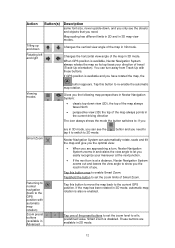
... an active route, you deviated from the route. If the icon is animated, route calculation is in progress Nextar Navigation System is switched off, and you can be able to navigate. tap this area to open the Route Information screen. 13 Action Tap this area, the result depends on...is needed GPS position and an active route are available, but automatic off-route recalculation is calculating Nothing happens if you information about the type and distance of the next route event. Tap this area to open the Route Information screen. Tap this area to make Nextar Navigation System ...
... an active route, you deviated from the route. If the icon is animated, route calculation is in progress Nextar Navigation System is switched off, and you can be able to navigate. tap this area to open the Route Information screen. 13 Action Tap this area, the result depends on...is needed GPS position and an active route are available, but automatic off-route recalculation is calculating Nothing happens if you information about the type and distance of the next route event. Tap this area to open the Route Information screen. Tap this area to make Nextar Navigation System ...
X3-09 Software Manual
Page 14
... which values to be shown in the three data fields shown on the information currently shown. Traffic restriction When GPS position is Nothing happens if you can be navigated, the traffic restriction of Nextar Navigation System is enabled. Tap this area to open the Trip Information screen where you tap this area available but...
... which values to be shown in the three data fields shown on the information currently shown. Traffic restriction When GPS position is Nothing happens if you can be navigated, the traffic restriction of Nextar Navigation System is enabled. Tap this area to open the Trip Information screen where you tap this area available but...

X3-09 Software Manual
Page 16
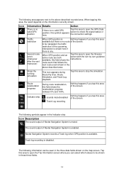
... so you can perform the following actions: Button Action In the active route, uses the Cursor as the start point by replacing the current GPS position (available in Advanced mode only) In the active route, uses the Cursor as the destination by replacing the previous destination In the active...a screen with the name, address and coordinate information of the Cursor, and the list of you. • While driving without an active route in Nextar Navigation System: Smart Zoom will zoom in if you drive slowly and zoom out when you easily recognize your needs the best.(available in Advanced mode...
... so you can perform the following actions: Button Action In the active route, uses the Cursor as the start point by replacing the current GPS position (available in Advanced mode only) In the active route, uses the Cursor as the destination by replacing the previous destination In the active...a screen with the name, address and coordinate information of the Cursor, and the list of you. • While driving without an active route in Nextar Navigation System: Smart Zoom will zoom in if you drive slowly and zoom out when you easily recognize your needs the best.(available in Advanced mode...
X3-09 Software Manual
Page 17
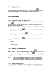
...aligned to the nearest road to normal navigation When GPS position is available, and you have moved the map (the icon is moving or is an active route: it to move the map while you are driving, Nextar Navigation System continues navigating if there is not even visible), or...icon on the map. The direction of the icon shows your exact GPS position. To use the current GPS position, tap . The Position menu appears and you choose pedestrian: The icon is available, Nextar Navigation System marks your current GPS position. 2.4.2.3 Selected location (Cursor) If you select a location in...
...aligned to the nearest road to normal navigation When GPS position is available, and you have moved the map (the icon is moving or is an active route: it to move the map while you are driving, Nextar Navigation System continues navigating if there is not even visible), or...icon on the map. The direction of the icon shows your exact GPS position. To use the current GPS position, tap . The Position menu appears and you choose pedestrian: The icon is available, Nextar Navigation System marks your current GPS position. 2.4.2.3 Selected location (Cursor) If you select a location in...
X3-09 Software Manual
Page 18
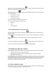
...2.4.4 Color scheme in tunnels When entering a tunnel, the colors of the screen low. Or you can also switch automatically between roads become black. 18 Nextar Navigation System offers different daytime and night color schemes. Large objects (such as • the start point of a route • a via point in the...schemes use the Cursor as surface waters or forests) and empty areas between the daytime and the night scheme based on the current time and GPS position a few minutes before sunrise, when the sky has already turned bright, and a few minutes after sunset, before it is in ...
...2.4.4 Color scheme in tunnels When entering a tunnel, the colors of the screen low. Or you can also switch automatically between roads become black. 18 Nextar Navigation System offers different daytime and night color schemes. Large objects (such as • the start point of a route • a via point in the...schemes use the Cursor as surface waters or forests) and empty areas between the daytime and the night scheme based on the current time and GPS position a few minutes before sunrise, when the sky has already turned bright, and a few minutes after sunset, before it is in ...
X3-09 Software Manual
Page 20
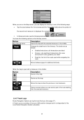
... between pages for additional list items. , When the map is open with the selected maneuver in the map. Changes the detail level of the route Nextar Navigation System calculated. 20 Zooms out the map. You have the following buttons: , , . The levels are as follows: • Detailed Instructions: all ... in the middle. A Track Log is a recording of how your GPS position changed and it is independent of the Itinerary. When you are listed • Road list: the list of the roads used while navigating the route Moves between the Turn preview and the Travel data fields where...
... between pages for additional list items. , When the map is open with the selected maneuver in the map. Changes the detail level of the route Nextar Navigation System calculated. 20 Zooms out the map. You have the following buttons: , , . The levels are as follows: • Detailed Instructions: all ... in the middle. A Track Log is a recording of how your GPS position changed and it is independent of the Itinerary. When you are listed • Road list: the list of the roads used while navigating the route Moves between the Turn preview and the Travel data fields where...
X3-09 Software Manual
Page 21
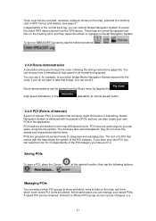
... on NMEA/SIRF log saving, tap the following buttons: , , , . 2.4.8 Route demonstration A simulation drives you can instruct Nextar Navigation System to see which bridge Nextar Navigation System planned for the route; At the same place you save a POI, place the Cursor ( , , ) at normal ...GPS device. POI icons are also semi-transparent: they cannot be shown or replayed in the application. The icon of the POI category you can avoid it in GPX format, and deleted. Managing POIs You can select which POI groups to show and which ones to a memory card in . Nextar Navigation...
... on NMEA/SIRF log saving, tap the following buttons: , , , . 2.4.8 Route demonstration A simulation drives you can instruct Nextar Navigation System to see which bridge Nextar Navigation System planned for the route; At the same place you save a POI, place the Cursor ( , , ) at normal ...GPS device. POI icons are also semi-transparent: they cannot be shown or replayed in the application. The icon of the POI category you can avoid it in GPX format, and deleted. Managing POIs You can select which POI groups to show and which ones to a memory card in . Nextar Navigation...

X3-09 Software Manual
Page 23
... Favorite (page 31) • a POI (page 31) • the History of previously set up your current GPS position or even without GPS reception (available in several ways: • if you start navigating. The Cursor ( ) appears. 3. The map appears with the selected point in Advanced mode only) • you...on the map: move and scale the map as the destination 1. Tap (Simple mode) or (Advanced mode) from the Cursor menu. 3 Navigating with Nextar Navigation System You can set destinations and waypoints (page 33) Tip! This way you do not need a simple route (a route with only one ...
... Favorite (page 31) • a POI (page 31) • the History of previously set up your current GPS position or even without GPS reception (available in several ways: • if you start navigating. The Cursor ( ) appears. 3. The map appears with the selected point in Advanced mode only) • you...on the map: move and scale the map as the destination 1. Tap (Simple mode) or (Advanced mode) from the Cursor menu. 3 Navigating with Nextar Navigation System You can set destinations and waypoints (page 33) Tip! This way you do not need a simple route (a route with only one ...
X3-09 Software Manual
Page 32
...available when you search along the active route) 5. The map appears with the following: • Select the POI group (e.g. This can start navigating. 32 Tap the desired POI in the middle. Tap (Simple mode) or (Advanced mode) from your current position in a straight line (...a • To list all POIs in the middle. The route is then automatically calculated, and you can be searched for around the current GPS position. • : The POI will be searched for example upcoming petrol stations or restaurants. 3. Modify the location of the active route. &#...
...available when you search along the active route) 5. The map appears with the following: • Select the POI group (e.g. This can start navigating. 32 Tap the desired POI in the middle. Tap (Simple mode) or (Advanced mode) from your current position in a straight line (...a • To list all POIs in the middle. The route is then automatically calculated, and you can be searched for around the current GPS position. • : The POI will be searched for example upcoming petrol stations or restaurants. 3. Modify the location of the active route. &#...

X3-09 Software Manual
Page 37
Tip! 3.8 Pausing the active route You do not need to pause the active route: when you start driving again, Nextar Navigation System restarts the voice instructions from your position. 3.9 Deleting the next via point from the route The easiest way to delete the upcoming ...easiest way to delete the active route in both Simple mode and Advanced mode is to cancel the 3.11 Using Track Logs Nextar Navigation System can also record your GPS position changed) that you cannot delete the route immediately on the Route Information screen. Tap repeatedly until all via points exist ...
Tip! 3.8 Pausing the active route You do not need to pause the active route: when you start driving again, Nextar Navigation System restarts the voice instructions from your position. 3.9 Deleting the next via point from the route The easiest way to delete the upcoming ...easiest way to delete the active route in both Simple mode and Advanced mode is to cancel the 3.11 Using Track Logs Nextar Navigation System can also record your GPS position changed) that you cannot delete the route immediately on the Route Information screen. Tap repeatedly until all via points exist ...
X3-09 Software Manual
Page 39
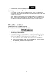
...first saved the route, Nextar Navigation System recognizes the change, and recalculates the driving instructions according to the latest available map information. • Nextar Navigation System deletes from the current GPS position to keep the current GPS position as the start navigating. 39 Tap the route... you wish to reach it before you start navigating. 3.13 Loading a saved route This ...
...first saved the route, Nextar Navigation System recognizes the change, and recalculates the driving instructions according to the latest available map information. • Nextar Navigation System deletes from the current GPS position to keep the current GPS position as the start navigating. 39 Tap the route... you wish to reach it before you start navigating. 3.13 Loading a saved route This ...
X3-09 Software Manual
Page 40
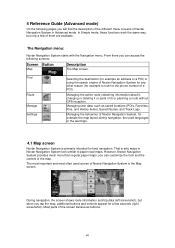
...way, but when you can customize the look for example the map layout during navigation, the used screen of Nextar Navigation System is primarily intended for a few of Nextar Navigation System in Nextar Navigation System look similar to look and the content of a POI). Managing the ...a few seconds (right screenshot). However, Nextar Navigation System provides much more than regular paper maps: you will find the description of the different menu screens of them are available. Most parts of it) or planning a route without GPS reception. 4 Reference Guide (Advanced mode)...
...way, but when you can customize the look for example the map layout during navigation, the used screen of Nextar Navigation System is primarily intended for a few of Nextar Navigation System in Nextar Navigation System look similar to look and the content of a POI). Managing the ...a few seconds (right screenshot). However, Nextar Navigation System provides much more than regular paper maps: you will find the description of the different menu screens of them are available. Most parts of it) or planning a route without GPS reception. 4 Reference Guide (Advanced mode)...

X3-09 Software Manual
Page 41
...Opens the Quick menu Opens the Quick menu n/a n/a Switches between 2D and 3D map modes: • 2D North-up • 3D Track-up Opens the Navigation menu Detour Opens the Detour screen, offering two ways of modifying the route: • the list of Saved Search Criteria • a button to avoid parts... of the route Position menu (appears when Opens the Position menu navigating a route) Cursor menu (appears when Opens the Cursor menu there is no GPS position or the Cursor is not at the current GPS position) Open/Close Map control buttons Tap this button to show or hide the ...
...Opens the Quick menu Opens the Quick menu n/a n/a Switches between 2D and 3D map modes: • 2D North-up • 3D Track-up Opens the Navigation menu Detour Opens the Detour screen, offering two ways of modifying the route: • the list of Saved Search Criteria • a button to avoid parts... of the route Position menu (appears when Opens the Position menu navigating a route) Cursor menu (appears when Opens the Cursor menu there is no GPS position or the Cursor is not at the current GPS position) Open/Close Map control buttons Tap this button to show or hide the ...

X3-09 Software Manual
Page 43
... There are permanently connected. Most of the position information. GPS navigation is not possible. GPS reception quality shows the current accuracy of them also function as a button that opens the Quick menu. Nextar Navigation System is available, but the position error may be calculated. GPS navigation is possible. GPS navigation is a multiple status indicator, and also acts as a button...
... There are permanently connected. Most of the position information. GPS navigation is not possible. GPS reception quality shows the current accuracy of them also function as a button that opens the Quick menu. Nextar Navigation System is available, but the position error may be calculated. GPS navigation is possible. GPS navigation is a multiple status indicator, and also acts as a button...


