Manual - English
Page 14
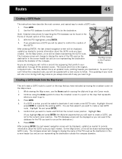
... do just about getting to any time, is finding your hiking is a "GOTO" route. Now that you along that ocean of Interest database. The destination is saving your eXplorist 210. Unless you are on a large body of the eXplorist is selected by pressing the MARK button. GOTO routes are ...set up -to-date information about any point of interest that they started. It's that , your display. While out fishing on your eXplorist automatically updates the route, providing you have saved (My Points of Interest) or points of interest stored in the future when accessing it . Next ...
... do just about getting to any time, is finding your hiking is a "GOTO" route. Now that you along that ocean of Interest database. The destination is saving your eXplorist 210. Unless you are on a large body of the eXplorist is selected by pressing the MARK button. GOTO routes are ...set up -to-date information about any point of interest that they started. It's that , your display. While out fishing on your eXplorist automatically updates the route, providing you have saved (My Points of Interest) or points of interest stored in the future when accessing it . Next ...

Manual - English
Page 18
... a cold start vs. The arrow cursor in a manner of seconds as the relative strength of the Map screen represents your present position. When the eXplorist has enough information to do a warm start. (An explanation of the sky. Without a clear view, this operation, it will point in the... ZOOM IN and ZOOM OUT buttons to change the map scale to compute your position in the center of the signal. For this will continuously update and you the progress of the collection of satellite data. As you move, the arrow will compute your initial position. Normally, when you first ...
... a cold start vs. The arrow cursor in a manner of seconds as the relative strength of the Map screen represents your present position. When the eXplorist has enough information to do a warm start. (An explanation of the sky. Without a clear view, this operation, it will point in the... ZOOM IN and ZOOM OUT buttons to change the map scale to compute your position in the center of the signal. For this will continuously update and you the progress of the collection of satellite data. As you move, the arrow will compute your initial position. Normally, when you first ...
Manual - English
Page 48
... the POI used as the destination.) 6. Highlight Yes. (If you highlight No and press ENTER, the eXplorist assumes that represents where you will be displayed, updated as needed to your The Map screen in the screen header bar and an icon representing the destination outside the diameter ...of this GOTO. The Compass screen will change to use the Arrow joystick causing the eXplorist to provide information about the...
... the POI used as the destination.) 6. Highlight Yes. (If you highlight No and press ENTER, the eXplorist assumes that represents where you will be displayed, updated as needed to your The Map screen in the screen header bar and an icon representing the destination outside the diameter ...of this GOTO. The Compass screen will change to use the Arrow joystick causing the eXplorist to provide information about the...
Manual - English
Page 49
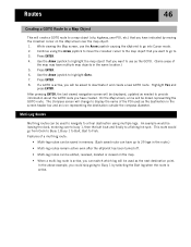
... screen, a line will be drawn representing the GOTO route. Press ENTER. 8. After pressing ENTER, the last viewed navigation screen will be displayed, updated as the next destination point. Features of the map may have multiple map objects in the same location.) 5. Continue using multiple legs. This route would... which leg will be used as needed to provide information about the GOTO route you want to go to use the Arrow joystick causing the eXplorist to go from Dock to Buoy 1,Buoy 1 to Bait, Bait to highlight Goto. 7. Use the Arrow joystick to highlight the map object...
... screen, a line will be drawn representing the GOTO route. Press ENTER. 8. After pressing ENTER, the last viewed navigation screen will be displayed, updated as the next destination point. Features of the map may have multiple map objects in the same location.) 5. Continue using multiple legs. This route would... which leg will be used as needed to provide information about the GOTO route you want to go to use the Arrow joystick causing the eXplorist to go from Dock to Buoy 1,Buoy 1 to Bait, Bait to highlight Goto. 7. Use the Arrow joystick to highlight the map object...
Manual - English
Page 75
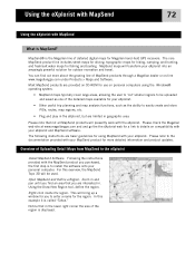
... line includes street maps for driving, topographic maps for hiking, camping, and hunting, and fresh/salt water maps for Magellan hand-held GPS receivers. MapSend maps will be uploaded and saved as the ability to install the software onto your eXplorist. • Other useful trip planning and map analysis ...will presently work with MapSend What is displayed. Please note that in and pan until you find out more detailed information and product updates. Overview of the region is MapSend? Notice that not all MapSend products will bring up a window for more about the growing ...
... line includes street maps for driving, topographic maps for hiking, camping, and hunting, and fresh/salt water maps for Magellan hand-held GPS receivers. MapSend maps will be uploaded and saved as the ability to install the software onto your eXplorist. • Other useful trip planning and map analysis ...will presently work with MapSend What is displayed. Please note that in and pan until you find out more detailed information and product updates. Overview of the region is MapSend? Notice that not all MapSend products will bring up a window for more about the growing ...
Manual - English
Page 76
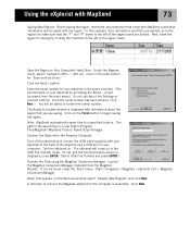
...GPS..." (Ctrl+U). Do not use any of the region name are saving. You will come up in the USB File Transfer mode. (If not, and the Communication screen is displayed with information about the region that you are bolded. Select USB File Transfer and press ENTER.) Transfer the Files using the Magellan... > Magellan > eXplorist 210 > Magellan Conversion Manager. Using the eXplorist with MapSend to the computer is : Local Disk C:\Program Files\Magellan\'MapSend Product... eXplorist on your eXplorist to Update window is displayed, press ENTER. It can be saved with your eXplorist ...
...GPS..." (Ctrl+U). Do not use any of the region name are saving. You will come up in the USB File Transfer mode. (If not, and the Communication screen is displayed with information about the region that you are bolded. Select USB File Transfer and press ENTER.) Transfer the Files using the Magellan... > Magellan > eXplorist 210 > Magellan Conversion Manager. Using the eXplorist with MapSend to the computer is : Local Disk C:\Program Files\Magellan\'MapSend Product... eXplorist on your eXplorist to Update window is displayed, press ENTER. It can be saved with your eXplorist ...

Manual - English
Page 93
Specifications 90 . Performance Receiver 14 parallel-channel technology, tracks up to 14 satellites to compute and update information Antenna Patch Acquisition Times (optimal conditions) Warm less than 1 minute Cold less than 2 minutes Update Rate 1 second continuous Accuracy Position 7 meters, 95% 2D RMS w/WAAS/EGNOS
Specifications 90 . Performance Receiver 14 parallel-channel technology, tracks up to 14 satellites to compute and update information Antenna Patch Acquisition Times (optimal conditions) Warm less than 1 minute Cold less than 2 minutes Update Rate 1 second continuous Accuracy Position 7 meters, 95% 2D RMS w/WAAS/EGNOS

