
Manual - English
Page 5
Using the eXplorist with MapSend Points of Interest Making POIs for Locations other then your Present Position Marking Your Position (Personalized) Marking a Position by Entering Coordinates Marking a Position from a Map ...
Using the eXplorist with MapSend Points of Interest Making POIs for Locations other then your Present Position Marking Your Position (Personalized) Marking a Position by Entering Coordinates Marking a Position from a Map ...
Manual - English
Page 6
... the Date Simulating on the Personal Computer Magellan Geocache Manager Magellan Geocache Manager What is MapSend? Overview of Uploading Detail Maps from MapSend to the eXplorist Transferring POIs, Routes, and Tracks to MapSend Transferring POIs, Routes, and Track Between MapSend and eXplorist Transferring Waypoints, Routes, and Tracks from MapSend Preferences Restarting the GPS Changing the Default Folders Using Active Setup...
... the Date Simulating on the Personal Computer Magellan Geocache Manager Magellan Geocache Manager What is MapSend? Overview of Uploading Detail Maps from MapSend to the eXplorist Transferring POIs, Routes, and Tracks to MapSend Transferring POIs, Routes, and Track Between MapSend and eXplorist Transferring Waypoints, Routes, and Tracks from MapSend Preferences Restarting the GPS Changing the Default Folders Using Active Setup...
Manual - English
Page 7
... POIs and Routes Setting Alarms Resetting the eXplorist to Factory Defaults Setting the Clock Setting the Time & Format Setting Daylight Savings Time Specifications Performance Physical Memory Coordinate Systems Routes Track Logs Power Navigation Screens Alarms Points of Interest Accessories Contacting Magellan Support Contacting Magellan Support Contacting Magellan in North America Technical Support Warranty Service...
... POIs and Routes Setting Alarms Resetting the eXplorist to Factory Defaults Setting the Clock Setting the Time & Format Setting Daylight Savings Time Specifications Performance Physical Memory Coordinate Systems Routes Track Logs Power Navigation Screens Alarms Points of Interest Accessories Contacting Magellan Support Contacting Magellan Support Contacting Magellan in North America Technical Support Warranty Service...
Manual - English
Page 33
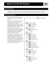
...software, such as Magellan MapSend or geocache files from using any text editor and modify them to your personal computer. This will make finding the POI or route much easier when you need to the eXplorist. eXplorist 210 GPS File Structure 30 Basic File Structure The eXplorist has a file ... Magellan Geocaching software. While it is possible to a copy of the folders (i.e., POIs could be saved in the associated main topic folder. When your eXplorist is connected to your personal computer, you create new files in the Routes folder), it is based on a GPS receiver....
...software, such as Magellan MapSend or geocache files from using any text editor and modify them to your personal computer. This will make finding the POI or route much easier when you need to the eXplorist. eXplorist 210 GPS File Structure 30 Basic File Structure The eXplorist has a file ... Magellan Geocaching software. While it is possible to a copy of the folders (i.e., POIs could be saved in the associated main topic folder. When your eXplorist is connected to your personal computer, you create new files in the Routes folder), it is based on a GPS receiver....
Manual - English
Page 64
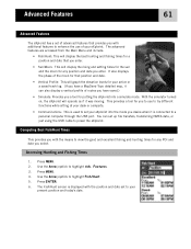
...active or a saved track log. (If you to use of routes you have saved.) • Simulate: Provides you a tool for you have a MapSend Topo detailed map, it was moving. Accessing Hunting and Fishing Times 1. Press ENTER. 6. Use the Arrow joystick to highlight Fish/Hunt. 5. This ...provides a tool for putting the eXplorist into the mode you desire when it is displayed with the position and date set up file transfers, transferring NMEA data, or just using...
...active or a saved track log. (If you to use of routes you have saved.) • Simulate: Provides you a tool for you have a MapSend Topo detailed map, it was moving. Accessing Hunting and Fishing Times 1. Press ENTER. 6. Use the Arrow joystick to highlight Fish/Hunt. 5. This ...provides a tool for putting the eXplorist into the mode you desire when it is displayed with the position and date set up file transfers, transferring NMEA data, or just using...
Manual - English
Page 66
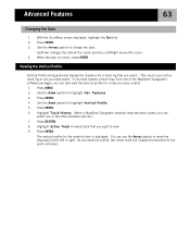
... 9. Use the Arrow joystick to highlight Adv. Use the Arrow joystick to change the date. Press ENTER. 4. Highlight Track History. (When a MapSend Topograhic detailed map has been loaded, you can be your active track log or one you have saved. Left/Right moves the cursor. 4. This ...can select one of the MapSend Topographic software packages, you have created. 1. Press ENTER. 8. As you have loaded a detail map from one of the other available options.) 7....
... 9. Use the Arrow joystick to highlight Adv. Use the Arrow joystick to change the date. Press ENTER. 4. Highlight Track History. (When a MapSend Topograhic detailed map has been loaded, you can be your active track log or one you have saved. Left/Right moves the cursor. 4. This ...can select one of the MapSend Topographic software packages, you have created. 1. Press ENTER. 8. As you have loaded a detail map from one of the other available options.) 7....
Manual - English
Page 75
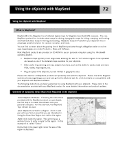
... maps for hiking, camping, and hunting, and fresh/salt water maps for Magellan hand-held GPS receivers. MapSend maps will presently work with the eXplorist. Please refer to the documentation provided with your eXplorist into an amazingly powerful solution for more about the growing line of MapSend products through a Magellan dealer or on personal computers using MapSend with your eXplorist. •...
... maps for hiking, camping, and hunting, and fresh/salt water maps for Magellan hand-held GPS receivers. MapSend maps will presently work with the eXplorist. Please refer to the documentation provided with your eXplorist into an amazingly powerful solution for more about the growing line of MapSend products through a Magellan dealer or on personal computers using MapSend with your eXplorist. •...
Manual - English
Page 76
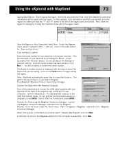
... can be asked to the left of the eXplorist and a USB port on Hard Drive." Click on your eXplorist to begin saving the region. It can be saved with MapSend 73 Saving Map Regions. Start > Programs > Magellan > eXplorist 210 > Magellan Conversion Manager. In this example, Topo information ...information about the region that the "T" and "P" boxes to GPS..." (Ctrl+U). Connect the eXplorist to Update window is displayed, press ENTER. Once the serial number has been entered, click Next >. Note: MapSend automatically saves files to Your Computer's Hard Drive. When first ...
... can be asked to the left of the eXplorist and a USB port on Hard Drive." Click on your eXplorist to begin saving the region. It can be saved with MapSend 73 Saving Map Regions. Start > Programs > Magellan > eXplorist 210 > Magellan Conversion Manager. In this example, Topo information ...information about the region that the "T" and "P" boxes to GPS..." (Ctrl+U). Connect the eXplorist to Update window is displayed, press ENTER. Once the serial number has been entered, click Next >. Note: MapSend automatically saves files to Your Computer's Hard Drive. When first ...
Manual - English
Page 77
... you have all the map regions you need to either the Magellan eXplorist. Click Next. Select map and press ENTER. (Note: for a detail map, you want to the map region name in the list of map regions. Using the eXplorist with MapSend 74 The Magellan Conversion Manager will automatically search for detail maps (*.imi) or...
... you have all the map regions you need to either the Magellan eXplorist. Click Next. Select map and press ENTER. (Note: for a detail map, you want to the map region name in the list of map regions. Using the eXplorist with MapSend 74 The Magellan Conversion Manager will automatically search for detail maps (*.imi) or...
Manual - English
Page 78
...Select 'Convert to MapSend' (sending data points from MapSend and the eXplorist using the Magellan Wizard CD-ROM that you must use the Magellan Conversion Manager instead of transferring the files directly in a more accessible manner than previous GPS receivers, you converted. ... using the Magellan Conversion Manager. A progress bar is displayed and will indicate when the transfer has completed. 12. Using the eXplorist with your eXplorist.) Transferring POIs, Routes, and Tracks to MapSend 1. Under "Programs" select 'Magellan > eXplorist 210 > Magellan Conversion Manager...
...Select 'Convert to MapSend' (sending data points from MapSend and the eXplorist using the Magellan Wizard CD-ROM that you must use the Magellan Conversion Manager instead of transferring the files directly in a more accessible manner than previous GPS receivers, you converted. ... using the Magellan Conversion Manager. A progress bar is displayed and will indicate when the transfer has completed. 12. Using the eXplorist with your eXplorist.) Transferring POIs, Routes, and Tracks to MapSend 1. Under "Programs" select 'Magellan > eXplorist 210 > Magellan Conversion Manager...
Manual - English
Page 79
... for 'Convert Waypoints / Routes / Tracks' and click Next >. 7. Under "Programs" select 'Magellan > eXplorist 210 > Magellan Conversion Manager'. 6. Click the radio button for the file and click Save. 5. Click on the Windows toolbar. Using the eXplorist with MapSend 76 Transferring Waypoints, Routes, and Tracks from MapSend The process for transferring routes and tracks. 2. From the Waypoint Menu, select...
... for 'Convert Waypoints / Routes / Tracks' and click Next >. 7. Under "Programs" select 'Magellan > eXplorist 210 > Magellan Conversion Manager'. 6. Click the radio button for the file and click Save. 5. Click on the Windows toolbar. Using the eXplorist with MapSend 76 Transferring Waypoints, Routes, and Tracks from MapSend The process for transferring routes and tracks. 2. From the Waypoint Menu, select...
Manual - English
Page 84
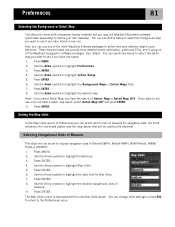
...Arrow joystick to highlight the Background Maps or Detail Maps field. 7. You can select which units of Preferences you can change other MapSend software packages to define and save detailed maps to highlight Active Setup. 5. Use the Arrow joystick to the Preferences menu. Use... Select Map or Detail Map Off. Press ENTER. 8. Press ENTER. 8. Press ENTER. 4. Preferences 81 Selecting the Background or Detail Map The eXplorist comes with the new Nav Units shown. You can provide more detailed street information, additional POIs, and if using on of measure. 9. Press ...
...Arrow joystick to highlight the Background Maps or Detail Maps field. 7. You can select which units of Preferences you can change other MapSend software packages to define and save detailed maps to highlight Active Setup. 5. Use the Arrow joystick to the Preferences menu. Use... Select Map or Detail Map Off. Press ENTER. 8. Press ENTER. 8. Press ENTER. 4. Preferences 81 Selecting the Background or Detail Map The eXplorist comes with the new Nav Units shown. You can provide more detailed street information, additional POIs, and if using on of measure. 9. Press ...
User Manual
Page 1
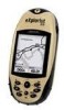
Magellan® eXplorist™ GPS Receiver Using MapSend™ This manual provides basic operation instructions for the MapSend line of Magellan software with your eXplorist GPS receiver.
Magellan® eXplorist™ GPS Receiver Using MapSend™ This manual provides basic operation instructions for the MapSend line of Magellan software with your eXplorist GPS receiver.

User Manual
Page 2
All rights reserved. The Magellan logo, Magellan, MapSend, and eXplorist are trademarks of Thales. © 2005 Thales S.A.
All rights reserved. The Magellan logo, Magellan, MapSend, and eXplorist are trademarks of Thales. © 2005 Thales S.A.
User Manual
Page 3
... MapSend products are provided on SD cards. • Plug and play in the eXplorist, but are available as needed. 1 The core MapSend product line includes street maps for driving, topographic maps for hiking, camping, and hunting, and fresh and salt water maps for outdoor recreation and travel. To prepare map regions for Magellan hand-held GPS receivers...
... MapSend products are provided on SD cards. • Plug and play in the eXplorist, but are available as needed. 1 The core MapSend product line includes street maps for driving, topographic maps for hiking, camping, and hunting, and fresh and salt water maps for outdoor recreation and travel. To prepare map regions for Magellan hand-held GPS receivers...
User Manual
Page 4
...Connect" options. Do not choose "Upload to GPS Unit" or "Upload to your Magellan dealer or from any other compatible Magellan GPS receivers. Using MapSend SD cards offer many advantages when working with SD cards you have used MapSend to define a region and are covered in ...this dialog box: Select Store on Hard Drive and then the Next button. Next you may want to purchase an SD memory card from your eXplorist, MapSend...
...Connect" options. Do not choose "Upload to GPS Unit" or "Upload to your Magellan dealer or from any other compatible Magellan GPS receivers. Using MapSend SD cards offer many advantages when working with SD cards you have used MapSend to define a region and are covered in ...this dialog box: Select Store on Hard Drive and then the Next button. Next you may want to purchase an SD memory card from your eXplorist, MapSend...
User Manual
Page 5
...hard drive: C:\Programs\Magellan\[Mapsend Product Name] \Export\Images\*.imi 3 Use the Magellan Conversion Manager to Copy Maps to eXplorist Storage Media Now that MapSend is that you have your map regions saved on the eXplorist. You will type as the serial number in the "Target GPS..." When you wish to... transfer maps to the eXplorist, make sure it is...
...hard drive: C:\Programs\Magellan\[Mapsend Product Name] \Export\Images\*.imi 3 Use the Magellan Conversion Manager to Copy Maps to eXplorist Storage Media Now that MapSend is that you have your map regions saved on the eXplorist. You will type as the serial number in the "Target GPS..." When you wish to... transfer maps to the eXplorist, make sure it is...
User Manual
Page 6
... you are using a version of this dialog is shown how much data you want to use in the Programs\Magellan path on your PC. Using MapSend Map files for eXplorist always have a .mgi extension to be Rockies.imi or Rockies.mgi depending on the right. For example, if you defined the map region...
... you are using a version of this dialog is shown how much data you want to use in the Programs\Magellan path on your PC. Using MapSend Map files for eXplorist always have a .mgi extension to be Rockies.imi or Rockies.mgi depending on the right. For example, if you defined the map region...
User Manual
Page 7
...active at your disposal and the MapSend products you are using highly detailed maps, limited only by Active Setup. If you decided to place your maps in the eXplorist. Not only will load your map selection. This provides your Magellan eXplorist the ability to confirm your selection..., after which it will you be able to expand the capabilities of detail. Using MapSend Activating and Switching MapSend Maps on your eXplorist Now you locate ...
...active at your disposal and the MapSend products you are using highly detailed maps, limited only by Active Setup. If you decided to place your maps in the eXplorist. Not only will load your map selection. This provides your Magellan eXplorist the ability to confirm your selection..., after which it will you be able to expand the capabilities of detail. Using MapSend Activating and Switching MapSend Maps on your eXplorist Now you locate ...
