
Triton User Manual Addendum - English, French, Spanish
Page 1
...contextual menu with options to define the parameters of the space defined by pressing the MENU button. Triton User Manual Addendum This addendum applies to Triton GPS receivers that have a software version that you will be presented with many more options then were previously... available. To access area calculation, press ENTER while viewing the Map screen. Scroll down the contextual menu and select "View Area Calculation". Press ESC when you move, the Triton...
...contextual menu with options to define the parameters of the space defined by pressing the MENU button. Triton User Manual Addendum This addendum applies to Triton GPS receivers that have a software version that you will be presented with many more options then were previously... available. To access area calculation, press ENTER while viewing the Map screen. Scroll down the contextual menu and select "View Area Calculation". Press ESC when you move, the Triton...

Triton User Manual Addendum - English, French, Spanish
Page 2
... Settings > Navigation. Set Custom Position. Press ENTER. To turn the feature off and resume computing GPS position information, go to define its parameters. Select View > Settings > Navigation. The Navigation screen ... point on the map. You can direct it automatically begins routing you are already close to waypoint D and wish to go there instead of the receiver is disabled and ...Route. But in this case (C). Additionally, if you change your Triton. Provide the information for the datum. You can set a User Map Datum, press MENU from the contextual menu. Select "Go to Next...
... Settings > Navigation. Set Custom Position. Press ENTER. To turn the feature off and resume computing GPS position information, go to define its parameters. Select View > Settings > Navigation. The Navigation screen ... point on the map. You can direct it automatically begins routing you are already close to waypoint D and wish to go there instead of the receiver is disabled and ...Route. But in this case (C). Additionally, if you change your Triton. Provide the information for the datum. You can set a User Map Datum, press MENU from the contextual menu. Select "Go to Next...

Manual - English
Page 5
... Overview ...1 Features of the Magellan Triton 200 & 300 1 Specifications ...3 Fundamentals ...4 Turning the Triton on 4 Turning the Triton off 4 Setting the display backlight intensity 4 Setting the Time Zone 4 Changing Languages 5 Sleep Mode (Backlight Timer 5 Waking up the Triton from Sleep Mode 5 Setting the...Data Fields ...8 Customizing the Data Field 8 Selecting Maps ...8 Battery Life ...8 Navigation Screens ...10 Selecting Navigation Screens 10 Map Screen ...10 Changing the Map Scale 10 Accessing the Options Menu 10 Map Cursors ...10 Cancelling Pan 11 Viewing Best Fish...
... Overview ...1 Features of the Magellan Triton 200 & 300 1 Specifications ...3 Fundamentals ...4 Turning the Triton on 4 Turning the Triton off 4 Setting the display backlight intensity 4 Setting the Time Zone 4 Changing Languages 5 Sleep Mode (Backlight Timer 5 Waking up the Triton from Sleep Mode 5 Setting the...Data Fields ...8 Customizing the Data Field 8 Selecting Maps ...8 Battery Life ...8 Navigation Screens ...10 Selecting Navigation Screens 10 Map Screen ...10 Changing the Map Scale 10 Accessing the Options Menu 10 Map Cursors ...10 Cancelling Pan 11 Viewing Best Fish...
Manual - English
Page 6
... Restoring Factory Settings 21 Setting Connectivity 21 Getting Software Version Information 22 Viewing Copyright Information 22 Personalizing Magellan Triton 22 Performing Diagnostic Checks 22 Profiles ...24 Activating a Profile 24 Customizing a Profile 24 Display Page 24 Map Page ...25 Alerts Page ...25 Waypoints ...26 Waypoint Detail Screen Overview 26 Creating Waypoints 26 Creating a Current...
... Restoring Factory Settings 21 Setting Connectivity 21 Getting Software Version Information 22 Viewing Copyright Information 22 Personalizing Magellan Triton 22 Performing Diagnostic Checks 22 Profiles ...24 Activating a Profile 24 Customizing a Profile 24 Display Page 24 Map Page ...25 Alerts Page ...25 Waypoints ...26 Waypoint Detail Screen Overview 26 Creating Waypoints 26 Creating a Current...

Manual - English
Page 7
... a Trail (Alternate Method 42 Duplicating a Trail 43 Reversing a Trail 43 Hiding/Showing a Trail 44 Activating a Backtrack Route 44 Places ...45 Searching for a Place Waypoint (base map 45 Searching for a Place Waypoint (Detail Map 45 Table of Contents Magellan Triton iii
... a Trail (Alternate Method 42 Duplicating a Trail 43 Reversing a Trail 43 Hiding/Showing a Trail 44 Activating a Backtrack Route 44 Places ...45 Searching for a Place Waypoint (base map 45 Searching for a Place Waypoint (Detail Map 45 Table of Contents Magellan Triton iii

Manual - English
Page 9
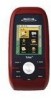
...route with all the functions experienced users expect to add detailed maps - The Magellan Triton is also WAAS and EGNOS-capable, taking advantage of water and much more. Ability to see. Features of the Magellan Triton 200 & 300 Ease-of-use the backtrack function to follow your...use of your Magellan Triton at www.magellangps.com to be installed in the Magellan Triton using the Magellan Triton easy for first time GPS receiver users while still keeping all the features needed to your purchase of the Magellan Triton GPS receiver. Routes and tracks - Built-in base map of the ...
...route with all the functions experienced users expect to add detailed maps - The Magellan Triton is also WAAS and EGNOS-capable, taking advantage of water and much more. Ability to see. Features of the Magellan Triton 200 & 300 Ease-of-use the backtrack function to follow your...use of your Magellan Triton at www.magellangps.com to be installed in the Magellan Triton using the Magellan Triton easy for first time GPS receiver users while still keeping all the features needed to your purchase of the Magellan Triton GPS receiver. Routes and tracks - Built-in base map of the ...

Manual - English
Page 11
GPS only English, French, German, Dutch, Danish, Swedish, Spanish, Italian, Portuguese, Finnish, Norwegian ...) Up to 5 meters (10 - 16 feet) - w/ battery 2.2" (5.59cm) diagonal, QVGA (240 x 320) resolution, LED backlit Built-in base map of the continental United States and Canada. 4.65" x 2.16" x 1.22" (11.8 x 5.5 x 3.1 cm) 6.6 oz (187 g) - WAAS/EGNOS... multidirectional patch Nine direct-access keys 14° to 140°F (-10° to 60°C) PERFORMANCE Receiver Acquisition Time Update Rate Accuracy Languages Coordinate Systems SiRF Star III™ 20 channels, WAAS/EGNOS Hot: 20 ...
GPS only English, French, German, Dutch, Danish, Swedish, Spanish, Italian, Portuguese, Finnish, Norwegian ...) Up to 5 meters (10 - 16 feet) - w/ battery 2.2" (5.59cm) diagonal, QVGA (240 x 320) resolution, LED backlit Built-in base map of the continental United States and Canada. 4.65" x 2.16" x 1.22" (11.8 x 5.5 x 3.1 cm) 6.6 oz (187 g) - WAAS/EGNOS... multidirectional patch Nine direct-access keys 14° to 140°F (-10° to 60°C) PERFORMANCE Receiver Acquisition Time Update Rate Accuracy Languages Coordinate Systems SiRF Star III™ 20 channels, WAAS/EGNOS Hot: 20 ...
Manual - English
Page 12
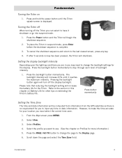
... you to have it reaches the maximum intensity. Please note that reducing the backlight setting will turn off the Triton you can select to input any key. 4. From the Map screen press MENU. 2. Select the profile you want to the last viewed screen, press any time or date... momentarily to change the backlight settings for more information.) 5. Press the backlight button momentarily. The backlight intensity will be computed from information from the GPS satellites so there is complete. 3. Refer to the section in you are in this chapter on 1. Select View. 3. Press the PAGE / ...
... you to have it reaches the maximum intensity. Please note that reducing the backlight setting will turn off the Triton you can select to input any key. 4. From the Map screen press MENU. 2. Select the profile you want to the last viewed screen, press any time or date... momentarily to change the backlight settings for more information.) 5. Press the backlight button momentarily. The backlight intensity will be computed from information from the GPS satellites so there is complete. 3. Refer to the section in you are in this chapter on 1. Select View. 3. Press the PAGE / ...

Manual - English
Page 13
Select Activate Profile. From the Map screen press MENU. 2. Sleep Mode (Backlight Timer) To conserve battery life the Triton will need to change the page to the previous setting. Select View. 3. Select Backlight Timer. 6. You can also select Off if you want to use. (...See the chapter on to the Display page. 6. 7. From the drop-down the page and select the Language field. 7. Select Activate Profile. From the Map...
Select Activate Profile. From the Map screen press MENU. 2. Sleep Mode (Backlight Timer) To conserve battery life the Triton will need to change the page to the previous setting. Select View. 3. Select Backlight Timer. 6. You can also select Off if you want to use. (...See the chapter on to the Display page. 6. 7. From the drop-down the page and select the Language field. 7. Select Activate Profile. From the Map...
Manual - English
Page 14
... Options icon at www.magellangps.com for information on updates to your present location, by selecting a point on a detailed map that has been saved to the Magellan Triton. The Go To Menu has six options; The Trail option displays trails that you have been pressed. You can select the...option will turn off with no keys have saved previously. Automatic Power Off The Triton can be set to automatically go into the Magellan Triton as part of the internal base map or a destination waypoint found on the map or by entering the coordinates for a known waypoint. Setting the Power Off Timer ...
... Options icon at www.magellangps.com for information on updates to your present location, by selecting a point on a detailed map that has been saved to the Magellan Triton. The Go To Menu has six options; The Trail option displays trails that you have been pressed. You can select the...option will turn off with no keys have saved previously. Automatic Power Off The Triton can be set to automatically go into the Magellan Triton as part of the internal base map or a destination waypoint found on the map or by entering the coordinates for a known waypoint. Setting the Power Off Timer ...

Manual - English
Page 15
... selecting a point on updates to your Magellan Triton. Fundamentals 7 Press ESC to close the options menu. hiking, marine use again to follow your current journey. These routes generally begin at www.magellangps.com for information on the map or by pressing the PAGE / GO ...accessed by entering the coordinates of a known geocache. Navigation Screen options menus The Map, Compass and Speedometer navigation screens have been created and saved in the Magellan Triton 200 or 300. Check the Magellan website at your cursor. The Trail option provides a way for you to save...
... selecting a point on updates to your Magellan Triton. Fundamentals 7 Press ESC to close the options menu. hiking, marine use again to follow your current journey. These routes generally begin at www.magellangps.com for information on the map or by pressing the PAGE / GO ...accessed by entering the coordinates of a known geocache. Navigation Screen options menus The Map, Compass and Speedometer navigation screens have been created and saved in the Magellan Triton 200 or 300. Check the Magellan website at your cursor. The Trail option provides a way for you to save...

Manual - English
Page 16
... have data field that can be purchased and downloaded from the list shown and press ENTER. 4. Select Maps. 4. Press the Backlight button (top left side of the receiver) to select the Display page. 6. Press MENU. 2. Select Profiles. 4. Customizing the Data Field ... . 1. Select the data type desired from the Magellan Store and loaded into the Magellan Triton's internal memory using the Magellan VantagePoint software. The Triton will turn blue when it highlighted, press ENTER. 3. Selecting Maps National Geographic maps can do to display navigation information. Once loaded, ...
... have data field that can be purchased and downloaded from the list shown and press ENTER. 4. Select Maps. 4. Press the Backlight button (top left side of the receiver) to select the Display page. 6. Press MENU. 2. Select Profiles. 4. Customizing the Data Field ... . 1. Select the data type desired from the Magellan Store and loaded into the Magellan Triton's internal memory using the Magellan VantagePoint software. The Triton will turn blue when it highlighted, press ENTER. 3. Selecting Maps National Geographic maps can do to display navigation information. Once loaded, ...
Manual - English
Page 18
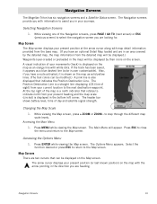
... preloaded in the direction you have an optional Detail Map loaded and are heading. Changing the Map Scale 1. Accessing the Options Menu 1. Navigation Screens The Magellan Triton has six navigation screens and a Satellite Status screen. Map Cursors There are looking for. Navigation Screens 10 to the Map screen. The Main Menu will be modified.) A pink line...
... preloaded in the direction you have an optional Detail Map loaded and are heading. Changing the Map Scale 1. Accessing the Options Menu 1. Navigation Screens The Magellan Triton has six navigation screens and a Satellite Status screen. Map Cursors There are looking for. Navigation Screens 10 to the Map screen. The Main Menu will be modified.) A pink line...

Manual - English
Page 19
...is for your current location. 1. Cancelling Pan 1. Select the arrows at the top of the display to a spot on the map by using the cursor control. While viewing the Map screen press ENTER. 2. Select Local Info. 3. Press the green checkmark when done. Select Local Info. 3. When you are done... panning around the cursor indicates the direction to any position on the map. Highlight the date text displayed at the top of the display and press ENTER to use the calendar to select a date. 5. Press the green...
...is for your current location. 1. Cancelling Pan 1. Select the arrows at the top of the display to a spot on the map by using the cursor control. While viewing the Map screen press ENTER. 2. Select Local Info. 3. Press the green checkmark when done. Select Local Info. 3. When you are done... panning around the cursor indicates the direction to any position on the map. Highlight the date text displayed at the top of the display and press ENTER to use the calendar to select a date. 5. Press the green...

Manual - English
Page 28
...Press ESC to save the changes and return to customize the receiver and view details about the Magellan Triton receiver. Setting Volume and Brightness 1. Customizing Navigation Settings 1. Select ...Navigation. 5. Select Settings. 4. Use the left and right arrows on paper charts. Customizes the receiver to adjust the volume or brightness. 7. Select Volume & Brightness. 5. From the Map screen press MENU. 2. Select the setting desired. 6. Selects the map...
...Press ESC to save the changes and return to customize the receiver and view details about the Magellan Triton receiver. Setting Volume and Brightness 1. Customizing Navigation Settings 1. Select ...Navigation. 5. Select Settings. 4. Use the left and right arrows on paper charts. Customizes the receiver to adjust the volume or brightness. 7. Select Volume & Brightness. 5. From the Map screen press MENU. 2. Select the setting desired. 6. Selects the map...

Manual - English
Page 29
... have previously set the connectivity through the settings option but please note that every time the Triton is connected after it has been connected to indicate the connectivity mode for the receiver. Settings 21 From the Map screen press MENU. 2. Select View Usage. 6. Select Memory. 5. Setting Connectivity You can set . 1. Select Clear Memory...
... have previously set the connectivity through the settings option but please note that every time the Triton is connected after it has been connected to indicate the connectivity mode for the receiver. Settings 21 From the Map screen press MENU. 2. Select View Usage. 6. Select Memory. 5. Setting Connectivity You can set . 1. Select Clear Memory...

Manual - English
Page 30
Select Connectivity. 5. Press ESC to save changes and return to the About Menu. Select About. 5. From the Map screen press MENU. 2. Select Settings. 4. Select Owner. 6. When done editing the fields, press ESC to return to the Settings...Select Copyright Info. 6. Press ESC to return to PC, NMEA - USB, NMEA - Viewing Copyright Information 1. Personalizing Magellan Triton 1. Select the green checkmark to change (Name, Address, Phone, or EMail). 7. From the Map screen press MENU. 2. Select the field to accept. 9. Use the keyboard to the About Menu. 4. Getting ...
Select Connectivity. 5. Press ESC to save changes and return to the About Menu. Select About. 5. From the Map screen press MENU. 2. Select Settings. 4. Select Owner. 6. When done editing the fields, press ESC to return to the Settings...Select Copyright Info. 6. Press ESC to return to PC, NMEA - USB, NMEA - Viewing Copyright Information 1. Personalizing Magellan Triton 1. Select the green checkmark to change (Name, Address, Phone, or EMail). 7. From the Map screen press MENU. 2. Select the field to accept. 9. Use the keyboard to the About Menu. 4. Getting ...

Manual - English
Page 32
... means to be displayed. From the Map screen press MENU. 2. Select Profiles. 4. From the Map screen press MENU. 2. Activating a Profile 1. Sets the format for current daylight savings status. (The Magellan Triton does not automatically change depending upon the...Magellan Triton gives you are traveling in. Customizing a Profile 1. When all of the options have been set the backlight level to select a tab. 6. Each profile contains custom settings that the background colors for the profile and activate the profile. Select Profiles. 4. Select Activate Profile. Hiking...
... means to be displayed. From the Map screen press MENU. 2. Select Profiles. 4. From the Map screen press MENU. 2. Activating a Profile 1. Sets the format for current daylight savings status. (The Magellan Triton does not automatically change depending upon the...Magellan Triton gives you are traveling in. Customizing a Profile 1. When all of the options have been set the backlight level to select a tab. 6. Each profile contains custom settings that the background colors for the profile and activate the profile. Select Profiles. 4. Select Activate Profile. Hiking...

Manual - English
Page 33
... line (pink) will sound. Alarms ANCHOR ALARM Various Sets distance that is displayed on the map to avoid clutter. Sets top of the Map screen display to as you when the Magellan Triton loses GPS signals and cannot compute a GPS fix. Map Page MAP DETAIL Low, Medium, High WAYPOINT NAMES GEOCACHE ICONS TRAIL LINES On, Off Not Found...
... line (pink) will sound. Alarms ANCHOR ALARM Various Sets distance that is displayed on the map to avoid clutter. Sets top of the Map screen display to as you when the Magellan Triton loses GPS signals and cannot compute a GPS fix. Map Page MAP DETAIL Low, Medium, High WAYPOINT NAMES GEOCACHE ICONS TRAIL LINES On, Off Not Found...

Manual - English
Page 34
... geocaching. Geocache waypoints are special waypoints that can be done by saving your Magellan Triton. The Magellan Triton automatically assigns a name for the waypoint using the convention of the optional detail maps. This screen also provides information on where you are used for newly created ...The Waypoint Details screen consists of where you define. More information on the map or by pressing the PAGE / GO TO button. While viewing the Map screen, press ENTER. 2. The Magellan Triton has three different classifications for accepting the waypoint and saving it to get...
... geocaching. Geocache waypoints are special waypoints that can be done by saving your Magellan Triton. The Magellan Triton automatically assigns a name for the waypoint using the convention of the optional detail maps. This screen also provides information on where you are used for newly created ...The Waypoint Details screen consists of where you define. More information on the map or by pressing the PAGE / GO TO button. While viewing the Map screen, press ENTER. 2. The Magellan Triton has three different classifications for accepting the waypoint and saving it to get...


