
Triton User Manual Addendum - English, French, Spanish
Page 1
...track. When you can pause and then resume recording your track. This will be presented with options to the saved track ("Trail"). The Triton receiver can set a user grid as the Coordinate System for the perimeter and area. Pause and Resume Active Track. The track Info screen ... of the space defined by pressing the MENU button. Scroll down the contextual menu and select "View Area Calculation". Triton User Manual Addendum This addendum applies to Triton GPS receivers that have a software version that you want to pause the recording of your track, press ENTER from any of ...
...track. When you can pause and then resume recording your track. This will be presented with options to the saved track ("Trail"). The Triton receiver can set a user grid as the Coordinate System for the perimeter and area. Pause and Resume Active Track. The track Info screen ... of the space defined by pressing the MENU button. Scroll down the contextual menu and select "View Area Calculation". Triton User Manual Addendum This addendum applies to Triton GPS receivers that have a software version that you want to pause the recording of your track, press ENTER from any of ...

Triton User Manual Addendum - English, French, Spanish
Page 2
... as the map datum. Set Custom Position provides a way to go there instead of the receiver is disabled and the screen is activated it to go to E. When you have an active...user-defined map datum for the datum. User Defined Map Datum. (Advanced Users) You can tell the Triton to go to the next destination (C) and repeat the process to go to the first leg destination (B).... select, either by entering the coordinates or by panning on the map. When setting a custom position, the GPS portion of the entire route. To view a custom position, step through the destinations in your active route....
... as the map datum. Set Custom Position provides a way to go there instead of the receiver is disabled and the screen is activated it to go to E. When you have an active...user-defined map datum for the datum. User Defined Map Datum. (Advanced Users) You can tell the Triton to go to the next destination (C) and repeat the process to go to the first leg destination (B).... select, either by entering the coordinates or by panning on the map. When setting a custom position, the GPS portion of the entire route. To view a custom position, step through the destinations in your active route....

Manual - English
Page 2
...The Magellan Triton is a navigation aid designed to assist you in injury or death to yourself or others could be reproduced or transmitted in any other than the purchaser's personal use of non-Magellan cables and antennas may severely degrade performance or damage the receiver, and... will void the warranty. USE PROPER ACCESSORIES Use only Magellan cables and antennas; Accuracy can result in an accident in accordance with Magellan Navigation GPS products (the "SOFTWARE") ...
...The Magellan Triton is a navigation aid designed to assist you in injury or death to yourself or others could be reproduced or transmitted in any other than the purchaser's personal use of non-Magellan cables and antennas may severely degrade performance or damage the receiver, and... will void the warranty. USE PROPER ACCESSORIES Use only Magellan cables and antennas; Accuracy can result in an accident in accordance with Magellan Navigation GPS products (the "SOFTWARE") ...

Manual - English
Page 9
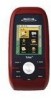
Features of the Magellan Triton 200 & 300 Ease-of-use of your point of origin. 3-meter accuracy - The Magellan Triton is also WAAS and EGNOS-capable, taking advantage of water and much more. The Magellan Triton was designed for the outdoor enthusiast with multiple destinations...footsteps back to be installed in the Magellan Triton using the Magellan Triton easy for first time GPS receiver users while still keeping all the features needed to register your Magellan Triton at www.magellangps.com/support/ and select your Magellan Triton model for additional information and tips on...
Features of the Magellan Triton 200 & 300 Ease-of-use of your point of origin. 3-meter accuracy - The Magellan Triton is also WAAS and EGNOS-capable, taking advantage of water and much more. The Magellan Triton was designed for the outdoor enthusiast with multiple destinations...footsteps back to be installed in the Magellan Triton using the Magellan Triton easy for first time GPS receiver users while still keeping all the features needed to register your Magellan Triton at www.magellangps.com/support/ and select your Magellan Triton model for additional information and tips on...

Manual - English
Page 11
WAAS/EGNOS, < 7 meters (15 feet) - GPS only English, French, German, Dutch, Danish, Swedish, Spanish, Italian, Portuguese, Finnish, Norwegian Latitude/Longitude, UTM, OSGB, Irish, Swish, Swedish, Finnish, German, French, USNG, MGRS, Indian, ...-resistant plastic, water-resistant seal, IPX-7 Built-in multidirectional patch Nine direct-access keys 14° to 140°F (-10° to 60°C) PERFORMANCE Receiver Acquisition Time Update Rate Accuracy Languages Coordinate Systems SiRF Star III™ 20 channels, WAAS/EGNOS Hot: 20 seconds, Cold: 60 seconds, Initial: 2 minutes Once...
WAAS/EGNOS, < 7 meters (15 feet) - GPS only English, French, German, Dutch, Danish, Swedish, Spanish, Italian, Portuguese, Finnish, Norwegian Latitude/Longitude, UTM, OSGB, Irish, Swish, Swedish, Finnish, German, French, USNG, MGRS, Indian, ...-resistant plastic, water-resistant seal, IPX-7 Built-in multidirectional patch Nine direct-access keys 14° to 140°F (-10° to 60°C) PERFORMANCE Receiver Acquisition Time Update Rate Accuracy Languages Coordinate Systems SiRF Star III™ 20 channels, WAAS/EGNOS Hot: 20 seconds, Cold: 60 seconds, Initial: 2 minutes Once...

Manual - English
Page 23
... measures (in proximity. This may decrease the accuracy (increase the number) such as heavy canopies from trees, tunnels, tall buildings, canyons, broadcast satellites, and other GPS receivers too close in distance) the progress the user has made . Accuracy Accuracy calculates the margin of day the user should be zero. Navigation Screens 15...
... measures (in proximity. This may decrease the accuracy (increase the number) such as heavy canopies from trees, tunnels, tall buildings, canyons, broadcast satellites, and other GPS receivers too close in distance) the progress the user has made . Accuracy Accuracy calculates the margin of day the user should be zero. Navigation Screens 15...

Manual - English
Page 52
... erased and you want to camp are displayed, if needed, or search for normal outdoor adventures, but also gives the traveller the security in a handheld GPS receiver. Select the order you plan on saving the track as the most important function in knowing that the backtrack has been started. Being able to...
... erased and you want to camp are displayed, if needed, or search for normal outdoor adventures, but also gives the traveller the security in a handheld GPS receiver. Select the order you plan on saving the track as the most important function in knowing that the backtrack has been started. Being able to...


