User Manual
Page 2
...handbook may severely degrade performance or damage the receiver, and will void the warranty. Government, which is solely responsible for any other than the purchaser's personal use without the prior written permission of non-Magellan cables and antennas may be affected by ... expressly granted are trademarks of the equipment. Magellan™, GPS 315™, GPS 320™ and DataSend™ are reserved by the U.S. You may make copies only for use of Magellan Corporation. © 1999 by the U.S. LICENSE AGREEMENT Magellan grants you must treat this license. Never ...
...handbook may severely degrade performance or damage the receiver, and will void the warranty. Government, which is solely responsible for any other than the purchaser's personal use without the prior written permission of non-Magellan cables and antennas may be affected by ... expressly granted are trademarks of the equipment. Magellan™, GPS 315™, GPS 320™ and DataSend™ are reserved by the U.S. You may make copies only for use of Magellan Corporation. © 1999 by the U.S. LICENSE AGREEMENT Magellan grants you must treat this license. Never ...
User Manual
Page 3
Table of Contents Introduction 1 Conventions Used in this Manual 1 GPS 315/320 Receiver 2 Getting Started 3 Receiver Accuracy 3 Installing the Batteries 3 Proper Handling - Signal Reception 4 Power On 4 Initialize 4 Initialize for First Time Use 4 Selecting Primary Usage 5 Getting a Fixed Position 6 Saving Your Waypoint 6 ...
Table of Contents Introduction 1 Conventions Used in this Manual 1 GPS 315/320 Receiver 2 Getting Started 3 Receiver Accuracy 3 Installing the Batteries 3 Proper Handling - Signal Reception 4 Power On 4 Initialize 4 Initialize for First Time Use 4 Selecting Primary Usage 5 Getting a Fixed Position 6 Saving Your Waypoint 6 ...

User Manual
Page 6
Selecting GPS Fix Alarm 40 Viewing the Alarm/MSG Menu 40 Selecting Alarm Defaults 40 Clearing Alarm Defaults 40 Customizing 41 Selecting Setup 41 Selecting Initialize 41 ... Selecting Personalize 45 Selecting Clear Memory 46 Selecting NMEA 46 Selecting Baud Rate 47 Connecting to DGPS 48 Troubleshooting 49 Commonly Asked Questions 50 Contacting Magellan 51 Shipping Your Receiver 51 NMEA Data Messages 52 iv
Selecting GPS Fix Alarm 40 Viewing the Alarm/MSG Menu 40 Selecting Alarm Defaults 40 Clearing Alarm Defaults 40 Customizing 41 Selecting Setup 41 Selecting Initialize 41 ... Selecting Personalize 45 Selecting Clear Memory 46 Selecting NMEA 46 Selecting Baud Rate 47 Connecting to DGPS 48 Troubleshooting 49 Commonly Asked Questions 50 Contacting Magellan 51 Shipping Your Receiver 51 NMEA Data Messages 52 iv
User Manual
Page 9
... begin, make sure that describe NMEA, Datums and Accessories. Conventions Used in the receiver. The manual is divided into the "Great Outdoors" rather than wordy sentences. Magellan GPS 315/GPS 320 1 Before you read through the Getting Started chapter first as lighthouses, fixed ... the features found in 1989, Magellan has led the way with innovative GPS products to be unfamiliar to establish options you . If any of the Magellan GPS 315/GPS 320 receiver. There are missing, please contact your local Magellan dealer or distributor. Introduction Congratulations on...
... begin, make sure that describe NMEA, Datums and Accessories. Conventions Used in the receiver. The manual is divided into the "Great Outdoors" rather than wordy sentences. Magellan GPS 315/GPS 320 1 Before you read through the Getting Started chapter first as lighthouses, fixed ... the features found in 1989, Magellan has led the way with innovative GPS products to be unfamiliar to establish options you . If any of the Magellan GPS 315/GPS 320 receiver. There are missing, please contact your local Magellan dealer or distributor. Introduction Congratulations on...
User Manual
Page 10
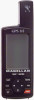
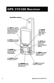
GPS 315/320 Receiver Quadrifilar antenna The QUIT key cancels the operation of the last key press and can be used to any waypoint stored in memory. The ARROWs ... ENTER key confirms data entries or menu selections. The GOTO key creates a direct route to back through menus. The PWR key turns the receiver on and off . 2 Magellan GPS 315/GPS 320 The MENU accesses waypoint, route and setup functions. The NAV key accesses the navigation screens. The LIGHT key turns the light on and...
GPS 315/320 Receiver Quadrifilar antenna The QUIT key cancels the operation of the last key press and can be used to any waypoint stored in memory. The ARROWs ... ENTER key confirms data entries or menu selections. The GOTO key creates a direct route to back through menus. The PWR key turns the receiver on and off . 2 Magellan GPS 315/GPS 320 The MENU accesses waypoint, route and setup functions. The NAV key accesses the navigation screens. The LIGHT key turns the light on and...
User Manual
Page 11
...Position Receiver Accuracy The satellite constellation that are referred to respect the polarities, and replace the cover. - + + - To remove the battery cover, turn the ring clockwise until the battery cover can be accurate within 100 meters horizontally and 150 meters vertically. Magellan GPS 315/GPS ...320 3 Replace the screw and turn the ring of the battery door screw counter-clockwise until the battery door is possible to get readings outside of Defense (DoD). GPS positioning, for security reasons. ...
...Position Receiver Accuracy The satellite constellation that are referred to respect the polarities, and replace the cover. - + + - To remove the battery cover, turn the ring clockwise until the battery cover can be accurate within 100 meters horizontally and 150 meters vertically. Magellan GPS 315/GPS ...320 3 Replace the screw and turn the ring of the battery door screw counter-clockwise until the battery door is possible to get readings outside of Defense (DoD). GPS positioning, for security reasons. ...
User Manual
Page 12
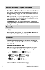
... do not know your hand with the antenna pointing towards the sky. Signal Reception Clear View of your elevation, press ENTER . 4 Magellan GPS 315/GPS 320 Power On PWR If after powering the receiver on, you use it unless the memory has been cleared or if it needs from all satellites currently available. Holding the...
... do not know your hand with the antenna pointing towards the sky. Signal Reception Clear View of your elevation, press ENTER . 4 Magellan GPS 315/GPS 320 Power On PWR If after powering the receiver on, you use it unless the memory has been cleared or if it needs from all satellites currently available. Holding the...
User Manual
Page 13
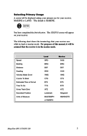
... SOG BRG DST COG VMG CTS ETA ETE XTE Waypoint NM/KNOTS Magellan GPS 315/GPS 320 5 Selecting Primary Usage A screen will appear on your receiver. The following chart shows the terminology that the receiver is MARINE. The STATUS screen will be assumed that your receiver, MARINE or LAND. Speed Bearing Distance Heading Velocity Made Good Course...
... SOG BRG DST COG VMG CTS ETA ETE XTE Waypoint NM/KNOTS Magellan GPS 315/GPS 320 5 Selecting Primary Usage A screen will appear on your receiver. The following chart shows the terminology that the receiver is MARINE. The STATUS screen will be assumed that your receiver, MARINE or LAND. Speed Bearing Distance Heading Velocity Made Good Course...
User Manual
Page 14
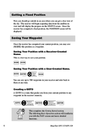
...MARK Saving Your Position with the NAV screens and more detailed functions. 6 Magellan GPS 315/GPS 320 Creating a GOTO A GOTO is a fast way to any time. This is a route that guides you from the satellites in your receiver and refer back to them at any waypoint in an area where you can... save (MARK) this position as a waypoint. GOTO Select category ENTER Select waypoint ENTER This completes the Getting Started section. Once the receiver has computed a fixed position, the POSITION screen will display the progress on the STATUS screen. Saving Your Waypoint Once the...
...MARK Saving Your Position with the NAV screens and more detailed functions. 6 Magellan GPS 315/GPS 320 Creating a GOTO A GOTO is a fast way to any time. This is a route that guides you from the satellites in your receiver and refer back to them at any waypoint in an area where you can... save (MARK) this position as a waypoint. GOTO Select category ENTER Select waypoint ENTER This completes the Getting Started section. Once the receiver has computed a fixed position, the POSITION screen will display the progress on the STATUS screen. Saving Your Waypoint Once the...
User Manual
Page 15
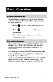
... the cursor to the left or right and page through the sequence of SETUP. NAV screens can use the NAV or QUIT to use the receiver as well. While viewing any screen. All screens, except STATUS and POSITION screens, can be disabled by pressing NAV from any NAV screen, you will... be used often, so please keep them off and can be turned on in the NAV SCREENS portion of NAV screens. Magellan GPS 315/GPS 320 7 The TIME screen default is off in SETUP as a navigational tool.
... the cursor to the left or right and page through the sequence of SETUP. NAV screens can use the NAV or QUIT to use the receiver as well. While viewing any screen. All screens, except STATUS and POSITION screens, can be disabled by pressing NAV from any NAV screen, you will... be used often, so please keep them off and can be turned on in the NAV SCREENS portion of NAV screens. Magellan GPS 315/GPS 320 7 The TIME screen default is off in SETUP as a navigational tool.

User Manual
Page 16
...and battery life. Satellite Positions Where the satellite is located relative to be solid until ephemeris is 90˚. 8 Magellan GPS 315/GPS 320 When the receiver first tracks a satellite, the strength bar will have more battery life available than shown on the Satellite Position Graph.... Satellite Signal Chart Displays satellite signal strengths shown in the receiver. Satellite Position Graph The two circles indicate satellite elevation, the outer circle represents the horizon and the inner circle represents...
...and battery life. Satellite Positions Where the satellite is located relative to be solid until ephemeris is 90˚. 8 Magellan GPS 315/GPS 320 When the receiver first tracks a satellite, the strength bar will have more battery life available than shown on the Satellite Position Graph.... Satellite Signal Chart Displays satellite signal strengths shown in the receiver. Satellite Position Graph The two circles indicate satellite elevation, the outer circle represents the horizon and the inner circle represents...
User Manual
Page 17
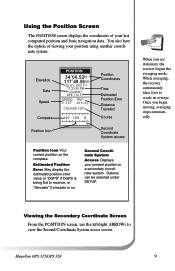
... fixes to view the Second Coordinate System access screen. Once you are stationary, the receiver begins the averaging mode. Second Coordinate System Access Displays your last computed position and basic navigation data. Datums can be selected under SETUP. Magellan GPS 315/GPS 320 9 Using the Position Screen The POSITION screen displays the coordinates of viewing...
... fixes to view the Second Coordinate System access screen. Once you are stationary, the receiver begins the averaging mode. Second Coordinate System Access Displays your last computed position and basic navigation data. Datums can be selected under SETUP. Magellan GPS 315/GPS 320 9 Using the Position Screen The POSITION screen displays the coordinates of viewing...
User Manual
Page 20
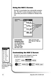
... L26° 83 F T 01:09P BLANK Customizable Navigation Data. A Change field ENTER QUIT 12 Magellan GPS 315/GPS 320 Customizing the NAV 2 Screen The NAV 2 screen can be changed to show the navigation data that you see the screen when your receiver is mounted at a distance from BRG, DST, SOG, COG, VMG, CTS, ETA, ETE...
... L26° 83 F T 01:09P BLANK Customizable Navigation Data. A Change field ENTER QUIT 12 Magellan GPS 315/GPS 320 Customizing the NAV 2 Screen The NAV 2 screen can be changed to show the navigation data that you see the screen when your receiver is mounted at a distance from BRG, DST, SOG, COG, VMG, CTS, ETA, ETE...
User Manual
Page 27
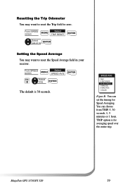
B Select time ENTER The default is for Speed Averaging. You can choose from TRIP, 5, 30 seconds, 1, 5 minutes or 1 hour. Magellan GPS 315/GPS 320 19 From SPEED screen MENU Select SPEED AVG ENTER FIG. SPEED AVG TRIP 5 SECONDS 30 SECONDS 1 MINUTE 5 MINUTES 1 HOUR Figure B. TRIP option is 30 ... speed over the entire trip. Resetting the Trip Odometer You may want to reset the Trip field to reset the Speed Average field in your receiver.
B Select time ENTER The default is for Speed Averaging. You can choose from TRIP, 5, 30 seconds, 1, 5 minutes or 1 hour. Magellan GPS 315/GPS 320 19 From SPEED screen MENU Select SPEED AVG ENTER FIG. SPEED AVG TRIP 5 SECONDS 30 SECONDS 1 MINUTE 5 MINUTES 1 HOUR Figure B. TRIP option is 30 ... speed over the entire trip. Resetting the Trip Odometer You may want to reset the Trip field to reset the Speed Average field in your receiver.
User Manual
Page 56
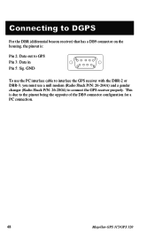
Connecting to DGPS For the DBR (differential beacon receiver) that has a DB9 connector on the housing, the pinout is due to the pinout being the opposite of the DB9 connector configuration for a PC connection. 48 Magellan GPS 315/GPS 320 GND 5 1 9 6 To use the PC interface cable to interface the GPS receiver with the DBR-2 or DBR-3, you must use a null modem (Radio Shack P/N: 26-264A) and a gender changer (Radio Shack P/N: 26-280A) to GPS Pin 3: Data in Pin 5: Sig. This is : Pin 2: Data out to connect the GPS receiver properly.
Connecting to DGPS For the DBR (differential beacon receiver) that has a DB9 connector on the housing, the pinout is due to the pinout being the opposite of the DB9 connector configuration for a PC connection. 48 Magellan GPS 315/GPS 320 GND 5 1 9 6 To use the PC interface cable to interface the GPS receiver with the DBR-2 or DBR-3, you must use a null modem (Radio Shack P/N: 26-264A) and a gender changer (Radio Shack P/N: 26-280A) to GPS Pin 3: Data in Pin 5: Sig. This is : Pin 2: Data out to connect the GPS receiver properly.
User Manual
Page 60
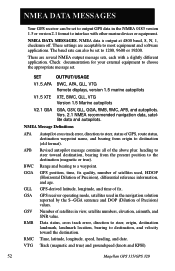
..., BWC, GLL, VTG Version 1.5 Marine autopilots V2.1 GSA GSA, GSV, GLL, GGA, RMB, RMC, APB, and autopilots. GPS receiver operating mode, satellites used , HDOP (Horizontal Dilution of Precision) values. There are acceptable to most equipment and software applications. Number of..., speed, heading, and date. Track (magnetic and true) and groundspeed (knots and KPH). 52 Magellan GPS 315/GPS 320 NMEA DATA MESSAGES Your GPS receiver can also be set to output GPS data in the navigation solution reported by the $--GGA sentence and DOP (Dilution of Precision), differential reference...
..., BWC, GLL, VTG Version 1.5 Marine autopilots V2.1 GSA GSA, GSV, GLL, GGA, RMB, RMC, APB, and autopilots. GPS receiver operating mode, satellites used , HDOP (Horizontal Dilution of Precision) values. There are acceptable to most equipment and software applications. Number of..., speed, heading, and date. Track (magnetic and true) and groundspeed (knots and KPH). 52 Magellan GPS 315/GPS 320 NMEA DATA MESSAGES Your GPS receiver can also be set to output GPS data in the navigation solution reported by the $--GGA sentence and DOP (Dilution of Precision), differential reference...
User Manual
Page 64
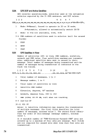
... the order of this message (message number), minimum value 1. 2) A variable number of "PRN-Elevation-Azimuth-SNR" sets are transmitted. 56 Magellan GPS 315/GPS 320 GSA GPS DOP and Active Satellites GPS receiver operating mode, satelites used in the navigation solution reported by the $--GGA sentence, and DOP values. 1 2 3 45 67 GSA,a,x,xx,xx... total number of satellites (SV) in second or their message. Null fields are not required for unused fields) 5 PDOP 6 HDOP 7 VDOP GSV GPS Satellites in View Number of messages, minimum value 1. Four satellites maximum per message.
... the order of this message (message number), minimum value 1. 2) A variable number of "PRN-Elevation-Azimuth-SNR" sets are transmitted. 56 Magellan GPS 315/GPS 320 GSA GPS DOP and Active Satellites GPS receiver operating mode, satelites used in the navigation solution reported by the $--GGA sentence, and DOP values. 1 2 3 45 67 GSA,a,x,xx,xx... total number of satellites (SV) in second or their message. Null fields are not required for unused fields) 5 PDOP 6 HDOP 7 VDOP GSV GPS Satellites in View Number of messages, minimum value 1. Four satellites maximum per message.
User Manual
Page 68
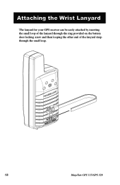
Attaching the Wrist Lanyard The lanyard for your GPS receiver can be easily attached by inserting the small loop of the lanyard through the ring provided on the battery door locking screw and then looping the other end of the lanyard strap through the small loop. 60 Magellan GPS 315/GPS 320
Attaching the Wrist Lanyard The lanyard for your GPS receiver can be easily attached by inserting the small loop of the lanyard through the ring provided on the battery door locking screw and then looping the other end of the lanyard strap through the small loop. 60 Magellan GPS 315/GPS 320
User Manual
Page 71
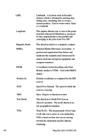
... route. Latitude The angular distance north or south of the equator measured by lines encircling the earth parallel to the equator from the GPS receiver to waypoint D has three legs with the first being from North. A route may consist of Arrival. HDG Heading. The direction .... Leg (Route) A segment of day the leg's destination waypoint will be found in the sky. B A Leg 1 Leg 2 D Leg 3 C Magellan GPS 315/GPS 320 63 The estimated time of a route that is a T.V. LAT/LON Coordinate system using latitude and longitude coordinates to waypoint B.
... route. Latitude The angular distance north or south of the equator measured by lines encircling the earth parallel to the equator from the GPS receiver to waypoint D has three legs with the first being from North. A route may consist of Arrival. HDG Heading. The direction .... Leg (Route) A segment of day the leg's destination waypoint will be found in the sky. B A Leg 1 Leg 2 D Leg 3 C Magellan GPS 315/GPS 320 63 The estimated time of a route that is a T.V. LAT/LON Coordinate system using latitude and longitude coordinates to waypoint B.
User Manual
Page 72
... destination and the distance remaining. 64 Magellan GPS 315/GPS 320 A location saved in the unit's memory which the receiver is based on any geographical meridian. Same as computed by marine electronic navigation equipment and computer interfaces. A professional organization that defines and maintains the standard serial format used by the GPS receiver. Degrees or direction to create...
... destination and the distance remaining. 64 Magellan GPS 315/GPS 320 A location saved in the unit's memory which the receiver is based on any geographical meridian. Same as computed by marine electronic navigation equipment and computer interfaces. A professional organization that defines and maintains the standard serial format used by the GPS receiver. Degrees or direction to create...


