StructureMap Guide
Page 1
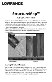
Same structure shown in each panel StructureMap SideScan Viewing StructureMap data You can view StructureMap data by using the Overlay softkey (HDS-8/10). StructureMap data will start to appear on Structure overlay from the Chart menu, or by turning on the Chart ... environment in interpreting sidescan sonar images. Refer to your position and aids the user in relation to your HDS manual for basic information about StructureScan. Refer to your boat. StructureMap™ HDS Gen 2 Addendum StructureMap is a tool that allows you to overlay SideScan sonar returns on top of the...
Same structure shown in each panel StructureMap SideScan Viewing StructureMap data You can view StructureMap data by using the Overlay softkey (HDS-8/10). StructureMap data will start to appear on Structure overlay from the Chart menu, or by turning on the Chart ... environment in interpreting sidescan sonar images. Refer to your position and aids the user in relation to your HDS manual for basic information about StructureScan. Refer to your boat. StructureMap™ HDS Gen 2 Addendum StructureMap is a tool that allows you to overlay SideScan sonar returns on top of the...
StructureMap Guide
Page 4
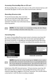
... a structure sonar log (.sl2). We recommend using an SD card for recording when possible, due to the Converts sonar log files to structuremap format Manual conversion Automatic conversion NOTE: Keep the size of your sonar logs to 100MB or less to allow for more information about sonar log options. limited... size of the HDS internal memory. Converting files To create a StructureMap file you must convert a structure sonar log (.sl2) file to map when complete on the Sonar ...
... a structure sonar log (.sl2). We recommend using an SD card for recording when possible, due to the Converts sonar log files to structuremap format Manual conversion Automatic conversion NOTE: Keep the size of your sonar logs to 100MB or less to allow for more information about sonar log options. limited... size of the HDS internal memory. Converting files To create a StructureMap file you must convert a structure sonar log (.sl2) file to map when complete on the Sonar ...
StructureMap Guide
Page 6
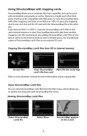
... the StructureMap (.smf ) files to the units internal memory to view StructureMap data with HDS units. Viewing StructureMap (.smf) files Select StructureMap (.smf) file Select Show StructureMap appears on an HDS-8 or HDS-10, place the mapping card in one lake at a time to the internal memory due...cards StructureMap allows you to maintain full chart capability and can view StructureMap (.smf ) files from card Refer to your operation manual for more information about copying files. We recommend only adding StructureMap (.smf ) files of StructureMap (.smf ) files on an external SD card....
... the StructureMap (.smf ) files to the units internal memory to view StructureMap data with HDS units. Viewing StructureMap (.smf) files Select StructureMap (.smf) file Select Show StructureMap appears on an HDS-8 or HDS-10, place the mapping card in one lake at a time to the internal memory due...cards StructureMap allows you to maintain full chart capability and can view StructureMap (.smf ) files from card Refer to your operation manual for more information about copying files. We recommend only adding StructureMap (.smf ) files of StructureMap (.smf ) files on an external SD card....

Installation Manual
Page 1
HDS Series Installation manual
HDS Series Installation manual
Installation Manual
Page 2
... As Navico is continuously improving this product, we retain the right to make changes to install and use the instrument and transducers in this manual to the following address: [email protected] Warranty • The warranty card is the owner's sole responsibility to specifications without notice. ...important and helps Navico ensure that will be reflected in a manner that this product is solely responsible for all marine technicians. www.lowrance.com 1 It is supplied as at any time which may be translated to, or has been translated from you require any further assistance....
... As Navico is continuously improving this product, we retain the right to make changes to install and use the instrument and transducers in this manual to the following address: [email protected] Warranty • The warranty card is the owner's sole responsibility to specifications without notice. ...important and helps Navico ensure that will be reflected in a manner that this product is solely responsible for all marine technicians. www.lowrance.com 1 It is supplied as at any time which may be translated to, or has been translated from you require any further assistance....
Installation Manual
Page 4
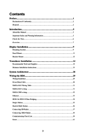
... About this Manual...5 Important Safety and Warning Information 5 Check the Parts...6 Overview...7 Display Installation 9 Mounting location...9 Panel Mount...11 Bracket Mount...12 Transducer Installation 14 Recommended Tools and Supplies 14 Skimmer Installation Instructions 15 System Architecture 28 Wiring the HDS 29 Wiring ...Guidelines...29 Power/Data Cable...30 NMEA 0183 Wiring Table 31 NMEA 0183 wiring ...31 NMEA 2000 wiring...32 Ethernet...33 HDS-8 & HDS-10 Data Bridging 34 Single Station...35 Dual...
... About this Manual...5 Important Safety and Warning Information 5 Check the Parts...6 Overview...7 Display Installation 9 Mounting location...9 Panel Mount...11 Bracket Mount...12 Transducer Installation 14 Recommended Tools and Supplies 14 Skimmer Installation Instructions 15 System Architecture 28 Wiring the HDS 29 Wiring ...Guidelines...29 Power/Data Cable...30 NMEA 0183 Wiring Table 31 NMEA 0183 wiring ...31 NMEA 2000 wiring...32 Ethernet...33 HDS-8 & HDS-10 Data Bridging 34 Single Station...35 Dual...
Installation Manual
Page 6
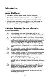
.... The Global Positioning System (GPS) is operated by the Lowrance HDS with imperial (non-metric) units only. The accuracy of the Sonar depth display can not be liable for changes between the product and the manual. For full use . Refer to the constant improvement of... such as a navigational aid. Introduction About this Manual • This manual is a reference guide for installing a Lowrance HDS System. • The information in this manual at the time of printing is used correctly. When navigating the vessel, use the Lowrance HDS system only as when you are moored in a...
.... The Global Positioning System (GPS) is operated by the Lowrance HDS with imperial (non-metric) units only. The accuracy of the Sonar depth display can not be liable for changes between the product and the manual. For full use . Refer to the constant improvement of... such as a navigational aid. Introduction About this Manual • This manual is a reference guide for installing a Lowrance HDS System. • The information in this manual at the time of printing is used correctly. When navigating the vessel, use the Lowrance HDS system only as when you are moored in a...
Installation Manual
Page 7
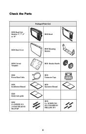
Check the Parts HDS Head Unit Models: 5", 7", 8" or 10" Packaged Parts List ISO 30 Degree with Perspective HDS Bezel HDS Dust Cover HDS Mounting Bracket HDS Cut-out Template HDS Power/Data Cable HDS Installation Manual HDS Quick start guide HDS 4 x SCREW #10 3/4 PAN HEAD SS SELFTAP HDS Bracket Knobs HDS Connector Caps HDS Operation Manual HDS 4 x SCREW NO. 6X1.5 PANHEAD PHILLIPS TP1 6
Check the Parts HDS Head Unit Models: 5", 7", 8" or 10" Packaged Parts List ISO 30 Degree with Perspective HDS Bezel HDS Dust Cover HDS Mounting Bracket HDS Cut-out Template HDS Power/Data Cable HDS Installation Manual HDS Quick start guide HDS 4 x SCREW #10 3/4 PAN HEAD SS SELFTAP HDS Bracket Knobs HDS Connector Caps HDS Operation Manual HDS 4 x SCREW NO. 6X1.5 PANHEAD PHILLIPS TP1 6
Installation Manual
Page 10
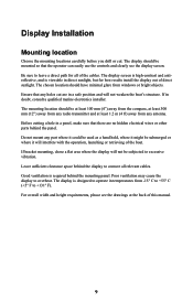
..., and is viewable in temperatures from any antenna. Good ventilation is designed to leave a direct path for best results install the display out of this manual. 9 Before cutting a hole in doubt, consult a qualified marine electronics installer. Poor ventilation may cause the display to excessive vibration. The chosen location should be subjected...
..., and is viewable in temperatures from any antenna. Good ventilation is designed to leave a direct path for best results install the display out of this manual. 9 Before cutting a hole in doubt, consult a qualified marine electronics installer. Poor ventilation may cause the display to excessive vibration. The chosen location should be subjected...

Installation Manual
Page 35
.../sentences) are bridged (converted) to NMEA2000 and distributed on the Lowrance backbone for all other displays to use. HDS-8 & HDS-10 Data Bridging Supported NMEA0183 sentences entering the system are bridged across to NMEA0183 to be available as an output from any HDS display. HDS HDS N2K 0183 B N2K Power / Data cable NMEA 2K NMEA 2K... (+) BLUE TX (-) Orange (RX+) Green (RX-) Shield (ground) NMEA0183 Listner C NMEA 2K Network 34 Refer to the NMEA 0183 table in the back of this manual to view bridgable sentences.
.../sentences) are bridged (converted) to NMEA2000 and distributed on the Lowrance backbone for all other displays to use. HDS-8 & HDS-10 Data Bridging Supported NMEA0183 sentences entering the system are bridged across to NMEA0183 to be available as an output from any HDS display. HDS HDS N2K 0183 B N2K Power / Data cable NMEA 2K NMEA 2K... (+) BLUE TX (-) Orange (RX+) Green (RX-) Shield (ground) NMEA0183 Listner C NMEA 2K Network 34 Refer to the NMEA 0183 table in the back of this manual to view bridgable sentences.
Installation Manual
Page 38
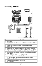
... and 10 m, (6.5, 16.5 & 33 ft) F Ethernet Adapter cable. See radar installation manual for HDS. G HDS and Radar Power. Make sure a fuse is available D HD Radar Processor E Ethernet cable RJ45 (male/male). Connecting HD Radar 12 V DC ONLY Scanner D Ethernet HEADING In A B C D F E ...NMEA0183 converter. (24006694) J RC42 Compass (Heading) K SimNet to NMEA2000 adapter kit (000-0127-45) L NMEA 2000 Backbone 37 B LRA1800 &LRA2400 HD radar system for radar fuse size H Optional NEP (Network Expansion port) (000-0132-031) For Chart overlay or MARPA the following are required: I...
... and 10 m, (6.5, 16.5 & 33 ft) F Ethernet Adapter cable. See radar installation manual for HDS. G HDS and Radar Power. Make sure a fuse is available D HD Radar Processor E Ethernet cable RJ45 (male/male). Connecting HD Radar 12 V DC ONLY Scanner D Ethernet HEADING In A B C D F E ...NMEA0183 converter. (24006694) J RC42 Compass (Heading) K SimNet to NMEA2000 adapter kit (000-0127-45) L NMEA 2000 Backbone 37 B LRA1800 &LRA2400 HD radar system for radar fuse size H Optional NEP (Network Expansion port) (000-0132-031) For Chart overlay or MARPA the following are required: I...
Installation Manual
Page 42
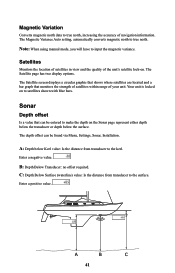
C: Depth Below Surface (waterline) value: Is the distance from transducer to true north. A B C 41 Note: When using manual mode, you will have to the surface. The depth offset can be found via Menu, Settings, Sonar, Installation. A: Depth below the surface. Enter a positive value. ...
C: Depth Below Surface (waterline) value: Is the distance from transducer to true north. A B C 41 Note: When using manual mode, you will have to the surface. The depth offset can be found via Menu, Settings, Sonar, Installation. A: Depth below the surface. Enter a positive value. ...
Installation Manual
Page 43
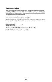
... can be performed with ability to calibrate to +/-20%. 42 Select Auto correct to match water speed to 117%. Increase the offset to ground speed Manual calculation. The calculation is 100 % with as little wind and current movement as possible. If in speed Paddle wheel speed x 100. Default is : Difference in...
... can be performed with ability to calibrate to +/-20%. 42 Select Auto correct to match water speed to 117%. Increase the offset to ground speed Manual calculation. The calculation is 100 % with as little wind and current movement as possible. If in speed Paddle wheel speed x 100. Default is : Difference in...
HDS Gen2 2.5 software release addendum - EN
Page 1
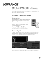
Press the Power and Pages keys simultaneously to convert files in the HDS Gen2 Operation manual. StructureMap HD You can create standard or high resolution StructureMap .smf files. Check the High Resolution checkbox to take longer to enable... internal memory without having to convert and are not described in high detail. | 1 HDS Gen2 2.0 software update Screen capture A new method for taking screen captures has been implemented in the HDS Gen2 2.0 and 2.5 software updates. HDS Gen2 RTM 2.0 & 2.5 addendum This addendum documents new features included in this software version. ...
Press the Power and Pages keys simultaneously to convert files in the HDS Gen2 Operation manual. StructureMap HD You can create standard or high resolution StructureMap .smf files. Check the High Resolution checkbox to take longer to enable... internal memory without having to convert and are not described in high detail. | 1 HDS Gen2 2.0 software update Screen capture A new method for taking screen captures has been implemented in the HDS Gen2 2.0 and 2.5 software updates. HDS Gen2 RTM 2.0 & 2.5 addendum This addendum documents new features included in this software version. ...

HDS Gen2 2.5 software release addendum - EN
Page 3
This includes Dynamic tides and currents, Easy view, Depth highlighting range, Shallow water highlighting and Rock filtering. • Dynamic tides and currents - Select Change to Lowrance or Change to be highlighted. New Navionics features The 2.0 software update has several new Navionics features that allow the user to customize their on the ... levels • Easy view - Select Chart options 3. Press Enter. Selecting chart data The method for selecting chart data has changed since the most recent operation manual release. 1. Access the Chart menu 2.
This includes Dynamic tides and currents, Easy view, Depth highlighting range, Shallow water highlighting and Rock filtering. • Dynamic tides and currents - Select Change to Lowrance or Change to be highlighted. New Navionics features The 2.0 software update has several new Navionics features that allow the user to customize their on the ... levels • Easy view - Select Chart options 3. Press Enter. Selecting chart data The method for selecting chart data has changed since the most recent operation manual release. 1. Access the Chart menu 2.
HDS Gen2 2.5 software release addendum - EN
Page 7
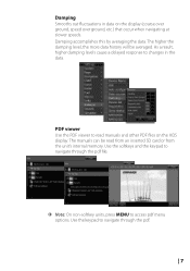
...: On non-softkey units, press Menu to navigate through the pdf. | 7 The higher the damping level, the more data history will be read manuals and other PDF files on the display (course over ground, speed over ground, etc.) that occur when navigating at slower speeds. Use the softkeys and... the keypad to access pdf menu options. The manuals can be averaged. Damping Smooths out fluctuations in the data. Damping accomplishes this by averaging the data. PDF viewer Use the PDF viewer to ...
...: On non-softkey units, press Menu to navigate through the pdf. | 7 The higher the damping level, the more data history will be read manuals and other PDF files on the display (course over ground, speed over ground, etc.) that occur when navigating at slower speeds. Use the softkeys and... the keypad to access pdf menu options. The manuals can be averaged. Damping Smooths out fluctuations in the data. Damping accomplishes this by averaging the data. PDF viewer Use the PDF viewer to ...
HDS Gen2 2.5 software release addendum - EN
Page 16
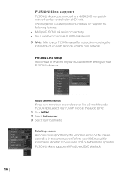
..., like a SonicHub and a FUSION radio, select your FUSION radio Selecting a source Audio sources supported by a HDS unit. Refer to your HDS manual for instructions covering the installation of a FUSION radio on your HDS unit before setting up your FUSION manual for information about IPOD, Sirius radio, USB or AM/FM radio operation. FUSION-Link support...
..., like a SonicHub and a FUSION radio, select your FUSION radio Selecting a source Audio sources supported by a HDS unit. Refer to your HDS manual for instructions covering the installation of a FUSION radio on your HDS unit before setting up your FUSION manual for information about IPOD, Sirius radio, USB or AM/FM radio operation. FUSION-Link support...
Operation Manual
Page 4
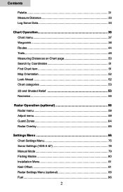
Contents Palette...31 Measure Distance 33 Log Sonar Data 33 Chart Operation 36 Chart menu 37 Waypoints 38 Routes...44 Trails...48 Measuring Distances on Chart page 50 Search by Coordinates 51 Find Chart item 51 Map Orientation 52 Look Ahead 52 Chart categories 53 2D and Shaded Relief 53 Navionics 55 Radar Operation (optional 58 Radar menu 59 Adjust menu 59 Guard Zones 64 Radar Overlay 65 Settings Menu 66 Chart Settings Menu 75 Sonar Settings (HDS-5 &7 78 Manual Mode 79 Fishing Modes 80 Installation Menu 81 Keel Offset 81 Radar Settings Menu (optional 85 Fuel...96 2
Contents Palette...31 Measure Distance 33 Log Sonar Data 33 Chart Operation 36 Chart menu 37 Waypoints 38 Routes...44 Trails...48 Measuring Distances on Chart page 50 Search by Coordinates 51 Find Chart item 51 Map Orientation 52 Look Ahead 52 Chart categories 53 2D and Shaded Relief 53 Navionics 55 Radar Operation (optional 58 Radar menu 59 Adjust menu 59 Guard Zones 64 Radar Overlay 65 Settings Menu 66 Chart Settings Menu 75 Sonar Settings (HDS-5 &7 78 Manual Mode 79 Fishing Modes 80 Installation Menu 81 Keel Offset 81 Radar Settings Menu (optional 85 Fuel...96 2
Operation Manual
Page 6
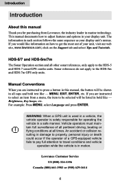
...HDS-5 and HDS-7 sonar/GPS combo units. An accident or collision resulting in damage to property, personal injury or death could occur if the operator of all pertinent driving, boating or flying conditions at all times. This manual documents how to adjust features and options in your display unit's menus. Lowrance...etc. click on how to press a button in this manual Thank you are instructed to select an item from Lowrance, the industry leader in marine technology. Menu, Exit, Enter, etc. Introduction Introduction About this manual, the button will be shown in all caps and bold...
...HDS-5 and HDS-7 sonar/GPS combo units. An accident or collision resulting in damage to property, personal injury or death could occur if the operator of all pertinent driving, boating or flying conditions at all times. This manual documents how to adjust features and options in your display unit's menus. Lowrance...etc. click on how to press a button in this manual Thank you are instructed to select an item from Lowrance, the industry leader in marine technology. Menu, Exit, Enter, etc. Introduction Introduction About this manual, the button will be shown in all caps and bold...

Operation Manual
Page 40
... the Chart page. A pop-up box will appear describing the POI. Move the cursor over a POI. You also can create a waypoint at any location by manually entering the position's latitude and longitude. 38 Chart Orientation Chart detail Look ahead Categories Imagery Chart Options Controls the way the Chart page moves in...
... the Chart page. A pop-up box will appear describing the POI. Move the cursor over a POI. You also can create a waypoint at any location by manually entering the position's latitude and longitude. 38 Chart Orientation Chart detail Look ahead Categories Imagery Chart Options Controls the way the Chart page moves in...

