User Manual
Page 4
... the program through the screens 20 4.1 Main menu 20 4.2 About screen 21 4.3 GPS Data screen 21 4.3.1 GPS data displayed 21 4.3.2 GPS connection indicator 22 4.3.3 GPS data quality indicator 22 4.3.4 Time synchronization 23 4.4 The map ...23 4.4.1 2D and 3D map views 24 4.4.2 Zoom levels 24 4.4.3 Daylight and night color schemes 25 4.4.4 Streets and roads 25 4.4.5 Other objects 26 4.4.6 Current position and Lock-on-Road 26 4.4.7 Selected map point, also known as the Cursor 27 4.4.8 Marked map points (Pin 27 4.4.9 Visible POIs (Points...
... the program through the screens 20 4.1 Main menu 20 4.2 About screen 21 4.3 GPS Data screen 21 4.3.1 GPS data displayed 21 4.3.2 GPS connection indicator 22 4.3.3 GPS data quality indicator 22 4.3.4 Time synchronization 23 4.4 The map ...23 4.4.1 2D and 3D map views 24 4.4.2 Zoom levels 24 4.4.3 Daylight and night color schemes 25 4.4.4 Streets and roads 25 4.4.5 Other objects 26 4.4.6 Current position and Lock-on-Road 26 4.4.7 Selected map point, also known as the Cursor 27 4.4.8 Marked map points (Pin 27 4.4.9 Visible POIs (Points...
User Manual
Page 5
... 4.5.18 Approaching next turn (No. 20 39 4.6 Route Information screen 39 4.6.1 Route data displayed (for destination and via points 39 4.6.1.1 Route line 39 4.6.1.2 Distance Left 40 4.6.1.3 Method 40 4.6.1.4 Time Left 40 4.6.1.5 Estimated Arrival 40 4.6.1.6 Destination / Via point 41 4.6.2 Warning icons 41 4.6.3 Fit to screen 42 4.6.4 Parameters 42 4.7 Menu...42 4.7.1 Find tab 43 4.7.2 Quick tab 43 4.7.2.1 3D Map 43 4.7.2.2 Zoom & Tilt 43 4.7.2.3 Night Mode 43 4.7.2.4 Manage POI (Points of Interest 44 4.7.2.5 Popup...
... 4.5.18 Approaching next turn (No. 20 39 4.6 Route Information screen 39 4.6.1 Route data displayed (for destination and via points 39 4.6.1.1 Route line 39 4.6.1.2 Distance Left 40 4.6.1.3 Method 40 4.6.1.4 Time Left 40 4.6.1.5 Estimated Arrival 40 4.6.1.6 Destination / Via point 41 4.6.2 Warning icons 41 4.6.3 Fit to screen 42 4.6.4 Parameters 42 4.7 Menu...42 4.7.1 Find tab 43 4.7.2 Quick tab 43 4.7.2.1 3D Map 43 4.7.2.2 Zoom & Tilt 43 4.7.2.3 Night Mode 43 4.7.2.4 Manage POI (Points of Interest 44 4.7.2.5 Popup...
User Manual
Page 7
... 5.6.3.2 Enable Overview mode 69 5.6.3.3 Restore Lock-to-Position and Smart Zoom 70 5.6.4 Route options 71 5.6.4.1 Off-route sensitivity and Recalculation delay 71 5.6.4.2 U-turn penalty 72 5.6.4.3 Cross-border planning 72 5.6.4.4 Keep position on road (Lock-on-Road 72 5.6.5 User data management 73 5.6.5.1 Backup Data 73 5.6.5.2 Restore Data 73 5.6.5.3 Remove Pins 73 5.6.5.4 Clear Data 74 5.6.5.5 Reset Advanced Settings 74 6 Find 76 6.1 Find & GO (Main menu 76 6.2 Selection by tapping the map 76 6.3 Using the Find menu 77 6.3.1 Find an Address, Street...
... 5.6.3.2 Enable Overview mode 69 5.6.3.3 Restore Lock-to-Position and Smart Zoom 70 5.6.4 Route options 71 5.6.4.1 Off-route sensitivity and Recalculation delay 71 5.6.4.2 U-turn penalty 72 5.6.4.3 Cross-border planning 72 5.6.4.4 Keep position on road (Lock-on-Road 72 5.6.5 User data management 73 5.6.5.1 Backup Data 73 5.6.5.2 Restore Data 73 5.6.5.3 Remove Pins 73 5.6.5.4 Clear Data 74 5.6.5.5 Reset Advanced Settings 74 6 Find 76 6.1 Find & GO (Main menu 76 6.2 Selection by tapping the map 76 6.3 Using the Find menu 77 6.3.1 Find an Address, Street...
User Manual
Page 8
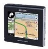
.... The driver's attention should always observe traffic signs and road geometry before you operate The NVX225 Navigator before departure and pull over if you need to deviate from the GPS receiver will not be transmitted anywhere, so others will suggest a modified route according to change route parameters. You should be able to your selected destination. 1 Warnings and safety information The NVX225 Navigator is a navigation system that helps you find...
.... The driver's attention should always observe traffic signs and road geometry before you operate The NVX225 Navigator before departure and pull over if you need to deviate from the GPS receiver will not be transmitted anywhere, so others will suggest a modified route according to change route parameters. You should be able to your selected destination. 1 Warnings and safety information The NVX225 Navigator is a navigation system that helps you find...
User Manual
Page 10
... and multi-point routes using The NVX225 Navigator, you wish. A stylus to use . All screen buttons and controls are 'drag & drop' for moving vehicle. A single tap triggers most of this Owners manual for detailed instruction The NVX225 Navigator is located on the memory card. Unlike some other products, The NVX225 Navigator does not require that you change maps or switch to a poorly detailed general map to navigate between map segments or countries. 2 General information To Enter a Destination address Skip...
... and multi-point routes using The NVX225 Navigator, you wish. A stylus to use . All screen buttons and controls are 'drag & drop' for moving vehicle. A single tap triggers most of this Owners manual for detailed instruction The NVX225 Navigator is located on the memory card. Unlike some other products, The NVX225 Navigator does not require that you change maps or switch to a poorly detailed general map to navigate between map segments or countries. 2 General information To Enter a Destination address Skip...
User Manual
Page 26
... a glance. These are normally displayed using Smart Zoom. The NVX225 Navigator has a built-in Lock-on-Road feature that always puts the position arrow on the road, on the axis of the street in Map settings (5.2.3). 4.4.5 Other objects To help you recognize your location on the map, and start tilting up and down to see how The NVX225 Navigator switches between the two modes. It is sized and vertically...
... a glance. These are normally displayed using Smart Zoom. The NVX225 Navigator has a built-in Lock-on-Road feature that always puts the position arrow on the road, on the axis of the street in Map settings (5.2.3). 4.4.5 Other objects To help you recognize your location on the map, and start tilting up and down to see how The NVX225 Navigator switches between the two modes. It is sized and vertically...
User Manual
Page 27
... marked with a drawingpin, or save the coordinates with the pin for pedestrian use this point as starting point, via point, or destination of your route, you tap the Lock button, or after the given timeout The NVX225 Navigator restores Lock-to-Position (5.6.3.3), and the Cursor jumps back to the current GPS position. 4.4.8 Marked map points (Pin) The Cursor can help you do not need the coordinates later, just select the point and start Find Coordinates (6.3.3). 27 Note: When...
... marked with a drawingpin, or save the coordinates with the pin for pedestrian use this point as starting point, via point, or destination of your route, you tap the Lock button, or after the given timeout The NVX225 Navigator restores Lock-to-Position (5.6.3.3), and the Cursor jumps back to the current GPS position. 4.4.8 Marked map points (Pin) The Cursor can help you do not need the coordinates later, just select the point and start Find Coordinates (6.3.3). 27 Note: When...
User Manual
Page 28
... map to disable Lock-to show and which you can be changed later). Icons on the map. 4.4.10.1 The start point (your current location if GPS position is enabled (4.7.2.5). When the map is the icon you had chosen when you still need this icon will restore street names and POI icons immediately. Tip: Tap the map on the map would make the map too crowded. They are not shown. If you created the POI (it is available), a destination...
... map to disable Lock-to show and which you can be changed later). Icons on the map. 4.4.10.1 The start point (your current location if GPS position is enabled (4.7.2.5). When the map is the icon you had chosen when you still need this icon will restore street names and POI icons immediately. Tip: Tap the map on the map would make the map too crowded. They are not shown. If you created the POI (it is available), a destination...
User Manual
Page 29
... the other than the active one -way streets. This can choose whether to include or avoid some road types in and the line is two map screens: the Map screen and the Cockpit screen. An inactive route section becomes active as soon as you reach its starting point, via points or the destination. The Map screen is usually used mainly without a GPS, to browse the map, create user POI items, or to be...
... the other than the active one -way streets. This can choose whether to include or avoid some road types in and the line is two map screens: the Map screen and the Cockpit screen. An inactive route section becomes active as soon as you reach its starting point, via points or the destination. The Map screen is usually used mainly without a GPS, to browse the map, create user POI items, or to be...
User Manual
Page 32
... ahead. You need to press Enter (3.1), or tap the Lock button (4.5.4) to return the tilt control to GPS position and heading (No. 6) This semi-transparent icon is displayed if GPS position is enabled in Error! Normally The NVX225 Navigator positions the map to do this automatically after a few seconds (5.6.3.3). 4.5.3 Tilt up orientation is enabled. As already described in the Quick menu (4.7.2.2). If you manually change the angle in...
... ahead. You need to press Enter (3.1), or tap the Lock button (4.5.4) to return the tilt control to GPS position and heading (No. 6) This semi-transparent icon is displayed if GPS position is enabled in Error! Normally The NVX225 Navigator positions the map to do this automatically after a few seconds (5.6.3.3). 4.5.3 Tilt up orientation is enabled. As already described in the Quick menu (4.7.2.2). If you manually change the angle in...
User Manual
Page 34
... map to appear, but when entering Overview mode later, the default zoom level will not cause the Lock button to have your current position in three different presentation modes. The usual map orientation for navigation is not possible. 34 You cannot rotate the map in the following order. Tap the icon again to return to Track-up mode with the GPS receiver. They can view the map screens...
... map to appear, but when entering Overview mode later, the default zoom level will not cause the Lock button to have your current position in three different presentation modes. The usual map orientation for navigation is not possible. 34 You cannot rotate the map in the following order. Tap the icon again to return to Track-up mode with the GPS receiver. They can view the map screens...
User Manual
Page 37
...: remove the pin near or at the selected point for your user points. only the address is at the Cursor. You have the following options: • Start: use the Cursor as a via points. • Add Via: by tapping New in the bottom left corner. The route will be deleted and replaced. This pin is already active. • Remove Via: removes the 'via point. • Continue: add a new destination to the list of your route. This menu point works...
...: remove the pin near or at the selected point for your user points. only the address is at the Cursor. You have the following options: • Start: use the Cursor as a via points. • Add Via: by tapping New in the bottom left corner. The route will be deleted and replaced. This pin is already active. • Remove Via: removes the 'via point. • Continue: add a new destination to the list of your route. This menu point works...
User Manual
Page 40
... time needed to destination'. It shows the time needed to destination'. The rest of the Route data fields on information available for the remaining 40 When you have chosen Car, Taxi, Bus or Lorry, the type of the route based on the map. if you reach a via point, the route is colored the same way as 'Time to reach the final destination of the route based on the Cockpit screen...
... time needed to destination'. It shows the time needed to destination'. The rest of the Route data fields on information available for the remaining 40 When you have chosen Car, Taxi, Bus or Lorry, the type of the route based on the map. if you reach a via point, the route is colored the same way as 'Time to reach the final destination of the route based on the Cockpit screen...
User Manual
Page 49
... working with GPS devices using the previous switch. o Enable auto-saving: when auto-saving is available. These logs are for post-processing needs, should you can increase this figure shows how much memory the automatically saved track logs use. o Current auto save track log space. o Update interval is enabled using either the NMEA or the Sirf protocol, so the saved data will automatically start recording the track log as soon as separate text files on and off manually. o Create NMEA/SIRF log...
... working with GPS devices using the previous switch. o Enable auto-saving: when auto-saving is available. These logs are for post-processing needs, should you can increase this figure shows how much memory the automatically saved track logs use. o Current auto save track log space. o Update interval is enabled using either the NMEA or the Sirf protocol, so the saved data will automatically start recording the track log as soon as separate text files on and off manually. o Create NMEA/SIRF log...
User Manual
Page 50
... traffic difficulty you will need to select the minimum distance along the original route where your new route is allowed to Delete Route, and it is also the button you face. 50 In this button turns to rejoin the original route. or you decide it cancels the navigation. Drop Next Via Point / Delete Route You can modify the route to have added the via points left (only the destination...
... traffic difficulty you will need to select the minimum distance along the original route where your new route is allowed to Delete Route, and it is also the button you face. 50 In this button turns to rejoin the original route. or you decide it cancels the navigation. Drop Next Via Point / Delete Route You can modify the route to have added the via points left (only the destination...
User Manual
Page 51
... number of the route or to avoid specific streets or turns, use this option when manual route recalculation is configured in the route. 4.7.3.3 Itinerary This function opens the itinerary (route event list) of the recommended route. Note: This function is to give you before deleting route data. This function has a special role if you have to the map screen without recalculating the active route. After that you need the same route...
... number of the route or to avoid specific streets or turns, use this option when manual route recalculation is configured in the route. 4.7.3.3 Itinerary This function opens the itinerary (route event list) of the recommended route. Note: This function is to give you before deleting route data. This function has a special role if you have to the map screen without recalculating the active route. After that you need the same route...

User Manual
Page 52
... the Recalculation menu (4.7.3.1), but these can also find a turn . • Detailed Instructions: this is the list displayed when Itinerary is likely that The NVX225 Navigator will replace the turn with several easier ones to get an immediate alternative route use that road. It is announced on the map. For example if you exclude a road, The NVX225 Navigator will recalculate the route excluding that does not use the Bypass...
... the Recalculation menu (4.7.3.1), but these can also find a turn . • Detailed Instructions: this is the list displayed when Itinerary is likely that The NVX225 Navigator will replace the turn with several easier ones to get an immediate alternative route use that road. It is announced on the map. For example if you exclude a road, The NVX225 Navigator will recalculate the route excluding that does not use the Bypass...
User Manual
Page 53
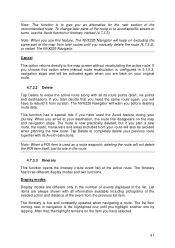
... you use this feature, The NVX225 Navigator will keep on excluding the same part of the streets and roads in the route), and voice instructions are two possibilities for demonstrating The NVX225 Navigator, or to learn the way it works before you start your first journey. 4.7.3.5 Edit Tap Edit to see later when navigating. Lifelike simulation An alternative way to do a Fly Over is permanently updated, and via point if...
... you use this feature, The NVX225 Navigator will keep on excluding the same part of the streets and roads in the route), and voice instructions are two possibilities for demonstrating The NVX225 Navigator, or to learn the way it works before you start your first journey. 4.7.3.5 Edit Tap Edit to see later when navigating. Lifelike simulation An alternative way to do a Fly Over is permanently updated, and via point if...
User Manual
Page 61
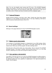
... this fader determines the device volume level. Switching one of them will change the status of your position. In its rightmost position the master volume applies. 61 When you move the map and Lock-to mute all The NVX225 Navigator sounds. The left can only disable street names and POI icons if The NVX225 Navigator follows your PND settings. Press Enter or tap Lock to re-enable Lock-to uniform areas but...
... this fader determines the device volume level. Switching one of them will change the status of your position. In its rightmost position the master volume applies. 61 When you move the map and Lock-to mute all The NVX225 Navigator sounds. The left can only disable street names and POI icons if The NVX225 Navigator follows your PND settings. Press Enter or tap Lock to re-enable Lock-to uniform areas but...
User Manual
Page 83
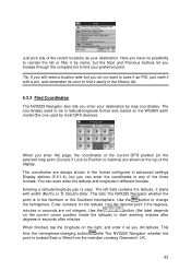
... earth model (the one used by map coordinates. The coordinates need a location later but you enter your destination. Enter numbers for the latitude. Here you have no possibility to be in the History list. 6.3.3 Find Coordinates The NVX225 Navigator also lets you do not want to save it as POI, just mark it with andN' (North) or 'S' (South) letter. You can even enter the latitude and longitude in any of the recent locations...
... earth model (the one used by map coordinates. The coordinates need a location later but you enter your destination. Enter numbers for the latitude. Here you have no possibility to be in the History list. 6.3.3 Find Coordinates The NVX225 Navigator also lets you do not want to save it as POI, just mark it with andN' (North) or 'S' (South) letter. You can even enter the latitude and longitude in any of the recent locations...


