Owner's Manual
Page 12
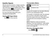
... When at least one of the roads on , it begins acquiring satellite signals. Viewing GPS Signal Status Hold for three seconds. Pedestrian mode calculates time of the sky to www.garmin.com/aboutGPS. Transportation Modes Automobile mode Pedestrian mode Routing and navigation are calculated differently based on your device, pedestrian routes may need a clear...
... When at least one of the roads on , it begins acquiring satellite signals. Viewing GPS Signal Status Hold for three seconds. Pedestrian mode calculates time of the sky to www.garmin.com/aboutGPS. Transportation Modes Automobile mode Pedestrian mode Routing and navigation are calculated differently based on your device, pedestrian routes may need a clear...
Owner's Manual
Page 21
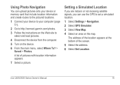
Using Photo Navigation You can use the GPS to select and load pictures. 4 Disconnect the device from the computer. 5 Turn on the map. The address of the location appears at the bottom of ... satellite signals, you can upload pictures onto your device or memory card that include location information and create routes to the pictured locations. 1 Connect your device to your computer (page 51). 2 Go to http://connect.garmin.com/photos. 3 Follow the instructions on the Web site to set a simulated location. 1 Select Settings > Navigation. 2 Select GPS...
Using Photo Navigation You can use the GPS to select and load pictures. 4 Disconnect the device from the computer. 5 Turn on the map. The address of the location appears at the bottom of ... satellite signals, you can upload pictures onto your device or memory card that include location information and create routes to the pictured locations. 1 Connect your device to your computer (page 51). 2 Go to http://connect.garmin.com/photos. 3 Follow the instructions on the Web site to set a simulated location. 1 Select Settings > Navigation. 2 Select GPS...


