
Important Safety and Product Information
Page 1
... aware of direction, distance, location, or topography. Navigation Warnings If your Garmin® device uses or accepts map data, follow the route suggestions if they suggest an illegal course or would put you from -4° to observe all road and driving conditions, abide by all driving conditions. Minimize the amount of time spent viewing the device screen while driving. • Do not input destinations, change settings, or access...
... aware of direction, distance, location, or topography. Navigation Warnings If your Garmin® device uses or accepts map data, follow the route suggestions if they suggest an illegal course or would put you from -4° to observe all road and driving conditions, abide by all driving conditions. Minimize the amount of time spent viewing the device screen while driving. • Do not input destinations, change settings, or access...

Important Safety and Product Information
Page 2
... power mode and when used by an authorized Garmin service center. Product Environmental Programs Information about the Garmin product recycling program and WEEE, RoHS, REACH, and other transmitter or antenna. The full text of the declaration of conformity is for a Class B digital device, pursuant to any Global Navigation Satellite System (GNSS), such as a result of any interference received, including interference that uses an internal antenna to use safe...
... power mode and when used by an authorized Garmin service center. Product Environmental Programs Information about the Garmin product recycling program and WEEE, RoHS, REACH, and other transmitter or antenna. The full text of the declaration of conformity is for a Class B digital device, pursuant to any Global Navigation Satellite System (GNSS), such as a result of any interference received, including interference that uses an internal antenna to use safe...

Important Safety and Product Information
Page 3
... THE LAWS OF YOUR STATE, COUNTRY OR PROVINCE. Garmin makes no charge to the accuracy or completeness of GNSS signals. In some inaccurate or incomplete data. Garmin navigation products are not labeled as to the customer for parts or labor, provided that meets Garmin's quality standards, or (iii) exchange the device for one year from the date of direction, distance, location or topography. SUCH...
... THE LAWS OF YOUR STATE, COUNTRY OR PROVINCE. Garmin makes no charge to the accuracy or completeness of GNSS signals. In some inaccurate or incomplete data. Garmin navigation products are not labeled as to the customer for parts or labor, provided that meets Garmin's quality standards, or (iii) exchange the device for one year from the date of direction, distance, location or topography. SUCH...
Important Safety and Product Information
Page 4
... country due to the Garmin service center in the United Kingdom, the United States, Canada, or Taiwan for service Australian Purchases: Our goods come with guarantees that country. In some cases, Garmin and its sole discretion and subject to applicable laws, repair your product with comparable parts or replace your product with a comparable Garmin product (new or a Garmin Recertified replacement), or require you to...
... country due to the Garmin service center in the United Kingdom, the United States, Canada, or Taiwan for service Australian Purchases: Our goods come with guarantees that country. In some cases, Garmin and its sole discretion and subject to applicable laws, repair your product with comparable parts or replace your product with a comparable Garmin product (new or a Garmin Recertified replacement), or require you to...

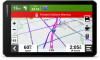
Owners Manual
Page 3
... Started 1 dēzlCam Device Overview 1 Installing the Dash Camera Memory Card 2 Mounting Considerations 2 Mounting and Powering the dēzlCam Device in Your Vehicle 3 Turning the Device On or Off 6 Acquiring GPS Signals 6 Status Bar Icons 7 Using the On-Screen Buttons 7 Adjusting the Volume 7 Using the Audio Mixer 8 Enabling or Disabling Sounds and Audio Sources 8 Adjusting the Screen Brightness 8 Vehicle Profiles 8 Adding a Vehicle Profile 8 Adding an Environmental Zone Vehicle Profile 9 Car Profile 9 Switching the Vehicle Profile 9 Changing Your Trailer Information...
... Started 1 dēzlCam Device Overview 1 Installing the Dash Camera Memory Card 2 Mounting Considerations 2 Mounting and Powering the dēzlCam Device in Your Vehicle 3 Turning the Device On or Off 6 Acquiring GPS Signals 6 Status Bar Icons 7 Using the On-Screen Buttons 7 Adjusting the Volume 7 Using the Audio Mixer 8 Enabling or Disabling Sounds and Audio Sources 8 Adjusting the Screen Brightness 8 Vehicle Profiles 8 Adding a Vehicle Profile 8 Adding an Environmental Zone Vehicle Profile 9 Car Profile 9 Switching the Vehicle Profile 9 Changing Your Trailer Information...

Owners Manual
Page 4
... 37 Bluetooth Feature Status Icons 37 Smart Notifications 38 Receiving Notifications 38 Viewing the List of Notifications...... 39 Going to an Address or Location Using the dēzl App 39 Hands-Free Calling 39 Placing a Call 39 Receiving a Call 40 Using the Call History 40 Using In-Call Options 40 Saving a Home Phone Number........ 40 Deleting a Paired Phone 41 Traffic 41 Receiving Traffic Data Using Your Smartphone 41 Enabling Traffic 41 Viewing Traffic on the Map 41 Searching for Traffic Incidents...
... 37 Bluetooth Feature Status Icons 37 Smart Notifications 38 Receiving Notifications 38 Viewing the List of Notifications...... 39 Going to an Address or Location Using the dēzl App 39 Hands-Free Calling 39 Placing a Call 39 Receiving a Call 40 Using the Call History 40 Using In-Call Options 40 Saving a Home Phone Number........ 40 Deleting a Paired Phone 41 Traffic 41 Receiving Traffic Data Using Your Smartphone 41 Enabling Traffic 41 Viewing Traffic on the Map 41 Searching for Traffic Incidents...

Owners Manual
Page 5
...; App 53 Activating a Power Switch 53 Turning Off All Switches 53 Customizing a Button 54 Assigning a Switch to a Control Input 54 Adding a Custom Layout 54 Routines 55 Voice Command 56 Tips for Speaking to the Device........... 56 Launching Garmin Voice-Activated Navigation 57 Controlling the Camera Using Voice Commands 57 Checking Your Arrival Time 57 Placing a Phone Call Using Your Voice 57 Changing Device Settings Using Your Voice 57 Settings 57 Map and Vehicle Settings 57 Enabling Maps 58 Navigation Settings 58 Calculation Mode Settings 58 Setting a Simulated Location...
...; App 53 Activating a Power Switch 53 Turning Off All Switches 53 Customizing a Button 54 Assigning a Switch to a Control Input 54 Adding a Custom Layout 54 Routines 55 Voice Command 56 Tips for Speaking to the Device........... 56 Launching Garmin Voice-Activated Navigation 57 Controlling the Camera Using Voice Commands 57 Checking Your Arrival Time 57 Placing a Phone Call Using Your Voice 57 Changing Device Settings Using Your Voice 57 Settings 57 Map and Vehicle Settings 57 Enabling Maps 58 Navigation Settings 58 Calculation Mode Settings 58 Setting a Simulated Location...

Owners Manual
Page 6
Driver Assistance Settings 59 Proximity Alerts Settings 59 Dash Cam Settings 60 Backup Camera Settings 60 Display Settings 60 Traffic Settings 60 Units and Time Settings 60 Setting the Time 61 Language and Keyboard Settings........ 61 Device and Privacy Settings 61 Resetting Data and Settings 61 Device Information 61 Viewing E-label Regulatory and Compliance Information 61 Specifications 62 Charging the Device 62 Device Maintenance 62 Garmin Support Center 62 Map and Software Updates 62 Connecting to a Wi‑Fi Network......... 62 Updating Maps and Software Using a Wi‑...
Driver Assistance Settings 59 Proximity Alerts Settings 59 Dash Cam Settings 60 Backup Camera Settings 60 Display Settings 60 Traffic Settings 60 Units and Time Settings 60 Setting the Time 61 Language and Keyboard Settings........ 61 Device and Privacy Settings 61 Resetting Data and Settings 61 Device Information 61 Viewing E-label Regulatory and Compliance Information 61 Specifications 62 Charging the Device 62 Device Maintenance 62 Garmin Support Center 62 Map and Software Updates 62 Connecting to a Wi‑Fi Network......... 62 Updating Maps and Software Using a Wi‑...

Owners Manual
Page 13
... to adjust the volume. • Select to mute the device. • Select a check box to view the current ELD information. GPS signal status. Select to open the dash cam controls. Select to change settings or view additional information. Status Bar Icons The status bar is connected to view the weather forecast (Viewing the Weather Forecast, page 46). Garmin eLog™ status. Current time. Dash cam recording status. Using the On-Screen Buttons On-screen buttons allow you to navigate the...
... to adjust the volume. • Select to mute the device. • Select a check box to view the current ELD information. GPS signal status. Select to open the dash cam controls. Select to change settings or view additional information. Status Bar Icons The status bar is connected to view the weather forecast (Viewing the Weather Forecast, page 46). Garmin eLog™ status. Current time. Dash cam recording status. Using the On-Screen Buttons On-screen buttons allow you to navigate the...

Owners Manual
Page 19
... road. Wrong way on a one-way street: The device plays a message and displays a full-screen warning if you may be receiving traffic information to use safe driving judgment at a higher speed. Speed limit exceeded: The device displays a red border on a one -way street or correct your direction of travel the wrong way on the speed limit icon when you can enable or disable the audible tone for some types of driver alerts. 1 Select > Driver...
... road. Wrong way on a one-way street: The device plays a message and displays a full-screen warning if you may be receiving traffic information to use safe driving judgment at a higher speed. Speed limit exceeded: The device displays a red border on a one -way street or correct your direction of travel the wrong way on the speed limit icon when you can enable or disable the audible tone for some types of driver alerts. 1 Select > Driver...

Owners Manual
Page 28
... give you need to your current location, your current location. From the map, select the vehicle. Getting Directions to Your Current Location If you a list of locations for the selected service appears, with the nearest locations at the top. 3 Select a location. 4 Select an option: • To navigate to the location, select Go! • To view the phone number and other location details, select . Finding Parking Near Your Current Location 1 Select Where To? > Categories > Parking. 2 Select a parking location. 3 Select Go!. Viewing Recently Found Locations Your device stores a history...
... give you need to your current location, your current location. From the map, select the vehicle. Getting Directions to Your Current Location If you a list of locations for the selected service appears, with the nearest locations at the top. 3 Select a location. 4 Select an option: • To navigate to the location, select Go! • To view the phone number and other location details, select . Finding Parking Near Your Current Location 1 Select Where To? > Categories > Parking. 2 Select a parking location. 3 Select Go!. Viewing Recently Found Locations Your device stores a history...

Owners Manual
Page 30
... are specific roads you need to use or avoid, you to enter your home location. 1 Select Where To? > Go Home. 2 If necessary, enter your home location. Navigating to Your Destination Routes A route is a path from the map. 1 Select View Map. 2 Drag and zoom the map to display the area to search. 3 Select an option: • Select a location marker. • Select a point, such as a street, intersection, or address location. 4 Select Go!. Starting a Route 1 Select Where To?, and search for several seconds. Editing Your Home Location 1 Select Where To? > > Set Home Location. 2 Enter your...
... are specific roads you need to use or avoid, you to enter your home location. 1 Select Where To? > Go Home. 2 If necessary, enter your home location. Navigating to Your Destination Routes A route is a path from the map. 1 Select View Map. 2 Drag and zoom the map to display the area to search. 3 Select an option: • Select a location marker. • Select a point, such as a street, intersection, or address location. 4 Select Go!. Starting a Route 1 Select Where To?, and search for several seconds. Editing Your Home Location 1 Select Where To? > > Set Home Location. 2 Enter your...

Owners Manual
Page 34
... using the car vehicle profile. NOTE: When you must start a route (Starting a Route, page 24). TIP: You can add a fuel station as the next destination in your route. 1 From the map, select > Where To?. 2 Search for a specific distance, select Detour by Road. 28 Navigating to the route, select additional locations on the map. • To remove a shaping point, select the shaping point and select . The device enters route shaping mode and recalculates the route to zoom in order. Changing Your Active Route Adding a Location...
... using the car vehicle profile. NOTE: When you must start a route (Starting a Route, page 24). TIP: You can add a fuel station as the next destination in your route. 1 From the map, select > Where To?. 2 Search for a specific distance, select Detour by Road. 28 Navigating to the route, select additional locations on the map. • To remove a shaping point, select the shaping point and select . The device enters route shaping mode and recalculates the route to zoom in order. Changing Your Active Route Adding a Location...
Owners Manual
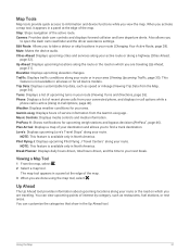
Page 37
... using the map tool, select . Cities Ahead: Displays upcoming cities and services along your active route or along your route (Viewing Turns and Directions, page 26). This feature is available only in the Up Ahead tool. Turns: Displays a list of upcoming turns in a panel at the edge of the map. Viewing a Map Tool 1 From the map, select . 2 Select a map tool. The map tool appears in your route. Also allows you are traveling. Mute: Mutes the device audio. Elevation: Displays upcoming elevation changes. Trip Data: Displays...
... using the map tool, select . Cities Ahead: Displays upcoming cities and services along your active route or along your route (Viewing Turns and Directions, page 26). This feature is available only in the Up Ahead tool. Turns: Displays a list of upcoming turns in a panel at the edge of the map. Viewing a Map Tool 1 From the map, select . 2 Select a map tool. The map tool appears in your route. Also allows you are traveling. Mute: Mutes the device audio. Elevation: Displays upcoming elevation changes. Trip Data: Displays...

Owners Manual
Page 42
... navigation device. Send locations to device: Allows you to use the dēzl app to customize which types of each other features. 1 Select > Wireless Networks. 2 Select an option: • To disable all compatible Bluetooth features are turned on your dēzlCam device. 1 On your phone, open the dēzl app. 4 Follow the on-screen instructions to sign in to a Garmin account and complete the pairing and setup process. After the devices are paired...
... navigation device. Send locations to device: Allows you to use the dēzl app to customize which types of each other features. 1 Select > Wireless Networks. 2 Select an option: • To disable all compatible Bluetooth features are turned on your dēzlCam device. 1 On your phone, open the dēzl app. 4 Follow the on-screen instructions to sign in to a Garmin account and complete the pairing and setup process. After the devices are paired...
Owners Manual
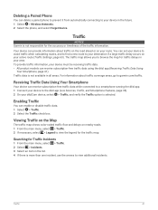
Page 47
... product models can enable or disable traffic data. 1 Select > Traffic. 2 Select the Traffic check box. The traffic map allows you to the dēzl app (Live Services, Traffic, and Smartphone Features, page 36). 2 On your active route (Traffic Settings, page 60). Receiving Traffic Data Using Your Smartphone Your device can receive subscription-free traffic data while connected to a smartphone running the dēzl app. 1 Connect your device in all areas. Traffic 41 Your device can provide information about traffic coverage areas, go to garmin.com/traffic. Traffic data...
... product models can enable or disable traffic data. 1 Select > Traffic. 2 Select the Traffic check box. The traffic map allows you to the dēzl app (Live Services, Traffic, and Smartphone Features, page 36). 2 On your active route (Traffic Settings, page 60). Receiving Traffic Data Using Your Smartphone Your device can receive subscription-free traffic data while connected to a smartphone running the dēzl app. 1 Connect your device in all areas. Traffic 41 Your device can provide information about traffic coverage areas, go to garmin.com/traffic. Traffic data...

Owners Manual
Page 63
... say a phrase to search for locations and addresses, start routes with turn-by-turn directions, place hands-free phone calls, and more. • Say OK, Garmin, and make a spoken request. Settings Map and Vehicle Settings Select > Map Display. Map Theme: Changes the color of your position on the map. When disabled, you to use plain language spoken requests to check your estimated time of your destination. Checking Your Arrival Time While a route is active, you can use of the map data. Say OK, Garmin, call, and say...
... say a phrase to search for locations and addresses, start routes with turn-by-turn directions, place hands-free phone calls, and more. • Say OK, Garmin, and make a spoken request. Settings Map and Vehicle Settings Select > Map Display. Map Theme: Changes the color of your position on the map. When disabled, you to use plain language spoken requests to check your estimated time of your destination. Checking Your Arrival Time While a route is active, you can use of the map data. Say OK, Garmin, call, and say...

Owners Manual
Page 67
Text Language: Sets all settings to the factory default values, select Delete Data and Reset Settings. NOTE: Changing the text language does not change the language of the menu. 2 Select Device > Regulatory. About: Displays the software version number, the unit ID number, and information on -screen text to improve the device. Regulatory: Displays regulatory markings and information. Device Data Reporting: Shares anonymous data to the selected language. It does not delete saved locations or installed maps. • To reset all settings to clear your user data and resetting all on...
Text Language: Sets all settings to the factory default values, select Delete Data and Reset Settings. NOTE: Changing the text language does not change the language of the menu. 2 Select Device > Regulatory. About: Displays the software version number, the unit ID number, and information on -screen text to improve the device. Regulatory: Displays regulatory markings and information. Device Data Reporting: Shares anonymous data to the selected language. It does not delete saved locations or installed maps. • To reset all settings to clear your user data and resetting all on...

Owners Manual
Page 74
...; Transfer important recordings to a computer or smartphone, and format the memory card. • If the device displays a memory card error alert, first try formatting the memory card and then, if necessary, replace the memory card. • Turn off the device when your device to the latest software (Map and Software Updates, page 62). My device is not acquiring satellite signals • Verify the GPS simulator is time to format or replace your vehicle is not in the specifications. • In the vehicle fuse box...
...; Transfer important recordings to a computer or smartphone, and format the memory card. • If the device displays a memory card error alert, first try formatting the memory card and then, if necessary, replace the memory card. • Turn off the device when your device to the latest software (Map and Software Updates, page 62). My device is not acquiring satellite signals • Verify the GPS simulator is time to format or replace your vehicle is not in the specifications. • In the vehicle fuse box...
Owners Manual
Page 75
... device product page at garmin.com or from your device. Viewing GPS Signal Status Hold for three seconds. Memory cards must unpair your vehicle dealer or manufacturer for more information. • Complete the pairing process again. Appendix Installing a Memory Card for Maps and Data You can find your vehicle's emission standards in direct sunlight. Memory cards greater than 32 GB must be formatted using the device. 1 Locate the map and data memory card slot on -screen instructions. If you are available at garmin...
... device product page at garmin.com or from your device. Viewing GPS Signal Status Hold for three seconds. Memory cards must unpair your vehicle dealer or manufacturer for more information. • Complete the pairing process again. Appendix Installing a Memory Card for Maps and Data You can find your vehicle's emission standards in direct sunlight. Memory cards greater than 32 GB must be formatted using the device. 1 Locate the map and data memory card slot on -screen instructions. If you are available at garmin...

