GXM 30 for Auto Products Owner's Manual
Page 9
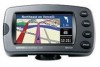
Touch Forecast to your Garmin unit. NOTE: You might have a subscription to XM NavTraffic™ to get current weather conditions: 1. Touch any city for Automotive Owner's Manual 3. From the Menu page, touch Tools > Weather > Current Conditions. USING XM WEATHER Getting Current Conditions To get traffic and weather functions on ... the name of XM Weather sources, touch Near > Near Other City. 2. USING XM WEATHER NOTE: You must have to wait up to 12 minutes to receive the broadcast of the weather information. To select a different city: 1.
Touch Forecast to your Garmin unit. NOTE: You might have a subscription to XM NavTraffic™ to get current weather conditions: 1. Touch any city for Automotive Owner's Manual 3. From the Menu page, touch Tools > Weather > Current Conditions. USING XM WEATHER Getting Current Conditions To get traffic and weather functions on ... the name of XM Weather sources, touch Near > Near Other City. 2. USING XM WEATHER NOTE: You must have to wait up to 12 minutes to receive the broadcast of the weather information. To select a different city: 1.
GXM 30 for Auto Products Owner's Manual
Page 15
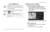
...fic functions on the map; For coverage cities for Automotive Owner's Manual USING TRAFFIC INFORMATION Viewing Traffic From the Menu page, touch Tools > Traffic Info. Medium severity; so, if necessary, you can receive and use traffic information. Traffic Information Symbol... of the traffic incident: Low severity; traffic is heavily congested or stopped. 9 Using your GXM 30, your Garmin unit can change your Garmin unit. Select an item in the Traffic Information list to avoid a traffic incident. traffic is a bit...
...fic functions on the map; For coverage cities for Automotive Owner's Manual USING TRAFFIC INFORMATION Viewing Traffic From the Menu page, touch Tools > Traffic Info. Medium severity; so, if necessary, you can receive and use traffic information. Traffic Information Symbol... of the traffic incident: Low severity; traffic is heavily congested or stopped. 9 Using your GXM 30, your Garmin unit can change your Garmin unit. Select an item in the Traffic Information list to avoid a traffic incident. traffic is a bit...
GXM 30 for Auto Products Owner's Manual
Page 18
... following conditions: (1) This device may not cause harmful interference, and (2) this device must accept any interference received, including interference that interference will not occur in accordance with Part 15 of the FCC interference limits for Automotive Owner's Manual This equipment generates, uses, and can radiate radio frequency energy and may cause undesired...
... following conditions: (1) This device may not cause harmful interference, and (2) this device must accept any interference received, including interference that interference will not occur in accordance with Part 15 of the FCC interference limits for Automotive Owner's Manual This equipment generates, uses, and can radiate radio frequency energy and may cause undesired...
GXM 30 for Auto Products Owner's Manual
Page 19
..., and void your warranty and your authority to operate this device under the United States of Garmin and is connected. • Consult the dealer or an experienced radio/TV technician for Automotive Owner's Manual 13 PLEASE READ THIS AGREEMENT CAREFULLY. GXM 30 XM Smart Antenna for help.... in source code form remains a valuable trade secret of the following measures: • Reorient or relocate the receiving antenna. • Increase the separation between the equipment and the receiver. • Connect the equipment into an outlet on , the user is encouraged to try to correct the ...
..., and void your warranty and your authority to operate this device under the United States of Garmin and is connected. • Consult the dealer or an experienced radio/TV technician for Automotive Owner's Manual 13 PLEASE READ THIS AGREEMENT CAREFULLY. GXM 30 XM Smart Antenna for help.... in source code form remains a valuable trade secret of the following measures: • Reorient or relocate the receiving antenna. • Increase the separation between the equipment and the receiver. • Connect the equipment into an outlet on , the user is encouraged to try to correct the ...

GXM 30 for Auto Products Owner's Manual
Page 23
... by NGA as to stop using DAFIF™, a product of the National Geospatial-Intelligence Agency. TOTAL LIABILITY TO YOU AND ANY OTHER PERSONS RECEIVING OUR SERVICES, REGARDLESS OF THE CAUSE, WILL IN NO EVENT EXCEED THE AMOUNTS THAT YOU HAVE PAID TO US FOR THE SERVICE THAT YOU...arising by statute or otherwise in law or from a course of dealing or usage in trade, is ," and no civil action may be liable for Automotive Owner's Manual 17 Under 10 U.S.C. 456, no warranty, express or implied, including, but not limited to hold harmless the United States National Geospatial-Intelligence...
... by NGA as to stop using DAFIF™, a product of the National Geospatial-Intelligence Agency. TOTAL LIABILITY TO YOU AND ANY OTHER PERSONS RECEIVING OUR SERVICES, REGARDLESS OF THE CAUSE, WILL IN NO EVENT EXCEED THE AMOUNTS THAT YOU HAVE PAID TO US FOR THE SERVICE THAT YOU...arising by statute or otherwise in law or from a course of dealing or usage in trade, is ," and no civil action may be liable for Automotive Owner's Manual 17 Under 10 U.S.C. 456, no warranty, express or implied, including, but not limited to hold harmless the United States National Geospatial-Intelligence...

Owner's Manual
Page 5
... 32 Using the Hands-Free Phone Features 33 Traffic Information 36 Connecting the Receiver or Antenna 36 Viewing Traffic Incidents 36 Avoiding Traffic 36 Adding a Traffic Subscription 37 Customizing the StreetPilot 2820 38 Adjusting the Volume 38 Customizing the General Settings 38 Changing the Map ... Technology Settings 45 Viewing Unit Information (About 45 Restoring the Settings 45 Appendix 46 Register Your StreetPilot 2820 46 Installing the 2820 in Your Vehicle 46 Using a Remote GPS Antenna 47 Changing the Fuse 47 Using the Remote Control 48 Custom POIs (Points of Interest ...
... 32 Using the Hands-Free Phone Features 33 Traffic Information 36 Connecting the Receiver or Antenna 36 Viewing Traffic Incidents 36 Avoiding Traffic 36 Adding a Traffic Subscription 37 Customizing the StreetPilot 2820 38 Adjusting the Volume 38 Customizing the General Settings 38 Changing the Map ... Technology Settings 45 Viewing Unit Information (About 45 Restoring the Settings 45 Appendix 46 Register Your StreetPilot 2820 46 Installing the 2820 in Your Vehicle 46 Using a Remote GPS Antenna 47 Changing the Fuse 47 Using the Remote Control 48 Custom POIs (Points of Interest ...

Owner's Manual
Page 23
...signal strength bars The sky view shows the satellites you are receiving. For more information about the GPS Settings. Viewing the Map and Using the Tools StreetPilot 2820 Owner's Manual 15 Or, from the Menu page, touch Tools > GPS Info. The satellite signal strength bars indicate the strength of... the screen to view the GPS Info page. A solid bar indicates your StreetPilot 2820 has a strong fix on that GPS satellite, and the GPS satellite is ready for information about GPS, see www.garmin.com /aboutGPS/. GPS Info Page From the map or Menu page, touch the...
...signal strength bars The sky view shows the satellites you are receiving. For more information about the GPS Settings. Viewing the Map and Using the Tools StreetPilot 2820 Owner's Manual 15 Or, from the Menu page, touch Tools > GPS Info. The satellite signal strength bars indicate the strength of... the screen to view the GPS Info page. A solid bar indicates your StreetPilot 2820 has a strong fix on that GPS satellite, and the GPS satellite is ready for information about GPS, see www.garmin.com /aboutGPS/. GPS Info Page From the map or Menu page, touch the...

Owner's Manual
Page 27
...Menu page, touch Tools > My Data > Routes > Save Active Route. Touch the route you have entered for the next five miles. Your StreetPilot 2820 recalculates your current route, open the Menu page and touch Detour. 1/2 mile, 2 miles, or 5 miles-select the distance of roads. Detour...Receiver, you need to avoid that the street is closed for the next three miles, touch 5 miles in the list of the detour. Deleting All Saved Routes From the Menu page, touch Tools > My Data > Routes > > Delete All Saved Routes. For example if a road sign indicates that ramp. StreetPilot 2820...
...Menu page, touch Tools > My Data > Routes > Save Active Route. Touch the route you have entered for the next five miles. Your StreetPilot 2820 recalculates your current route, open the Menu page and touch Detour. 1/2 mile, 2 miles, or 5 miles-select the distance of roads. Detour...Receiver, you need to avoid that the street is closed for the next three miles, touch 5 miles in the list of the detour. Deleting All Saved Routes From the Menu page, touch Tools > My Data > Routes > > Delete All Saved Routes. For example if a road sign indicates that ramp. StreetPilot 2820...
Owner's Manual
Page 41
... support voice tags, you cannot use Voice Dial. For example, if your call history. Touch Answer to place and receive phone calls. Note: You can only use the StreetPilot 2820 to answer the call , touch the phone icon Call menu. Touch Phone. 3. Touch the device, and then touch...Ignore to your phone's battery level and signal strength Using Bluetooth Wireless Technology Hands-free Features Receiving a Call When you can use the hands-free features that are using a headset with the StreetPilot 2820, you to hang up, transfer the call to silence the ringing. Press the Menu key...
... support voice tags, you cannot use Voice Dial. For example, if your call history. Touch Answer to place and receive phone calls. Note: You can only use the StreetPilot 2820 to answer the call , touch the phone icon Call menu. Touch Phone. 3. Touch the device, and then touch...Ignore to your phone's battery level and signal strength Using Bluetooth Wireless Technology Hands-free Features Receiving a Call When you can use the hands-free features that are using a headset with the StreetPilot 2820, you to hang up, transfer the call to silence the ringing. Press the Menu key...

Owner's Manual
Page 43
...➊ ➋ From the Menu page, touch Search for the location you pair your phone with them. Touch a category (Missed, Dialed, or Received) to call. ➌ Touch Dial. You can quickly call home using the Find (Where To?) menu. Using Bluetooth Wireless Technology Hands-free Features... Enter your home phone number, so you want to view those calls. From the Menu page, touch Phone > Call History. 2. The 2820 dials your StreetPilot 2820. 1. Touch Dial. Dialing POIs Some points of interest (POIs) have found the location you can also call one of interest using your...
...➊ ➋ From the Menu page, touch Search for the location you pair your phone with them. Touch a category (Missed, Dialed, or Received) to call. ➌ Touch Dial. You can quickly call home using the Find (Where To?) menu. Using Bluetooth Wireless Technology Hands-free Features... Enter your home phone number, so you want to view those calls. From the Menu page, touch Phone > Call History. 2. The 2820 dials your StreetPilot 2820. 1. Touch Dial. Dialing POIs Some points of interest (POIs) have found the location you can also call one of interest using your...

Owner's Manual
Page 44
...Antenna, visit the Garmin Web site (www.garmin.com). For more information about an FM Traffic Receiver, visit the Garmin Web site (www.garmin.com). Traffic Symbol Signal strength Color code Traffic Incident List Avoiding Traffic When a traffic incident is received, your StreetPilot displays the incident on... then touch Detour Around. 36 StreetPilot 2820 Owner's Manual When a traffic message is on the back of the map showing the total delay in minutes. For subscription information and coverage cities for North America only. Connecting the Receiver or Antenna Plug the XM Smart...
...Antenna, visit the Garmin Web site (www.garmin.com). For more information about an FM Traffic Receiver, visit the Garmin Web site (www.garmin.com). Traffic Symbol Signal strength Color code Traffic Incident List Avoiding Traffic When a traffic incident is received, your StreetPilot displays the incident on... then touch Detour Around. 36 StreetPilot 2820 Owner's Manual When a traffic message is on the back of the map showing the total delay in minutes. For subscription information and coverage cities for North America only. Connecting the Receiver or Antenna Plug the XM Smart...

Owner's Manual
Page 45
For more information about purchasing traffic subscriptions, go to expand your service area. You can also add subscriptions to www.garmin.com. ➊ Touch Settings. ➋ Touch Traffic. ➌ Touch Subscriptions. ➍ Touch Add Subscription. ➎ Touch Next. ➏ Enter the code and touch Next. ➐ Touch OK. StreetPilot 2820 Owner's Manual 37 Traffic Information Adding a Traffic Subscription Your XM Smart Antenna or FM Traffic Receiver came with a trial subscription, or you may be in an area with free service.
For more information about purchasing traffic subscriptions, go to expand your service area. You can also add subscriptions to www.garmin.com. ➊ Touch Settings. ➋ Touch Traffic. ➌ Touch Subscriptions. ➍ Touch Add Subscription. ➎ Touch Next. ➏ Enter the code and touch Next. ➐ Touch OK. StreetPilot 2820 Owner's Manual 37 Traffic Information Adding a Traffic Subscription Your XM Smart Antenna or FM Traffic Receiver came with a trial subscription, or you may be in an area with free service.
Owner's Manual
Page 46
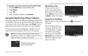
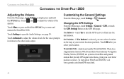
...for the voice prompts in relation to turn the GPS receiver off and use the unit indoors. see page 39. Changing the GPS Settings From the Menu page, touch Settings > General > GPS, or touch the GPS Settings button on the map as your location.... EGNOS, visit www.garmin.com/aboutGPS/waas.html. 38 StreetPilot 2820 Owner's Manual Touch Settings to adjust the volume of satellites and ground stations that provide GPS signal corrections, giving you select your current location (position). Customizing the StreetPilot 2820 Customizing the StreetPilot 2820 Adjusting the Volume From...
...for the voice prompts in relation to turn the GPS receiver off and use the unit indoors. see page 39. Changing the GPS Settings From the Menu page, touch Settings > General > GPS, or touch the GPS Settings button on the map as your location.... EGNOS, visit www.garmin.com/aboutGPS/waas.html. 38 StreetPilot 2820 Owner's Manual Touch Settings to adjust the volume of satellites and ground stations that provide GPS signal corrections, giving you select your current location (position). Customizing the StreetPilot 2820 Customizing the StreetPilot 2820 Adjusting the Volume From...
Owner's Manual
Page 54
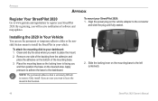
...to leave the mount in your StreetPilot 2820: 1. To mount your vehicle. To attach the mounting disk to your StreetPilot 2820. Slide the locking lever on the bottom of software and map updates. Note: The permanent adhesive disk is facing you will receive notification of the mounting base. 3....so the locking lever is extremely difficult to remove. Align the power plug on the cleaned area. Appendix Appendix Register Your StreetPilot 2820 Go to www.garmin.com/registration/ to register your dashboard: 1. By registering, you and then position the base on the vehicle adapter to ...
...to leave the mount in your StreetPilot 2820: 1. To mount your vehicle. To attach the mounting disk to your StreetPilot 2820. Slide the locking lever on the bottom of software and map updates. Note: The permanent adhesive disk is facing you will receive notification of the mounting base. 3....so the locking lever is extremely difficult to remove. Align the power plug on the cleaned area. Appendix Appendix Register Your StreetPilot 2820 Go to www.garmin.com/registration/ to register your dashboard: 1. By registering, you and then position the base on the vehicle adapter to ...

Owner's Manual
Page 62
... different from that to radio or television reception, which the receiver is protected under Part 15 regulations. 54 Software License Agreement BY USING THE STREETPILOT 2820, YOU AGREE TO BE BOUND BY THE TERMS AND CONDITIONS OF THE FOLLOWING SOFTWARE LICENSE AGREEMENT. Declaration of Garmin and is connected. • Consult an experienced radio/TV...
... different from that to radio or television reception, which the receiver is protected under Part 15 regulations. 54 Software License Agreement BY USING THE STREETPILOT 2820, YOU AGREE TO BE BOUND BY THE TERMS AND CONDITIONS OF THE FOLLOWING SOFTWARE LICENSE AGREEMENT. Declaration of Garmin and is connected. • Consult an experienced radio/TV...

Owner's Manual
Page 65
... T technical specifications 50 text language 39 time format 40 time zone 40 touch screen calibrating 45 cleaning vi TourGuide playing files 49 StreetPilot 2820 Owner's Manual 57 Index K keyboard, on keyboard 39 latitude coordinates 9 license agreement 54 locations editing 11 finding 5-7 saving 8 ...the active route 19 screen settings 45 serial number i set position 38 signal strength mobile phone 33 satellite 3, 15 traffic receiver 36 software license agreement 54 software version 45 speaker volume 38 specifications 50 speed (speedometer) 14 spell 6 stocks 53 stops...
... T technical specifications 50 text language 39 time format 40 time zone 40 touch screen calibrating 45 cleaning vi TourGuide playing files 49 StreetPilot 2820 Owner's Manual 57 Index K keyboard, on keyboard 39 latitude coordinates 9 license agreement 54 locations editing 11 finding 5-7 saving 8 ...the active route 19 screen settings 45 serial number i set position 38 signal strength mobile phone 33 satellite 3, 15 traffic receiver 36 software license agreement 54 software version 45 speaker volume 38 specifications 50 speed (speedometer) 14 spell 6 stocks 53 stops...

Owner's Manual
Page 66
Index settings 40 track log 21 track up 41 traffic 36-37 add subscription 37 avoid 36 incidents 36 transferring files to your StreetPilot 23 trip computer 14 troubleshooting 53 USB 51 turn list 14 U unit ID FM Traffic Receiver 45 Navigator III 45 unit keys 2 unplug USB 24 USB 22, 24 mass storage 23, 24 use indoors 38 V vehicle type 44 via points 18 viewing the map 13 voice dial 34 58 voice language 39 volume 38 speed-adjusted 40 W weather 53 WebUpdater 25 Where To? 5-7 X xImage 25 Y yellow diamond 36 Z zoom 13, 14 StreetPilot 2820 Owner's Manual
Index settings 40 track log 21 track up 41 traffic 36-37 add subscription 37 avoid 36 incidents 36 transferring files to your StreetPilot 23 trip computer 14 troubleshooting 53 USB 51 turn list 14 U unit ID FM Traffic Receiver 45 Navigator III 45 unit keys 2 unplug USB 24 USB 22, 24 mass storage 23, 24 use indoors 38 V vehicle type 44 via points 18 viewing the map 13 voice dial 34 58 voice language 39 volume 38 speed-adjusted 40 W weather 53 WebUpdater 25 Where To? 5-7 X xImage 25 Y yellow diamond 36 Z zoom 13, 14 StreetPilot 2820 Owner's Manual

Quick Reference Guide
Page 2
...enclosed USB Driver DVD-ROM into your current location. More Information For more information about the StreetPilot 2820, refer to scroll through the Menu page, Tools menu, and Settings menu. Press repeatedly ...Press repeatedly to an available USB port on and off. ➏ Infrared (IR) window-receives remote control signals. Press in and out. Touch the Speed or Arrival data field.... Touch Source to change the 2820 to view different parts of the map. Double-click the My Computer icon on your computer's desktop. "GARMIN" is very similar to playing ...
...enclosed USB Driver DVD-ROM into your current location. More Information For more information about the StreetPilot 2820, refer to scroll through the Menu page, Tools menu, and Settings menu. Press repeatedly ...Press repeatedly to an available USB port on and off. ➏ Infrared (IR) window-receives remote control signals. Press in and out. Touch the Speed or Arrival data field.... Touch Source to change the 2820 to view different parts of the map. Double-click the My Computer icon on your computer's desktop. "GARMIN" is very similar to playing ...


