Important Safety and Product Information
Page 2
...chemicals known to the State of certain electronics. Operating or watching the video input while the boat is prohibitively expensive. See www.garmin.com/prop65 for any discrepancies or questions before continuing navigation. • Use the electronic chart in product literature and copyright messages ... cause an accident or collision resulting in property damage, serious injury, or death. • NOTE: Refer to your product's owner's manual to determine if your product contains or accepts maps, or to determine if your product has video input capability. For safety, always resolve...
...chemicals known to the State of certain electronics. Operating or watching the video input while the boat is prohibitively expensive. See www.garmin.com/prop65 for any discrepancies or questions before continuing navigation. • Use the electronic chart in product literature and copyright messages ... cause an accident or collision resulting in property damage, serious injury, or death. • NOTE: Refer to your product's owner's manual to determine if your product contains or accepts maps, or to determine if your product has video input capability. For safety, always resolve...
Installation Instructions
Page 5
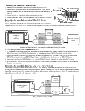
...Device To connect the power/data cable to the positive voltage terminal. (If you use NMEA 0183 data (standard or high-speed). See the GPSMAP 700 Series Owner's Manual for wire identification. 2. Connecting the Power/Data cable to a NMEA 0183 Device (Optional) You can be wired for the chartplotter to limit...ground on the fuse block of your NMEA 0183 device. Connecting the Power/Data Cable to determine the polarity of the voltage source. 2. For Garmin devices, the ground (black) wires serve as NMEA 0183 ground and must be attached together or on the same terminal as shown on the ...
...Device To connect the power/data cable to the positive voltage terminal. (If you use NMEA 0183 data (standard or high-speed). See the GPSMAP 700 Series Owner's Manual for wire identification. 2. Connecting the Power/Data cable to a NMEA 0183 Device (Optional) You can be wired for the chartplotter to limit...ground on the fuse block of your NMEA 0183 device. Connecting the Power/Data Cable to determine the polarity of the voltage source. 2. For Garmin devices, the ground (black) wires serve as NMEA 0183 ground and must be attached together or on the same terminal as shown on the ...

Quick Reference Guide
Page 2
... to an MOB Location When you mark your current location as a waypoint, you reach the end of Garmin Ltd. Review the course indicated by touching Mark at a Different Location 1. Garmin®, the Gamin logo, GPSMAP®, BlueChart®, and g2 Vision® are trademarks of the heading line. 4. or its subsidiaries... Guidance line. Complete an action: • Select Go To. • Select Route To. • Select Guide To to switch between Auto and Manual mode. This is based on the right side of the BlueChart g2 Vision data card is due to navigate. Go to open the Display screen...
... to an MOB Location When you mark your current location as a waypoint, you reach the end of Garmin Ltd. Review the course indicated by touching Mark at a Different Location 1. Garmin®, the Gamin logo, GPSMAP®, BlueChart®, and g2 Vision® are trademarks of the heading line. 4. or its subsidiaries... Guidance line. Complete an action: • Select Go To. • Select Route To. • Select Guide To to switch between Auto and Manual mode. This is based on the right side of the BlueChart g2 Vision data card is due to navigate. Go to open the Display screen...
Owner's Manual
Page 1
GPSMAP® 700 series owner's manual
GPSMAP® 700 series owner's manual

Owner's Manual
Page 2
... commercial distribution of this manual or any person or organization of Garmin. or its subsidiaries All rights reserved. These trademarks may be used without the express prior written consent of XM Satellite Radio Inc. Garmin®, the Garmin logo, GPSMAP®, BlueChart®, g2... Vision®, and MapSource® are registered trademarks of Garmin. Visit the Garmin Web site (www.garmin.com) for any purpose without the express permission of ...
... commercial distribution of this manual or any person or organization of Garmin. or its subsidiaries All rights reserved. These trademarks may be used without the express prior written consent of XM Satellite Radio Inc. Garmin®, the Garmin logo, GPSMAP®, BlueChart®, g2... Vision®, and MapSource® are registered trademarks of Garmin. Visit the Garmin Web site (www.garmin.com) for any purpose without the express permission of ...
Owner's Manual
Page 3
... should touch Charts and then touch Navigation Chart. Small arrows (>) in the product box for the following products: • GPSMAP® 720/720s • GPSMAP 740/740s • GPSMAP 750/750s Tips and Shortcuts • Select Home from any screen to return to the Home screen. • Select Menu...adjust the Backlight and Color Mode settings. • Press and hold to select it. This manual includes information for product warnings and other important information. Manual Conventions In this manual, when you are instructed to select an item, use your finger to touch that you should...
... should touch Charts and then touch Navigation Chart. Small arrows (>) in the product box for the following products: • GPSMAP® 720/720s • GPSMAP 740/740s • GPSMAP 750/750s Tips and Shortcuts • Select Home from any screen to return to the Home screen. • Select Menu...adjust the Backlight and Color Mode settings. • Press and hold to select it. This manual includes information for product warnings and other important information. Manual Conventions In this manual, when you are instructed to select an item, use your finger to touch that you should...

Owner's Manual
Page 4
...22 Combination Screen Configuration 22 Navigation 25 Basic Navigation Questions 25 Navigation with a Chartplotter 25 Waypoints 26 Routes 28 Tracks 30 Navigating with a Garmin Autopilot 32 Where To 33 Marine Services Destinations 33 Almanac, On-boat, and Environmental Data 36 Almanac Data 36 On-boat Data 38 ...GPS Satellite Locations 85 Using WAAS/EGNOS 85 System Information 85 NMEA 0183 and NMEA 2000 86 Registering Your Device 89 Contacting Garmin Product Support 89 Declaration of Conformity 89 Software License Agreement 89 Index 90 ii GPSMAP 700 Series Owner's Manual
...22 Combination Screen Configuration 22 Navigation 25 Basic Navigation Questions 25 Navigation with a Chartplotter 25 Waypoints 26 Routes 28 Tracks 30 Navigating with a Garmin Autopilot 32 Where To 33 Marine Services Destinations 33 Almanac, On-boat, and Environmental Data 36 Almanac Data 36 On-boat Data 38 ...GPS Satellite Locations 85 Using WAAS/EGNOS 85 System Information 85 NMEA 0183 and NMEA 2000 86 Registering Your Device 89 Contacting Garmin Product Support 89 Declaration of Conformity 89 Software License Agreement 89 Index 90 ii GPSMAP 700 Series Owner's Manual
Owner's Manual
Page 5
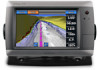
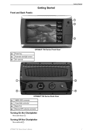
Front and Back Panels Getting Started Getting Started ➊ ➋ ➌ GPSMAP 700 Series Front View ➊ Power key ➋ Automatic backlight sensor ➌ SD card slot ➊ ➌ GPSMAP 700 Series Back View ➊ NMEA 2000 connector ➋ Power/data connector ➌ Radar Port ➍ External GPS antenna connector Turning On the Chartplotter Press and release . Turning Off the Chartplotter Press and hold . GPSMAP 700 Series Owner's Manual ➋ ➍ 1
Front and Back Panels Getting Started Getting Started ➊ ➋ ➌ GPSMAP 700 Series Front View ➊ Power key ➋ Automatic backlight sensor ➌ SD card slot ➊ ➌ GPSMAP 700 Series Back View ➊ NMEA 2000 connector ➋ Power/data connector ➌ Radar Port ➍ External GPS antenna connector Turning On the Chartplotter Press and release . Turning Off the Chartplotter Press and hold . GPSMAP 700 Series Owner's Manual ➋ ➍ 1
Owner's Manual
Page 6
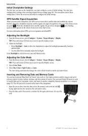
... front of interest. For more information about GPS, go to switch between Auto and Manual mode. From the Home screen, select Configure > System > Beeper/Display > Display. Select Backlight to www.garmin.com/aboutGPS. From the Home screen, select Configure > System > Beeper/Display > ...Display. The Auto setting automatically changes the color scheme based on the chart screen. TIP: Press and release from any screen to eject the card. ➊ 2 GPSMAP 700 Series Owner's Manual Adjusting ...
... front of interest. For more information about GPS, go to switch between Auto and Manual mode. From the Home screen, select Configure > System > Beeper/Display > Display. Select Backlight to www.garmin.com/aboutGPS. From the Home screen, select Configure > System > Beeper/Display > ...Display. The Auto setting automatically changes the color scheme based on the chart screen. TIP: Press and release from any screen to eject the card. ➊ 2 GPSMAP 700 Series Owner's Manual Adjusting ...
Owner's Manual
Page 7
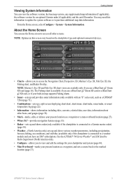
...-in map supports Fishing charts. • Sonar-sets up and provides sonar information (only available with an "S" series unit, such as a GPSMAP 720s) (page 71). • Combinations-sets up and shows various weather parameters, including precipitation, forecast, fishing, sea conditions, and visibility (available ... System Information You can use the Home screen to view and edit the settings for an optional Garmin radar (if applicable), and the unit ID number. GPSMAP 700 Series Owner's Manual 3 From the Home screen, select Configure > System > System Information. You may need this ...
...-in map supports Fishing charts. • Sonar-sets up and provides sonar information (only available with an "S" series unit, such as a GPSMAP 720s) (page 71). • Combinations-sets up and shows various weather parameters, including precipitation, forecast, fishing, sea conditions, and visibility (available ... System Information You can use the Home screen to view and edit the settings for an optional Garmin radar (if applicable), and the unit ID number. GPSMAP 700 Series Owner's Manual 3 From the Home screen, select Configure > System > System Information. You may need this ...
Owner's Manual
Page 8
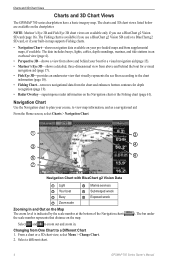
...'s Eye 3D and Fish Eye 3D chart views are available on the map. Select a different chart. ). The bar under 4 GPSMAP 700 Series Owner's Manual The Fishing chart is indicated by the scale number at the bottom of the Navigation chart ( the scale number represents that visually represents...a BlueChart g2 Vision SD card (page 16). Changing from supplemental maps, if available. Charts and 3D Chart Views Charts and 3D Chart Views The GPSMAP 700 series chartplotters have a basic imagery map. Select and to zoom out and zoom in an overhead view (page 4). • Perspective 3D-shows...
...'s Eye 3D and Fish Eye 3D chart views are available on the map. Select a different chart. ). The bar under 4 GPSMAP 700 Series Owner's Manual The Fishing chart is indicated by the scale number at the bottom of the Navigation chart ( the scale number represents that visually represents...a BlueChart g2 Vision SD card (page 16). Changing from supplemental maps, if available. Charts and 3D Chart Views Charts and 3D Chart Views The GPSMAP 700 series chartplotters have a basic imagery map. Select and to zoom out and zoom in an overhead view (page 4). • Perspective 3D-shows...
Owner's Manual
Page 9
... lines (with deep water represented in map supports Fishing charts. Select Stop Panning to stop panning and return the screen to , those shown below. GPSMAP 700 Series Owner's Manual 5 Navigating to a Point on the Chart CAUTION The Auto Guidance feature of the map, the screen scrolls forward to denote map features...
... lines (with deep water represented in map supports Fishing charts. Select Stop Panning to stop panning and return the screen to , those shown below. GPSMAP 700 Series Owner's Manual 5 Navigating to a Point on the Chart CAUTION The Auto Guidance feature of the map, the screen scrolls forward to denote map features...
Owner's Manual
Page 10
.... 4. From the Home screen, select Charts. 2. A list of options appears along the right side of the screen. Select a chart or a 3D chart view. 6 GPSMAP 700 Series Owner's Manual The information appears in the vicinity of the cursor. (Review does not appear if the cursor is near only one object, the name of...
.... 4. From the Home screen, select Charts. 2. A list of options appears along the right side of the screen. Select a chart or a 3D chart view. 6 GPSMAP 700 Series Owner's Manual The information appears in the vicinity of the cursor. (Review does not appear if the cursor is near only one object, the name of...
Owner's Manual
Page 11
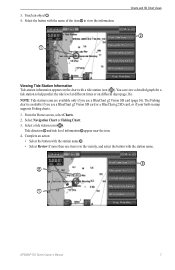
... supports Fishing charts. 1. From the Home screen, select Charts. 2. Touch an object ➊. 4. Select the button with the station name. ➌ ➋ ➊ GPSMAP 700 Series Owner's Manual 7 Complete an action: • Select the button with the station name ➌. • Select Review if more than one item is available if you...
... supports Fishing charts. 1. From the Home screen, select Charts. 2. Touch an object ➊. 4. Select the button with the station name. ➌ ➋ ➊ GPSMAP 700 Series Owner's Manual 7 Complete an action: • Select the button with the station name ➌. • Select Review if more than one item is available if you...
Owner's Manual
Page 12
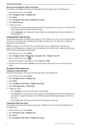
..., lights, and obstructions. Select Menu. 4. From the Home screen, select Charts. 2. Select Chart Appearance > Orientation. 6. Select Navigation Chart Setup or Fishing Chart Setup. 8 GPSMAP 700 Series Owner's Manual Select Tides/Currents. 6. Navigation Chart Appearance Changing the Map Orientation You can view details about Navaids From the Navigation chart, the Fishing chart, Perspective...
..., lights, and obstructions. Select Menu. 4. From the Home screen, select Charts. 2. Select Chart Appearance > Orientation. 6. Select Navigation Chart Setup or Fishing Chart Setup. 8 GPSMAP 700 Series Owner's Manual Select Tides/Currents. 6. Navigation Chart Appearance Changing the Map Orientation You can view details about Navaids From the Navigation chart, the Fishing chart, Perspective...

Owner's Manual
Page 13
...heading line for the Navigation chart or the Fishing chart. Select Menu. 4. You can use a BlueChart g2 Vision SD card. GPSMAP 700 Series Owner's Manual 9 Select Chart Appearance > Detail. 6. Selecting a World Map You can configure the appearance of the heading line, and select Done.... The Fishing chart is available if you use either a basic world map or a shaded relief map on all GPSMAP 700 series chartplotters. 1. ...
...heading line for the Navigation chart or the Fishing chart. Select Menu. 4. You can use a BlueChart g2 Vision SD card. GPSMAP 700 Series Owner's Manual 9 Select Chart Appearance > Detail. 6. Selecting a World Map You can configure the appearance of the heading line, and select Done.... The Fishing chart is available if you use either a basic world map or a shaded relief map on all GPSMAP 700 series chartplotters. 1. ...
Owner's Manual
Page 14
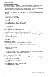
... Soundings On the Navigation Chart, you can show and configure the appearance of depth shading on the Navigation chart. Select Chart Appearance > Symbols. 10 GPSMAP 700 Series Owner's Manual Select Spot Depths > Dangerous. 3. Enter the dangerous depth. 4. Charts and 3D Chart Views Selecting the Heading Line Source The source for the display...
... Soundings On the Navigation Chart, you can show and configure the appearance of depth shading on the Navigation chart. Select Chart Appearance > Symbols. 10 GPSMAP 700 Series Owner's Manual Select Spot Depths > Dangerous. 3. Enter the dangerous depth. 4. Charts and 3D Chart Views Selecting the Heading Line Source The source for the display...
Owner's Manual
Page 15
... set on the zoom level. • Select Photo Points > On to the heading of rose (Compass, True Wind, or Apparent Wind). ➋ ➊ GPSMAP 700 Series Owner's Manual 11 Showing Additional Chart Details You can show camera icons when using a BlueChart g2 Vision data card. From the Home screen, select Charts > Navigation...
... set on the zoom level. • Select Photo Points > On to the heading of rose (Compass, True Wind, or Apparent Wind). ➋ ➊ GPSMAP 700 Series Owner's Manual 11 Showing Additional Chart Details You can show camera icons when using a BlueChart g2 Vision data card. From the Home screen, select Charts > Navigation...
Owner's Manual
Page 16
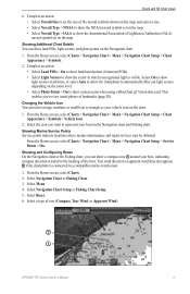
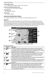
Using Tracks See "Tracks" (page 30). If the AIS transmission from the vessel is lost, a message banner appears. 12 GPSMAP 700 Series Owner's Manual The vessel is pointing indicates the direction in range. If the AIS transmission from the vessel is lost . About AIS AIS alerts you to identify ...
Using Tracks See "Tracks" (page 30). If the AIS transmission from the vessel is lost, a message banner appears. 12 GPSMAP 700 Series Owner's Manual The vessel is pointing indicates the direction in range. If the AIS transmission from the vessel is lost . About AIS AIS alerts you to identify ...

Owner's Manual
Page 17
... of the target appears on a chart or a 3D chart view. All AIS functionality on all 3D chart views is also based on a 3D chart view. GPSMAP 700 Series Owner's Manual 13
... of the target appears on a chart or a 3D chart view. All AIS functionality on all 3D chart views is also based on a 3D chart view. GPSMAP 700 Series Owner's Manual 13

