Quick Reference Guide
Page 1
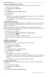
...steering to avoid land, shallow water, and other obstacles. It should be in your path. Enter the name of the Bluechart g2 Vision data card is closest to your destination ( ). 6. When using the cursor ( ). 4. Use visual sightings and steer ...GPSMAP® 700 series quick reference guide Creating and Navigating a Route Creating and Navigating a Route from Your Present Location You can choose to save the route. 11.Complete an action: • Select No • Select Yes > Edit Route > Name. Note: The Fishing chart is available with a preprogrammed BlueChart g2 Vision...
...steering to avoid land, shallow water, and other obstacles. It should be in your path. Enter the name of the Bluechart g2 Vision data card is closest to your destination ( ). 6. When using the cursor ( ). 4. Use visual sightings and steer ...GPSMAP® 700 series quick reference guide Creating and Navigating a Route Creating and Navigating a Route from Your Present Location You can choose to save the route. 11.Complete an action: • Select No • Select Yes > Edit Route > Name. Note: The Fishing chart is available with a preprogrammed BlueChart g2 Vision...

Quick Reference Guide
Page 2
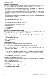
... permission of the 50 nearest locations and the distance and bearing to all visual sightings and avoid any other dangerous objects. Garmin®, the Gamin logo, GPSMAP®, BlueChart®, and g2 Vision® are trademarks of the screen and select Edit Waypoint. 6. B Printed in Taiwan Select Create Waypoint. 5. NOTE: Select Auto to show...
... permission of the 50 nearest locations and the distance and bearing to all visual sightings and avoid any other dangerous objects. Garmin®, the Gamin logo, GPSMAP®, BlueChart®, and g2 Vision® are trademarks of the screen and select Edit Waypoint. 6. B Printed in Taiwan Select Create Waypoint. 5. NOTE: Select Auto to show...

Owner's Manual
Page 2
... strictly prohibited. These trademarks may be used without obligation to change without the express prior written consent of Garmin Ltd. Garmin®, the Garmin logo, GPSMAP®, BlueChart®, g2 Vision®, and MapSource® are trademarks of Garmin. or its products and to change or improve its subsidiaries, registered in the United States and other electronic...
... strictly prohibited. These trademarks may be used without obligation to change without the express prior written consent of Garmin Ltd. Garmin®, the Garmin logo, GPSMAP®, BlueChart®, g2 Vision®, and MapSource® are trademarks of Garmin. or its products and to change or improve its subsidiaries, registered in the United States and other electronic...

Owner's Manual
Page 4
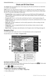
... 3 Charts and 3D Chart Views 4 Navigation Chart 4 Automatic Identification System 12 Perspective 3D 15 BlueChart g2 Vision 16 Mariner's Eye 3D 17 Fish Eye 3D 18 Fishing Chart 19 Showing Satellite Imagery on the Navigation... Navigation Questions 25 Navigation with a Chartplotter 25 Waypoints 26 Routes 28 Tracks 30 Navigating with a Garmin Autopilot 32 Where To 33 Marine Services Destinations 33 Almanac, On-boat, and Environmental Data 36...86 Registering Your Device 89 Contacting Garmin Product Support 89 Declaration of Conformity 89 Software License Agreement 89 Index 90 ii...
... 3 Charts and 3D Chart Views 4 Navigation Chart 4 Automatic Identification System 12 Perspective 3D 15 BlueChart g2 Vision 16 Mariner's Eye 3D 17 Fish Eye 3D 18 Fishing Chart 19 Showing Satellite Imagery on the Navigation... Navigation Questions 25 Navigation with a Chartplotter 25 Waypoints 26 Routes 28 Tracks 30 Navigating with a Garmin Autopilot 32 Where To 33 Marine Services Destinations 33 Almanac, On-boat, and Environmental Data 36...86 Registering Your Device 89 Contacting Garmin Product Support 89 Declaration of Conformity 89 Software License Agreement 89 Index 90 ii...
Owner's Manual
Page 6
... > Beeper/Display > Display. TIP: Press and release from any screen to eject the card. ➊ 2 GPSMAP 700 Series Owner's Manual You can update each of the chartplotter. • Open the access door, insert the ... Color Mode. 3. Follow the on the chart screen. TIP: Press and release from any screen to another compatible Garmin chartplotter or a computer (page 52). When the chartplotter acquires satellite signals, the signal strength bars at the top...and Memory Cards You can insert optional BlueChart® g2 Vision® data cards to configure the initial settings.
... > Beeper/Display > Display. TIP: Press and release from any screen to eject the card. ➊ 2 GPSMAP 700 Series Owner's Manual You can update each of the chartplotter. • Open the access door, insert the ... Color Mode. 3. Follow the on the chart screen. TIP: Press and release from any screen to another compatible Garmin chartplotter or a computer (page 52). When the chartplotter acquires satellite signals, the signal strength bars at the top...and Memory Cards You can insert optional BlueChart® g2 Vision® data cards to configure the initial settings.
Owner's Manual
Page 7
...chart is available if you use a BlueChart g2 Vision SD card or a BlueChart g2 SD card, or if your built-in map supports Fishing charts. • Sonar-sets up and provides sonar information (only available with an "S" series unit, such as a GPSMAP 720s) (page 71). • Combinations-sets ...; Where To?-provides navigation features (page 33). • Radar-sets up and shows radar (only available if the chartplotter is connected to a Garmin marine radar) (page 54). • Weather-(North America only) sets up and shows various weather parameters, including precipitation, forecast, fishing, sea ...
...chart is available if you use a BlueChart g2 Vision SD card or a BlueChart g2 SD card, or if your built-in map supports Fishing charts. • Sonar-sets up and provides sonar information (only available with an "S" series unit, such as a GPSMAP 720s) (page 71). • Combinations-sets ...; Where To?-provides navigation features (page 33). • Radar-sets up and shows radar (only available if the chartplotter is connected to a Garmin marine radar) (page 54). • Weather-(North America only) sets up and shows various weather parameters, including precipitation, forecast, fishing, sea ...
Owner's Manual
Page 8
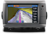
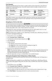
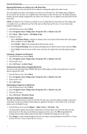
... From the Home screen, select Charts > Navigation Chart. ➊ ➋ ➌ ➍ ➎ ➏ ➐ Navigation Chart with BlueChart g2 Vision Data ➊ Light ➋ Marina services ➌ Your boat ➍ Submerged wreck ➎ Buoy ➏ Exposed wreck ➐ Zoom scale Zooming...a Different Chart 1. The data includes buoys, lights, cables, depth soundings, marinas, and tide stations in . The bar under 4 GPSMAP 700 Series Owner's Manual Select a different chart. ). Note: Mariner's Eye 3D and Fish Eye 3D chart views are available on ...
... From the Home screen, select Charts > Navigation Chart. ➊ ➋ ➌ ➍ ➎ ➏ ➐ Navigation Chart with BlueChart g2 Vision Data ➊ Light ➋ Marina services ➌ Your boat ➍ Submerged wreck ➎ Buoy ➏ Exposed wreck ➐ Zoom scale Zooming...a Different Chart 1. The data includes buoys, lights, cables, depth soundings, marinas, and tide stations in . The bar under 4 GPSMAP 700 Series Owner's Manual Select a different chart. ). Note: Mariner's Eye 3D and Fish Eye 3D chart views are available on ...
Owner's Manual
Page 9
... Guidance, a gray segment within any land, shallow water, or other areas on electronic chart information. GPSMAP 700 Series Owner's Manual 5 When you use a BlueChart g2 Vision SD card or a BlueChart g2 SD card, or if your built-in map supports Fishing charts. That data does not ensure obstacle...include depth contour lines (with deep water represented in map supports Fishing charts. 1. Charts and 3D Chart Views Chart Symbols BlueChart g2 and BlueChart g2 Vision charts use graphic symbols to pan the map. The radar overlay is based on the Navigation chart, the Fishing chart, or...
... Guidance, a gray segment within any land, shallow water, or other areas on electronic chart information. GPSMAP 700 Series Owner's Manual 5 When you use a BlueChart g2 Vision SD card or a BlueChart g2 SD card, or if your built-in map supports Fishing charts. That data does not ensure obstacle...include depth contour lines (with deep water represented in map supports Fishing charts. 1. Charts and 3D Chart Views Chart Symbols BlueChart g2 and BlueChart g2 Vision charts use graphic symbols to pan the map. The radar overlay is based on the Navigation chart, the Fishing chart, or...
Owner's Manual
Page 10
...Information to measure from the screen. Showing or Hiding Colored Tracks You can view information about on the location or object you use a BlueChart g2 Vision SD card (page 16). Touch a location or an object. Select Set Reference to view tide (page 36), current (page 37), celestial... does not appear if the cursor is available if you selected. 4. The options that color. Select a chart or a 3D chart view. 6 GPSMAP 700 Series Owner's Manual Select a waypoint symbol. 5. Viewing Location and Object Information on a Chart You can specify the color of tracks (page 31...
...Information to measure from the screen. Showing or Hiding Colored Tracks You can view information about on the location or object you use a BlueChart g2 Vision SD card (page 16). Touch a location or an object. Select Set Reference to view tide (page 36), current (page 37), celestial... does not appear if the cursor is available if you selected. 4. The options that color. Select a chart or a 3D chart view. 6 GPSMAP 700 Series Owner's Manual Select a waypoint symbol. 5. Viewing Location and Object Information on a Chart You can specify the color of tracks (page 31...
Owner's Manual
Page 11
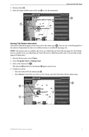
...• Select the button with the station name ➌. • Select Review if more than one item is available if you use a BlueChart g2 Vision SD card or a BlueChart g2 SD card, or if your built-in the vicinity, and select the button with a tide station icon ( ). 3. The Fishing chart is in ...of the item ➋ to help predict the tide level at different times or on the chart with the station name. ➌ ➋ ➊ GPSMAP 700 Series Owner's Manual 7 Tide direction ➊ and tide level information ➋ appear near the icon. 4. Touch an object ➊. 4.
...• Select the button with the station name ➌. • Select Review if more than one item is available if you use a BlueChart g2 Vision SD card or a BlueChart g2 SD card, or if your built-in the vicinity, and select the button with a tide station icon ( ). 3. The Fishing chart is in ...of the item ➋ to help predict the tide level at different times or on the chart with the station name. ➌ ➋ ➊ GPSMAP 700 Series Owner's Manual 7 Tide direction ➊ and tide level information ➋ appear near the icon. 4. Touch an object ➊. 4.
Owner's Manual
Page 12
...aids, including beacons, lights, and obstructions. Select Navigation Chart or Fishing Chart. 3. Select Navigation Chart Setup or Fishing Chart Setup. 8 GPSMAP 700 Series Owner's Manual Charts and 3D Chart Views Showing and Configuring Tides and Currents You can show animated tide station indicators and animated ...Map Zoom Detail You can set the top of the map to a north heading. • Select Head Up to use a BlueChart g2 Vision SD card or a BlueChart g2 SD card, or if your built-in the Navigation chart or the Fishing chart. 1. From the Home screen, select Charts. 2. ...
...aids, including beacons, lights, and obstructions. Select Navigation Chart or Fishing Chart. 3. Select Navigation Chart Setup or Fishing Chart Setup. 8 GPSMAP 700 Series Owner's Manual Charts and 3D Chart Views Showing and Configuring Tides and Currents You can show animated tide station indicators and animated ...Map Zoom Detail You can set the top of the map to a north heading. • Select Head Up to use a BlueChart g2 Vision SD card or a BlueChart g2 SD card, or if your built-in the Navigation chart or the Fishing chart. 1. From the Home screen, select Charts. 2. ...

Owner's Manual
Page 13
...Chart Views 5. Select Chart Appearance > Detail. 6. Heading Line 1. Select Chart Appearance > Heading Line > Display. 6. GPSMAP 700 Series Owner's Manual 9 You can use a BlueChart g2 Vision SD card or a BlueChart g2 SD card, or if your built-in the direction of the heading line for the Navigation chart or the... Fishing chart. Use the slider bar to show basic map data on all GPSMAP 700 series chartplotters. 1. From...
...Chart Views 5. Select Chart Appearance > Detail. 6. Heading Line 1. Select Chart Appearance > Heading Line > Display. 6. GPSMAP 700 Series Owner's Manual 9 You can use a BlueChart g2 Vision SD card or a BlueChart g2 SD card, or if your built-in the direction of the heading line for the Navigation chart or the... Fishing chart. Use the slider bar to show basic map data on all GPSMAP 700 series chartplotters. 1. From...
Owner's Manual
Page 14
...available from a heading sensor, both the heading line and the vehicle icon will be indicated by red text. 1. Select Chart Appearance > Symbols. 10 GPSMAP 700 Series Owner's Manual Select Chart Appearance > Heading Line > Source. 6. The contour is always drawn at, or deeper than , the dangerous ...of the heading line on the chart with depths shallower than the specified value are shaded in blue, while areas with a preprogrammed BlueChart g2 Vision data card. 1. Areas on the chartplotter is determined by the heading line source setting (Auto or GPS Hdg) and whether heading ...
...available from a heading sensor, both the heading line and the vehicle icon will be indicated by red text. 1. Select Chart Appearance > Symbols. 10 GPSMAP 700 Series Owner's Manual Select Chart Appearance > Heading Line > Source. 6. The contour is always drawn at, or deeper than , the dangerous ...of the heading line on the chart with depths shallower than the specified value are shaded in blue, while areas with a preprogrammed BlueChart g2 Vision data card. 1. Areas on the chartplotter is determined by the heading line source setting (Auto or GPS Hdg) and whether heading ...
Owner's Manual
Page 15
...2. Select Menu. 4. Select a type of landmarks (page 20). Showing Additional Chart Details You can show camera icons when using a BlueChart g2 Vision data card. Select On to show light sectors at all times, or select Auto to allow the chartplotter to automatically filter out light sectors ...which a navigational light is connected to view aerial photos of rose (Compass, True Wind, or Apparent Wind). ➋ ➊ GPSMAP 700 Series Owner's Manual 11 Showing Marine Service Points Service points indicate locations where marine maintenance and repair services may be obtained. Select...
...2. Select Menu. 4. Select a type of landmarks (page 20). Showing Additional Chart Details You can show camera icons when using a BlueChart g2 Vision data card. Select On to show light sectors at all times, or select Auto to allow the chartplotter to automatically filter out light sectors ...which a navigational light is connected to view aerial photos of rose (Compass, True Wind, or Apparent Wind). ➋ ➊ GPSMAP 700 Series Owner's Manual 11 Showing Marine Service Points Service points indicate locations where marine maintenance and repair services may be obtained. Select...
Owner's Manual
Page 18
.... • Select Projected Heading, enter the projected heading time for one chart or one 3D chart view is available if you use a BlueChart g2 Vision SD card. Select a distance or select Show All. • Select Details > Show to the Radar Overlay. 1. Select Navigation Chart, Fishing...Vessel. The details, projected heading, and trails settings configured for AIS-activated vessels, and select Done. • Select Trails to 2.0 mi.). 14 GPSMAP 700 Series Owner's Manual You can view the AIS signal status, MMSI, GPS speed, GPS heading, and other vessels. Touch an AIS vessel....
.... • Select Projected Heading, enter the projected heading time for one chart or one 3D chart view is available if you use a BlueChart g2 Vision SD card. Select a distance or select Show All. • Select Details > Show to the Radar Overlay. 1. Select Navigation Chart, Fishing...Vessel. The details, projected heading, and trails settings configured for AIS-activated vessels, and select Done. • Select Trails to 2.0 mi.). 14 GPSMAP 700 Series Owner's Manual You can view the AIS signal status, MMSI, GPS speed, GPS heading, and other vessels. Touch an AIS vessel....
Owner's Manual
Page 19
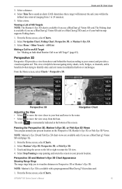
... (page 83). From the Home screen, select Charts. Select a time. Select Mariner's Eye 3D, Perspective 3D, or Fish Eye 3D. 3. GPSMAP 700 Series Owner's Manual 15 Viewing a List of the screen. Making a Call to an AIS Target See "Making an Individual Routine Call to rotate...bridges, or channels, and is momentarily indicated at the bottom of AIS Targets Note: The Mariner's Eye 3D chart is available with a preprogrammed BlueChart g2 Vision data card. 1. From the Home screen, select Charts. 2. The scale ( ) is beneficial when trying to your present location on the Perspective 3D...
... (page 83). From the Home screen, select Charts. Select a time. Select Mariner's Eye 3D, Perspective 3D, or Fish Eye 3D. 3. GPSMAP 700 Series Owner's Manual 15 Viewing a List of the screen. Making a Call to an AIS Target See "Making an Individual Routine Call to rotate...bridges, or channels, and is momentarily indicated at the bottom of AIS Targets Note: The Mariner's Eye 3D chart is available with a preprogrammed BlueChart g2 Vision data card. 1. From the Home screen, select Charts. 2. The scale ( ) is beneficial when trying to your present location on the Perspective 3D...

Owner's Manual
Page 20
... the original packaging for backup or viewing purposes. BlueChart g2 Vision data cards are not waterproof. In low-humidity environments, you are navigating. You can use the data card only on or off. 16 GPSMAP 700 Series Owner's Manual Charts and 3D Chart Views ...). Select Perspective 3D or Mariner's Eye 3D. 3. You can insert or remove a BlueChart g2 Vision data card (page 2) while your chartplotter. Note: Mariner's Eye 3D is on BlueChart g2 Vision-compatible Garmin GPS units or Garmin HomePort™. Enter the width. 5. Using Waypoints and Tracks See "Waypoints" (page 26)...
... the original packaging for backup or viewing purposes. BlueChart g2 Vision data cards are not waterproof. In low-humidity environments, you are navigating. You can use the data card only on or off. 16 GPSMAP 700 Series Owner's Manual Charts and 3D Chart Views ...). Select Perspective 3D or Mariner's Eye 3D. 3. You can insert or remove a BlueChart g2 Vision data card (page 2) while your chartplotter. Note: Mariner's Eye 3D is on BlueChart g2 Vision-compatible Garmin GPS units or Garmin HomePort™. Enter the width. 5. Using Waypoints and Tracks See "Waypoints" (page 26)...

Owner's Manual
Page 21
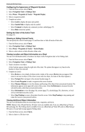
...Charts > Mariner's Eye 3D > Menu > Chart Appearance > Hazard Colors. 2. Mariner's Eye 3D, Hazard Colors Off Mariner's Eye 3D, Hazard Colors On GPSMAP 700 Series Owner's Manual 17 Showing or Hiding Hazard Colors 1. This view is very shallow water. • Select Off to your course) and provides a ...Range Rings Navigation Chart Adjusting the View See "Adjusting the View" (page 15). Charts and 3D Chart Views Mariner's Eye 3D A BlueChart g2 Vision data card offers Mariner's Eye 3D, which provides a detailed, three‑dimensional view from above and behind the boat (according to view the...
...Charts > Mariner's Eye 3D > Menu > Chart Appearance > Hazard Colors. 2. Mariner's Eye 3D, Hazard Colors Off Mariner's Eye 3D, Hazard Colors On GPSMAP 700 Series Owner's Manual 17 Showing or Hiding Hazard Colors 1. This view is very shallow water. • Select Off to your course) and provides a ...Range Rings Navigation Chart Adjusting the View See "Adjusting the View" (page 15). Charts and 3D Chart Views Mariner's Eye 3D A BlueChart g2 Vision data card offers Mariner's Eye 3D, which provides a detailed, three‑dimensional view from above and behind the boat (according to view the...

Owner's Manual
Page 22
... Guidance setting (page 46) or the sonar shallow water alarm setting (page 77). 1. Fish Eye 3D Using the depth contour lines of the BlueChart g2 Vision cartography, Fish Eye 3D provides an underwater view of a safe depth for Mariner's Eye 3D. Fish Eye 3D with a Sonar Cone Adjusting the View... See "Adjusting the View" (page 15). Select Fore, Aft, Port, or Starboard. 18 GPSMAP 700 Series Owner's Manual Red indicates the largest targets and green indicates the smallest. From the Home screen, select Charts > Fish Eye 3D > Menu > View...
... Guidance setting (page 46) or the sonar shallow water alarm setting (page 77). 1. Fish Eye 3D Using the depth contour lines of the BlueChart g2 Vision cartography, Fish Eye 3D provides an underwater view of a safe depth for Mariner's Eye 3D. Fish Eye 3D with a Sonar Cone Adjusting the View... See "Adjusting the View" (page 15). Select Fore, Aft, Port, or Starboard. 18 GPSMAP 700 Series Owner's Manual Red indicates the largest targets and green indicates the smallest. From the Home screen, select Charts > Fish Eye 3D > Menu > View...

Owner's Manual
Page 23
Showing Other Vessels See "Configuring the Appearance of the Navigation chart when using a preprogrammed BlueChart g2 Vision data card. NOTE: When enabled, high-resolution satellite images are present only at lower zoom levels. From the Home screen, select Charts > Navigation... Numbers" (page 48). Using Tracks See "Tracks" (page 30). GPSMAP 700 Series Owner's Manual 19 Showing Overlay Numbers See "Overlay Numbers" (page 48). You also can set the detail level higher by your BlueChart g2 Vision region, you can overlay high-resolution satellite images on the land or on...
Showing Other Vessels See "Configuring the Appearance of the Navigation chart when using a preprogrammed BlueChart g2 Vision data card. NOTE: When enabled, high-resolution satellite images are present only at lower zoom levels. From the Home screen, select Charts > Navigation... Numbers" (page 48). Using Tracks See "Tracks" (page 30). GPSMAP 700 Series Owner's Manual 19 Showing Overlay Numbers See "Overlay Numbers" (page 48). You also can set the detail level higher by your BlueChart g2 Vision region, you can overlay high-resolution satellite images on the land or on...


