Important Safety and Product Information
Page 2
... any interference received, including interference that may cause undesired operation. Prolonged submersion can withstand immersion in product literature and copyright messages displayed to fishfinders. Category II... radiocommunication devices comply with Industry Canada Standard RSS-210. Battery Warnings Your GPS unit may use a combination of... or attempt to remove the non-userreplaceable battery. • When disposing of Garmin is to us at a reasonable cost. The California Electronic Waste Recycling Act of...
... any interference received, including interference that may cause undesired operation. Prolonged submersion can withstand immersion in product literature and copyright messages displayed to fishfinders. Category II... radiocommunication devices comply with Industry Canada Standard RSS-210. Battery Warnings Your GPS unit may use a combination of... or attempt to remove the non-userreplaceable battery. • When disposing of Garmin is to us at a reasonable cost. The California Electronic Waste Recycling Act of...
Installation Instructions
Page 8
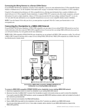
.... If more information. Using the CANet optimizes the performance of the T-connector you can receive sonar information from a sounder or fishfinder to be sent to share information with NMEA 2000 connectors or cables. Determine an appropriate location...Garmin dealer or marine dealer. Connecting the Wiring Harness to a Garmin CANet Device If your Garmin dealer, or visit www.garmin.com. A standard NMEA 0183 connection only allows depth, temperature, and speed information to be shared with your compatible Garmin sounder or fishfinder. NOTE: NMEA 2000-compatible GPSMAP...
.... If more information. Using the CANet optimizes the performance of the T-connector you can receive sonar information from a sounder or fishfinder to be sent to share information with NMEA 2000 connectors or cables. Determine an appropriate location...Garmin dealer or marine dealer. Connecting the Wiring Harness to a Garmin CANet Device If your Garmin dealer, or visit www.garmin.com. A standard NMEA 0183 connection only allows depth, temperature, and speed information to be shared with your compatible Garmin sounder or fishfinder. NOTE: NMEA 2000-compatible GPSMAP...
Owner's Manual
Page 63
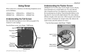
...received at the depth indicated. Sonar information flashes on a circular depth scale. Depth Temperature Speed Suspended targets Range Using Sonar Understanding the Flasher Screen (GPSMAP 431s/531s/536s only) Use the Flasher screen to display sonar information on the ring when it is beneath your boat. It is organized as fishfinders: GPSMAP 431s GPSMAP 441s GPSMAP... 531s GPSMAP 536s GPSMAP 541s GPSMAP 546s Understanding the Full Screen Select the Full Screen option to view a ...
...received at the depth indicated. Sonar information flashes on a circular depth scale. Depth Temperature Speed Suspended targets Range Using Sonar Understanding the Flasher Screen (GPSMAP 431s/531s/536s only) Use the Flasher screen to display sonar information on the ring when it is beneath your boat. It is organized as fishfinders: GPSMAP 431s GPSMAP 441s GPSMAP... 531s GPSMAP 536s GPSMAP 541s GPSMAP 546s Understanding the Full Screen Select the Full Screen option to view a ...
Owner's Manual
Page 56
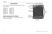
Depth Temperature Speed Suspended targets Transducer frequency or beam width Full Screen Range 50 GPSMAP 400/500 Series Owner's Manual From the Home screen, select Sonar > Full Screen. Using Sonar Using Sonar When connected to a transducer, the following chartplotters can be used as fishfinders: GPSMAP 430s GPSMAP 431s GPSMAP 530s GPSMAP 531s GPSMAP 540s GPSMAP 541s GPSMAP 440s GPSMAP 441s GPSMAP 535s GPSMAP 536s GPSMAP 545s GPSMAP 546s Understanding the Full Screen Select the Full Screen option to view a full-screen graph of the transducer's sonar readings.
Depth Temperature Speed Suspended targets Transducer frequency or beam width Full Screen Range 50 GPSMAP 400/500 Series Owner's Manual From the Home screen, select Sonar > Full Screen. Using Sonar Using Sonar When connected to a transducer, the following chartplotters can be used as fishfinders: GPSMAP 430s GPSMAP 431s GPSMAP 530s GPSMAP 531s GPSMAP 540s GPSMAP 541s GPSMAP 440s GPSMAP 441s GPSMAP 535s GPSMAP 536s GPSMAP 545s GPSMAP 546s Understanding the Full Screen Select the Full Screen option to view a full-screen graph of the transducer's sonar readings.


