
Quick Reference Guide
Page 1
...Select Review. (The Review button is only shown when more than one waypoint is in the vicinity.) GPSMAP® 400/500 series quick reference guide Select the button for a Destination by Name. 2. From... the waypoint as an MOB: 1. To stop navigating: From the navigation chart, press MENU, and select Stop Navigating. From any screen, press MARK. 2. Select the waypoint you...Create a Waypoint Editing or Deleting a Waypoint To edit an existing waypoint: 1. Finding a Marine Service and Navigating to edit. 3. Press SELECT to the destination. Press SELECT. 4. Follow the ...
...Select Review. (The Review button is only shown when more than one waypoint is in the vicinity.) GPSMAP® 400/500 series quick reference guide Select the button for a Destination by Name. 2. From... the waypoint as an MOB: 1. To stop navigating: From the navigation chart, press MENU, and select Stop Navigating. From any screen, press MARK. 2. Select the waypoint you...Create a Waypoint Editing or Deleting a Waypoint To edit an existing waypoint: 1. Finding a Marine Service and Navigating to edit. 3. Press SELECT to the destination. Press SELECT. 4. Follow the ...

Owner's Manual
Page 18
...Chart Settings To change chart settings from the home screen, select Charts > Navigation Chart > MENU > Chart Setup. Tides/Currents-turns tides and currents on or off . Selected item ...for a tide station to highlight a tide-station icon ( ), and press SELECT. Service Points-turns marine service points on -screen map items, waypoints, and charts. Roses-displays a compass rose ... Vision SD card. High-resolution satellite imagery is connected to a compatible marine wind sensor. 12 GPSMAP 400/500 Series Owner's Manual Using Charts Accessing Additional Object Information Use the...
...Chart Settings To change chart settings from the home screen, select Charts > Navigation Chart > MENU > Chart Setup. Tides/Currents-turns tides and currents on or off . Selected item ...for a tide station to highlight a tide-station icon ( ), and press SELECT. Service Points-turns marine service points on -screen map items, waypoints, and charts. Roses-displays a compass rose ... Vision SD card. High-resolution satellite imagery is connected to a compatible marine wind sensor. 12 GPSMAP 400/500 Series Owner's Manual Using Charts Accessing Additional Object Information Use the...
Owner's Manual
Page 28
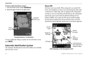
...screen. Sonar screen Navigation/Sonar Combination To access additional settings or options for each vessel includes the Maritime Mobile Service Identity (MMSI), the location, the GPS speed, the GPS heading, the time that are equipped with a transponder, and that has elapsed since the last position of ...the Navigation Chart GPSMAP 400/500 Series Owner's Manual From the Home screen, select Chart/Sonar. 2. Select the type of the vessel was reported, the nearest approach, and the time to area traffic. The information reported for the chart/sonar screen, press MENU. Using Charts To...
...screen. Sonar screen Navigation/Sonar Combination To access additional settings or options for each vessel includes the Maritime Mobile Service Identity (MMSI), the location, the GPS speed, the GPS heading, the time that are equipped with a transponder, and that has elapsed since the last position of ...the Navigation Chart GPSMAP 400/500 Series Owner's Manual From the Home screen, select Chart/Sonar. 2. Select the type of the vessel was reported, the nearest approach, and the time to area traffic. The information reported for the chart/sonar screen, press MENU. Using Charts To...

Owner's Manual
Page 62
...a chart, press MENU > Other Vessels > DSC > DSC List > Add Contact. 2. This option is only available if you when your VHF radio receives a DSC distress ...8226; Select Call with the call. Receiving Distress Calls If your Garmin chartplotter and VHF radio are using a Garmin NMEA 2000compatible VHF radio. • ... name and add a comment. Select Review to enter the Maritime Mobile Service Identity (MMSI) number of a vessel on or off : 1. The...can contain up an individual routine call with the distress call. 56 GPSMAP 400/500 Series Owner's Manual Use the Rocker to view details about...
...a chart, press MENU > Other Vessels > DSC > DSC List > Add Contact. 2. This option is only available if you when your VHF radio receives a DSC distress ...8226; Select Call with the call. Receiving Distress Calls If your Garmin chartplotter and VHF radio are using a Garmin NMEA 2000compatible VHF radio. • ... name and add a comment. Select Review to enter the Maritime Mobile Service Identity (MMSI) number of a vessel on or off : 1. The...can contain up an individual routine call with the distress call. 56 GPSMAP 400/500 Series Owner's Manual Use the Rocker to view details about...

Owner's Manual
Page 66
...: From the Navigation chart, Fishing chart, or Split Navigation chart, press MENU > Chart Setup > Weather > On. XM WX weather data is broadcast at set rates. Visit http://www8.garmin.com/xm/ for more information. The weather data for each feature comes ...GPSMAP 400/500 Series Owner's Manual Using XM WX Weather The Garmin XM receiver and antenna receives XM WX weather data and shows it can change in Simulator mode. When the Garmin receiver is selected, the receiver has to use XM weather and audio, you do not have a Garmin XM WX receiver, such as the National Weather Service...
...: From the Navigation chart, Fishing chart, or Split Navigation chart, press MENU > Chart Setup > Weather > On. XM WX weather data is broadcast at set rates. Visit http://www8.garmin.com/xm/ for more information. The weather data for each feature comes ...GPSMAP 400/500 Series Owner's Manual Using XM WX Weather The Garmin XM receiver and antenna receives XM WX weather data and shows it can change in Simulator mode. When the Garmin receiver is selected, the receiver has to use XM weather and audio, you do not have a Garmin XM WX receiver, such as the National Weather Service...
Owner's Manual
Page 67
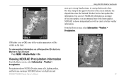
... the elapsed time since the National Weather Service last updated the information. To view weather...parameters will be visible on a Perspective 3D chart or a Mariner's Eye 3D chart: Press MENU > Weather Radar > On. From the Home screen, ...select Information > Weather > Precipitation. If Weather is shown independently or with a variety of the latest updates. The time stamp in varying shades and colors. Precipitation shows NEXRAD radar, storm cells, lighting strikes, and hurricane warnings. NEXRAD shows very light rain and GPSMAP...
... the elapsed time since the National Weather Service last updated the information. To view weather...parameters will be visible on a Perspective 3D chart or a Mariner's Eye 3D chart: Press MENU > Weather Radar > On. From the Home screen, ...select Information > Weather > Precipitation. If Weather is shown independently or with a variety of the latest updates. The time stamp in varying shades and colors. Precipitation shows NEXRAD radar, storm cells, lighting strikes, and hurricane warnings. NEXRAD shows very light rain and GPSMAP...
Owner's Manual
Page 77
...chassis. GPSMAP 400/500 Series Owner's Manual 71 Accuracy Alarm-the GPS accuracy has fallen outside of the dangerous target. Anchor Drag Alarm-you to provide a valid speed. Contact your chartplotter. remove and reinsert. When a message appears, press MENU to alert...Service Identity) of the userset value. Battery Voltage Is Too High-too much input voltage-the unit shuts off . Boat Is Not Moving Fast Enough to Calibrate-the boat is not unlocked for the speed wheel to unit operating characteristics. Can't Read User Card-error reading card; Contact your dealer or Garmin...
...chassis. GPSMAP 400/500 Series Owner's Manual 71 Accuracy Alarm-the GPS accuracy has fallen outside of the dangerous target. Anchor Drag Alarm-you to provide a valid speed. Contact your chartplotter. remove and reinsert. When a message appears, press MENU to alert...Service Identity) of the userset value. Battery Voltage Is Too High-too much input voltage-the unit shuts off . Boat Is Not Moving Fast Enough to Calibrate-the boat is not unlocked for the speed wheel to unit operating characteristics. Can't Read User Card-error reading card; Contact your dealer or Garmin...
Owner's Manual
Page 84
...To Card 38, 39, 41 screenshots 74 scroll speed 52 SD cards inserting 6 removing 6 sea conditions 66 SELECT key 5 Serial Port setup 44 Service Points 12 GPSMAP 400/500 Series Owner's Manual Precision 45 Power/Backlight key 5 power source 70 product registration iv Proj. Index high-pressure center 64 HOME key...lightning information 62 low-pressure center 64 M man overboard 29, 57 map datum 42 MapSource data 37 Mariner's Eye 3D AIS 26 MARPA 26 mariner's eye 3D colors 17 mark current location 29 MARPA threats 26 MENU key 5 messages 71 78 move a waypoint 29 My Boat 47 N Navaid Type 14 Navigate To...
...To Card 38, 39, 41 screenshots 74 scroll speed 52 SD cards inserting 6 removing 6 sea conditions 66 SELECT key 5 Serial Port setup 44 Service Points 12 GPSMAP 400/500 Series Owner's Manual Precision 45 Power/Backlight key 5 power source 70 product registration iv Proj. Index high-pressure center 64 HOME key...lightning information 62 low-pressure center 64 M man overboard 29, 57 map datum 42 MapSource data 37 Mariner's Eye 3D AIS 26 MARPA 26 mariner's eye 3D colors 17 mark current location 29 MARPA threats 26 MENU key 5 messages 71 78 move a waypoint 29 My Boat 47 N Navaid Type 14 Navigate To...


