
Quick Reference Guide
Page 2
...map pointer ( ) to other important information. Press SELECT. From the Home screen, select Information > User Data > Routes > New Route. 2. Select the route to be recorded. © 2009 Garmin Ltd. the current track continues to edit. 3. Acquiring GPS Satellite Signals When you turn on the Rocker...Use Waypoint List, select the first waypoint on the chart indicates your destination. 4. Select Navigate To > Route To. 3. Select MENU to manually adjust the backlight. To turn and press SELECT. To clear the active track: From any chart except the Fish Eye 3D, select MENU...
...map pointer ( ) to other important information. Press SELECT. From the Home screen, select Information > User Data > Routes > New Route. 2. Select the route to be recorded. © 2009 Garmin Ltd. the current track continues to edit. 3. Acquiring GPS Satellite Signals When you turn on the Rocker...Use Waypoint List, select the first waypoint on the chart indicates your destination. 4. Select Navigate To > Route To. 3. Select MENU to manually adjust the backlight. To turn and press SELECT. To clear the active track: From any chart except the Fish Eye 3D, select MENU...
Owner's Manual
Page 5
Viewing Celestial Information 43 Viewing User Data 44 Viewing Other Vessels 47 Configuring the Chartplotter 48 Configuring System Settings 48 Configuring Units of Measure 48 Changing the System Language 49 Configuring ... 61 Using Digital Selective Calling (DSC 63 Using the Chartplotter with a VHF Radio 63 Adding a DSC Contact 64 Viewing the DSC List 64 GPSMAP 400/500 Series Owner's Manual Introduction Receiving Distress Calls 64 Man-Overboard Distress Calls Initiated from a VHF Radio........ 65 Man-Overboard Distress Calls Initiated from the Chartplotter.... 65...
Viewing Celestial Information 43 Viewing User Data 44 Viewing Other Vessels 47 Configuring the Chartplotter 48 Configuring System Settings 48 Configuring Units of Measure 48 Changing the System Language 49 Configuring ... 61 Using Digital Selective Calling (DSC 63 Using the Chartplotter with a VHF Radio 63 Adding a DSC Contact 64 Viewing the DSC List 64 GPSMAP 400/500 Series Owner's Manual Introduction Receiving Distress Calls 64 Man-Overboard Distress Calls Initiated from a VHF Radio........ 65 Man-Overboard Distress Calls Initiated from the Chartplotter.... 65...
Owner's Manual
Page 13
Note: You must have an "s" series unit (such as a GPSMAP 441s) with a connected transducer to use sonar features. • ... To?-access navigation features (page 28). • Information-view information including dashboard options, tides, currents, celestial data, user data, and information about other screens. Press HOME from MapSource® or HomePort™, update to access all other ...version MapSource or HomePort by clicking Help > Check for Software Updates, or check the Garmin Web site at www.garmin.com. Note: If you use a BlueChart g2 Vision SD card. • Sonar-set ...
Note: You must have an "s" series unit (such as a GPSMAP 441s) with a connected transducer to use sonar features. • ... To?-access navigation features (page 28). • Information-view information including dashboard options, tides, currents, celestial data, user data, and information about other screens. Press HOME from MapSource® or HomePort™, update to access all other ...version MapSource or HomePort by clicking Help > Check for Software Updates, or check the Garmin Web site at www.garmin.com. Note: If you use a BlueChart g2 Vision SD card. • Sonar-set ...

Owner's Manual
Page 36
... at your present location. To mark your current location. Select the waypoint on the Navigation chart: 1. OR From the Home screen, select Information > User Data > Waypoints > Options > New Waypoint. 2. Note: Selecting MARK creates a waypoint only at your current location as a waypoint: From any screen..., Water Temp, Comment, or Position). Select Review. (The Review button is in the vicinity.) 3. Select Move. 30 GPSMAP 400/500 Series Owner's Manual Creating and Using Waypoints You can store up to highlight the waypoint on the Navigation chart. From the Navigation chart, use ...
... at your present location. To mark your current location. Select the waypoint on the Navigation chart: 1. OR From the Home screen, select Information > User Data > Waypoints > Options > New Waypoint. 2. Note: Selecting MARK creates a waypoint only at your current location as a waypoint: From any screen..., Water Temp, Comment, or Position). Select Review. (The Review button is in the vicinity.) 3. Select Move. 30 GPSMAP 400/500 Series Owner's Manual Creating and Using Waypoints You can store up to highlight the waypoint on the Navigation chart. From the Navigation chart, use ...

Owner's Manual
Page 37
...pointer ( ) to highlight the waypoint or the MOB on the Navigation chart and press SELECT. 2. OR From the Home screen, select Information > User Data > Waypoints. 2. To create a route from your destination. 2. Press SELECT to save the new location, or press MENU to cancel the move... of objects in the vicinity of all waypoints: From the Home screen, select Information > User Data > Waypoints > Options. Select MENU > Stop Measuring to select GPSMAP 400/500 Series Owner's Manual 31 The measurement information appears in the vicinity.) Creating and Using Routes You can then sort...
...pointer ( ) to highlight the waypoint or the MOB on the Navigation chart and press SELECT. 2. OR From the Home screen, select Information > User Data > Waypoints. 2. To create a route from your destination. 2. Press SELECT to save the new location, or press MENU to cancel the move... of objects in the vicinity of all waypoints: From the Home screen, select Information > User Data > Waypoints > Options. Select MENU > Stop Measuring to select GPSMAP 400/500 Series Owner's Manual 31 The measurement information appears in the vicinity.) Creating and Using Routes You can then sort...
Owner's Manual
Page 38
...a route by selecting the end of the first turn and press SELECT. To save the route. 6. From the Home screen, select Information > User Data > Routes. 2. Select MENU to add additional turns. 5. Select the route to begin navigating the route. Press MENU to cancel, to ... name. 32 To create a route in another location: 1. From the Home screen, select Information > User Data > Routes > New Route. 2. Repeat until the route is calculated. GPSMAP 400/500 Series Owner's Manual Choose the location of the path and selecting Navigate To > Route To. Your route is complete. 5....
...a route by selecting the end of the first turn and press SELECT. To save the route. 6. From the Home screen, select Information > User Data > Routes. 2. Select MENU to add additional turns. 5. Select the route to begin navigating the route. Press MENU to cancel, to ... name. 32 To create a route in another location: 1. From the Home screen, select Information > User Data > Routes > New Route. 2. Repeat until the route is calculated. GPSMAP 400/500 Series Owner's Manual Choose the location of the path and selecting Navigate To > Route To. Your route is complete. 5....
Owner's Manual
Page 39
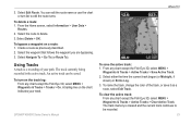
From the Home screen, select Information > User Data > Routes. 2. To bypass a waypoint on the track log: From any chart except the Fish Eye 3D, select MENU > Waypoints & Tracks > Tracks > On. To clear ... name or use the chart or turn on a route: 1. To name the track, change the color of your track. You can be recorded. GPSMAP 400/500 Series Owner's Manual 33 Select either the time the current track began (or Midnight, if shown) or Entire Log. 3. Where To? To turn list to delete...
From the Home screen, select Information > User Data > Routes. 2. To bypass a waypoint on the track log: From any chart except the Fish Eye 3D, select MENU > Waypoints & Tracks > Tracks > On. To clear ... name or use the chart or turn on a route: 1. To name the track, change the color of your track. You can be recorded. GPSMAP 400/500 Series Owner's Manual 33 Select either the time the current track began (or Midnight, if shown) or Entire Log. 3. Where To? To turn list to delete...
Owner's Manual
Page 42
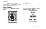
... of fields shown and the type of numerical information. To view the Numbers screen from the Home screen, select Information > Dashboard > Numbers. 36 GPSMAP 400/500 Series Owner's Manual Viewing Information Viewing Information Use the Information screen to six fields of information shown in each field. Viewing a Compass From the Home screen... and customize numerical data including depth, GPS information, and navigation information. Viewing Numbers You can view up to access information about dashboard gauges, tides, currents, user data, and other vessels.
... of fields shown and the type of numerical information. To view the Numbers screen from the Home screen, select Information > Dashboard > Numbers. 36 GPSMAP 400/500 Series Owner's Manual Viewing Information Viewing Information Use the Information screen to six fields of information shown in each field. Viewing a Compass From the Home screen... and customize numerical data including depth, GPS information, and navigation information. Viewing Numbers You can view up to access information about dashboard gauges, tides, currents, user data, and other vessels.
Owner's Manual
Page 50
... copy or merge MapSource data to your chartplotter, select Information > User Data > Data Transfer. 9. Check your chartplotter: 1. From within MapSource, click Transfer > Send to format the data. GPSMAP 400/500 Series Owner's Manual To copy or merge MapSource data to your MapSource version on your... chartplotter from the list. This file provides information to MapSource to Device. 5. From the Send to Device window, select the drive for Software Updates, or check the Garmin Web site at www.garmin....
... copy or merge MapSource data to your chartplotter, select Information > User Data > Data Transfer. 9. Check your chartplotter: 1. From within MapSource, click Transfer > Send to format the data. GPSMAP 400/500 Series Owner's Manual To copy or merge MapSource data to your MapSource version on your... chartplotter from the list. This file provides information to MapSource to Device. 5. From the Send to Device window, select the drive for Software Updates, or check the Garmin Web site at www.garmin....

Owner's Manual
Page 51
... MapSource, name the file . From within HomePort, click the folders or items you want to transfer. 3. Browse to the location on your chartplotter, select Information > User Data > Data Transfer. 7. Select the file name from the SD card to the chartplotter and combine it with an .ADM extension. Insert an SD card... is attached to an SD card: 1. Complete one of the following : • Select the file name from the SD card to the chartplotter. GPSMAP 400/500 Series Owner's Manual 45 Insert an SD card into the SD card slot on the front of the unit. 2. From the Home screen on the front...
... MapSource, name the file . From within HomePort, click the folders or items you want to transfer. 3. Browse to the location on your chartplotter, select Information > User Data > Data Transfer. 7. Select the file name from the SD card to the chartplotter and combine it with an .ADM extension. Insert an SD card... is attached to an SD card: 1. Complete one of the following : • Select the file name from the SD card to the chartplotter. GPSMAP 400/500 Series Owner's Manual 45 Insert an SD card into the SD card slot on the front of the unit. 2. From the Home screen on the front...
Owner's Manual
Page 52
...New File to the network. Complete one of the unit. 2. The data is overwritten on the computer. 46 GPSMAP 400/500 Series Owner's Manual From the Home screen, select Information > User Data > Data Transfer > Copy Built-In Map to copy the maps loaded onto your unit is combined with... existing user data. • Select Replace From Card to or from a NMEA 2000 network: 1. From Windows® Explorer, open the Garmin\UserData...
...New File to the network. Complete one of the unit. 2. The data is overwritten on the computer. 46 GPSMAP 400/500 Series Owner's Manual From the Home screen, select Information > User Data > Data Transfer > Copy Built-In Map to copy the maps loaded onto your unit is combined with... existing user data. • Select Replace From Card to or from a NMEA 2000 network: 1. From Windows® Explorer, open the Garmin\UserData...
Owner's Manual
Page 53
... about other boats, your boat, or the time the call is monitoring. GPSMAP 400/500 Series Owner's Manual 47 To delete all of the boats your chartplotter, select Information > User Data > Clear User Data. 2. See page 23. See page 63 for more information. Viewing Information... DSC List-view the 100 most recent call in the Garmin\UserData folder. 2. Copy ...
... about other boats, your boat, or the time the call is monitoring. GPSMAP 400/500 Series Owner's Manual 47 To delete all of the boats your chartplotter, select Information > User Data > Clear User Data. 2. See page 23. See page 63 for more information. Viewing Information... DSC List-view the 100 most recent call in the Garmin\UserData folder. 2. Copy ...

Owner's Manual
Page 55
... declination for your location. • True-sets true north as the heading reference. • Grid-sets grid north as the heading reference (000º). • User Magnetic-allows you to set how much time or how far before a turn in a route that you transition to the next leg. The auto setting... Labels-for saved routes, this determines whether route turns are using . Turn Transition-set the magnetic variation value. Auto Guidance-set the Auto Guidance parameters: GPSMAP 400/500 Series Owner's Manual 49
... declination for your location. • True-sets true north as the heading reference. • Grid-sets grid north as the heading reference (000º). • User Magnetic-allows you to set how much time or how far before a turn in a route that you transition to the next leg. The auto setting... Labels-for saved routes, this determines whether route turns are using . Turn Transition-set the magnetic variation value. Auto Guidance-set the Auto Guidance parameters: GPSMAP 400/500 Series Owner's Manual 49
Owner's Manual
Page 85
... the SD card slot in order to the maximum voltage allowed (or less) for the unit. Can't Write User Card, Card May Be Full-error reading card; GPSMAP 400/500 Series Owner's Manual 79 When a message appears, press MENU to unit operating characteristics. Battery Alarm-battery voltage has fallen below the...an on the data card is not moving fast enough for the speed wheel to Calibrate-the boat is not unlocked for your dealer or Garmin Product Support. Antenna Input is Shorted-a part of the specified distance range. Decrease the input voltage to perform the function you arrived at...
... the SD card slot in order to the maximum voltage allowed (or less) for the unit. Can't Write User Card, Card May Be Full-error reading card; GPSMAP 400/500 Series Owner's Manual 79 When a message appears, press MENU to unit operating characteristics. Battery Alarm-battery voltage has fallen below the...an on the data card is not moving fast enough for the speed wheel to Calibrate-the boat is not unlocked for your dealer or Garmin Product Support. Antenna Input is Shorted-a part of the specified distance range. Decrease the input voltage to perform the function you arrived at...
Owner's Manual
Page 86
... the sky. Invalid MMSI-enter a valid MMSI. No Waypoints/Routes/Tracks/User Waypoints Found-attempted to transfer user data from another device has more than 250 waypoints and was truncated to...points to transfer on the SD card. Route is data to a route. GPSMAP 400/500 Series Owner's Manual Delete unneeded contacts to fit. Route Truncated-an uploaded route from an SD card... when a fish is 2°F (1.1°C) above or below the temperature specified by your dealer or Garmin Product Support to a location with a clear view of data. Lost Satellite Reception-the unit has lost...
... the sky. Invalid MMSI-enter a valid MMSI. No Waypoints/Routes/Tracks/User Waypoints Found-attempted to transfer user data from another device has more than 250 waypoints and was truncated to...points to transfer on the SD card. Route is data to a route. GPSMAP 400/500 Series Owner's Manual Delete unneeded contacts to fit. Route Truncated-an uploaded route from an SD card... when a fish is 2°F (1.1°C) above or below the temperature specified by your dealer or Garmin Product Support to a location with a clear view of data. Lost Satellite Reception-the unit has lost...
Owner's Manual
Page 87
...either been disconnected or the unit has lost communication with the unit. No additional track log data can be stored without an SD card containing user data being present in memory. If the transducer cable is removed while the unit is set to clear the track log and turn track ...-the speed sensor is an internal problem with the sonar device for the most recent data. Contact your dealer or Garmin Product Support to the connected device. GPSMAP 400/500 Series Owner's Manual 81 Sonar Timeout-there is not detected. Track Log Full-the track log is full. Track Memory is Full, ...
...either been disconnected or the unit has lost communication with the unit. No additional track log data can be stored without an SD card containing user data being present in memory. If the transducer cable is removed while the unit is set to clear the track log and turn track ...-the speed sensor is an internal problem with the sonar device for the most recent data. Contact your dealer or Garmin Product Support to the connected device. GPSMAP 400/500 Series Owner's Manual 81 Sonar Timeout-there is not detected. Track Log Full-the track log is full. Track Memory is Full, ...
Owner's Manual
Page 88
...Copy the appropriate .bmp file on the front of high-quality materials and does not require user maintenance, except cleaning. It is important to any screen displayed on the computer. 82 Caring.... 5. Capturing Screenshots You can capture a screenshot of waypoints. From Windows Explorer, open the Garmin\scrn folder on a screen you want to determine if the engine is NMEA 2000 compatible. ... damage plastic components. Modify the waypoint name or delete the existing waypoint. GPSMAP 400/500 Series Owner's Manual Insert an SD card into an SD card reader that is sensitive to your...
...Copy the appropriate .bmp file on the front of high-quality materials and does not require user maintenance, except cleaning. It is important to any screen displayed on the computer. 82 Caring.... 5. Capturing Screenshots You can capture a screenshot of waypoints. From Windows Explorer, open the Garmin\scrn folder on a screen you want to determine if the engine is NMEA 2000 compatible. ... damage plastic components. Modify the waypoint name or delete the existing waypoint. GPSMAP 400/500 Series Owner's Manual Insert an SD card into an SD card reader that is sensitive to your...
Owner's Manual
Page 89
... no responsibility for life", but is " and XM and Garmin disclaim any direct, indirect, incidental, consequential, special, exemplary or punitive damages or lost profits resulting from use of the Services. USER SAFETY If you use of the Services. THE CONTENT AND ...Manual 83 GPSMAP 441/441s GPSMAP 541/541s GPSMAP 536/536s GPSMAP 546/546s provided "as is merely supplemental and advisory in nature, and therefore cannot be liable to exercise prudent discretion and observe all warranties, express and implied, with respect thereto or the transmission or reception thereof. XM and Garmin...
... no responsibility for life", but is " and XM and Garmin disclaim any direct, indirect, incidental, consequential, special, exemplary or punitive damages or lost profits resulting from use of the Services. USER SAFETY If you use of the Services. THE CONTENT AND ...Manual 83 GPSMAP 441/441s GPSMAP 541/541s GPSMAP 536/536s GPSMAP 546/546s provided "as is merely supplemental and advisory in nature, and therefore cannot be liable to exercise prudent discretion and observe all warranties, express and implied, with respect thereto or the transmission or reception thereof. XM and Garmin...
Owner's Manual
Page 90
...Satellite Services available only to hold harmless the United States National Geospatial-Intelligence Agency. c. PLEASE READ THIS AGREEMENT CAREFULLY. 84 Garmin Ltd. The user agrees to those at xmradio.com. All programming fees and weather data subject to the Software remain in the 48 contiguous... YOUR STATE'S LAWS. This product has not been endorsed or otherwise approved by hardware equipment. GPSMAP 400/500 Series Owner's Manual a. XM Satellite Radio Service Agreement XM Satellite Radio Inc. Hardware and required monthly subscription sold separately.
...Satellite Services available only to hold harmless the United States National Geospatial-Intelligence Agency. c. PLEASE READ THIS AGREEMENT CAREFULLY. 84 Garmin Ltd. The user agrees to those at xmradio.com. All programming fees and weather data subject to the Software remain in the 48 contiguous... YOUR STATE'S LAWS. This product has not been endorsed or otherwise approved by hardware equipment. GPSMAP 400/500 Series Owner's Manual a. XM Satellite Radio Service Agreement XM Satellite Radio Inc. Hardware and required monthly subscription sold separately.

Owner's Manual
Page 91
... Enter Coordinates 30 F factory settings, restoring 6 fish eye 3D 18 settings 18 fishing chart 19 AIS 27 MARPA 27 fishing information 73 GPSMAP 400/500 Series Owner's Manual 85 Time 49 barometric pressure trend 49 Beeper/Display 48 BlueChart g2 Vision using 34-38 bottom lock 61 buttons 5 C Calibrate Water Speed...chart data 10 charts detail 13 fish eye 3D 18 fishing 19 mariner's eye 3D 16 navigation 8 settings 12 cleaning the unit 82 Clear User Data 44 close hauled wind gauge 42 collision alarm 26 colors, hazard 17 Color Scheme 61 Communications 51 Compass 36 compass rose 12 contact information...
... Enter Coordinates 30 F factory settings, restoring 6 fish eye 3D 18 settings 18 fishing chart 19 AIS 27 MARPA 27 fishing information 73 GPSMAP 400/500 Series Owner's Manual 85 Time 49 barometric pressure trend 49 Beeper/Display 48 BlueChart g2 Vision using 34-38 bottom lock 61 buttons 5 C Calibrate Water Speed...chart data 10 charts detail 13 fish eye 3D 18 fishing 19 mariner's eye 3D 16 navigation 8 settings 12 cleaning the unit 82 Clear User Data 44 close hauled wind gauge 42 collision alarm 26 colors, hazard 17 Color Scheme 61 Communications 51 Compass 36 compass rose 12 contact information...


