Owner's Manual
Page 19
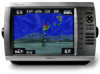
...view from static electricity. The BlueChart g2 Vision Mariner's Eye 3D is on or off. GPSMAP 4000 Series Owner's Manual 15 See page 3 for a three‑dimensional navigation aid. When...that visually represents the sea floor according to the information on BlueChart g2 Vision-compatible Garmin GPS devices. In low humidity environments, you should ground yourself on the Navigation chart... Charts-displays the chart with enhanced bottom contours and without navigational data. This chart works well for offshore deep-sea fishing. • High Resolution Satellite Imagery-provides high ...
...view from static electricity. The BlueChart g2 Vision Mariner's Eye 3D is on or off. GPSMAP 4000 Series Owner's Manual 15 See page 3 for a three‑dimensional navigation aid. When...that visually represents the sea floor according to the information on BlueChart g2 Vision-compatible Garmin GPS devices. In low humidity environments, you should ground yourself on the Navigation chart... Charts-displays the chart with enhanced bottom contours and without navigational data. This chart works well for offshore deep-sea fishing. • High Resolution Satellite Imagery-provides high ...
Owner's Manual
Page 31
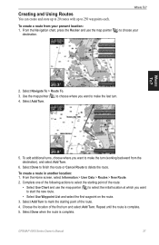
Select Navigate To > Route To. 3. Complete one of the following actions to select the starting point of the first turn (working backward from your destination. Creating and Using Routes You can create and store up to 20 routes with up to delete the route. From the... and use the map pointer ( ) to select the initial location at which you want to make the last turn. 4. Repeat until the route is complete. GPSMAP 4000 Series Owner's Manual 27 Use the map pointer ( ) to choose where you want to choose your present location: 1. To create a route from the ...
Select Navigate To > Route To. 3. Complete one of the following actions to select the starting point of the first turn (working backward from your destination. Creating and Using Routes You can create and store up to 20 routes with up to delete the route. From the... and use the map pointer ( ) to select the initial location at which you want to make the last turn. 4. Repeat until the route is complete. GPSMAP 4000 Series Owner's Manual 27 Use the map pointer ( ) to choose where you want to choose your present location: 1. To create a route from the ...
Owner's Manual
Page 42
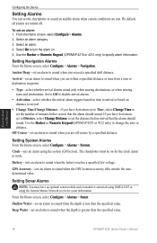
...From the Home screen, select Configure > Alarms > Navigation. Clock-sets an alarm using the Garmin Marine Network to receive sonar information. Deep Water-set an alarm to sound when the depth ... information. From the Home screen, select Configure > Alarms. 2. Use the Rocker or Numeric Keypad (GPSMAP 4210 or 4212 only) to sound when the GPS location accuracy falls outside the userdetermined value. Set to ...arrival alarm triggers based on time to arrival or based on for the clock alarm to work. Configuring the Device Setting Alarms You can set the chartplotter to sound an audible alarm ...
...From the Home screen, select Configure > Alarms > Navigation. Clock-sets an alarm using the Garmin Marine Network to receive sonar information. Deep Water-set an alarm to sound when the depth ... information. From the Home screen, select Configure > Alarms. 2. Use the Rocker or Numeric Keypad (GPSMAP 4210 or 4212 only) to sound when the GPS location accuracy falls outside the userdetermined value. Set to ...arrival alarm triggers based on time to arrival or based on for the clock alarm to work. Configuring the Device Setting Alarms You can set the chartplotter to sound an audible alarm ...
Owner's Manual
Page 62
...and snow up to XM WX Weather, the weather features described in this section work only when the chartplotter is in varying shades and colors. Visit http://www8.garmin.com/xm/ for more information. When the Garmin receiver is turned on the map. NEXRAD is broadcast at set rates. To turn... XM WX Weather and Audio In order to use XM Audio, you must have a Garmin XM audio receiver and an XM Audio subscription. From the Home screen, select Weather > Precipitation. Using XM 58 GPSMAP 4000 Series Owner's Manual The time stamp in appearance or interpretation if the source that ...
...and snow up to XM WX Weather, the weather features described in this section work only when the chartplotter is in varying shades and colors. Visit http://www8.garmin.com/xm/ for more information. When the Garmin receiver is turned on the map. NEXRAD is broadcast at set rates. To turn... XM WX Weather and Audio In order to use XM Audio, you must have a Garmin XM audio receiver and an XM Audio subscription. From the Home screen, select Weather > Precipitation. Using XM 58 GPSMAP 4000 Series Owner's Manual The time stamp in appearance or interpretation if the source that ...
Owner's Manual
Page 76
...update is no longer any space in for assistance updating your network. 72 GPSMAP 4000 Series Owner's Manual Appendix Simulating Operation-the chartplotter is full. Water Speed Sensor is not Working-the water speed sensor is needed. Contact product support for repair. Weather ...weather) the weather service is needed . Check the wheel for assistance updating your network. Software Update Required-a software update is not working properly. Sonar Failed, Unit Needs Repair-there has been a sonar failure and the chartplotter needs to deeper water. Track Log ...
...update is no longer any space in for assistance updating your network. 72 GPSMAP 4000 Series Owner's Manual Appendix Simulating Operation-the chartplotter is full. Water Speed Sensor is not Working-the water speed sensor is needed. Contact product support for repair. Weather ...weather) the weather service is needed . Check the wheel for assistance updating your network. Software Update Required-a software update is not working properly. Sonar Failed, Unit Needs Repair-there has been a sonar failure and the chartplotter needs to deeper water. Track Log ...
Owner's Manual
Page 78
...to stop using DAFIF™, a product of merchantability and fitness for any derivative works based on the Software. Hardware and required monthly subscription sold separately. XM WX ...express or implied, including, but not limited to use of XM Satellite Radio Inc. 74 GPSMAP 4000 Series Owner's Manual The user's sole and exclusive remedy is made by the National ... a valuable trade secret of America copyright laws and international copyright treaties. Available only in Garmin. You agree not to decompile, disassemble, modify, reverse assemble, reverse engineer, or reduce...
...to stop using DAFIF™, a product of merchantability and fitness for any derivative works based on the Software. Hardware and required monthly subscription sold separately. XM WX ...express or implied, including, but not limited to use of XM Satellite Radio Inc. 74 GPSMAP 4000 Series Owner's Manual The user's sole and exclusive remedy is made by the National ... a valuable trade secret of America copyright laws and international copyright treaties. Available only in Garmin. You agree not to decompile, disassemble, modify, reverse assemble, reverse engineer, or reduce...

Technical Reference for Garmin NMEA 2000 Products
Page 9
... T-connector like other voltage source, such as the ground (black) wire. End-powered NMEA 2000 network, correctly designed: + - The Garmin NMEA 2000 power cable connects to the side of under 3.0 Vdc is no more than 3.0 Vdc. The location will depend on the... 10 + 10 + 6) × (4 + 5 + 7) × 0.1 = 2.37 Vdc Cable Distance Network load resistance Technical Reference for the device. • If you will work properly when there is not possible on both sides of the power connection. • If a voltage drop of a T-connector. If you must be visible on...
... T-connector like other voltage source, such as the ground (black) wire. End-powered NMEA 2000 network, correctly designed: + - The Garmin NMEA 2000 power cable connects to the side of under 3.0 Vdc is no more than 3.0 Vdc. The location will depend on the... 10 + 10 + 6) × (4 + 5 + 7) × 0.1 = 2.37 Vdc Cable Distance Network load resistance Technical Reference for the device. • If you will work properly when there is not possible on both sides of the power connection. • If a voltage drop of a T-connector. If you must be visible on...


