Owner's Manual
Page 2
... be used without the express prior written consent of Garmin Ltd. Garmin®, the Gamin logo, GPSMAP®, AutoLocate®, TracBack®, MapSource®, BlueChart®, and g2 Vision® are trademarks of Garmin. or its subsidiaries, registered in the USA and ...Taiwan B Printed in any storage medium, for current updates and supplemental information concerning the use and operation of this document is a registered trademark of Garmin Ltd. Garmin hereby grants permission to change or improve its subsidiaries Garmin International, Inc. 1200 East 151st Street, Olathe, ...
... be used without the express prior written consent of Garmin Ltd. Garmin®, the Gamin logo, GPSMAP®, AutoLocate®, TracBack®, MapSource®, BlueChart®, and g2 Vision® are trademarks of Garmin. or its subsidiaries, registered in the USA and ...Taiwan B Printed in any storage medium, for current updates and supplemental information concerning the use and operation of this document is a registered trademark of Garmin Ltd. Garmin hereby grants permission to change or improve its subsidiaries Garmin International, Inc. 1200 East 151st Street, Olathe, ...
Owner's Manual
Page 8
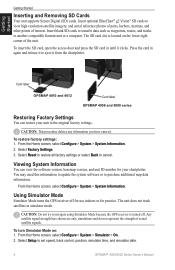
... this information to update the system software or to another compatible Garmin unit or a computer. Viewing System Information You can restore your chartplotter. Insert blank SD cards to transfer data such as waypoints, routes, and tracks to purchase additional map data information. Press the card in simulator mode. Card label GPSMAP 4010 and 4012...
... this information to update the system software or to another compatible Garmin unit or a computer. Viewing System Information You can restore your chartplotter. Insert blank SD cards to transfer data such as waypoints, routes, and tracks to purchase additional map data information. Press the card in simulator mode. Card label GPSMAP 4010 and 4012...
Owner's Manual
Page 32
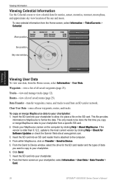
Clear User Data-erase all saved waypoints (page 23). Insert the SD card into an SD card reader that is older than 6.12.2, update to your chartplotter from an SD card or network. Insert the SD card into your chartplotter: 1. To view celestial information from the Home ... moon. From the Send to Device window, select the drive for Software Updates or check the Garmin Web site at www.garmin.com. 3. Insert the SD card into your chartplotter, select Information > User Data > Data Transfer > Card. 28 GPSMAP® 4000/5000 Series Owner's Manual This only needs to be done ...
Clear User Data-erase all saved waypoints (page 23). Insert the SD card into an SD card reader that is older than 6.12.2, update to your chartplotter from an SD card or network. Insert the SD card into your chartplotter: 1. To view celestial information from the Home ... moon. From the Send to Device window, select the drive for Software Updates or check the Garmin Web site at www.garmin.com. 3. Insert the SD card into your chartplotter, select Information > User Data > Data Transfer > Card. 28 GPSMAP® 4000/5000 Series Owner's Manual This only needs to be done ...
Owner's Manual
Page 48
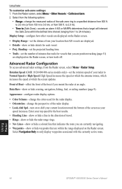
...the following options: • Range-change the perspective of the radar display. • Look-Ahd Spd-turn trails off. Using Radar 44 GPSMAP® 4000/5000 Series Owner's Manual Front of Boat-offset the front of the screen as your radar to shift your current location toward the...24/404/406 series models only)-set the distance from 500 ft. High Speed increases the speed at which the antenna rotates, which the screen updates. Appearance-configure radar display options. • Color Scheme-change the colors used for the radar display. • Orientation-change the measured radius...
...the following options: • Range-change the perspective of the radar display. • Look-Ahd Spd-turn trails off. Using Radar 44 GPSMAP® 4000/5000 Series Owner's Manual Front of Boat-offset the front of the screen as your radar to shift your current location toward the...24/404/406 series models only)-set the distance from 500 ft. High Speed increases the speed at which the antenna rotates, which the screen updates. Appearance-configure radar display options. • Color Scheme-change the colors used for the radar display. • Orientation-change the measured radius...
Owner's Manual
Page 57
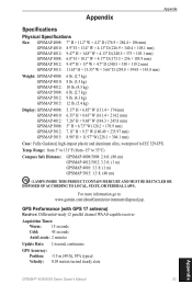
... Cold: 45 seconds AutoLocate: 2 minutes Update Rate: 1/second, continuous GPS Accuracy: Position: Range: from 5° to 131°F (from -15° to : www.garmin.com/aboutGarmin/environment/disposal.jsp. For more information go to 55°C) Compass Safe Distance GPSMAP 4008/5008: 2.6 ft. (80 cm) GPSMAP 4012/5012: 3.3 ft. (1 m) GPSMAP 4010: 3.3 ft. (1 m) GPSMAP 5015: 1.3 ft. (40 cm...
... Cold: 45 seconds AutoLocate: 2 minutes Update Rate: 1/second, continuous GPS Accuracy: Position: Range: from 5° to 131°F (from -15° to : www.garmin.com/aboutGarmin/environment/disposal.jsp. For more information go to 55°C) Compass Safe Distance GPSMAP 4008/5008: 2.6 ft. (80 cm) GPSMAP 4012/5012: 3.3 ft. (1 m) GPSMAP 4010: 3.3 ft. (1 m) GPSMAP 5015: 1.3 ft. (40 cm...
Owner's Manual
Page 59
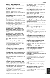
...cannot calculate the route. Check speed wheel for deep water. Contact product support. Database Error-general database error. GPSMAP® 4000/5000 Series Owner's Manual Appendix Deep Water Alarm-(sonar) the boat has entered userdefined value for ...Water Temperature-(temperature sensor/transducer) the water temperature is attached that requires a software update. Contact Garmin Product Support for assistance updating your unit software. Incompatible Device, Software Update Required-an incompatible device is inside the userdefined target temperature zone. Approaching Waypoint -...
...cannot calculate the route. Check speed wheel for deep water. Contact product support. Database Error-general database error. GPSMAP® 4000/5000 Series Owner's Manual Appendix Deep Water Alarm-(sonar) the boat has entered userdefined value for ...Water Temperature-(temperature sensor/transducer) the water temperature is attached that requires a software update. Contact Garmin Product Support for assistance updating your unit software. Incompatible Device, Software Update Required-an incompatible device is inside the userdefined target temperature zone. Approaching Waypoint -...
Owner's Manual
Page 60
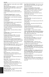
... has been moved to make room. Waypoint Memory is Full, Can't Create Waypoint-the User Waypoint memory is not working properly. GPSMAP® 4000/5000 Series Owner's Manual No Routes Found-no proximity waypoints found while attempting a user data transfer. Proximity Alarm Memory...can be added. Shallow Water Alarm-(sonar) the boat has entered the user-defined shallow-water depth. Software Update Required-a software update is fully inserted. Contact Garmin Product Support for obstructions and check wiring. Sonar Service Lost-(sonar) the unit has lost differential GPS reception (...
... has been moved to make room. Waypoint Memory is Full, Can't Create Waypoint-the User Waypoint memory is not working properly. GPSMAP® 4000/5000 Series Owner's Manual No Routes Found-no proximity waypoints found while attempting a user data transfer. Proximity Alarm Memory...can be added. Shallow Water Alarm-(sonar) the boat has entered the user-defined shallow-water depth. Software Update Required-a software update is fully inserted. Contact Garmin Product Support for obstructions and check wiring. Sonar Service Lost-(sonar) the unit has lost differential GPS reception (...
Owner's Manual
Page 68
or its subsidiaries Garmin International, Inc. 1200 East 151st Street, Olathe, Kansas 66062, USA Garmin (Europe) Ltd. B Printed in Taiwan Liberty House, Hounsdown Business Park, Southampton, Hampshire, SO40 9LR UK Garmin Corporation No. 68, Jangshu 2nd Road, Shijr, Taipei County, Taiwan www.garmin.com April 2009 Part Number 190-01077-00 Rev. For the latest free software updates (excluding map data) throughout the life of your Garmin products, visit the Garmin Web site at www.garmin.com. © 2009 Garmin Ltd.
or its subsidiaries Garmin International, Inc. 1200 East 151st Street, Olathe, Kansas 66062, USA Garmin (Europe) Ltd. B Printed in Taiwan Liberty House, Hounsdown Business Park, Southampton, Hampshire, SO40 9LR UK Garmin Corporation No. 68, Jangshu 2nd Road, Shijr, Taipei County, Taiwan www.garmin.com April 2009 Part Number 190-01077-00 Rev. For the latest free software updates (excluding map data) throughout the life of your Garmin products, visit the Garmin Web site at www.garmin.com. © 2009 Garmin Ltd.
Technical Reference for Garmin NMEA 2000 Products
Page 2
... permission to be reproduced, copied, transmitted, disseminated, downloaded or stored in the USA and other Garmin products. Garmin®, the Garmin logo, and GPSMAP® are registered trademarks of Garmin Ltd. or its subsidiaries, registered in any unauthorized commercial distribution of this manual may not be ... this manual must contain the complete text of this copyright notice and provided further that any storage medium, for current updates and supplemental information concerning the use and operation of this manual onto a hard drive or other electronic storage medium to download...
... permission to be reproduced, copied, transmitted, disseminated, downloaded or stored in the USA and other Garmin products. Garmin®, the Garmin logo, and GPSMAP® are registered trademarks of Garmin Ltd. or its subsidiaries, registered in any unauthorized commercial distribution of this manual may not be ... this manual must contain the complete text of this copyright notice and provided further that any storage medium, for current updates and supplemental information concerning the use and operation of this manual onto a hard drive or other electronic storage medium to download...
Technical Reference for Garmin NMEA 2000 Products
Page 17
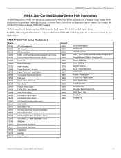
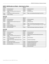
... Information 127250 Vessel Heading 127489 Engine Parameters - Water Referenced 128267 Water Depth 129025 Position - Rapid Update 129026 COG & SOG - Water Referenced Water Depth Position - All Garmin NMEA 2000 devices use the proprietary PGN numbers 126720 and 61184. GPSMAP 6000/7000 Series Chartplotters Receive 059392 ISO Acknowledgment 059904 ISO Request 060928 ISO Address Claim...
... Information 127250 Vessel Heading 127489 Engine Parameters - Water Referenced 128267 Water Depth 129025 Position - Rapid Update 129026 COG & SOG - Water Referenced Water Depth Position - All Garmin NMEA 2000 devices use the proprietary PGN numbers 126720 and 61184. GPSMAP 6000/7000 Series Chartplotters Receive 059392 ISO Acknowledgment 059904 ISO Request 060928 ISO Address Claim...
Technical Reference for Garmin NMEA 2000 Products
Page 22
... GNSS DOPs GNSS Sats in View 059392 059904 060928 126208 ISO Acknowledgment ISO Request ISO Address Claim NMEA - Rapid Update COG & SOG - Dynamic Trip Parameters, Engine Fluid Level (when calibrated using a Garmin chartplotter or marine instrument) ISO Acknowledgement ISO Request ISO Address Claim NMEA-Command/Request/Acknowledge Group Function Engine Parameters - NMEA...
... GNSS DOPs GNSS Sats in View 059392 059904 060928 126208 ISO Acknowledgment ISO Request ISO Address Claim NMEA - Rapid Update COG & SOG - Dynamic Trip Parameters, Engine Fluid Level (when calibrated using a Garmin chartplotter or marine instrument) ISO Acknowledgement ISO Request ISO Address Claim NMEA-Command/Request/Acknowledge Group Function Engine Parameters - NMEA...

Technical Reference for Garmin NMEA 2000 Products
Page 23
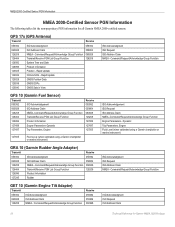
... 126208 NMEA-Command/Request/Acknowledge Group Function 126996 Product Information 128267 Water Depth 130312 Temperature Technical Reference for Garmin NMEA 2000 Products 19 Rapid Update Receive 126208 NMEA - Command/Request/Acknowledge Group Function GST 10 (Garmin Water Speed and Temperature Adapter) Transmit Receive 059392 ISO Acknowledgment 059392 ISO Acknowledgment 060928 ISO Address Claim...
... 126208 NMEA-Command/Request/Acknowledge Group Function 126996 Product Information 128267 Water Depth 130312 Temperature Technical Reference for Garmin NMEA 2000 Products 19 Rapid Update Receive 126208 NMEA - Command/Request/Acknowledge Group Function GST 10 (Garmin Water Speed and Temperature Adapter) Transmit Receive 059392 ISO Acknowledgment 059392 ISO Acknowledgment 060928 ISO Address Claim...
Technical Reference for Garmin NMEA 2000 Products
Page 25
...Satellite System) Position Data VHF 300 Receive 059392 ISO Acknowledgment 059904 ISO Request 060928 ISO Address Claim 126208 NMEA - Rapid Update 129029 GNSS (Global Navigation Satellite System) Position Data 129039 AIS Class B Position Report 129794 AIS Class A Static and ...Position Report AIS SAR Aircraft Position Report Radio Frequency/Mode/Power Radio Frequency/Mode/Power DSC Call Information Technical Reference for Garmin NMEA 2000 Products 21 Command/Request/Acknowledge Group Function VHF 200 Transmit 059392 ISO Acknowledgment 060928 ISO Address Claim 126208 NMEA...
...Satellite System) Position Data VHF 300 Receive 059392 ISO Acknowledgment 059904 ISO Request 060928 ISO Address Claim 126208 NMEA - Rapid Update 129029 GNSS (Global Navigation Satellite System) Position Data 129039 AIS Class B Position Report 129794 AIS Class A Static and ...Position Report AIS SAR Aircraft Position Report Radio Frequency/Mode/Power Radio Frequency/Mode/Power DSC Call Information Technical Reference for Garmin NMEA 2000 Products 21 Command/Request/Acknowledge Group Function VHF 200 Transmit 059392 ISO Acknowledgment 060928 ISO Address Claim 126208 NMEA...

Technical Reference for Garmin NMEA 2000 Products
Page 27
... factory default settings: 1. Refreshing GPS Satellite Acquisition In some situations, if you can force the GPS 17x to provide smoother position data updates. Restoring Factory Default Settings You can help reduce unnecessary drift alarm triggers as well as it is gathered. • Auto-the speed ...The speed filter setting on your NMEA 2000 display device. NMEA 2000-Certified Sensor Configuration Information NMEA 2000-Certified Sensor Configuration Information Garmin NMEA 2000-certified sensors each have moved the boat many miles without using the GPS 17x, for the GPS 17x to ...
... factory default settings: 1. Refreshing GPS Satellite Acquisition In some situations, if you can force the GPS 17x to provide smoother position data updates. Restoring Factory Default Settings You can help reduce unnecessary drift alarm triggers as well as it is gathered. • Auto-the speed ...The speed filter setting on your NMEA 2000 display device. NMEA 2000-Certified Sensor Configuration Information NMEA 2000-Certified Sensor Configuration Information Garmin NMEA 2000-certified sensors each have moved the boat many miles without using the GPS 17x, for the GPS 17x to ...
Technical Reference for Garmin NMEA 2000 Products
Page 41
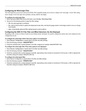
...options to adjust the filter settings. • Off-the wind angle data is not filtered. • On-select a lower number to update the display device less often, and help the gauge needle or wind angle number to move or change in increments of 0.25 second,...the configuration screens. Follow the command with a number between 0 and 254, representing a time constant in increments of software loaded on your Garmin marine instrument, the specific configuration options may stabilize the display. Select Generic Configuration to represent the Automatic setting (for example: ANGLEFILTER=12). To...
...options to adjust the filter settings. • Off-the wind angle data is not filtered. • On-select a lower number to update the display device less often, and help the gauge needle or wind angle number to move or change in increments of 0.25 second,...the configuration screens. Follow the command with a number between 0 and 254, representing a time constant in increments of software loaded on your Garmin marine instrument, the specific configuration options may stabilize the display. Select Generic Configuration to represent the Automatic setting (for example: ANGLEFILTER=12). To...
Technical Reference for Garmin NMEA 2000 Products
Page 42
... than 20 ft. (6 m)? (page 8) For the latest free software updates (excluding map data) throughout the life of your NMEA 2000 installation. Liberty House, Hounsdown Business Park, Southampton, Hampshire, SO40 9LR UK Garmin Corporation No. 68, Jangshu 2nd Road, Sijhih, Taipei County, Taiwan www.garmin.com Part Number 190-00891-00 Rev. Is the...
... than 20 ft. (6 m)? (page 8) For the latest free software updates (excluding map data) throughout the life of your NMEA 2000 installation. Liberty House, Hounsdown Business Park, Southampton, Hampshire, SO40 9LR UK Garmin Corporation No. 68, Jangshu 2nd Road, Sijhih, Taipei County, Taiwan www.garmin.com Part Number 190-00891-00 Rev. Is the...
Installation Instructions
Page 20
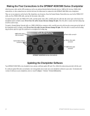
...cable is firmly seated. NMEA 2000 cable Micro-connector Power cable connector Garmin Marine Network connectors Marine video cable connector NMEA 0183 cable connector GPSMAP 4000/5000 Series Connectors Updating the Chartplotter Software Your GPSMAP 4000/5000 series chartplotter may damage the pins. To attach the ...the card. There are wired to the boat, the cables must be connected to the GPSMAP 4000/5000 series chartplotter. If a software update SD card is firmly seated. To attach a Garmin Marine Network cable or a NMEA 2000 Micro-connector cable, carefully press the cable into...
...cable is firmly seated. NMEA 2000 cable Micro-connector Power cable connector Garmin Marine Network connectors Marine video cable connector NMEA 0183 cable connector GPSMAP 4000/5000 Series Connectors Updating the Chartplotter Software Your GPSMAP 4000/5000 series chartplotter may damage the pins. To attach the ...the card. There are wired to the boat, the cables must be connected to the GPSMAP 4000/5000 series chartplotter. If a software update SD card is firmly seated. To attach a Garmin Marine Network cable or a NMEA 2000 Micro-connector cable, carefully press the cable into...
Installation Instructions
Page 21
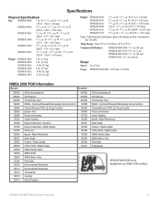
...D (295.8 × 394.9 × 143.8 mm) Weight: GPSMAP 4008: GPSMAP 4010: GPSMAP 4012: GPSMAP 5008: GPSMAP 5012: GPSMAP 5015: 6 lb. (2.7 kg) 8 lb. (3.6 kg) 10 lb. (4.5 kg) 6 lb. (2.7 kg) 10 lb. (4.5 kg) 12 lb. (5.4 kg) Display: GPSMAP 4008: GPSMAP 4010: GPSMAP 4012: GPSMAP 5008: GPSMAP 5012: GPSMAP 5015: 5 /11 64 in . W (161.4 × 214...Depth 129025 Position - Command/Request/Acknowledge Group Function Transmit/Receive PGN List Group Function Product Information Vessel Heading Speed - Rapid Update GNSS Position Data GNSS Sats in . W × 4 /13 64 in . H × 14 /51 64...
...D (295.8 × 394.9 × 143.8 mm) Weight: GPSMAP 4008: GPSMAP 4010: GPSMAP 4012: GPSMAP 5008: GPSMAP 5012: GPSMAP 5015: 6 lb. (2.7 kg) 8 lb. (3.6 kg) 10 lb. (4.5 kg) 6 lb. (2.7 kg) 10 lb. (4.5 kg) 12 lb. (5.4 kg) Display: GPSMAP 4008: GPSMAP 4010: GPSMAP 4012: GPSMAP 5008: GPSMAP 5012: GPSMAP 5015: 5 /11 64 in . W (161.4 × 214...Depth 129025 Position - Command/Request/Acknowledge Group Function Transmit/Receive PGN List Group Function Product Information Vessel Heading Speed - Rapid Update GNSS Position Data GNSS Sats in . W × 4 /13 64 in . H × 14 /51 64...

Installation Instructions
Page 24
G Printed in Taiwan or its subsidiaries Garmin International, Inc. 1200 East 151st Street, Olathe, Kansas 66062, USA Garmin (Europe) Ltd. Liberty House, Hounsdown Business Park, Southampton, Hampshire, SO40 9LR UK Garmin Corporation No. 68, Jangshu 2nd Road, Sijhih, Taipei County, Taiwan www.garmin.com Part Number 190-00779-02 Rev. June 2010 © 2010 Garmin Ltd. For the latest free software updates (excluding map data) throughout the life of your Garmin products, visit the Garmin Web site at www.garmin.com.
G Printed in Taiwan or its subsidiaries Garmin International, Inc. 1200 East 151st Street, Olathe, Kansas 66062, USA Garmin (Europe) Ltd. Liberty House, Hounsdown Business Park, Southampton, Hampshire, SO40 9LR UK Garmin Corporation No. 68, Jangshu 2nd Road, Sijhih, Taipei County, Taiwan www.garmin.com Part Number 190-00779-02 Rev. June 2010 © 2010 Garmin Ltd. For the latest free software updates (excluding map data) throughout the life of your Garmin products, visit the Garmin Web site at www.garmin.com.

